FREE! Click here to Join FunTrivia. Thousands of games, quizzes, and lots more!
Quiz about Exploring South Korea by Map

Exploring South Korea by Map Trivia Quiz


Come see some of the interesting questions that are raised about a country by different kinds of maps.

A photo quiz by looney_tunes. Estimated time: 4 mins.
  1. Home
  2. »
  3. Quizzes
  4. »
  5. Geography Trivia
  6. »
  7. Asia
  8. »
  9. Korea

Author
looney_tunes
Time
4 mins
Type
Photo Quiz
Quiz #
336,349
Updated
Dec 03 21
# Qns
10
Difficulty
Average
Avg Score
8 / 10
Plays
4408
Awards
Top 5% quiz!
Last 3 plays: Guest 14 (8/10), leith90 (10/10), Guest 121 (8/10).
-
Question 1 of 10
1. This is a map, published around 1750, of a city identified as Gyeongdo. What is the contemporary name of this city, which is the largest city in the Republic of Korea? Hint


Question 2 of 10
2. This location map of South Korea shows that it only shares a land border with one other country. What is its only neighbour? Hint


Question 3 of 10
3. This map, dating from the early 18th century, shows the Korean peninsula running vertically on the right side of the map. What is the name of the body of water separating the Korean peninsula from the country, now known as the People's Republic of China, on the left side of the map? Hint


Question 4 of 10
4. South Korea's nearest neighbour without a shared land border is shown in the lower right corner of this map. What archipelagic nation claims sovereignty over Tsushima Island, which lies approximately 50 km (30 mi) off the coast of South Korea?
Hint


Question 5 of 10
5. The red circle on this map indicates what is claimed to be the easternmost point of South Korea, although ownership of the territory is disputed. Which of the following is NOT a name for this island? Hint


Question 6 of 10
6. This map of the maritime border between North and South Korea shows the westernmost point of South Korea, an island numbered '2' on the map. What is its name? Hint


Question 7 of 10
7. This map of South Korea's national parks includes the country's largest island, Jeju, number 20. The island of Jejudo is the location of the highest point in South Korea. What is the name of this dormant volcano? Hint


Question 8 of 10
8. South Korea is known to be very mountainous, as this topographic map shows. What is the name of the mountain range extending along much of its eastern coast? Hint


Question 9 of 10
9. This map of the administrative divisions of South Korea shows Seoul, the country's only Special City, as 1, and Sejong, a Special Self-governing City, as 6. The Special Autonomous Province of Jeju is number 16. The numbers 2 through 7 (excluding 6) and 8 through 15 indicate the location of the other two types of administrative division to be found in South Korea. What are these divisions called? Hint


Question 10 of 10
10. This aerial photo from NASA shows Cheonsuman Bay, in the city of Seosan, on the western coast of Korea. This area is host to an annual festival celebrating which of the following? Hint


(Optional) Create a Free FunTrivia ID to save the points you are about to earn:

arrow Select a User ID:
arrow Choose a Password:
arrow Your Email:


View Image Attributions for This Quiz

Most Recent Scores
Oct 13 2024 : Guest 14: 8/10
Oct 11 2024 : leith90: 10/10
Oct 10 2024 : Guest 121: 8/10
Sep 27 2024 : Guest 75: 5/10

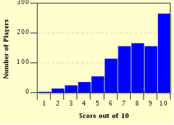
Score Distribution

quiz
Quiz Answer Key and Fun Facts
1. This is a map, published around 1750, of a city identified as Gyeongdo. What is the contemporary name of this city, which is the largest city in the Republic of Korea?

Answer: Seoul

Nearly a quarter of the population of the country of South Korea, formally known as the Republic of Korea, lives in the city of Seoul, which is the nation's capital. The city has had a number of different names since it was founded in 18 BCE, including Wiryeseong, Hanju, Namgyeong, Hanseong, and Hanyang. During the Japanese colonial period, it was referred to as Keijo or Gyeonseong.

The modern name, in use since the 19th century, is possibly derived from a Korean word meaning 'capital city', and possibly from a word meaning 'new walls' - Seoul was a walled fortress city from the early fifteenth century until the 1950s, when the walls were mostly destroyed during the Korean War.
2. This location map of South Korea shows that it only shares a land border with one other country. What is its only neighbour?

Answer: Democratic People's Republic of North Korea

The Republic of South Korea has a land border only with North Korea (which in turn borders both China and Russia). The armistice agreement at the end of the Korean War established the two separate countries, with a demilitarized zone approximately four km wide, running diagonally across the peninsula near the 38th parallel.

At the start of the 21st century, this border was one of the most heavily armed borders in the world.
3. This map, dating from the early 18th century, shows the Korean peninsula running vertically on the right side of the map. What is the name of the body of water separating the Korean peninsula from the country, now known as the People's Republic of China, on the left side of the map?

Answer: Yellow Sea

The Yellow Sea lies to the west of the Korean peninsula, separating it from mainland China. The Sea of Japan is to the east of the Korean peninsula, while the Korea Strait and the East China Sea are on the southern end of the peninsula.
4. South Korea's nearest neighbour without a shared land border is shown in the lower right corner of this map. What archipelagic nation claims sovereignty over Tsushima Island, which lies approximately 50 km (30 mi) off the coast of South Korea?

Answer: Japan

Tsushima Island is about halfway between the Japanese city of Nagasaki and the Korean city of Busan. Artificial canals have divided the island up into two smaller islands, but they are still considered a single entity.

Historically, Japan and Korea have been involved in a great deal of cultural sharing via trade and immigration. However, the Japanese invasions of Korea at the end of the 16th century left a residual strain on the relationship, which was exacerbated by the Japanese occupation of Korea from 1910 through World War II.
5. The red circle on this map indicates what is claimed to be the easternmost point of South Korea, although ownership of the territory is disputed. Which of the following is NOT a name for this island?

Answer: Iwo Jima

The Liancourt Rocks (given their English name from a French whaling ship that was nearly wrecked there in 1849) are the subject of a territorial dispute between South Korea (which calls the islands Dokdo) and Japan (which calls them Takeshima). There are two large islands and between 30 and 40 smaller ones.

Their location in excellent fishing grounds, and the suspected valuable gas deposits nearby, is probably enough explanation for the running territorial dispute. In the early years of the 21st century, they were administered by the Koreans, who built a lighthouse, a helicopter pad, police barracks, and two desalination plants, amongst other capital projects on these barely-inhabited islands.

In 2010 there were two permanent residents (fishers), and a small number of Coast Guard and naval personnel posted there for short periods of time.
6. This map of the maritime border between North and South Korea shows the westernmost point of South Korea, an island numbered '2' on the map. What is its name?

Answer: Baengnyeongdo

The Korean word for island is 'do', and that is the ending used on the names of all of its approximately 3,000 islands. The name Baengnyeongdo means 'white wing island', descriptive of the island's shape, which is said (with quite a bit of imagination) to suggest a flying ibis.

The blue line on the map is the maritime boundary mandated by the United Nations in 1956, while the red one shows the boundary acknowledged by North Korea.

Yeonpyeongdo (shown in the map as #1) and Daecheongdo (shown as #3) are also located right on the boundary between the two countries. All of these islands are the target for people wishing to escape from North Korea by boat, and have also been involved in numerous naval skirmishes over the years.

The three incorrect islands are islands of Japan, not Korea.
7. This map of South Korea's national parks includes the country's largest island, Jeju, number 20. The island of Jejudo is the location of the highest point in South Korea. What is the name of this dormant volcano?

Answer: Hallasan

Hallasan, whose height is 1950 m (6400 ft), is only one of the volcanic features of Jeju. There are nearly 400 satellite volcanoes, and an extensive system of lava tubes, caves formed as magma flowed underground. The Jeju Volcanic Island and Lava Tubes is a World Heritage Site. Jeju is also home to a wide range of plant species (nearly half of all species found in South Korea can be found there), and archaeological evidence in the Pillemot Cave that the island has been occupied since Paleolithic times.
8. South Korea is known to be very mountainous, as this topographic map shows. What is the name of the mountain range extending along much of its eastern coast?

Answer: Taebaek Mountains

Most of South Korea's agriculture occurs in the southeastern region of the Nakdong River basin, and in the western coastal plains; both of these regions appear in green on the topographical map. The Taebaek Mountains run from Hwanngnyong Mountain in North Korea along the eastern edge of the peninsula, terminating near the southern city of Busan. The range is over 500 km (300 miles) in length, and has a number of peaks well over 1,000 m (3,300 ft) in height. On the map, areas of white indicate elevations over 1250 m - as you can see, there are quite a few! The Taebaek Mountains are an important source of iron, coal and limestone (and there you have a steel industry in the making), and the gentler western slopes are an excellent source of timber.

The Atlas mountains are found in northern Africa, the Hindu Kush in Afghanistan and Pakistan, and the Urals in Russia, where they are generally considered to define the boundary between Europe and Asia.
9. This map of the administrative divisions of South Korea shows Seoul, the country's only Special City, as 1, and Sejong, a Special Self-governing City, as 6. The Special Autonomous Province of Jeju is number 16. The numbers 2 through 7 (excluding 6) and 8 through 15 indicate the location of the other two types of administrative division to be found in South Korea. What are these divisions called?

Answer: 2-7 are metropolitan cities, 8-15 are provinces

South Korea has nine provinces (one Autonomous) and seven metropolitan cities (two of which are designated as Special). Each of these administrative regions is further subdivided for the purposes of local government into si (cities), gun (counties), gu (districts), eup (towns), myeon (townships), dong (neighbourhoods) and ri (villages).

The smaller divisions do not have exact equivalents in English, but the terms in brackets give an idea of what kind of entity they roughly refer to.
10. This aerial photo from NASA shows Cheonsuman Bay, in the city of Seosan, on the western coast of Korea. This area is host to an annual festival celebrating which of the following?

Answer: Migratory birds

Cheonsuman Bay is the world's largest sanctuary for migratory birds, and nearly half a million specimens of over 300 different species can be found there year-round. These include the Baikal teal (whose dancing ritual is one of the tour highlights during the festival), Eurasian spoonbill, and of course white storks, as well as some more familiar ducks and gulls.

The Seosan Cheonsuman International Bird-Watcher's Fair, held in late November and early December, features plenty of bird-watching opportunities, as well as temple visits, the chance to engage in sweet-potato digging (why?), classes in traditional ceramics, and lots of food!
Source: Author looney_tunes

This quiz was reviewed by FunTrivia editor Pagiedamon before going online.
Any errors found in FunTrivia content are routinely corrected through our feedback system.
Related Quizzes
This quiz is part of series Written for the Bus Ride:

You think you can write just one, but it turns out that writing quizzes suitable for being visited by the tourists on the Bus Ride is addictive - there's just so much to find out!

  1. Saint Vincent and the Grenadines Average
  2. Barbados, Land of the Flying Fish Average
  3. Calypso Country - Trinidad and Tobago Average
  4. "The Land, the People, the Light" - Saint Lucia Average
  5. A Provincial Tour of Zimbabwe Average
  6. Republic of Benin, Formerly Dahomey Average
  7. The Landlocked Kingdom of Lesotho Average
  8. Honduras: "Free, Sovereign and Independent" Average
  9. Exploring Kosovo Average
  10. Democratic Republic of Sao Tome and Principe Average
  11. "We Stand With God" in Vanuatu Average
  12. They Came to Baghdad Average

11/19/2024, Copyright 2024 FunTrivia, Inc. - Report an Error / Contact Us