FREE! Click here to Join FunTrivia. Thousands of games, quizzes, and lots more!
Quiz about A Handy Guide to Colombia

A Handy Guide to Colombia Trivia Quiz


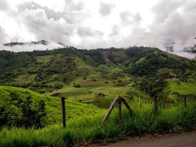
Are you after some basic facts about Colombia? Then this quiz on the South American country might be just the thing you need. Try it and find out...

A photo quiz by Fifiona81. Estimated time: 3 mins.
  1. Home
  2. »
  3. Quizzes
  4. »
  5. Geography Trivia
  6. »
  7. South America
  8. »
  9. Colombia

Author
Fifiona81
Time
3 mins
Type
Photo Quiz
Quiz #
386,971
Updated
Dec 03 21
# Qns
10
Difficulty
Easy
Avg Score
8 / 10
Plays
1825
Awards
Top 5% quiz!
Last 3 plays: Guest 165 (1/10), alythman (9/10), Guest 136 (9/10).
-
Question 1 of 10
1. For most of the period 1717 to 1819, Colombia was part of a wider Spanish colony along with its neighbours Venezuela, Ecuador, and Panama. By what name was this historic territory known? Hint


Question 2 of 10
2. In western Colombia, the Andes mountain range divides into three parallel ranges known by what collective term? Hint


Question 3 of 10
3. Large swathes of south-east Colombia are extremely sparsely populated. Why is this? Hint


Question 4 of 10
4. With which of Colombia's four South American neighbours does it share the shortest land border? Hint


Question 5 of 10
5. Which large bird appears at the top of Colombia's coat of arms with its wings outstretched? Hint


Question 6 of 10
6. The two highest mountains in Colombia are almost identical in height and named after two important figures in the history of Central and South America. One is Pico Cristóbal Colón, what is the other? Hint


Question 7 of 10
7. Which major river forms part of the border between Colombia and Venezuela? Hint


Question 8 of 10
8. The Museo del Oro is a major tourist attraction in Colombia's capital city, Bogotá. To what is it dedicated? Hint


Question 9 of 10
9. The National Archeological Park of Tierradentro is particularly known for its pre-Columbian hypogea. What are these? Hint


Question 10 of 10
10. The northern-most of Colombia's 32 departments is an archipelago lying off the east coast of Central America. What is the name of the largest island in this group? Hint


(Optional) Create a Free FunTrivia ID to save the points you are about to earn:

arrow Select a User ID:
arrow Choose a Password:
arrow Your Email:


View Image Attributions for This Quiz

Most Recent Scores
Oct 25 2024 : Guest 165: 1/10
Oct 24 2024 : alythman: 9/10
Oct 11 2024 : Guest 136: 9/10
Oct 04 2024 : Guest 64: 5/10

Score Distribution

quiz
Quiz Answer Key and Fun Facts
1. For most of the period 1717 to 1819, Colombia was part of a wider Spanish colony along with its neighbours Venezuela, Ecuador, and Panama. By what name was this historic territory known?

Answer: Viceroyalty of New Granada

The area that is now part of the modern-day country of Colombia first came under the control of the Spanish Empire in the early 16th century. The explorer Gonzalo Jiménez de Quesada (who originally came from the Spanish city of Granada, whose most famous landmark, the Alhambra, is shown in the picture clue) named it the "New Kingdom of Granada" in 1536. The area became the Viceroyalty of New Granada in 1717 following a reform in the governance structure of Spain's colonies in South and Central America. In addition to modern day Venezuela, Ecuador and Panama, the Viceroyalty also included portions of what later became Brazil, Trinidad and Tobago, Peru and Guyana.

Colombia gained independence from Spain in 1819 and along with other former members of the Viceroyalty of New Granada became a member of the Republic of Gran Colombia. This alliance failed in 1831, with Colombia becoming the major part of a new Republic of New Granada. It went on to become the United States of Colombia in 1863 and then took its modern title of the Republic of Colombia in 1886.

The incorrect options all include the names of other Spanish port cities and provincial capitals.
2. In western Colombia, the Andes mountain range divides into three parallel ranges known by what collective term?

Answer: Cordilleras

The three ranges in question are (from west to east) known as the Cordillera Occidental, the Cordillera Central and the Cordillera Oriental. They are separated by deep river valleys, with the Cauca River flowing between the Cordillera Occidental and the Cordillera Central and the Magdalena River forming the valley between the Cordillera Central and the Cordillera Oriental. All three ranges have numerous mountains that exceed 4,000 metres (13,000 feet) above sea level; the highest peak in the Cordilleras is the Nevada del Huila in the Central range at 5,365 metres (17,600 feet). The ranges also feature various high plateaus and fertile basins, which explains how the majority of the country's population are able to live on or around these mountains. The country's capital Bogotá is in the Cordillera Oriental, while its second-largest city Medellín is in the Cordillera Central.

Cordillera is a term in physical geography for chains of mountain ranges that often have a complex geological structure. The name comes from a Spanish term originally derived from 'cordilla' (or 'rope' in English - hence the picture clue). Spurs are ridges or subpeaks that jut out from the sides of higher land formations; massifs are large mountains, or groups of mountains that are separated from others by geological faults; and tepuis are table-top mountains - ones with a large, flat top.
3. Large swathes of south-east Colombia are extremely sparsely populated. Why is this?

Answer: They are covered by parts of the Amazon rainforest

About 400,000 square kilometres (35%) of Colombia's land - an area almost as large as the U.S. state of California - is taken up by a chunk of the Amazon rainforest (a view of which is shown in the picture clue). Although this area makes up a sizeable portion of Colombia, it accounts for only around 10% of the rainforest in question, which mostly lies within northern Brazil but also covers parts of Peru and six other South American nations. The rainforest is centred around the basin of the Amazon River and is one of the most biodiverse areas on Earth. However, although the hot, wet jungle of trees and other flora make an ideal habitat for a whole range of creatures, humans don't tend to be so keen on living there. In fact, the most common human activities in the rainforest are the agriculture and logging industries that have had a severe detrimental impact on the area's ecology.

Lake Titicaca is located on the border between Bolivia and Peru; the Atacama Desert can be found in Chile; and south-east Colombia has the hot and wet climate typically associated with rainforest areas.
4. With which of Colombia's four South American neighbours does it share the shortest land border?

Answer: Ecuador

Colombia is bordered by Ecuador and Peru to the south, Brazil and Venezuela to the east, and Venezuela and Panama to the north. It also has a western coastline on the Pacific Ocean and a northern one on the Caribbean Sea. Although its shortest land border is the 225 kilometres that connect it to Panama on the Central American isthmus, its shortest with one of its South American neighbours is the one with Ecuador at 590 kilometres. (Its borders with Peru, Brazil and Venezuela measure 1,496 km, 1,643km and 2,050 km respectively.)

The eastern end of the Colombia-Ecuador border starts at the tripoint between Colombia, Ecuador and Peru and follows the course of the Putumayo River before turning south and joining the course of the San Miguel and Rancheria Rivers into the Andes mountains. The border continues east-north-east across the Andes and then follows the course of the Mataje River to the Pacific Ocean.

Ecuador is Spanish for 'equator' and the equator passes through both Ecuador and Colombia. The picture clue shows one of the many monuments marking the position of the equator around the world.
5. Which large bird appears at the top of Colombia's coat of arms with its wings outstretched?

Answer: Andean condor

As its name might suggest, the Andean condor (pictured) is not endemic to Colombia despite the fact that it sits proudly on top of the coat of arms adopted by the country in 1834. It is Colombia's national bird, but also has the same status in Bolivia, Chile and Ecuador. In heraldic terms, the Andean condor on the country's coat of arms is described as "facing dexter, with wings inverted displayed" - a fancy term for "looking to the right (dexter) with its wings spread out (displayed) and pointing downwards (inverted)".

The Andean condor is a rare bird, but can be found along the whole range of the Andes mountains that stretch down the western coast of South America. Populations in the northern part of the continent, including Colombia, have been under particular threat thanks to widespread loss of their preferred habitat and hunting practices.

The turkey vulture is another member of the Cathartidae family of New World vultures. The kori bustard is native to Africa and is that continent's largest bird that is capable of flight. The wandering albatross is found around Antarctic regions and has the largest wingspan of all living bird species.
6. The two highest mountains in Colombia are almost identical in height and named after two important figures in the history of Central and South America. One is Pico Cristóbal Colón, what is the other?

Answer: Pico Simón Bolívar

Pico Cristóbal Colón and Pico Simón Bolívar are located close together in the Sierra Nevada de Santa Maria mountain range and are just 42 kilometres (26 miles) from Colombia's northern coast on the Caribbean Sea. The mountains both stretch up to an altitude of around 5,700 metres (18,700 feet), making them some of the highest coastal mountains in the world.

Pico Cristóbal Colón is named after Christopher Columbus, from whose surname the name 'Colombia' is derived. Despite this, none of Columbus' four main voyages brought him to the area that became modern-day Colombia, although he did sail along the coast of Panama, which gained its independence from Colombia in 1903. Simón Bolívar was the Venezuelan politician who is generally credited with obtaining independence from Spain for many South American nations, including Colombia.

Juan Ponce de León was a Spanish governor of Puerto Rico and is often credited with discovering Florida; Hernán Cortés conquered much of Mexico for the Spanish by defeating the Aztec Empire; and Francisco Pizarro defeated the Inca Empire, capturing much of modern-day Peru in the process.
7. Which major river forms part of the border between Colombia and Venezuela?

Answer: The Orinoco

The Orinoco River forms part of the 2,000-kilometre (1,250-mile) border between Colombia and Venezuela. The majority of the course of the river lies in Venezuela, as the river flows across that country to its mouth on the Atlantic Ocean. However, eastern Colombia contains around 25% of the Orinoco's drainage basin and a significant number of its tributaries. The section of the river that flows north along the Colombia-Venezuela border is classified as part of the 'Middle Orinoco' and is approximately 270 kilometres (170 miles) in length.

The picture clue shows a map of the border, dating from around 1891.

The Amazon does flow through Colombia into Brazil, but south of its border with Venezuela. The Paraná is the second-longest river in South America flowing south through Brazil, Paraguay and Argentina to its confluence with the Uruguay River, at which point the two rivers become known as the Rio de la Plata.
8. The Museo del Oro is a major tourist attraction in Colombia's capital city, Bogotá. To what is it dedicated?

Answer: Gold

The city of Bogotá is home to dozens of museums and galleries, but the Museo del Oro (in English, Museum of Gold) is one of the most popular. Its collection includes thousands of beautiful gold-alloy artefacts known as 'Tumbaga', which were created by people from the native pre-Columbian civilisations that pre-dated the arrival of European colonists. Cultures whose work is represented in the museum include the Quimbaya, Calima and Muisca civilisations.

Gold was a major factor in the success of the Spanish conquest of Colombia and its neighbouring countries. It helped to finance the Spanish Empire and cemented Spain's position as a global power in the 16th and 17th centuries. Legends related to gold, such as that of the lost city of El Dorado, also helped drive the European desire to explore and exploit the South American continent.

Since it seems unlikely that the Museo del Oro has dedicated any space to the display of chocolate coins wrapped in gold-coloured foil, this quiz has stepped into the breach and put up a picture of them instead...
9. The National Archeological Park of Tierradentro is particularly known for its pre-Columbian hypogea. What are these?

Answer: Underground tombs

The National Archeological Park of Tierradentro is located around 100 kilometres (62 miles) east of the city of Popayán in south-west Colombia. It was registered as a UNESCO World Heritage Site in 1995.

The site's hypogea are underground tombs consisting of a series of rooms around five to eight metres (16-26 feet) below ground level and generally entered via a spiral staircase. Each hypogeum has a main chamber connected to several smaller ones that each held a body. The main chambers are highly decorated with red, black and white designs and would originally have contained an array of grave goods and treasures, but were probably looted of the majority of their contents during the 18th and 19th centuries. The site has been dated to between the 6th and 10th centuries AD and as such is associated with the native people who lived in the pre-Columbian era.

The picture clue is a photo taken in the chamber of one of Tierradentro's hypogea, and in case you were wondering, the scientific name for the peanut is Arachis hypogaea...
10. The northern-most of Colombia's 32 departments is an archipelago lying off the east coast of Central America. What is the name of the largest island in this group?

Answer: San Andrés

The island of San Andrés is the largest of the islands and cays that make up the department of the Archipelago of San Andrés, Providencia and Santa Catalina. The other incorrect option, Gorgona, is an island off the west coast of Colombia in the Pacific Ocean. The archipelago can be split into two main groups: San Andrés and its surrounding islets and reefs to the south, and the smaller islands of Providencia and Santa Catalina to the north. They are approximately 380 kilometres (240 miles) off the east coast of Nicaragua and have been the subject of much dispute between Colombia and Nicaragua over their sovereignty.

San Andrés was first claimed by the Spanish in the early 16th century but has been settled by various European nations over the centuries, including the Dutch and British in addition to the Spanish. It came under Colombian control thanks to the fact that it joined the Viceroyalty of New Granada in 1790. Andrés is a Spanish variant of the English name Andrew, and the islands share a very similar flag to that of the Saltire, or St. Andrew's Cross, the national flag of Scotland that is shown in the picture clue.
Source: Author Fifiona81

This quiz was reviewed by FunTrivia editor agony before going online.
Any errors found in FunTrivia content are routinely corrected through our feedback system.
Related Quizzes
This quiz is part of series A Handy Guide to...:

Are you after some basic facts about countries and places around the world? Then these quizzes might be just the thing you need. Try them and find out...

  1. A Handy Guide to the Caribbean Easier
  2. A Handy Guide to Colombia Easier
  3. A Handy Guide to Ethiopia Average
  4. A Handy Guide to Fiji Average
  5. A Handy Guide to Kazakhstan Average
  6. A Handy Guide to Mauritius Average
  7. A Handy Guide to Papua New Guinea Average
  8. A Handy Guide to Paraguay Average
  9. A Handy Guide to Singapore Average
  10. A Handy Guide to Spain Average
  11. A Handy Guide to Vanuatu Average
  12. A Handy Guide to Venezuela Easier

10/31/2024, Copyright 2024 FunTrivia, Inc. - Report an Error / Contact Us