Quiz Answer Key and Fun Facts
1. First things first: we need to get you to Peru to meet up with the rest of the tour group. If you've gotten this far, you probably know that Peru is in South America - but is it north or south of the equator?
2. We'll begin our tour in the northern part of the country, in the city of Iquitos. With 400,000 people, this is the largest city in the world that cannot be reached by car. Why is it so inaccessible?
3. Now we'll head across country to the south of Peru - be sure to admire the scenery as we pass! We'll cross through Lima, the immense coastal capital, and take a lunch break in the Plaza de Armas near its beautiful colonial churches. Our destination is the Islas Ballestas, home to tens of thousands of birds and a mainstay of the economy. What makes these islands so valuable to the people who live nearby?
4. Let's go inland now to the desert city of Nazca, which was the center of a great and mysterious civilization about 1500 years ago. Artists and mathematicians of that people worked together to produce beautiful, sophisticated lines and drawings in the desert. What is the best way to see these famous Nazca lines?
5. For our next stop, we'll move further inland and up into the mountains on our way to the beautiful city of Arequipa, the second-largest in Peru. This colonial town, nestled dangerously between several active volcanoes, is nicknamed "The White City." Why?
6. We'll break for a few hours to allow you to explore downtown Arequipa; it's a great walking city. Afterwards we'll continue east, to the body of water Peru shares with Bolivia. What is the name of this place, the highest navigable lake in the world?
7. Take your time as we explore this lake on the Peru-Bolivia border; at 3812 meters above sea level, you should be careful not to exert yourself too much (and to apply plenty of sunscreen!) We'll take a boat tour to the "Islas Flotantes," artificial islands constructed by the Uros people when they feared their mainland neighbors were growing too aggressive. From what material do the Uros construct their islands?
8. Did everyone enjoy the cruise? We'll head north now, remaining in the Andes but descending about 400 meters. Our destination is a city that has been called "the archaeological capital of the Americas," thanks to its century as the capital of the vast Inca empire. What is the name of this city, where ancient walls and ruins may be found amidst colonial churches and mansions?
9. Unsurprisingly, history is thick around the Inca capital. We'll take a day trip north of the city, to the Sacred Valley of the Urubamba River. Here we can wander through ancient villages, browse local craft markets, and tour ruined temples and fortresses. We'll also see some of the best examples of an ancient agricultural technique to convert steep, barren hillsides into fertile fields, whose stepped appearance prevents water runoff and soil erosion. What is the name for this type of field, still used for crop cultivation today?
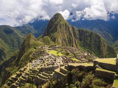
10. We'll finish our tour with the one site everyone just has to see: Machu Picchu, the lost city of the Incas. Abandoned for unknown reasons before the Spanish conquest, it escaped the ravages of war and survives as a stunning example of Incan stonework and urban planning. In the local language (Quechua), what does "Machu Picchu" mean?
Source: Author
CellarDoor
This quiz was reviewed by FunTrivia editor
minch before going online.
Any errors found in FunTrivia content are routinely corrected through our feedback system.
