
FREE! Click here to Join FunTrivia. Thousands of games, quizzes, and lots more!
Reaching a Plateau Trivia Quiz
A plateau is an high geographic area that is relatively flat on the top, and typically formed by glaciers, erosion, volcanoes, or tectonic activity. Come along with me to take a trip around the world in order to reach some plateaus!
A label quiz
by ponycargirl.
Estimated time: 3 mins.
Last 3 plays: turtle52 (10/10), Waldkaeuzchen (7/10), Guest 76 (6/10).
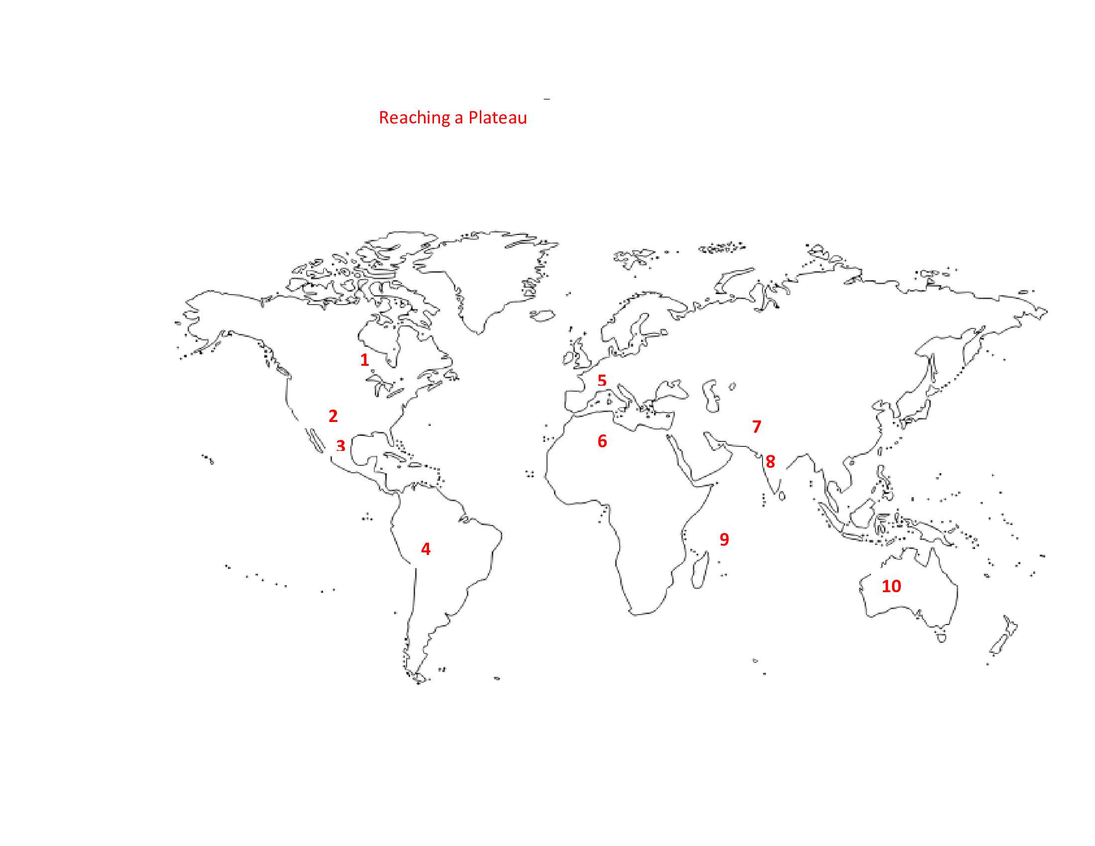
Match the correct plateau with the number on the map.
Click on image to zoom
Tibetan PlateauMascarene PlateauDeccan PlateauMassif CentralAndean PlateauColorado PlateauAhaggar PlateauMexican PlateauLaurentian PlateauWestern Plateau* Drag / drop or click on the choices above to move them to the answer list.
1.
2.
3.
4.
5.
6.
7.
8.
9.
10.
Most Recent Scores
Jan 19 2025
:
turtle52: 10/10
Jan 15 2025
:
Waldkaeuzchen: 7/10
Jan 15 2025
:
Guest 76: 6/10
Jan 12 2025
:
calmdecember: 10/10
Jan 06 2025
:
lones78: 10/10
Dec 15 2024
:
pehinhota: 10/10
Dec 15 2024
:
Guest 174: 5/10
Dec 15 2024
:
Guest 49: 7/10
Dec 10 2024
:
PurpleComet: 10/10
Quiz Answer Key and Fun Facts
1. Laurentian Plateau
Also called the Canadian Shield, the Laurentian Plateau covers approximately 3 million squares miles North America, stretching from the Great Lakes to northwestern Canada and a bit of Greenland. Formed from 2.5 to 4.2 billion years ago, the area was originally covered with high mountains that have since been eroded.
Glaciation during the Ice Age left a very thin layer of soil in some areas that supports boreal forests, in some areas to the south that contain abundant wildlife. In addition, the Laurentian Plateau contains some of the richest mineral deposits in the world, including iron ore, nickel, gold, silver, copper, and diamonds.
2. Colorado Plateau
Most of what is called the Colorado Plateau in the United States was formed sometime between 70-40 million years ago, however, the Colorado River and its tributaries, which cover about 90% of the area, is believed to have begun its erosion process approximately ten million years ago. Surrounded by the Rocky Mountains to the north and east, the Great Basin to the west, and the Sonoran Desert to the south, the plateau covers approximately 130,000 square miles in the area that is known as the Four Corners today; this area includes land in the states of Colorado, New Mexico, Arizona, and Utah.
Located in an area of high desert with a few forests, the main industries in the Colorado Plateau are electrical generation and tourism; much of the region consists of parks that are controlled by the U.S. National Parks System, including the Grand Canyon that is found in the southwest corner. Oil, coal, and uranium are also found there.
3. Mexican Plateau
Located in central and northern Mexico, the Mexican Altiplano, or Mexican Plateau, covers approximately 232,388 square miles. Formed sometime between 250-65 million years ago, it is located between the Sierra Madre Occidental and the the Sierra Madre Oriental Mountain ranges.
A semi-arid region that contains some shrub land and forests, the plateau is considered to be the heartland of Mexico because that is where the majority of its people live and where the main cities are located; in addition the valleys of the plateau contain the best farmland. It also contains one of the largest silver mines in the world.
4. Andean Plateau
The Andean Plateau, also called the Altiplano, Collao, and Bolivian Plateau, is located in Bolivia, Chile, and Peru and is approximately 65,000 square miles in size. Formed in many stages beginning about 16 million years ago, it contains several large cities today, such as La Paz, Bolivia, and Puno, Peru.
Known for earthquakes and seasonal cold temperatures, the area contains rich mineral deposits, such as zinc, silver, and tin. People also make a living by herding animals. Beautiful landscapes, like the Valle de la Luna and Lake Titicaca, are enjoyed by tourists to the region, as well as museums, traditional markets, and archaeological sites.
5. Massif Central
The making of Massif Central began approximately 23 million years ago with geologic uplifting and tilting. Volcanic activity around 5.3-2.6 million years ago also contributed to the shape of the region, which covers about 33,000 square miles in south central France.
It was an area that was difficult to access until the construction of the A75 Motorway, which was completed in December 2010. This explains why there isn't very much industry in the region; agriculture, including the growing of grain crops and cattle and sheep farming, and tourism, are the main economic activities in Massif Central.
6. Ahaggar Plateau
The Ahaggar Plateau is located in the Sahara Desert and includes southeast Algeria, and a bit of Niger and Libya. It covers an area of approximately 210,000 square miles. Scientists believe that the plateau began to form about 300 million years ago, as the result of earthquakes and volcanic eruptions. Actually, the Ahaggar Mountains are located on the top of the plateau, which is covered with lava fields.
Although there isn't much rainfall or vegetation, there are some oases which provide water for nomads, such as the Tuareg, as well as animals like the fennec fox, and Dorcas gazelle. Tourists can visit the Ahaggar National Park, established in 1987, to see exquisite rock formations, native animals, and ancient engravings and paintings.
7. Tibetan Plateau
Also known as the Roof of the World, the Tibetan Plateau is surrounded by the Himalayas to the south, the Kunlun Mountains to the north, and the Qilian Mountains to the northeast. Formed approximately 50 million years ago by the collision of tectonic plates, the Roof of the World covers about 965,300 square miles.
An estimated 40% of the people who live on the Tibetan Plateau are nomads who raise animals, but there is some fertile soil and crops such as barley, wheat, and potatoes are grown. Tourism, which has stimulated the manufacture and trade of handicrafts, is an important industry there.
8. Deccan Plateau
The Deccan Plateau covers an estimated 43% of the interior of India, approximately 163,000 square miles, between the Eastern and Western Ghats, and the Satpura and Vindhya Ranges. About 66 million years ago the plateau began to form due to volcanic eruptions and the subsequent flow of lava.
The precious stone found on the Deccan Plateau attracted invaders throughout its history. Home to an estimated 300 million people, the plateau also contains fertile soil that produces crops like cotton, sugar cane, and rice, and a wealth of minerals, such as coal, uranium, and iron ore.
9. Mascarene Plateau
The Mascarene Plateau, the second largest underwater plateau in the Indian Ocean, is located northeast of the island of Madagascar. It is approximately 44,00 square miles in size, and not completely underwater, as it forms many islands, such as the Seychelles and Mascarene Islands.
Part of the plateau is a fragment of Gondwana, an ancient super continent, formed as it began to break up some 180 million years ago. The other part began forming about 66 million years ago as the result of volcanic activity, and continued to form as recently as 2 million years ago.
10. Western Plateau
The Western Plateau covers about a million square miles, or about 67% of the continent of Australia. Composed of extremely arid land, the area is believed to be what is left of the ancient super continent of Gondwana, which began to separate from Pangea approximately 180 million years ago.
Mining is an important occupation in some areas, where iron ore, gold, coal, diamonds, and other resources are found. There is enough water in other places to support farming grains, such as wheat and barley, and sheep and cattle herding.
This quiz was reviewed by FunTrivia editor agony before going online.
Any errors found in FunTrivia content are routinely corrected through our feedback system.