FREE! Click here to Join FunTrivia. Thousands of games, quizzes, and lots more!
Quiz about Five Hundred Miles from Nowhere

Five Hundred Miles from Nowhere Quiz


This quiz deals with ten inland places in Australia that are hundreds of miles away from anywhere in our large nation. It's the real outback of Australia, not the romantic version.

A photo quiz by Creedy. Estimated time: 4 mins.
  1. Home
  2. »
  3. Quizzes
  4. »
  5. Geography Trivia
  6. »
  7. Australia
  8. »
  9. Australian Outback

Author
Creedy
Time
4 mins
Type
Photo Quiz
Quiz #
368,991
Updated
Dec 03 21
# Qns
10
Difficulty
Easy
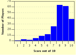
Avg Score
8 / 10
Plays
1424
Awards
Top 20% Quiz
Last 3 plays: oliviat (8/10), Shadman11 (9/10), Guest 58 (8/10).
-
Question 1 of 10
1. Katherine, in the Northern Territory of Australia, began its life as a small settlement in 1872. What was discovered there in 1889 that helped the town develop further? Hint


photo quiz
Question 2 of 10
2. Right in the middle of nowhere in the Northern Territory of Australia is a small town known as Tennant Creek. It is known for its nearby rounded rock formations. What is their diabolical name? Hint


photo quiz
Question 3 of 10
3. Found in the remote south west area of South Australia is one place you wouldn't want to call home. Now known as Oak Valley, which shameful deed was carried out there in the 1950s by an overseas nation? Hint


photo quiz
Question 4 of 10
4. Marree is located in the north of South Australia. It makes the previous town look over-populated. Astonishingly so, this desolate spot was home to a specific building that was the first of its kind in Australia. What was it? Hint


photo quiz
Question 5 of 10
5. Just so you don't become too thirsty taking this dry quiz, we'll now travel down to the more fertile state of Victoria. The town of Horsham there is a lot larger and greener, and is built on the Wimmera River. The original settlers weren't terribly imaginative though. That river has two main tributaries. One is Burnt Creek. What is the other? Hint


photo quiz
Question 6 of 10
6. Wodonga, Victoria, is right on the border with the New South Wales city of Albury. Located a couple of hundred miles away from Melbourne, this city lies on the country's most important river, the Murray. In relation to this river, what first constructed object claims its right to be included in the pages of history? Hint


photo quiz
Question 7 of 10
7. This small area is located almost in the dead centre of Tasmania. One of the coldest non-alpine places in Australia, its aboriginal name is Miena. Based on the pictured clue, what does that name translate to in English? Hint


photo quiz
Question 8 of 10
8. Located 500 miles to the north-west of Sydney, the New South Wales town of Bourke began its life as a result of resistance from the local indigenous people when Europeans first settled there. Most other inland places began with the establishment of a farm or a cattle station. What was Burke's belly button? Hint


photo quiz
Question 9 of 10
9. Barcaldine is a town located smack bang in the central west of Queensland. It is famous for being the birthplace of one of Australia's major political parties, an organisations given birth by the workers of which occupation? Hint


photo quiz
Question 10 of 10
10. Cloncurry is a town in the north-west of Queensland, almost 500 miles away from the next major town. What was discovered there in 1867 which saw the birth of this inland town? Hint


photo quiz

(Optional) Create a Free FunTrivia ID to save the points you are about to earn:

arrow Select a User ID:
arrow Choose a Password:
arrow Your Email:


View Image Attributions for This Quiz

Most Recent Scores
Nov 20 2024 : oliviat: 8/10
Nov 13 2024 : Shadman11: 9/10
Oct 26 2024 : Guest 58: 8/10
Oct 24 2024 : DarkeScampus: 10/10
Oct 06 2024 : Guest 13: 10/10

Score Distribution

quiz
Quiz Answer Key and Fun Facts
1. Katherine, in the Northern Territory of Australia, began its life as a small settlement in 1872. What was discovered there in 1889 that helped the town develop further?

Answer: Gold

Katherine in the Northern Territory is 200 miles from Darwin and 700 miles from Alice Springs. Situated on a small river of the same name, it has a population of just over 6,000 (2011 census figures). When one of Australia's early explorers, John Stuart, came upon the river in 1862 during his sixth exploration of the heart of Australia, he named it after a family member of a friend. By 1872 the first telegraph station had been built there and the town began to grow from that time. It expanded further when gold was discovered thirty miles away in 1889. The mine associated with that find finally closed in 2000.

Katherine's other main claim to fame was that it was bombed by a roving Japanese plane during the Second World War. One person was killed. Today it is the centre for cattle ranchers in the area, stout-hearted farmers, and tourists who pass through on their way up to Darwin and back again. Even with its small population, Katherine is the fourth largest of the settlements in the lonely Northern Territory. It has crocodiles there - big ones - so watch out if you're ever up that way.
2. Right in the middle of nowhere in the Northern Territory of Australia is a small town known as Tennant Creek. It is known for its nearby rounded rock formations. What is their diabolical name?

Answer: Devils Marbles

Tennant Creek lies 600 miles south of Darwin, the capital city of the Northern Territory - and 300 miles north of the navel of Australia, the town of Alice Springs. There is only one highway going north to south through the centre of Australia, so most mileages are estimated from either its beginning at Darwin in the north, its centre at Alice Springs, and its terminus at Port Augusta in South Australia. This is a long, long journey of some 1,800 miles through desert, patches of scrub and endless nothingness. Rest stops, where cars can be re-fuelled and where refreshments are available, are spaced out at approximately 120 mile intervals along this highway. The other smaller rest stops may be located at whatever scenic points are in an area, or just at a table and a rubbish bin plonked in the middle of nowhere.

Tennant Creek, which was known as a rough and tumble centre in its early gold mining days, is today a respectable country town of 3,000 (2011 census figures) sun-burned hardy individuals. Like the previous town, it began in 1860 as a post to link up the overland telegraph centres, and then developed further when gold was discovered in the area in 1926. Today, with one of its mines still operational, this proves to be a major tourism attraction for the area. Cattle grazing is also carried out here on its dry soils. Beef cattle, that is. Dairy cows would well and truly kick the bucket in the heat or the humidity of its summers, or the cold nights of its winters.

To the south of Tennant Creek lies a place of great cultural significance to the area's aboriginal population. Known as Devils Marbles by the white population, or Karlu Karlu by the indigenous people, this is considered to be the oldest religious site in the world. The Devils Marbles are huge rounded granite rock formations found everywhere in this site. Removing any of these enormous rocks from the area is considered to be sacrilegious by the aboriginal people, as was found out in 1952 when one was transported to Alice Springs to form a memorial site there. This caused one hell of a stink, and very rightly so. It is exactly the same as making off with a sacred object belonging to any other religion. The rock was subsequently returned and replaced with another from a non-sacred site, and today the Devils Marbles continue to shine eerily in the moonlight in their very own protected pocket of the globe. Wait - listen - is that thunder? Or is it Old Nick himself playing with his toys?
3. Found in the remote south west area of South Australia is one place you wouldn't want to call home. Now known as Oak Valley, which shameful deed was carried out there in the 1950s by an overseas nation?

Answer: British nuclear tests

The nerve of them letting bombs off in our back yard! ("Order! Order! The protester in the back row will please remove that x-ray machine!").

Most of the massive area of land in this part of Australia goes by the traditional aboriginal name of Maralinga Tjarutja. It has now been graciously handed back to the indigenous people of the same name - from which it was taken in the first place. It really is huge there, measuring almost 40,000 square miles. That's basically 40,000 square miles of nothingness. The centre of this enormous tract of land is a place that goes by the deceptive name of Oak Valley, when there probably isn't an oak to be seen for a hundred miles. It had a population in 2006 of 105 people. That is not a misprint. Oak Valley consists of a few buildings, dirt roads, a few bemused camels (they were imported years ago from overseas), kangaroos desperate to escape, and emus that can kick harder than any footballer ever will.

The Maralinga people were moved from this area in the 1950s to allow Britain to blast it to smithereens in a series of nuclear tests. The lands were then handed back to them in 1985, and its traditional owners finally returned to the area in 1995, trying to re-capture those lost years. Lord bless us, they probably glow in the dark today. I wouldn't live there for quids - but home is where the heart is. And that is their home. They struggled so hard to get back there. It's all just a tiny bit heartbreaking really.
4. Marree is located in the north of South Australia. It makes the previous town look over-populated. Astonishingly so, this desolate spot was home to a specific building that was the first of its kind in Australia. What was it?

Answer: A mosque

Don't be thinking this building was a Hagia Sophia though. It was just a little mud brick construction with a thatched grass roof. Abandoned and left to fall to pieces for years, it has since been restored by an historical society from Broken Hill. It was built originally as a place of worship for the Ghans. These were men from Afghanistan and Pakistan who worked with camels in the far outback in Australia between 1860 and 1930. They first arrived here with a shipment of 24 camels that were used by an early group of explorers (all but one of whom died of thirst and starvation) who had set out, in 1860, to explore Australia from Melbourne, right up to the Gulf of Carpentaria. Following that tragedy, and before the advent of railroads and motor vehicles, camels were subsequently used in the transportation of goods all around our terribly harsh outback. As more Ghans came out to work the camels, a centre of worship was needed to cater to their faith. This was constructed in the early 1880s.

At the same time, Marree - what's left of it, that is - began to grow. This was because it was a planned stop on what was to be the railway link between the north and south of the country's central heart. Its official location is on the corner of the Oodnadatta and Birdsville Tracks. I think that's hilarious. They're two of the most isolated places in the world. Today the whole quarter of the state where Marree is located only has a population of some 600 people, so Marree itself, with a population of 60, is, comparatively speaking, bursting at the seams. For a time there, it seemed that Marree would progress, but then their section of the line was discontinued, and Marree, hot, dry and rejected, began to slowly rust, collapse, and fall to pieces. Any employment generated in this entire area today is from the remaining determined agriculturalists and miners who refuse to be defeated. The biggest structure in the town is the pub, grimly defying the destructive heart of our land to the very last drop.
5. Just so you don't become too thirsty taking this dry quiz, we'll now travel down to the more fertile state of Victoria. The town of Horsham there is a lot larger and greener, and is built on the Wimmera River. The original settlers weren't terribly imaginative though. That river has two main tributaries. One is Burnt Creek. What is the other?

Answer: Burnt Creek Two

Horsham is 200 miles north-west of Melbourne, and the 2006 census reveals it had a population of 14,000 people. That's practically a population explosion for an Australian outback town, considering there is one town back up in South Australia with a population of three. Horsham is located in a relatively dry area, but compared to the other areas visited so far in this quiz, it's practically the Amazon jungle. First settled in 1842, it grew, as so many of our early towns did, from the construction of the life line for our large land - the railway. The line arrived in Horsham in 1879. It was a sorry time for this country when many of those smaller lines began to close down. They took the rural heart of Australia down with them.

Horsham was so advanced at one stage that it even had its own trams - pulled by horses of course. That was back in 1886, but by 1927, the horses had been turned into handbags and the trams no longer ran. Motorcars put them out of business. Horsham continued to progress however. It was declared a town in 1932 and a city in 1949. That's big time for Australia! The huge bushfires that tore through most of southern Australia in 2009 really threatened this delightful area for quite a while. By the time rural fire fighters had them under control, they had burned out 14,000 acres all around Horsham and had hungrily entered the town - no, city - itself. These were followed by huge floods of course, as is the case in our bi-polar land. They took over 600 homes in all. One is inclined to think that memories of past bushfires must have been playing on the minds of the founding fathers of Horsham when they named their life giving water system. Burnt Creek One and Burnt Creek Two certainly don't soar with classical lyricism.
6. Wodonga, Victoria, is right on the border with the New South Wales city of Albury. Located a couple of hundred miles away from Melbourne, this city lies on the country's most important river, the Murray. In relation to this river, what first constructed object claims its right to be included in the pages of history?

Answer: The first bridge built across the Murray

The Murray is the longest river in our nation. Crossing 1,500 miles in all, it rises in the Australian Alps (just hills really - we're basically a flat land) and commences its long journey right through the inland plains of south east Australia. Forming most of the border between the states of New South Wales and Victoria, the Murray finally completes its trip way over in South Australia. Along the way, it links up with our other important river system, the Darling. This river, which is joined by several smaller streams from as far away as Queensland, flows down from the north on its equally long journey, and the large areas both rivers pass through along the way are known as the food bowl of the nation. We have to eat, but oh, sometimes this comes at a dreadful cost to our scarce water resources. If their waters weren't used for massive irrigation purposes today, the Murray, the Darling and the Murray-Darling would probably contain far more water than is currently the case. Because of this however, both are now fairly narrow and shallow, and the Darling, at times, has been known to dry up completely. Way back in their heyday though, both rivers, particularly the Murray, once knew a thriving trade and transport service carried out by stately paddle steamers. Today, just a couple of tourist oriented ones ply parts of the Murray and continue to cling on desperately to the memories of their once glorious past.

Wodonga itself is a large inland city of some 31,000 thousand people, which, when combined with the residents of its rival city of Albury on the opposite bank, caters to an area population of some 80,000. For Australian, that's enormous. Both areas, to the annoyance of their residents, are usually referred to by the rest of Australia as Albury-Wodonga. Founded in 1852, Wodonga was a centre for the bustling cattle industry in the region. Today it is the site of a large army base and university, as well as its many manufacturing industries, ubiquitous football clubs and various other sporting venues. Rather embarrassingly so, it is also home to the world's largest rolling pin. This is a monstrosity stuck on top of a bakery shop there. Wodonga, in 1860, also became known as the city that erected the first bridge to span the might Murray River. I was almost inclined to say "Big deal" when I learned this - but it sure beats the heck out of a giant rolling pin.
7. This small area is located almost in the dead centre of Tasmania. One of the coldest non-alpine places in Australia, its aboriginal name is Miena. Based on the pictured clue, what does that name translate to in English?

Answer: Like a lagoon

Miena is located beside Australia's second largest lake, which goes by the uninspiring name of Great Lake. Truly, the early European settlers who named various sites in our country had all the imaginative abilities of a cucumber. Yet in spite of this alluring stretch of water, and probably because of its location almost in the dead centre of Tassie, this town only has a permanent population of just over 100 people. Tourists come and go, mainly for the fishing in its waters, or just to say they've been there, but otherwise the town's isolation and cold weather probably deters all but the hardiest souls. The area receives such high snowfalls in the middle of our winter, that it is sometimes inaccessible by road, and the lake itself can freeze over with ice at times.

The southern end of the lake, which the local indigenous people once looked upon as a large lagoon, has been dammed to allow for the production of hydroelectricity. The small state of Tasmania is very big on this form of power. Only 225 miles long and 190 miles wide, Tasmania, with its total population of just over 500,000 (2012 figures) is only 26,000 square miles in area. This is smaller that many local government areas on the Australian mainland, yet this valiant little state boasts over 30 hydroelectricity plants and two giant wind farms. They have far more sense down there than in the rest of the nation.
8. Located 500 miles to the north-west of Sydney, the New South Wales town of Bourke began its life as a result of resistance from the local indigenous people when Europeans first settled there. Most other inland places began with the establishment of a farm or a cattle station. What was Burke's belly button?

Answer: A stockade

Aboriginal peoples over most of the vast area of Australia built no villages or permanent structures of habitation. They were nomadic in lifestyle and only stayed in places long enough to use the available resources, before moving on to allow that area to replenish itself naturally. The ones who resided in the Burke area objected to Europeans wanting to muscle in on their territory, and put up a show of resistance. As a result, a stockade was built there in the early 1850s for the new settlers who had started to flow to the area, and the town grew up around it. Somewhat exasperated, I'd like to know who in their right mind would want to move 500 miles away from the capital city in the first place? Moving around the block I can understand - but five hundred miles? In the 1850s? No phones, no roads, no transport, no facilities of any kind? I ask you. Lord bless us, our early settlers were either incredibly brave - or completely insane.

When one of our first explorers first saw the area of Burke, it was in the middle of a drought. He said the area was totally uninhabitable and got out of there as fast as he could. That was in 1828. Seven years later however, they'd had some rain, and a government surveyor recommended the area as a possible centre to set up agricultural enterprises. Situated on the Darling River, when in flow, it probably did seem appealing enough, but our inner heart is always being rent in two by either floods or droughts, so he probably saw it during a happy medium. Today, Burke's population is just over 2,000. Back in the late 1800s it was a thriving community for a while, serviced at that time by horse drawn coaches, camel trains and paddleboat steamers carrying large quantities of trading goods, but when the era of trading by river began to fade, and then disappear altogether, Burke began to follow likewise.

Today this semi-desert like area exists on its sheep industry and small cotton farms. It can be stinking hot in summer, recording in one year for example, summer temperatures over 121 degrees Fahrenheit - but just as cold in winter. And its either in flood or in the middle of a drought. There has been a saying in this country for years, when describing any undesirable location far away from civilisation that it's at the "Back of Burke". It's not a compliment by any stretch of the imagination, but the people of Burke, like most Australians, simply thumb their noses at those who denigrate it. In retort, therefore, today they have cheekily named several of their tourist establishments there as the "Back o' Burke" instead.
9. Barcaldine is a town located smack bang in the central west of Queensland. It is famous for being the birthplace of one of Australia's major political parties, an organisations given birth by the workers of which occupation?

Answer: Shearers

Barcaldine, which is miles away from everywhere, takes its name from a huge sheep station established there in 1863. It had grown large enough to have its own post office (oh happy thought) by 1886, and, to the sorrow of children everywhere, its first school by 1887. In 2006, the population count for this town stood at just over 1,300 people. It's a heart-breaking fact that the savage and lonely, but deeply appealing centre of our nation, has so few to appreciate its wild beauty. Most people born there have to leave to find work in the big coastal cities, yet the true character of our nation, no matter how often I poke fun at it, lies out there in the outback. It creates giants and heroes. It makes us who we are.

So then, how did Barcaldine - pronounced Bar-call-din - become associated with the early head-kicking Labor Party of Australia? (That's how we spell it here, even though we use "labour" for the verb and the noun. This, I might add, is very annoying to a former school teacher). Because the area around Barcaldine was noted for its sheep rearing, Barcaldine subsequently became the focal point for the constantly travelling shearers in search of their next job. Shearing is really hard work even by today's standards, with all the electrical gear used for the job. Back then, it was manual, back-breaking labour. The sheep had to be washed first because the English mill owners who took our wool demanded it be free of soil and burrs. This wasn't because they were particularly fussy toffs, but because washed wool was lighter, so more could be packed into the bales. The shearing work days were long and hard for the men, hot and sweaty, with wriggling animals held firmly between their thighs, and shearing done by hand. And, paid per sheep shorn, the pay was lousy. By 1891, they'd had enough, and, joining other lowly paid and discontented workers in other industries all across the nation, four great Australia wide strikes subsequently followed.

Two of these strikes were by the shearers, brought about by the fact that the sheep owners wanted to reduce their already poor pay. When these strikes were violently broken up by the police and the owners, the men turned to a political solution instead - and the formation of the Australian Labor Party was the result. This is the oldest political party operating in Australia today, still going as strong as ever, and still kicking heads whenever it can, as it strives to bring about the most equitable solutions possible for the poor, the disadvantaged, the unemployed, the aged and the ill members of our country.
10. Cloncurry is a town in the north-west of Queensland, almost 500 miles away from the next major town. What was discovered there in 1867 which saw the birth of this inland town?

Answer: Copper

Cloncurry, whose population is going backwards - just over 2,300 in 2006 - is known as "The Friendly Heart of the Great North-West". That's because it's the only heart of the great north west. Known today as the centre for the large cattle industry in the area, it was founded on the discovery of copper there in 1867. From that early discovery, the Great Australian Mine would subsequently develop, and, like the other mines that followed, this remains a huge open cut scar on the landscape today. Gold was later discovered nearby, and, with the announcement of the construction of a soon to be built railroad (which didn't actually make it there until 1907), Cloncurry was proclaimed a town in 1884. Oh, big deal. That was just a case of overweight politicians, huffing and puffing and sounding important, but actually doing nothing at all beyond saying that a collection of houses and buildings and open cut mines scattered all over the joint was now a town. We really respect our politicians in this country as you may have noticed.

Other matters of interest for which Cloncurry is noted today are the birthplace of the Royal Flying Doctor Service in 1928, and what was thought to be the highest temperature ever recorded in Australia (127 degrees Fahrenheit) in 1889. This however has now been challenged as it's been revealed that the reading was "measured in an improvised screen made from a beer crate". Cloncurry was due to be made Australia's first solar powered city in the early 21st century. However these plans were scrapped in 2012 when the Queensland government withdrew funding for its construction. Yep, we really love our politicians in this country. In the 1950s, the discovery of uranium at a nearby place (relatively speaking) subsequently known as Mary Kathleen was also big news for a time. This area had been sparsely settled since the 1860s, but with the discovery of uranium, the township of Mary Kathleen was built for the purpose of extracting this dangerous substance from the ground. It then became the first township to be totally dismantled when the mine was closed in 1984. Today only roads remain to show a centre of population once thrived there, and the land, so the government informs us all with the sincerity of a ravenous wolf, has been rehabilitated.

On that depressing note, this quiz closes. Australia is a huge, barren, dry land with a dangerous and destructive angry heart. Only half the nation has been covered in these ten questions. West Australia is way too huge to have been also included. Our inland can break hearts, take lives and destroy all hope. It can drive men to drink and women to despair. It is almost always drought ridden, or savaged by mad, uncontrollable bushfires, and, when not in those moods, it's torn apart by raging floods that rip the soil away in large, destructive chunks. And yet...and yet...I've finally come to understand what indigenous people mean when they say "We are the land", something I've never really understood before. Because, you see, we are. We are the land - and I love that land with all my heart.
Source: Author Creedy

This quiz was reviewed by FunTrivia editor Tizzabelle before going online.
Any errors found in FunTrivia content are routinely corrected through our feedback system.
Related Quizzes
This quiz is part of series Australiana 2:

A few more quizzes all related to our beautiful wide brown land, Australia :)

  1. Australian Landmarks Easier
  2. Australian Slang Average
  3. Beach Party with Australians! Easier
  4. De-Myth-tifying Australian Myths Very Easy
  5. Down Under Facts from Australia Average
  6. Early Australian Prime Ministers Average
  7. Five Hundred Miles from Nowhere Easier
  8. Historic Sydney Average
  9. Unique Australian Plants Easier

11/21/2024, Copyright 2024 FunTrivia, Inc. - Report an Error / Contact Us