FREE! Click here to Join FunTrivia. Thousands of games, quizzes, and lots more!
Quiz about Geography undone

Geography un-done Trivia Quiz


A physical look at what our earth can sometimes show. And some of the well known physical aspects of our planet.

A multiple-choice quiz by doomed. Estimated time: 4 mins.
  1. Home
  2. »
  3. Quizzes
  4. »
  5. Geography Trivia
  6. »
  7. Physical Geography

Author
doomed
Time
4 mins
Type
Multiple Choice
Quiz #
138,646
Updated
Dec 03 21
# Qns
10
Difficulty
Tough
Avg Score
6 / 10
Plays
2515
Last 3 plays: Edzell_Blue (8/10), zeljko74 (6/10), sw11 (10/10).
- -
Question 1 of 10
1. What term refers to flat bottomed depression, also known as a "flat" or a "dry lake", found in interior desert basins? Hint


Question 2 of 10
2. Which lake would be considered the headwater of the single drainage system formed by the Great Lakes? Hint


Question 3 of 10
3. What term is given to a narrow strip of land connecting two large land areas otherwise separated by sea? Hint


Question 4 of 10
4. What is a 'RIA'? Hint


Question 5 of 10
5. The source of the Arkansas River is in which mountain range? Hint


Question 6 of 10
6. Along which country's coast is the world's second largest coral reef situated? Hint


Question 7 of 10
7. Where would you find the Qattara Depression? Hint


Question 8 of 10
8. The sea of Azov is an extension of which sea? Hint


Question 9 of 10
9. What is the correct name given to a broad flat bottomed volcanic crater? Hint


Question 10 of 10
10. What is a meander? Hint


(Optional) Create a Free FunTrivia ID to save the points you are about to earn:

arrow Select a User ID:
arrow Choose a Password:
arrow Your Email:


Most Recent Scores
Nov 22 2024 : Edzell_Blue: 8/10
Nov 18 2024 : zeljko74: 6/10
Nov 13 2024 : sw11: 10/10
Nov 12 2024 : Guest 172: 5/10
Nov 12 2024 : Guest 101: 5/10
Nov 11 2024 : ptc123: 7/10
Oct 31 2024 : Guest 151: 4/10

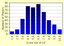
Score Distribution

quiz
Quiz Answer Key and Fun Facts
1. What term refers to flat bottomed depression, also known as a "flat" or a "dry lake", found in interior desert basins?

Answer: Playa

Interior desert basins and adjacent to coasts is where you will find a PLAYA. They are found in arid or semi arid areas which were periodically covered in water that slowly filtrated in to the water system or like most occasion evaporates into the atmosphere, causing salt deposition and that of sand and mud along the bottom of the depression.The word derives from the Spanish for shore or beach and are very flat landforms.
2. Which lake would be considered the headwater of the single drainage system formed by the Great Lakes?

Answer: Superior

The drainage of the lakes roughly empty from west to east in to the Atlantic. Except for Michigan and Huron lakes, their altitudes drop with each lake, usually causing a progressively increasing rate of flow. Superior , bordered by Ontario, the Upper peninsula of Michigan, Wisconsin, and Minnesota, is the most Northern and westernmost lake and can be considered the headwater of the system.
3. What term is given to a narrow strip of land connecting two large land areas otherwise separated by sea?

Answer: Isthmus

The two most famous Isthmuses are the Panama connection of North and South America and the Suez connection of Africa and Asia. Isthmuses are of great importance for the migration of animal species and the growth of plant life.
4. What is a 'RIA'?

Answer: Deep, sunken river valley drowned by the sea

They can be found along rugged coast in line to a mountain chain, many rias were formed by the rise of the sea level after melting of the vast continental glaciers. Rias are commonly very irregular and may have several branching tributaries, they usually are the major drainage systems of the adjacent areas.
5. The source of the Arkansas River is in which mountain range?

Answer: Rocky

The Arkansas river rises in the Sawatch Range of the Rocky Mountains near Leadville in central Colorado and flows southeastward for 2,350km (1,460 miles) through Kansas, Oklahoma and Arkansas before it enters its tributary the Mississippi. It also enters Mississippi 64 km (40 miles) northeast of Arkansas City.

It has a total fall of 3,475m (11,400ft) and its drainage basin covers 417,000 sq km(161,000 sq miles).
6. Along which country's coast is the world's second largest coral reef situated?

Answer: Belize

Second to the Great Barrier Reef of Australia and the largest of its kind in Northern and Western hemispheres. It extends for more than 290 km (180 miles) along the Caribbean coast of Belize. It maintains an offshore distance ranging from about 300m (1,000 ft) in the north to 40km (25 miles) in the south except at Rocky point which it meets wit ht the shoreline.
7. Where would you find the Qattara Depression?

Answer: Egypt

The Qattara depression can be found in the arid Libyan Desert (East Saharan) basin in Northwest Egypt. It covers around 18,100 sq km (7,000 sq miles) and contains salt lakes and marshes. It descends to 133m(435ft) below sea level. In the late 1970s oil deposits were discovered in the southern part of the depression.
8. The sea of Azov is an extension of which sea?

Answer: Black Sea

Situated off the southern shores of Ukraine and Russia the Sea of Azov is an island sea. It forms a northern extension of the Black Sea to which it is linked on the south by the Kirch strait. The Sea of Azov is about 340km (210 miles) long and 135km (85 miles)wide and has an area of about 37,600sq km (14,500 sq miles).
9. What is the correct name given to a broad flat bottomed volcanic crater?

Answer: Caldera

A large bowl shaped depression reaching diameters of 1km (0.6 miles) distances and rimmed with infacing scarps. Calderas are often if not always, formed by the collapse of the top of a volcanic cone or group of cones because of removal of the support formerly furnished by an underlying body of molten rock (magma).
10. What is a meander?

Answer: Bend in river or stream

An extreme U-bend in a stream, usually occurring in a series, meanders are most often formed in alluvial materials (stream deposited sediments) and thus freely adjust their shapes and shift downstream according to the slope of the alluvial valley.
Source: Author doomed

This quiz was reviewed by FunTrivia editor minch before going online.
Any errors found in FunTrivia content are routinely corrected through our feedback system.
11/23/2024, Copyright 2024 FunTrivia, Inc. - Report an Error / Contact Us