FREE! Click here to Join FunTrivia. Thousands of games, quizzes, and lots more!
Quiz about Pining For the Fjords

Pining For the Fjords Trivia Quiz


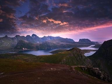
This quiz is about Norway, a country known for its fjords, not the classic Monty Python 'Dead Parrot' sketch (which is well worth a look, too).

A photo quiz by looney_tunes. Estimated time: 4 mins.
  1. Home
  2. »
  3. Quizzes
  4. »
  5. Geography Trivia
  6. »
  7. Europe
  8. »
  9. Norway

Author
looney_tunes
Time
4 mins
Type
Photo Quiz
Quiz #
360,047
Updated
Dec 03 21
# Qns
10
Difficulty
Average
Avg Score
8 / 10
Plays
2992
Awards
Top 5% quiz!
Last 3 plays: shvdotr (8/10), OswaldEllie (10/10), Debarrio (7/10).
-
Question 1 of 10
1. Norway is renowned for its fjords. Exactly what was responsible for creating them in the first place? Hint


Question 2 of 10
2. What is noteworthy about Sognefjord? Hint


Question 3 of 10
3. What is the name of the peninsula shown here, on which Norway is located? Hint


Question 4 of 10
4. With which of these countries does Norway NOT share a land border? Hint


Question 5 of 10
5. Jan Mayen is a volcanic island about 1,000 km off the coast of Norway in the North Atlantic. As you can see from this satellite image, it has two larger parts connected by an isthmus. The northern part contains the world's northernmost active surface (as opposed to submarine) volcano. What is its name? Hint


Question 6 of 10
6. The northernmost point of Norway is found in an archipelago located in the Arctic Ocean which was first settled in the 17th century as a base for an economically important industry. The collapse of what industry in the 19th century led to the temporary abandonment of Svalbard? Hint


Question 7 of 10
7. Bouvet Island is an uninhabited Norwegian dependency in the South Atlantic which is an important breeding ground for what kind of bird? Hint


Question 8 of 10
8. Norway has a sizable claim in Antarctica (although no Antarctic claims are officially recognised). What is the name they give to the region to which they lay claim? Hint


Question 9 of 10
9. This is a picture of Norway's oldest national park (although its name suggests it might be located in another nearby country), which was established in 1962 and is renowned for its reindeer. What is its name? Hint


Question 10 of 10
10. Since 1979 this dock area in Bergen has been a UNESCO Cultural Heritage site, because the buildings were an important part of the Hanseatic League. What is this region called? Hint


(Optional) Create a Free FunTrivia ID to save the points you are about to earn:

arrow Select a User ID:
arrow Choose a Password:
arrow Your Email:


View Image Attributions for This Quiz

Most Recent Scores
Dec 20 2024 : shvdotr: 8/10
Dec 20 2024 : OswaldEllie: 10/10
Dec 20 2024 : Debarrio: 7/10
Dec 19 2024 : bradez: 6/10
Dec 17 2024 : rustic_les: 10/10
Dec 13 2024 : Trivia_Fan54: 8/10
Dec 12 2024 : Guest 165: 8/10
Dec 02 2024 : hosertodd: 8/10
Nov 30 2024 : FrappMaster: 10/10

Score Distribution

quiz
Quiz Answer Key and Fun Facts
1. Norway is renowned for its fjords. Exactly what was responsible for creating them in the first place?

Answer: Glaciers

A fjord is a long, narrow inlet of the sea, usually with steep sides. The sea water is filling a valley left behind when a glacier covering the area retreated. The glacier's load of rocks (which it had collected as it grew larger) scraped on the underlying ground, and softer materials were eroded to leave valleys, separated by ridges of harder material, which then filled with sea water. Because of the geologic changes in the crust that are involved in this process, fjords are often significantly deeper than the sea level offshore from the coast.

The entrance to the fjord, however, is usually relatively shallow, as it is the site where the terminal moraine (the pile of rocks the glacier was pushing ahead of itself as it expanded) was deposited.
2. What is noteworthy about Sognefjord?

Answer: It is the longest fjord in Norway

At 205 km (125 mi), Sognefjord is over 25 km longer than its nearest rival, Hardangerfjord. Located in the Sogne region, it has a number of branches, many with their own name, before it officially terminates near the small village of Skjolden. Where it meets the sea, it is only 100m deep, but the middle part of the fjord is over 1300m below sea level, surrounded by cliffs of up to 1,000m. Skjolden is located near the Jostedal Glacier, the largest glacier on the European continent. Skjolden is also one of the access points to Jotunheimen National Park, whose name means "Home of the Giants".

It is famed for its fantastic fishing and hiking, as well as its wildlife - this is a great spot to photograph reindeer, elk and lynx.
3. What is the name of the peninsula shown here, on which Norway is located?

Answer: Scandinavian Peninsula

The Scandinavian Peninsula is often said to be the largest peninsula in Europe, but there is a certain amount of debate as to exactly what land areas one includes in the various peninsulas. Nevertheless, it is very large, with an area of around 750,000 sq km. This makes it bigger than Texas, and about the same size as Chile or Zambia.

The name of the peninsula comes from Scania, its southernmost tip, which has at various times belonged to Denmark and Sweden (of which it is currently a part). The term Scandinavian is used to describe the common cultural heritage of Norway, Sweden and Denmark.

The Iberian Peninsula, in southwestern Europe, is the location of Spain and Portugal. The Balkan Peninsula, in southeastern Europe, includes a number of countries including Greece, Macedonia and Bulgaria. The Jutland Peninsula is in the north of Europe; its southern part belongs to Germany, while the northern part is Danish.
4. With which of these countries does Norway NOT share a land border?

Answer: Denmark

Sweden and Norway make up most of the Scandinavian Peninsula, with the Scandinavian mountain range defining most of the border between Norway on the west and Sweden on the east. The northern part of Norway has shorter borders with Finland (about 700 km) and Russia (about 200 km). Norway shares a maritime border with Denmark, because they are separated by the Skagerrak Strait, a branch of the North Sea. Most of Norway's coastline is on the Norwegian Sea, with the Barents Sea on the north end, and the North Sea on its southern coast. Yes, the southern coast - that's how far north it is!
5. Jan Mayen is a volcanic island about 1,000 km off the coast of Norway in the North Atlantic. As you can see from this satellite image, it has two larger parts connected by an isthmus. The northern part contains the world's northernmost active surface (as opposed to submarine) volcano. What is its name?

Answer: Beerenberg

Beerenberg, the glacier-capped volcano clearly seen in the satellite image, received its name from Dutch whalers who spotted polar bears on its slopes. In Dutch, the name means Bear Mountain. It has erupted a number of times in recorded history, most recently in 1985. All 20th century eruptions involved flank eruptions - lava breaking through cracks in the sides of the volcano.

There are a lot of small cinder cones on the sides of the main cone marking the sites of such eruptions.
6. The northernmost point of Norway is found in an archipelago located in the Arctic Ocean which was first settled in the 17th century as a base for an economically important industry. The collapse of what industry in the 19th century led to the temporary abandonment of Svalbard?

Answer: whaling

The islands of the Svalbard archipelago are a part of Norway, despite being located well offshore - they are about halfway between the northernmost point of mainland Norway and the North Pole. The largest island, Spitsbergen, was an important whaling base in the 17th and 18th centuries, but whaling died out during the 19th century.

The islands then became a popular starting point for Arctic exploration groups, and coal was discovered around the start of the 20th century. Coal mining continues, but two thirds of the surface area of the archipelago has been protected as national parks and national reserves, protecting the polar bears and reindeer which are a popular tourist attraction.
7. Bouvet Island is an uninhabited Norwegian dependency in the South Atlantic which is an important breeding ground for what kind of bird?

Answer: Penguins

Bouvet Island, located at the southern end of the mid-Atlantic ridge, is a volcanic island that is a significant breeding ground for many species of birds, but the penguin is the only one listed which is found in the area. Macaroni penguins are the most common species of penguin, followed by chinstrap and Adelie penguins. Several species of petrel and tern also breed there, leading to the island's designation as an Important Bird Area by BirdLife International.
8. Norway has a sizable claim in Antarctica (although no Antarctic claims are officially recognised). What is the name they give to the region to which they lay claim?

Answer: Queen Maud Land

Queen Maud Land lies between Coats Land and Enderby Land, in a wedge shape that runs down towards the South Pole. George V Land is on the opposite side of the Antarctic continent. While there is no permanent population in the territory, there are twelve active research stations, six of which are manned all year. Troll is the only Norwegian all-year research station; the others are staffed by scientists from other countries.

The airfield at Troll is used by all the stations in the region. Although Queen Maud Land was one of the first parts of Antarctica to be sighted by European explorers, it was one of the last to be explored, due to the difficulty of the terrain.
9. This is a picture of Norway's oldest national park (although its name suggests it might be located in another nearby country), which was established in 1962 and is renowned for its reindeer. What is its name?

Answer: Rondane

Rondane National Park is located in the counties of Oppland and Hedmark, and covers nearly 1000 sq km. The most significant species to be found there is reindeer. It has ten peaks of over 2,000 m, most of which can be easily reached from the central Rondvatnet Lake. The terrain is arid, and supports little vegetation - the reindeer forage off the lichen and moss, along with some small amounts of grass.

The other three national parks were all established in the 21st century.
10. Since 1979 this dock area in Bergen has been a UNESCO Cultural Heritage site, because the buildings were an important part of the Hanseatic League. What is this region called?

Answer: Bryggen

Bryggen is Norse for wharf, and the Bryggen was the important wharf area for trade during the time of the Hanseatic League, a commercial alliance that flourished between the 13th and 17th centuries. Bergen was established in 1070, and what is now called the Bryggen represents the oldest part of the city. Fire has been a constant threat to the wooden buildings, and few of the contemporary buildings date back as far as 1702, the time of a great wharf fire. Following a fire in 1955, restoration included the construction of the Bryggen Museum, which includes the buildings shown in the photo.
Source: Author looney_tunes

This quiz was reviewed by FunTrivia editor Pagiedamon before going online.
Any errors found in FunTrivia content are routinely corrected through our feedback system.
Related Quizzes
This quiz is part of series My Adventures in Authoring:

The Adventures in Authoring poses a series of opportunities for authors to extend themselves into new areas of quiz writing. These are some of the products of my Adventure.

  1. 9 for 10 from Down Under Easier
  2. Melbourne Cup Day Night Easier
  3. I Write the Songs Easier
  4. Come on Down Easier
  5. Step Up and Play Easier
  6. What Came Before 'Lord of the Rings'? Easier
  7. Poems From my Childhood Average
  8. Gold! Gold! Gold! Average
  9. Babe Average
  10. Fungi, New and Mold Easier
  11. Across All Micronesia Average
  12. Going Against the Grain Average

Also part of quiz list
12/22/2024, Copyright 2024 FunTrivia, Inc. - Report an Error / Contact Us