FREE! Click here to Join FunTrivia. Thousands of games, quizzes, and lots more!
Quiz about Water under the Rising Sun

Water under the Rising Sun Trivia Quiz


Many cities in Japan sound familiar throughout the world. However, what do you know about Japanese rivers, lakes and bays?

A multiple-choice quiz by JanIQ. Estimated time: 5 mins.
  1. Home
  2. »
  3. Quizzes
  4. »
  5. Geography Trivia
  6. »
  7. Asia
  8. »
  9. Japan

Author
JanIQ
Time
5 mins
Type
Multiple Choice
Quiz #
362,799
Updated
Dec 03 21
# Qns
10
Difficulty
Average
Avg Score
8 / 10
Plays
2460
Awards
Top 10% Quiz
Last 3 plays: hellobion (10/10), robbonz (8/10), imustac (8/10).
- -
Question 1 of 10
1. The northernmost of the main islands of Japan is Hokkaido. This island is also a region with the capital city Sapporo. Which river is quite nearby? Hint


Question 2 of 10
2. We go to the north of the island Honshu. Fukushima, the site of the nuclear disaster in 2012, is situated on the Abukuma River. Which of the following lakes is less than 80 km (50 miles) from Fukushima? Hint


Question 3 of 10
3. Let's stay in Honshu for a while. Just south of Tokyo is a Japanese prefecture with the regional capital city Yokohama. What is the name of this prefecture, a name you will perhaps recognise as the location that inspired Katsushige Hokusai to depict a great wave? Hint


Question 4 of 10
4. The Shinano River, the longest river in Japan, flows through the Niigata Prefecture in the west of the island Honshu. Into which sea does the Shinano River mouth? Hint


Question 5 of 10
5. Still in the island Honshu, we find the city of Osaka, which is served by the international airport Kansai. What is special about this airport? Hint


Question 6 of 10
6. We continue our travel through the prefectures on the island Honshu, and reach Hiroshima. I chose a very peaceful destination in this prefecture: the Itsukushima Shrine on the small island Miyajima. What is the most typical feature of this world famous shrine? Hint


Question 7 of 10
7. The last prefecture on Honshu I'll visit in this quiz is Yamaguchi. One of the most interesting places in this prefecture is the Kintai Bridge over the river Nishiki, near the town of Iwakumi. This specific location attracts myriads of Japanese in the month of April, in order to participate in the practice of hanami. What kind of festive activity is hanami? Hint


Question 8 of 10
8. The island Shikoku has only four prefectures. The one we'll visit here is the prefecture of Tokushima, and more specifically the shore near Naruto city. Which natural phenomenon can be observed over here several times a day? Hint


Question 9 of 10
9. Japan consists of four main islands, of which Kyushu is the one that lies the most to the southwest. Which prefecture on Kyushu lies on Tsushima Strait, which separates Japan from South Korea? Hint


Question 10 of 10
10. The four main islands of Japan are Hokkaido, Honshu, Shikoku and Kyushu. There is only one Japanese prefecture, which is not situated on one of these four main islands. Which prefecture is based in the Ryukyu island chain? Hint


(Optional) Create a Free FunTrivia ID to save the points you are about to earn:

arrow Select a User ID:
arrow Choose a Password:
arrow Your Email:


Most Recent Scores
Nov 14 2024 : hellobion: 10/10
Oct 31 2024 : robbonz: 8/10
Oct 31 2024 : imustac: 8/10
Oct 31 2024 : 173Kraut: 9/10
Oct 31 2024 : Triviaballer: 10/10
Oct 31 2024 : dee1304: 6/10
Oct 31 2024 : kstyle53: 10/10
Oct 31 2024 : rooby2s: 7/10
Oct 31 2024 : Rizeeve: 10/10

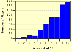
Score Distribution

quiz
Quiz Answer Key and Fun Facts
1. The northernmost of the main islands of Japan is Hokkaido. This island is also a region with the capital city Sapporo. Which river is quite nearby?

Answer: Toyohira

From the centre of Toyohira River to the town centre of Sapporo, you can walk on foot - it is about 20 minutes at a steady pace.

Sapporo and the Toyohira River are situated in the large plain of Ishikari, a geological feature that is very rare in Japan. Most of Japan is so mountainous and divided by rivers that it was quite unpractical (until the late nineteenth century) to use vehicles on wheels.

Sapporo was established around 1868, and is thus a relatively recent city. The architects who designed the city chose for the grid plan. To keep the traffic incidents as low as possible, there are many traffic lights. For instance: if you walk from the centre of Toyohira River to the centre of Sapporo (about 1.7 km or just over one mile), you encounter no less than nine traffic lights.

The Yangtze (Blue River) is one of the two main Chinese rivers. The Mekong (Red River) flows through (among others) Thailand and Vietnam. The Darling is one of the longest Australian rivers.
2. We go to the north of the island Honshu. Fukushima, the site of the nuclear disaster in 2012, is situated on the Abukuma River. Which of the following lakes is less than 80 km (50 miles) from Fukushima?

Answer: Lake Inawashiro

Did you pick Lake Inawashiro? Well done, it is the only Japanese lake in this list - although the other may sound Japanese too.

Lake Inawashiro is situated south of Mount Bandai, in the middle of Fukushima Prefecture. The city of Fukushima (with the nuclear plant) is to the Northeast of Lake Inawashiro. The lake is one of the largest Japanese lakes, and migrating swans rest on the shores of the lake when they travel. The official website of Inawashiro village (next to the eponymous lake) shows some pretty pictures of the lake and the environment.

Lake Matano is situated in Indonesia, and Lake Paranoara is in Brazil. Lake Tsimanampetsotsa is in Madagascar, as some of you may have guessed from the name.
3. Let's stay in Honshu for a while. Just south of Tokyo is a Japanese prefecture with the regional capital city Yokohama. What is the name of this prefecture, a name you will perhaps recognise as the location that inspired Katsushige Hokusai to depict a great wave?

Answer: Kanagawa

Katsushige Hokusai (1760-1849) was a Japanese woodblock artist. His woodcut "The Great Wave off Kanagawa" is a very famous and powerful scene. I'm convinced you'll have seen this print before.

The prefecture is named after the locality (merged into Yokohama in 1901) where the USA and Japan signed in 1854 the so-called "Treaty of Peace and Amity", in which the USA forced Japan to open commercial relations. At that time, Kanagawa was a small settlement on the Tokaido - the main road between Edo (now called Tokyo), where the secular powers (including the Shogun) resided, and Kyoto, the city with the religious leaders and the Imperial Family.

Kanagawa gained the status of a town in 1889, and merged into Yokohama twelve years later. Today it is one of the 18 wards (districts) of Yokohama, with a strong industrial presence.

Sekigahara is a small town in Gifu Prefecture, in the centre of the island Honshu. It was the site of a great battle in 1600.

Kami is the common Japanese name for Shinto beings (sometimes translated as divine creatures, sometimes as spirits). Although the human eye cannot perceive Kami, the Shinto followers believe the presence and actions of these beings are most important.

Origami is the Japanese craft of paper folding.
4. The Shinano River, the longest river in Japan, flows through the Niigata Prefecture in the west of the island Honshu. Into which sea does the Shinano River mouth?

Answer: Sea of Japan

The Shinano River flows from Mount Kobushi (in Nagano prefecture) towards the city of Niigata, where it empties into the Sea of Japan. The Sea of Japan separates Russia and the Korean peninsula from Japan.

The Bering Sea does not border Japan, it separates the Russian peninsula Sakhalin from the North-American coastline. The Sea of Okhotsk is situated north of Hokkaido. The East China Sea is southwest of Kyushu.
5. Still in the island Honshu, we find the city of Osaka, which is served by the international airport Kansai. What is special about this airport?

Answer: It is located on an artificial island

The first airport in Osaka is completely surrounded by homes and offices. Therefore, there was no room for any expansion, so the decision was made to build an artificial island on which to create a new international airport. The previous one was closed for international flights and only has domestic movements. Construction began in 1987 and the airport opened in 1994.
The International Date Line is nowhere near Japan. The closest distance from Japan to the date line is about 3,000 km.

Technically, UNESCO could select an airport as World Heritage Site. However, in the first forty-odd years of this project, no airport has been selected.

The international airport at the highest altitude is not in Japan. Two Chinese airports and one in Bolivia are located at an altitude of over 4,000 m (13,000 feet) above sea level.
6. We continue our travel through the prefectures on the island Honshu, and reach Hiroshima. I chose a very peaceful destination in this prefecture: the Itsukushima Shrine on the small island Miyajima. What is the most typical feature of this world famous shrine?

Answer: Its gate seems to be flooded at high tide

Itsukushima is dedicated to the three daughters of Susano-o Mikoto, the kami (Shinto spirit) responsible for the seas and the storms. To honour this kami, the gate is placed on a pier over the water, so that only the upper half of the gate can be perceived at high tide. The gate then seems floating around over the waves.

The picture of the gate at high tide, seen from the temple, is world famous. The UNESCO has selected the shrine as a World Heritage Site, and tourist guides claim the shrine is one of the top sites to visit in Japan.

The red herrings are false in many regards.
One of the most intriguing consequences of the desire for purity in and around the shrine is an absolute interdiction on birth and death. Pregnant women, who are nearing the time of delivery, should leave the island immediately, as well as anyone gravely ill. The island does not have any funeral facilities, either.
The Itsukushima Shrine is made out of camphor wood (not oak), in order to resist the humid environment. The gate and all of the supporting woodblocks in the temple facility are painted bright red, with a paint that can withstand humidity and wind erosion.

Pilgrims collect shellfish at low tide, and put coins in the cracks of the pier. They believe these traditions will bring them good fortune. There isn't any tradition that involves pineapples on the island Miyajima.
7. The last prefecture on Honshu I'll visit in this quiz is Yamaguchi. One of the most interesting places in this prefecture is the Kintai Bridge over the river Nishiki, near the town of Iwakumi. This specific location attracts myriads of Japanese in the month of April, in order to participate in the practice of hanami. What kind of festive activity is hanami?

Answer: Watching the cherry blossoms

Iwakumi is a port city on the southwest of Honshu. The Kintai Bridge is a wooden bridge over five pillars, near a nice stretch of cherry trees. People come and have a party under the cherry trees, mostly in daylight but sometimes even after sunset (with the use of paper lanterns).

The practice of hanami (cherry blossom viewing) goes back over twelve centuries. In the early years, people used to watch the blossoming plum trees, but nowadays the cherry blossoms attract more visitors. There are still people who like to watch the plum blossoms, but that's a minority.

A similar practice is in the autumn, when groups of Japanese travel to find the most beautiful autumnal scenery, when the maples and other deciduous trees take various reddish colours.

Dancing under the midsummer night's sun is a Scandinavian habit in mid-June.
Spooking around with lit pumpkins is typically related to Halloween (October 31). The mistletoe business is connected to the Christmas season.
8. The island Shikoku has only four prefectures. The one we'll visit here is the prefecture of Tokushima, and more specifically the shore near Naruto city. Which natural phenomenon can be observed over here several times a day?

Answer: Whirlpool

Naruto is situated near a sea strait where the Pacific Ocean connects to the Seto inland sea and the Harima-nada Sea. The Pacific waters are subject to large tidal differences, and they force their way into or out of the Harima-nada Sea by a relatively narrow waterway. Indeed, Naruto Strait is only 1.3 km wide. As the height differences between high tide and low tide are at least 1.5 meter, the pressure to flood into or out of the Haruma-nada Sea can mount quite a lot. As a result tidal whirlpools occur, almost four times a day (the whirlpools may be innocuous at slack tide).

The Southern Cross is a constellation only visible from a point in the Southern Hemisphere. Sun shower (rain and sunshine at the same time) and rainbows are relatively rare phenomena. A double rainbow is even more exceptional.
9. Japan consists of four main islands, of which Kyushu is the one that lies the most to the southwest. Which prefecture on Kyushu lies on Tsushima Strait, which separates Japan from South Korea?

Answer: Nagasaki

Of the options mentioned here, only Nagasaki is still a prefecture of Japan. The red herrings were former prefectures, which Japan had to cede immediately after World War II.

Nagasaki prefecture consists of a peninsula on the northwest of Kyushu, as well as several islands. The capital city (Nagasaki) has been devastated by an A-bomb in August 1945, but has since been completely rebuilt.

In the seventeenth century, Nagasaki was the most prominent region for Roman-Catholic missionaries from Portugal and Spain. Many daimyo converted to Christianity, but about 1637 the Shogun banned all foreigners and interdicted foreign religions.

Tsushima Strait, which separates Nagasaki prefecture from South Korea, was the site of the major victory of the Japanese fleet against Russia in 1905.
Tainan was a former Japanese prefecture ceded to Taiwan.

Kankyo-Hoku, a former Japanese prefecture, was ceded to North Korea and is now called North Hamgyong.

Keisho-Nan, yet another former Japanese prefecture, was ceded to South Korea and now carries the name South-Gyeongsang.
10. The four main islands of Japan are Hokkaido, Honshu, Shikoku and Kyushu. There is only one Japanese prefecture, which is not situated on one of these four main islands. Which prefecture is based in the Ryukyu island chain?

Answer: Okinawa

The Ryukyu islands are sixty-odd volcanic islands to the southwest of Kyushu, in the direction of Taiwan, and this over a distance of more than 500 km. Japanese people may object to the use of the name Ryukyu, which refers to an ancient kingdom once established on these islands. In Japanese various names are used (among others Nansei Islands, Okinawa Islands and Nanto Islands), all with their specific pros and cons.

The largest of the Ryukyu Islands is Okinawa, the site of the last major invasion in the Pacific theatre of World War II. (This fact inspired me to pick the red herrings in this question).

Okinawa and the surrounding islands are considered the birthplace of karate. The local authorities banned all weapons around 1450, in a period when the danger from robbers was quite large. So people learned techniques of unarmed combat, and by the end of the Nineteenth century a handful of karate schools emerged.
Source: Author JanIQ

This quiz was reviewed by FunTrivia editor Pagiedamon before going online.
Any errors found in FunTrivia content are routinely corrected through our feedback system.
Related Quizzes
1. Fran in Japan Average
2. An American In Japan Average
3. Features of Life in Japan Tough
4. Japanese Life Style Average
5. Japanese Ts Average
6. Locating Japan Easier
7. Hokkaido Tough
8. Life in Japan Tough
9. Use Your Noodle! Average
10. Prefectures of Japan - Where are You? Average
11. Japanese Cities in the Four Main Islands Easier
12. The Islands of Japan Very Easy

12/21/2024, Copyright 2024 FunTrivia, Inc. - Report an Error / Contact Us