FREE! Click here to Join FunTrivia. Thousands of games, quizzes, and lots more!
Quiz about Where Am I United States Edition

Where Am I?: United States Edition Quiz


Join me on a quest to find ten locations in the United States.

A multiple-choice quiz by bernie73. Estimated time: 4 mins.
  1. Home
  2. »
  3. Quizzes
  4. »
  5. Geography Trivia
  6. »
  7. USA

Author
bernie73
Time
4 mins
Type
Multiple Choice
Quiz #
385,300
Updated
Dec 03 21
# Qns
10
Difficulty
Average
Avg Score
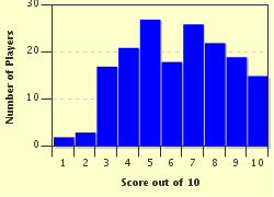
7 / 10
Plays
650
- -
Question 1 of 10
1. I am standing at 38° 56' 55" N, 76° 18' 54" W. I am on an island, the largest one in the Chesapeake Bay. To the west of me a long bridge stretches to the Western Shore of Maryland. Where am I? Hint


Question 2 of 10
2. I am standing at 39°50'N, 98°35'W, northwest of the town of Lebanon. I am standing at a marker placed within half of a mile of what was determined to be the geographic center of the 48 contiguous states. In which Midwestern state am I? Hint


Question 3 of 10
3. I am standing at 47° 13' 5" N, 95° 12' 26" W. I am on the shore of Lake Itasca which is popularly considered to be the headwaters of an important US river. Which river is it? Hint


Question 4 of 10
4. I stand at 41° 10' 0" N, 112° 35' 0" W. In front of me is a lake that in prehistoric times was part of Lake Bonneville. A city and state capital lies to the southeast of the lake. Which lake is this? Hint


Question 5 of 10
5. I travel to 35° 45' 53.42" N, 82° 15' 54.44" W. I am standing at an elevation of 6,684 feet on Mount Mitchell. In which state am I located? Hint


Question 6 of 10
6. I am at 30° 6' 33" N, 93° 45' 33" W. I am standing near mile marker 880 on an Interstate Highway. In which state am I located? Hint


Question 7 of 10
7. I am at 44° 35' 25" N, 104° 42' 55" W. I am standing at the base of a natural monolith that looks very familiar. I think I saw it before in "Close Encounters of the Third Kind" (1977). In which state am I? Hint


Question 8 of 10
8. I am at 38° 42' 28.8" N, 77° 5' 9.96" W. I am at the entrance to the home of a former US President, only a short drive southeast from the capital of the United States. In which Presidential home am I?
Hint


Question 9 of 10
9. I am at 40° 34' 34.61" N, 74° 8' 41.42" W. I am in one of the five boroughs of New York City--the one that, according to a 2015 population estimate, is the least densely populated and third largest. Which borough is this? Hint


Question 10 of 10
10. I am standing at 36°59'56.3"N 109°02'42.6". This is known as Four Corners, the one area of the United States where four US states meet. Which is not one of those four states? Hint


(Optional) Create a Free FunTrivia ID to save the points you are about to earn:

arrow Select a User ID:
arrow Choose a Password:
arrow Your Email:


Most Recent Scores
Dec 18 2024 : Luckycharm60: 10/10
Nov 07 2024 : Guest 71: 10/10

Score Distribution

quiz
Quiz Answer Key and Fun Facts
1. I am standing at 38° 56' 55" N, 76° 18' 54" W. I am on an island, the largest one in the Chesapeake Bay. To the west of me a long bridge stretches to the Western Shore of Maryland. Where am I?

Answer: Kent Island

Covering 31.62 miles, Kent Island sits at the narrowest area of the Chesapeake Bay. From Kent Island to Sandy Point on the western shore is about four miles. Part of Maryland's Queen Anne's County, Kent Island was also the location of the first attempt by the English to establish a colony in what is now Maryland.

At various times, farming and fishing formed important parts of Kent Island's economy. As for the other three choices, Block Island is part of Rhode Island. Jekyll Island lies off the coast of Georgia. Long Island is part of New York and lies off the coast of Connecticut.
2. I am standing at 39°50'N, 98°35'W, northwest of the town of Lebanon. I am standing at a marker placed within half of a mile of what was determined to be the geographic center of the 48 contiguous states. In which Midwestern state am I?

Answer: Kansas

This position was determined in 1918 by the United States National Geodetic Survey in 1918. The actual point is about half a mile away on private property. North Dakota is the geographic center of the United States if we are considering the 50 states (including Alaska and Hawaii). Lebanon, Kansas is about 12 miles south of the Kansas-Nebraska border. Near the marker (erected in 1940) is a picnic area and a small chapel.
3. I am standing at 47° 13' 5" N, 95° 12' 26" W. I am on the shore of Lake Itasca which is popularly considered to be the headwaters of an important US river. Which river is it?

Answer: Mississippi River

Lake Itasca, lying in northern Minnesota, covers about 1.8 square miles. The area around it was made a state park in 1891. The lake was named such by geographer Henry Schoolcraft, who identified it as the headwaters of the Mississippi in 1832. The Mississippi River flows through or borders ten US states on its 2,320 mile course to the Gulf of Mexico.
4. I stand at 41° 10' 0" N, 112° 35' 0" W. In front of me is a lake that in prehistoric times was part of Lake Bonneville. A city and state capital lies to the southeast of the lake. Which lake is this?

Answer: Great Salt Lake

The size of the Great Salt Lake fluctuates but averages around 1,700 square miles. It is the largest US lake outside of the Great Lakes region. With water evaporation being the only outflow from the lake, the waters have a much higher than average salinity.

Despite the saline levels, a wide variety of wildlife lives in or near the lake. Lake Tahoe lies on the border of Nevada and California. Lake St. Clair lies between Lakes Huron and Erie. Lake Okeechobee lies in Florida.
5. I travel to 35° 45' 53.42" N, 82° 15' 54.44" W. I am standing at an elevation of 6,684 feet on Mount Mitchell. In which state am I located?

Answer: North Carolina

Mount Mitchell is located in Yancey County in western North Carolina. Located in the Appalachian Mountains, Mount Mitchell is the tallest mount in the United States east of the Mississippi River. A road and trail leads from the Blue Ridge Parkway to the summit of Mount Mitchell.

A spruce-fir forest covers the summit. The mountain is named for Elisha Mitchell, a professor from the University of North Carolina, who first visited the region in 1835.
6. I am at 30° 6' 33" N, 93° 45' 33" W. I am standing near mile marker 880 on an Interstate Highway. In which state am I located?

Answer: Texas

Texas is the second largest of the 50 states at 268,581 square miles. The state is 773 miles at its widest east to west and 790 miles at its longest north to south. Orange, Texas, located in eastern Texas near the Louisiana border, has the mile marker and exit number (880) from Interstate-10--the highest for any interstate highway in North America. Located on the Sabine River, the 2010 population of Orange is 18,595.
7. I am at 44° 35' 25" N, 104° 42' 55" W. I am standing at the base of a natural monolith that looks very familiar. I think I saw it before in "Close Encounters of the Third Kind" (1977). In which state am I?

Answer: Wyoming

The monolith is Devil's Tower, established as a United States National Monument in 1906. It is located in Crook County, in northeastern Wyoming. The summit of Devil's Tower is 5,112 feet above sea level. Devil's Tower received its name based on a misunderstanding by Colonel Richard Dodge in 1875. Native American names for the monolith include "Bear's House" and "Bear's Lodge".

There was an upsurge in visitors to Devil's Tower following the release of "Close Encounters of the Third Kind".
8. I am at 38° 42' 28.8" N, 77° 5' 9.96" W. I am at the entrance to the home of a former US President, only a short drive southeast from the capital of the United States. In which Presidential home am I?

Answer: Mount Vernon

Mount Vernon lies on the banks of the Potomac River in Fairfax County, Virginia. It is privately operated by the Mount Vernon Ladies' Association. Visitors can tour the restored mansion and see reconstructions of several out-buildings including a blacksmith shop, a distillery, and a gristmill. Monticello was the Virginia home of Thomas Jefferson, Wheatland was the Pennsylvania home of James Buchanan, and Peacefield was the Massachusetts home of John Adams and John Quincy Adams.
9. I am at 40° 34' 34.61" N, 74° 8' 41.42" W. I am in one of the five boroughs of New York City--the one that, according to a 2015 population estimate, is the least densely populated and third largest. Which borough is this?

Answer: Staten Island

Staten Island covers 58.5 square miles and has 474,558 people for a density of 8,112 people/square mile. Queens covers 109 square miles and has 2,339,150 people for a population density of 21,460 people/square mile. Brooklyn covers 71 square miles and has 2,636,735 people for a density of 37,137 people per square mile.

The Bronx covers 42 square miles and has 1,455,444 people for a density of 34,653 people/square mile. Manhattan covers 22.8 square miles and has 1,644,518 people for a density of 72,033 people/square mile. All population figures are 2015 estimates. Staten Island became part of New York City in 1898.
10. I am standing at 36°59'56.3"N 109°02'42.6". This is known as Four Corners, the one area of the United States where four US states meet. Which is not one of those four states?

Answer: Nevada

The fourth state at Four Corners is Colorado. A sandstone marker placed in the nineteenth century became a formal monument in the twentieth century. Six government bodies have jurisdiction over the area of the boundary--the state governments of Arizona, Colorado, New Mexico, and Utah, as well as the governments of the Navajo nation and the Ute Mountain Ute Tribe.

A favorite activity of tourists is to have their picture taken while standing in four states.
Source: Author bernie73

This quiz was reviewed by FunTrivia editor agony before going online.
Any errors found in FunTrivia content are routinely corrected through our feedback system.
12/22/2024, Copyright 2024 FunTrivia, Inc. - Report an Error / Contact Us