FREE! Click here to Join FunTrivia. Thousands of games, quizzes, and lots more!
Quiz about Nauru  Pleasant Island

Nauru - Pleasant Island? Trivia Quiz


Nauru was dubbed 'Pleasant Island' in 1798 by British whale hunter John Fearn. It carried that name until the island was annexed by Germany in 1888. What do you know of the tiny island nation of Nauru?

A multiple-choice quiz by reedy. Estimated time: 4 mins.
  1. Home
  2. »
  3. Quizzes
  4. »
  5. Geography Trivia
  6. »
  7. Pacific Islands
  8. »
  9. Nauru

Author
reedy
Time
4 mins
Type
Multiple Choice
Quiz #
366,132
Updated
Jul 23 22
# Qns
10
Difficulty
Average
Avg Score
8 / 10
Plays
892
- -
Question 1 of 10
1. The Republic of Nauru is located in the Pacific Ocean within which island group? Hint


Question 2 of 10
2. Nauru's nearest neighbour is Banaba Island, which is 300 kilometres to the east. To which island nation does Banaba Island belong? Hint


Question 3 of 10
3. Nauru is the smallest (independent) island nation in the world, and only Monaco and Vatican City are smaller independent countries. How small is it? Hint


Question 4 of 10
4. What is the main district of Nauru, containing both the Parliament House and the Nauru International Airport? Hint


Question 5 of 10
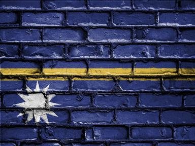
5. The flag of Nauru is blue with a thin horizontal gold stripe through the middle. There is also a 12-pointed white star just below the stripe and slightly to the left. What do the 12 points of the star represent? Hint


Question 6 of 10
6. The primary industry of Nauru for many years was the mining of phosphate deposits (from bird guano). These deposits have been nearly completely depleted, and a large percentage of the island's land area was devastated in the process. Approximately what percentage? Hint


Question 7 of 10
7. Nauru's central plateau, holds the location of the island's highest point of elevation at 65 metres. What is the name of this point that was also the site of a Japanese military outpost during World War II? Hint


Question 8 of 10
8. Nauruans celebrate Angam Day (Day of Fulfillment) on October 26th. This is in celebration of the date in 1932 that the population regained what level (following a devastating influenza epidemic in 1920)? Hint


Question 9 of 10
9. From 1888 until 1968, Nauru was under the administrative control of other nations, including the German Empire (1888-1914), Great Britain (1914-1920), Japan (1942-1945), and the combined trusteeship of the United Kingdom, Australia and New Zealand (1920-1942, 1945-1968). With which of these nations does Nauru share a currency (officially adopted in May, 2013)? Hint


Question 10 of 10
10. In its heyday, Nauru had the second highest per capita income in the world, but with the end of its phosphate exports, the country fell on hard times. Thankfully, the Nauruan government developed a tourist industry to bring the standard of living back up to (UN) acceptable levels.


(Optional) Create a Free FunTrivia ID to save the points you are about to earn:

arrow Select a User ID:
arrow Choose a Password:
arrow Your Email:


Quiz Answer Key and Fun Facts
1. The Republic of Nauru is located in the Pacific Ocean within which island group?

Answer: Micronesia

Micronesia is a region within Oceania, and is made up of thousands of islands. Apart from the Republic of Nauru, there are four other sovereign countries in the region: the Federated State of Micronesia, the Republic of Kiribati, the Republic of the Marshall Islands, and the Republic of Palau.

There are also two United States territories in Micronesia: Guam and the Commonwealth of the Northern Mariana Islands.
2. Nauru's nearest neighbour is Banaba Island, which is 300 kilometres to the east. To which island nation does Banaba Island belong?

Answer: Kiribati

Nauru is located at 0°32′ South and 166°56′ East. That means that it is only 42 kilometres south of the Equator. As determined in the question, the closest Kiribati island is 300 kilometres away to the east. The nearest of the Marshall Islands is 974 kilometres away to the northeast, the Federated States of Micronesia is 1,271 kilometres northwest, and it is 3,701 kilometres east to Palau.
3. Nauru is the smallest (independent) island nation in the world, and only Monaco and Vatican City are smaller independent countries. How small is it?

Answer: 21 square kilometres

Despite its incredibly small size, the island country is still divided into 14 administrative districts. At one point there were 169 separate villages on the island, but the island's phosphate mining operations left much of the island uninhabitable. The population is spread out along the coastal strip, essentially making one continuous settlement around the edge of the whole island.

Nauru also qualifies as the smallest republic in the world.
4. What is the main district of Nauru, containing both the Parliament House and the Nauru International Airport?

Answer: Yaren

Nauru has no official capital city. In fact, Nauru has no official cities at all. The Yaren district, by virtue of the fact that the Parliament House is there, has come to be recognized by the United Nations as the 'official district' of Nauru.
5. The flag of Nauru is blue with a thin horizontal gold stripe through the middle. There is also a 12-pointed white star just below the stripe and slightly to the left. What do the 12 points of the star represent?

Answer: The 12 indigenous tribes of the island

The Nauruan flag was adopted on the date of Nauru's independence (from UN trusteeship) on January 31, 1968. The flag's design is very representative of Nauru's geographical location, as well as having a little more symbolism. The golden stripe represents the equator, while the blue field is the Pacific Ocean. The white star represents Nauru's position in relation to the equator, as well as the significance associated with the 12 points and the indigenous tribes. It is white to represent the importance of the economy based on phosphate mining.
6. The primary industry of Nauru for many years was the mining of phosphate deposits (from bird guano). These deposits have been nearly completely depleted, and a large percentage of the island's land area was devastated in the process. Approximately what percentage?

Answer: 80%

Phosphate extraction began on Nauru in 1906 when it was under control by the German Empire. Following World War I, phosphate mining continued under the governance of the UN trusteeship (administered by the U.K., Australia and New Zealand).

An incredible 80% of the island's surface is essentially uninhabitable, which is one of the reasons that the population of Nauru is almost exclusively in that narrow band of fertile land that rings the island along the coast.

The effects of the mining also adversely affected Nauru's exclusive fishing zone, with estimates of 40% of the marine life having been killed off due to phosphate and silt runoff.
7. Nauru's central plateau, holds the location of the island's highest point of elevation at 65 metres. What is the name of this point that was also the site of a Japanese military outpost during World War II?

Answer: Command Ridge

Whether it was named for the 'military command' that held that place, or for the commanding view that the high feature offered is unclear, but the point certainly bears historical significance. There are still remnants of the Japanese military presence to be found there, including some rusted cannons and a communications bunker.
8. Nauruans celebrate Angam Day (Day of Fulfillment) on October 26th. This is in celebration of the date in 1932 that the population regained what level (following a devastating influenza epidemic in 1920)?

Answer: 1,500 people

The population of Nauru has never been extremely high, and as recently as July, 2011, the population was less than 10,000. After that epidemic in 1920 it took twelve years for the population to build back up to 1,500 people. The 1,500th person was a girl named Eidegenegen Eidagaruwo.

During World War II the population again dipped below 1,500, and as long as it remained so, Angam Day was not celebrated. After the Japanese withdrawal, it was not until March 31st of 1949 that 1,500 was reached again with the birth of Bethel Enproe Adam. Since then, Angam Day has again been celebrated (on the original October 26th).
9. From 1888 until 1968, Nauru was under the administrative control of other nations, including the German Empire (1888-1914), Great Britain (1914-1920), Japan (1942-1945), and the combined trusteeship of the United Kingdom, Australia and New Zealand (1920-1942, 1945-1968). With which of these nations does Nauru share a currency (officially adopted in May, 2013)?

Answer: Australia

Nauru has used Australian currency since Australian troops took the island from the Germans in 1914 (even though the British took administrative control at that point until 1920). That said, the Australian Dollar was only officially adopted by the Republic of Nauru on May 25th of 2013.
10. In its heyday, Nauru had the second highest per capita income in the world, but with the end of its phosphate exports, the country fell on hard times. Thankfully, the Nauruan government developed a tourist industry to bring the standard of living back up to (UN) acceptable levels.

Answer: False

Without a viable economy since the end of (any significant) phosphate mining on the island of Nauru, unemployment on the island topped 90%, and the country has relied on relief monies from other countries, as well as seeking other means to bring money in. For a time, Nauru housed refugees that were seeking asylum in Australia, for which Australia paid them. I can't say what the solution for Nauru's economic woes are, but suffice it to say, Nauru can no longer live up to its former 'Pleasant Island' moniker.
Source: Author reedy

This quiz was reviewed by FunTrivia editor Tizzabelle before going online.
Any errors found in FunTrivia content are routinely corrected through our feedback system.
11/21/2024, Copyright 2024 FunTrivia, Inc. - Report an Error / Contact Us