FREE! Click here to Join FunTrivia. Thousands of games, quizzes, and lots more!
Quiz about Plates of the World Unite

Plates of the World, Unite Trivia Quiz
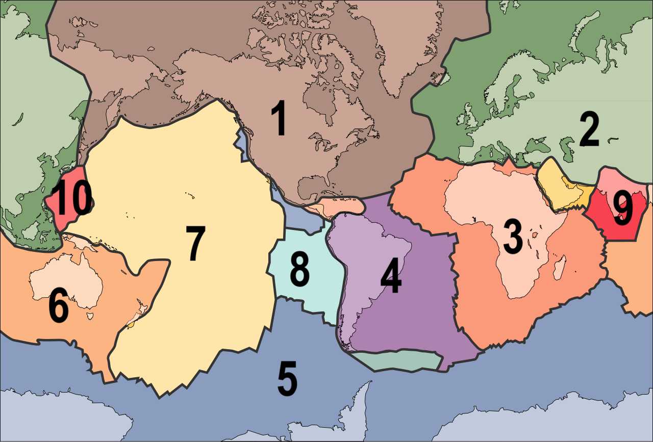
Tectonic Plates

Can you identify ten of the major tectonic plates whose movement around the Earth's surface is what has determined what that surface looks like?

A label quiz by looney_tunes. Estimated time: 3 mins.
  1. Home
  2. »
  3. Quizzes
  4. »
  5. Science Trivia
  6. »
  7. Earth Science

Author
looney_tunes
Time
3 mins
Type
Label Quiz
Quiz #
417,601
Updated
Sep 22 24
# Qns
10
Difficulty
Very Easy
Avg Score
9 / 10
Plays
247
Awards
Editor's Choice
Last 3 plays: Zirconium_ (10/10), bermalt (10/10), rahonavis (10/10).
Nazca Eurasian African North American Indian Philippine Australian Pacific South American Antarctic
* Drag / drop or click on the choices above to move them to the answer list.
1.   
2.   
3.   
4.   
5.   
6.   
7.   
8.   
9.   
10.   

Most Recent Scores
Oct 15 2024 : Zirconium_: 10/10
Oct 14 2024 : bermalt: 10/10
Oct 12 2024 : rahonavis: 10/10
Oct 12 2024 : camhammer: 10/10
Oct 12 2024 : zorba_scank: 5/10
Oct 11 2024 : Edzell_Blue: 8/10
Oct 10 2024 : golfnut66: 10/10
Oct 09 2024 : SgtHorse: 10/10
Oct 08 2024 : timka205: 8/10

Quiz Answer Key and Fun Facts
1. North American

The theory of plate tectonics was initially described as continental drift, because the largest plates are the ones which carry continents, and they are accordingly labelled by the name of the continent central to each of them. The smaller plates have names that similarly indicate where they are located, but in some cases you need specialist knowledge to work out the reference.

The idea that the continents are not fixed in place, but have been slowly moving around the surface of the planet was first seriously proposed in the early years of the 20th century, but since no mechanism to account for it could be found, much of the scientific world remained sceptical. It was not until geologists verified the phenomenon of sea floor spreading (meaning that magma was pushing up through the crust, causing the portion of the crust in that vicinity to move) in the 1960s that serious investigation into the mechanism behind the movement of plates, and the consequences this movement, began to be seriously studied.

I won't describe the extent of each plate - you can see them in the image. The North American plate is the second largest of the current plates, and is moving generally to the southwest, away from the Mid-Atlantic Ridge, at a rate of 2-3 cm a year. This brings it into conflict with the Pacific Plate, which is moving northwest at about three times the speed.
2. Eurasian

The Eurasian Plate carries all of Europe and the northern and eastern portions of continental Asia, so appears on both sides of the diagram. This commonality is one of the reasons that many geographers consider Europe and Asia to be a single continent; those who base the division on other geographical considerations, including culture, continue to consider them as separate.

The western edge of this plate lies on the Mid-Atlantic Ridge, the area in the middle of the Atlantic Ocean where evidence of magma coming up from the earth's inner layers to form mountains (well under sea level) on the surface first provided a way to explain the mechanism of continental drift. As this material comes to the surface, it pushes the plates around it to the side, leading to their movement across the planet's surface. This is an example of a divergent plate boundary, meaning the plates are moving away from each other. The volcanic activity of Iceland is due to its location where the North American and Eurasian plates are diverging.

In breaking news, a group of geologists proposed in 2024 that the Eurasian and North American plates have not yet fully separated, so should be considered as a single plate. That suggestion is not widely accepted (as yet), and was made after the diagram for this quiz was prepared.
3. African

Some geologists consider that the African Plate shown here should be considered as two, with a separate Somali Plate located on the southeastern side of the Nubian Plate. The African Plate is being divided to form two smaller plates that are moving apart along the East African Rift, location of the African Great Lakes which formed in the rift valley. The Somali Plate is moving generally to the southeast, and the Nubian Plate to the northeast.

Like the Eurasian Plate, the African Plate extends westward to the Mid-Atlantic Ridge. For many people. the way that the western side of this continent and the eastern coast of South America appear to match is one of the most obvious signs that something seems to be happening. Of course, the geologic history of the earth is not that simple - the plates did a lot of twisting as well as translating when the early supercontinent Pangaea broke up.
4. South American

As the South American Plate is moving to the west, it looks to the untrained eye as if it can just keep moving, with ocean spreading ahead of it. However, the crust under the ocean is also composed of plates, which are identified indirectly by observing the geologic activities, and directly by taking rock samples. Over time, the South American Plate has been steadily colliding with the plates on its west, primarily forming a convergent boundary with the Nazca Plate.

Since continental rocks are generally lighter than oceanic rocks, the plates on the west tend to move under the South American Plate, a process called subduction. This has resulted in the rocks on the western side of the South American Plate being pushed upwards, forming the Andes Mountains which run the length of the continent. The upthrust also weakens the continental crust, creating spots where magma can break through - volcanoes.
5. Antarctic

The Antarctic Plate lies under the continent of Antarctica, as well as extending under the nearby oceans. Its boundaries are almost completely mid-ocean ridges, which have been moving the plate steadily to the south since the breakup of Gondwanaland, the southern part of Pangaea that included what is now Antarctica, Australia, South America, Africa, Arabia and the Indian subcontinent. Its boundary with the Scotia Plate (shown in green near the middle of the diagram) is an example of a transverse boundary. That means the two plates are moving sideways past each other, rather than towards each other (convergent) or away from each other (divergent).

The Antarctic Plate is currently moving towards the Atlantic Ocean. As it runs into the South American Plate, subduction along the convergent boundary has led to uplift of the southern part of that plate, in the region of Patagonia.
6. Australian

Some consider the Australian and Indian plates to be a single plate, because the boundary in the middle of the Indian Ocean is no longer divergent, meaning they can be considered a single plate. However, as the eastern and western ends of this plate move north, the Indian end is moving more slowly than the Australian end, due to the presence of the Himalayas (to be discussed when we get to the Indian plate), which is leading to the two plates breaking apart again by this new mechanism. And then there is another part, on the southern part of the western end, which also seems to be breaking off. So in a few million years, the one or two current plates may be two or three.

For this quiz, Australia and India are being considered separate. The Australian Plate includes not only that continental mass, but also an extensive undersea area called Zealandia (named for New Zealand, which is located on its southeastern tip) which is made of rock typically found in continents, not oceanic rock. This has led to it being called a sunken continent, which runs under the Pacific Ocean from New Zealand to New Caledonia.

As the Australian Plate collides with the Pacific Plate, the heavier oceanic rock is subducted beneath the lighter continental rock. The subduction process forms an oceanic trench, the Kermadec Trench, along with the Kermadec and Tonga island groups.
7. Pacific

The Pacific Plate is the largest of the current tectonic plates on the surface of our planet. Its many boundaries with continental plates have led to the phrase Pacific Ring of Fire - those boundaries are the site of many earthquakes and volcanic activity cause by plate movement. It also has an internal hot spot (weakness that allows magma to escape) which has produced the Hawaiian Islands.

The Pacific Plate has a number of different types of boundary with the numerous plates that surround it. On the northeast and southeast are divergent boundaries with several different plates. Between them there is a transverse boundary which is responsible for the San Andreas Fault on the west coast of the United States. On the west, where it meets the Philippine Sea Plate, it is subducted to create the Mariana Trench (near the Mariana Islands), the deepest point on the Earth's crust.
8. Nazca

The Nazca Plate lies between the Pacific Plate and the South American Plate, extending along most of the continental coast (with the Antarctic Plate to its south). It is named for the Nazca region of Peru. Where the Nazca Plate meets the South American Plate, along the Peru-Chile Trench, it is subducted, a process which is the primary cause of the development of the Andes Mountains. It is also the reason why Chile has experienced some of the most violent earthquakes ever recorded.

The Nazca Plate is one of the newest plates to form, created along with the Juan de Fuca Plate and the Cocos Plate a mere 23 million years ago, when the Fallon Plate broke up. It is also one of the most swiftly-moving, travelling to the east at about 3.7 cm a year.
9. Indian

The Indian Plate is relatively small, consisting primarily of the Indian subcontinent, but also underlying some parts of southern China. When Gondwanaland broke up, this plate separated from Madagascar and initially formed a land mass that is referred to as Insular India. This island (with Sri Lanka attached) has since been moving steadily northwards, forming a convergent boundary with the Eurasian Plate that has produced the Himalayas, the highest mountain range on Earth, along with the Tibetan Plateau. The collision is still underway: the Indian Plate is moving northeast at about 5 cm a year, while the Eurasian Plate's northwards movement is only 2 cm a year.

Details of the movement of the Indian Plate are the source of a great deal of debate. Various models have been proposed to account for apparently anomalous speed and directions as indicated by rock evidence, but some of these are in contradiction with the mechanisms proposed to explain plate movements in other areas. While nobody doubts that plates do move, and our understanding of the mechanism of their movement has increased dramatically in the less-than-a-century since scientists began to explore it seriously, there is still much to be sorted out!
10. Philippine

The Philippine Plate (more properly, the Philippine Sea Plate) is sometimes considered to be part of the Australian plate, but it is barely connected, at best, and most deal with it as an independent plate. As an oceanic plate, its shape is defined by its many boundaries with nearby smaller plates. Most of these boundaries are convergent, and marked by trenches. The Philippine Plate, the Amurian Plate and the Okhotsk Plate meet near Mount Fuji in Japan.

The Philippine Plate has a divergent boundary with the small Mariana Plate, on which the Mariana Islands are located. The Philippine Mobile Belt, the complicated boundary between the Philippine Plate and the Eurasian Plate, is the location of the Philippine Islands. It is sometimes considered a separate microplate.
Source: Author looney_tunes

This quiz was reviewed by FunTrivia editor rossian before going online.
Any errors found in FunTrivia content are routinely corrected through our feedback system.
10/16/2024, Copyright 2024 FunTrivia, Inc. - Report an Error / Contact Us