FREE! Click here to Join FunTrivia. Thousands of games, quizzes, and lots more!
Quiz about A Peek at the Philippines

A Peek at the Philippines Trivia Quiz


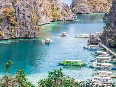
This quiz takes a quick look at the geography of the Philippines, a nation of islands. But first, a history question:

A multiple-choice quiz by suomy. Estimated time: 4 mins.
  1. Home
  2. »
  3. Quizzes
  4. »
  5. Geography Trivia
  6. »
  7. Asia
  8. »
  9. Philippines

Author
suomy
Time
4 mins
Type
Multiple Choice
Quiz #
378,527
Updated
Dec 03 21
# Qns
10
Difficulty
Average
Avg Score
7 / 10
Plays
1186
Awards
Top 35% Quiz
Last 3 plays: chuckdaniel (9/10), Guest 175 (3/10), lones78 (10/10).
- -
Question 1 of 10
1. The modern name for the country can trace its roots to the explorer Ruy López de Villalobos. Who was he honouring when naming the country in 1543? Hint


Question 2 of 10
2. Following which directions would lead you to the Philippines? Hint


Question 3 of 10
3. The Philippines is part of the Pacific Ring of Fire. Which of the following features are typical of this belt? Hint


Question 4 of 10
4. The Rice Terraces of the mountainous Cordilleras are the only form of stone construction in the Philippines uninfluenced by colonial cultures. What crop was grown before rice took over around 1600 AD? Hint


Question 5 of 10
5. Which term most accurately describes the native forests? Hint


Question 6 of 10
6. Ninety kilometres north-west of the capital Manila can be found Lake Pinatubo, possibly the country's deepest lake at 600 metres depth. How was it formed? Hint


Question 7 of 10
7. Turning to energy, which renewable resource contributes the most to the Philippine power network? Hint


Question 8 of 10
8. The Chocolate Hills of Bohol are a collection of more than 1,250 cone-shaped limestone hills spread over some 50 square kilometres. Why 'chocolate'? Hint


Question 9 of 10
9. Lending its name to a 'Star Trek' character, in which Philippine sea can you find Tubbataha Reefs National Park? Hint


Question 10 of 10
10. Going underground now, this Philippine tourist attraction on the island of Palawan was until 2007 considered the longest underground river in the world. Featuring stalactites, stalagmites and large chambers up to 2.5 million cubic metres in size, what type of rock does the river pass through? Hint


(Optional) Create a Free FunTrivia ID to save the points you are about to earn:

arrow Select a User ID:
arrow Choose a Password:
arrow Your Email:


Most Recent Scores
Today : chuckdaniel: 9/10
Jan 18 2025 : Guest 175: 3/10
Jan 13 2025 : lones78: 10/10
Jan 12 2025 : portalrules123: 10/10
Jan 12 2025 : Guest 131: 5/10
Jan 07 2025 : jay2710: 5/10
Dec 16 2024 : Guest 103: 7/10
Dec 12 2024 : lizenarih: 7/10
Dec 03 2024 : Guest 136: 3/10

Score Distribution

quiz
Quiz Answer Key and Fun Facts
1. The modern name for the country can trace its roots to the explorer Ruy López de Villalobos. Who was he honouring when naming the country in 1543?

Answer: Philip II of Spain

Consisting of some 7,107 islands, a number of different names have been given to various islands in the archipelago. It is, however, the name chosen by Spanish explorer Villalobos which has come through to the modern day.

Philip II of Spain was also known as Philip I of Portugal. Philip II of Portugal was Philip III of Spain (and Philip VI of Burgundy). Philip II of Macedon was the father of Alexander the Great. The French Philip was a powerful king during the latter half of the 12th century and into the 13th century.
2. Following which directions would lead you to the Philippines?

Answer: South from Taiwan

The main islands of the Philippines are directly south of Taiwan across the Luzon Strait. Although the strait is some 250 km wide, there are a number of Philippine islands within the Strait and so arguably it is the Bashi Channel which separates the two countries.

One theory is that the earliest Philippine settlers were Austronesians out of Taiwan, who themselves originally came from the Yangtze river area of China.
3. The Philippines is part of the Pacific Ring of Fire. Which of the following features are typical of this belt?

Answer: Earthquakes

Also known as the circum-Pacific belt, volcanic activity features strongly and this means lots of earthquakes. Some 75% of the world's active volcanoes and around 90% of the world's earthquakes are said to occur in the Pacific Ring of Fire, which extends from New Zealand up the east coast of Asia, across the Aleutian trench and down the west coast of the Americas.

Tornadoes, monsoons and tropical temperatures also occur in the Philippines, however, these are not connected to plate tectonics.
4. The Rice Terraces of the mountainous Cordilleras are the only form of stone construction in the Philippines uninfluenced by colonial cultures. What crop was grown before rice took over around 1600 AD?

Answer: Taro

Traditionally, Filipinos used wood rather than stone in buildings. The terraces were an exception. Perhaps a thousand years old, they were built of stone. Because of the mountainous terrain, the Cordillera tribes were able to prevent domination by foreign invaders and thus to preserve their own culture.

The Terraces were put on the UNESCO World Heritage List in 1995. The 2,000-year-old Banaue Rice Terraces in the Ifugao province are also a regular tourist fixture, but did not make it onto the UNESCO list due to contamination by modern structures.

Potatoes came from South America originally, maize from Mexico and wheat from the Middle East. Taro is believed to have come from India and South-east Asia.
5. Which term most accurately describes the native forests?

Answer: Tropical rainforest

The Philippines lies close to the equator and has a tropical maritime climate with some humid subtropical islands. Being in the typhoon belt, torrential rain is a regular feature.
6. Ninety kilometres north-west of the capital Manila can be found Lake Pinatubo, possibly the country's deepest lake at 600 metres depth. How was it formed?

Answer: Volcanic eruption

The lake was only formed in 1991 when Mount Pinatubo blew its top. The volcano's summit was replaced by a caldera measuring 2.5 kilometres in diameter. Copious rainfall has seen the crater fill rapidly.

Concerns about the potential collapse of the caldera under the weight of water led to a quarter of the volume being drained. Erosion may result in the collapse of the lake walls and drainage of the lake before too long.
7. Turning to energy, which renewable resource contributes the most to the Philippine power network?

Answer: Hydro

Coal-fired power stations topped the list in 2014 at over 30% for installed capacity, followed by hydro-electric then oil-based generation at around 19% each. Natural gas power stations came next then geothermal at around 10% of total installed capacity, according to the Philippine Department of Energy. Wind, biomass and then solar bring up the rear.

Construction on a nuclear power plant at Morong, Bataan started in 1976 in response to the 1973 oil crisis. The Three Mile Island accident in 1979 resulted in a temporary halt to construction and some 4,000 faults being unearthed. The 1986 Chernobyl meltdown saw the nearly-complete Bataan project halted. It took another 30 years to pay off the debt associated with it. Never operational, in 2011 it was planned to turn it into a tourist attraction.
8. The Chocolate Hills of Bohol are a collection of more than 1,250 cone-shaped limestone hills spread over some 50 square kilometres. Why 'chocolate'?

Answer: The mounds turn brown during the dry season

The mounds are grass-covered and brown off towards the end of the dry season. The Philippines is not known for cocoa bean production and any cash crops (such as rice) tend to be grown between the mounds, which are typically between 30 and 50 metres high, rather than on top of them.

A big threat to this tourist attraction is commercial quarrying which tends to flatten the hills. Despite legislative protection, mining and development pressure continues.
9. Lending its name to a 'Star Trek' character, in which Philippine sea can you find Tubbataha Reefs National Park?

Answer: Sulu Sea

Declared by UNESCO as a World Heritage Site in 1993, it sits in the middle of the Sulu Sea within the Philippine archipelago. This marine and bird sanctuary is focussed on two uninhabited atolls and a reef. It boasts a very high concentration of marine species with, for example, some 600 fish species, 360 coral species and 100 bird species represented.

Its remote position and lack of drinking water have helped protect it, however, it is now under pressure from over-fishing and destructive fishing practices (such as dynamite fishing and the use of cyanide).

Gene Roddenberry, the screenwriter for the original 'Star Trek' series, is said to have chosen the character name 'Sulu' to represent Asia. The other characters were from 'Star Trek: The Next Generation' (William Riker), 'Babylon 5' (Delenn) and 'Star Trek: Deep Space Nine' (Benjamin Sisko).
10. Going underground now, this Philippine tourist attraction on the island of Palawan was until 2007 considered the longest underground river in the world. Featuring stalactites, stalagmites and large chambers up to 2.5 million cubic metres in size, what type of rock does the river pass through?

Answer: Limestone

A 24-kilometre cave runs from Mount Saint Paul to the South China Sea and includes the last 8.2-kilometre section of the Cabayugan River (also known as the Puerto Princesa Subterranean River). The bottom half of the river is navigable and tidal. It was declared a World Heritage Site by UNESCO in 1999 and is part of the Puerto Princesa Subterranean River National Park, home to at least 800 plant species, 165 bird species and 30 mammal species.

The longest underground river, which is also accessible from the surface, found to date (2015) is to be found in the Yucatan Peninsula of Mexico. It twists and turns for 153 kilometres, or about 10 kilometres as the crow flies.
Source: Author suomy

This quiz was reviewed by FunTrivia editor Tizzabelle before going online.
Any errors found in FunTrivia content are routinely corrected through our feedback system.
1/20/2025, Copyright 2025 FunTrivia, Inc. - Report an Error / Contact Us