FREE! Click here to Join FunTrivia. Thousands of games, quizzes, and lots more!
Quiz about A Photo Journey to the EBC

A Photo Journey to the EBC Trivia Quiz


Things on my bucket list: drive a Lamborghini - check! Go Scuba diving on Roatan - check! Climb Mt. Everest... well, here's how I did it. See what you know of this magical and challenging journey I took to Everest Base Camp (Nepal).

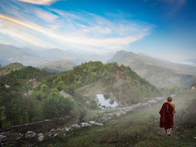
A photo quiz by LeoDaVinci. Estimated time: 4 mins.
  1. Home
  2. »
  3. Quizzes
  4. »
  5. Geography Trivia
  6. »
  7. Asia
  8. »
  9. Nepal

Author
LeoDaVinci
Time
4 mins
Type
Photo Quiz
Quiz #
368,089
Updated
Aug 10 23
# Qns
10
Difficulty
Average
Avg Score
7 / 10
Plays
391
Awards
Editor's Choice
Last 3 plays: Guest 81 (3/10), Dreessen (8/10), 1nn1 (10/10).
-
Question 1 of 10
1. The trek to the Everest Base Camp (EBC) starts with a flight to one of the most dangerous airports in the world. Landing or taking off from Tenzing-Hillary Airport is a harrowing experience. What town is the airport located in? Hint


Question 2 of 10
2. The journey to the EBC largely follows along the bank of an ice-cold river. Its name sounds a bit like it might be from a cowboy movie. What is the name of one of the highest rivers, in terms of elevation of point of origin, in the world? Hint


photo quiz
Question 3 of 10
3. The trip to the EBC stops in the largest town in Sagarmāthā National Park. It's an opportunity to rest, acclimatize, and purchase things, as the town is largely one giant market. What's the name of the town? Hint


Question 4 of 10
4. The next leg of the journey took us to Tengboche, a village that houses the largest monastery in the region. What religion is the monastery, as well as the large majority of the people in that region? Hint


photo quiz
Question 5 of 10
5. From Tengboche one has an amazing view of one of the most beautiful mountains in the entire Himalayan Range, maybe even in the world. What is this "mother's pearls" mountain called? Hint


Question 6 of 10
6. While most treks to the EBC choose to spend the night at Dingboche, there is another option. The village of Pheriche is a quiet alternative to Dingboche, and you get better views of sunsets. What direction is Pheriche in relation to Dingboche? Hint


photo quiz
Question 7 of 10
7. Continuing north to the EBC, to pass through the Dughla Pass is a must. There is a sheltered valley in the pass with hundreds of stupas. Who are these stupas dedicated to? Hint


Question 8 of 10
8. After the Dughla Pass, and all the way up to EBC, the land is harsh and inhospitable. You're on Khumbu! What is Khumbu? Hint


photo quiz
Question 9 of 10
9. The last stop for the night on the journey is at Gorakshep, a tiny village. One of the more interesting legs of the trek is a climb to see the sunrise over Everest on a black rocky 'hill' whose height reaches approximately 5,600 m. What is this place called?
Hint - in the answers there are three passes and one hill name...
Hint


Question 10 of 10
10. Finally, you climb to the Everest Base Camp! Is this the actual base camp for mountaineers seeking to summit Mt. Everest?


photo quiz

(Optional) Create a Free FunTrivia ID to save the points you are about to earn:

arrow Select a User ID:
arrow Choose a Password:
arrow Your Email:


View Image Attributions for This Quiz

Most Recent Scores
Dec 20 2024 : Guest 81: 3/10
Nov 25 2024 : Dreessen: 8/10
Nov 16 2024 : 1nn1: 10/10

Quiz Answer Key and Fun Facts
1. The trek to the Everest Base Camp (EBC) starts with a flight to one of the most dangerous airports in the world. Landing or taking off from Tenzing-Hillary Airport is a harrowing experience. What town is the airport located in?

Answer: Lukla

The trip to the EBC starts in Lukla, a small town in northern Nepal with an airport... well... if it might even be called that. The landing strip of Tenzing-Hillary Airport is short and heavily inclined. On the north end of the strip is a rock wall. The south end of the strip is a sheer drop. Planes, small planes, small planes with a strict weight restriction, must land expertly and gingerly and brake hard while heading uphill, taxiing directly into the parking area to increase their roadway. Planes taking off brake hard and then take off... sometimes even dropping off the south end of the cliff to gain airspeed before heading to their destination. Kathmandu, usually.

At least your trip to the EBC will start off with an adventure!
2. The journey to the EBC largely follows along the bank of an ice-cold river. Its name sounds a bit like it might be from a cowboy movie. What is the name of one of the highest rivers, in terms of elevation of point of origin, in the world?

Answer: Dudh Koshi

Dudh Koshi is the river resulting from melting glaciers that are found in between the majestic peaks of the Himalayas. It is ice-cold as a result, all year round, and, the water is not potable. This is mostly due to the abundance of yak who urinate in the river causing it to have an unusually high amount of E. coli.

Dudh Koshi is a rapidly flowing river, resulting in some of the highest (and most dangerous) rapids in the world. The water is white, hence the name "mother's milk". Walking along it, you cross several really high bridges over and back across several times. At times, you're sharing the path with animals and people carrying goods on their backs.
3. The trip to the EBC stops in the largest town in Sagarmāthā National Park. It's an opportunity to rest, acclimatize, and purchase things, as the town is largely one giant market. What's the name of the town?

Answer: Namche Bazaar

Namche Bazaar is the largest town in the Khumbu area in the Sagarmāthā National Park. It is the first place where people might feel altitude sickness and most people stay an extra night in Namche in order to allow their bodies to begin the acclimatization process. It is a bustling trading center for many of the people on the trek to EBC, and prices are accordingly adjusted. There are many amenities in the town: a post office, Internet cafes, bakeries, even a police outpost. Be prepared, the entire town is built on hills so you're going to be climbing a lot of stairs. Additionally, you'll be sharing those stairs with dzo carrying goods.

(A dzo is a yak-cow hybrid)

In the picture is the southern entrance to the town.
4. The next leg of the journey took us to Tengboche, a village that houses the largest monastery in the region. What religion is the monastery, as well as the large majority of the people in that region?

Answer: Buddhist

The Tengboche monastery is an old Buddhist monastery. The altitude of the monastery is 3870m, so, people usually start feeling the lack of oxygen around this point. The monks in the monastery call for prayer twice a day and all are welcome to attend. The services are very calming and musical, and the art inside the monastery is breathtaking (though photography is forbidden inside the building). One of the interesting fact I learned is that the drums that the monks play on are covered in skin... from monks who have passed.

Tengboche is the first place on the trek where you can get a really good view of Mt. Everest.

In the picture is the entrance to the monastery.
5. From Tengboche one has an amazing view of one of the most beautiful mountains in the entire Himalayan Range, maybe even in the world. What is this "mother's pearls" mountain called?

Answer: Ama Dablam

Ama Dablam is a peak near Tengboche that reaches up to 6812 m. It is a very beautiful mountain, and its name means "mother's pearl necklace". In 2020 it was the third-most climbed mountain in the region. While not nearly as high as Mt. Everest, it has very steep cliffs and a very temperamental glacier, so, accidents have happened on the mountain. Nevertheless, it is considered a very photogenic mountain, so much so that there is a Gmail background that has a picture of Ama Dablam.

The first successful ascent of Ama Dablam's main summit was achieved by a New Zealand team in 1961. Since then, it has become a sought-after climbing destination for those looking for a challenging and visually rewarding mountaineering experience.
6. While most treks to the EBC choose to spend the night at Dingboche, there is another option. The village of Pheriche is a quiet alternative to Dingboche, and you get better views of sunsets. What direction is Pheriche in relation to Dingboche?

Answer: West

Dingboche and Pheriche are two villages that are relatively close to one another. Both are popular spots for EBC trekkers to stop for the night. In fact, both villages are at an elevation of around 4,400 m and many treks stop for two nights in order to acclimatize. While most treks go through Dingboche, Pheriche is also a very nice alternative, especially during the high season for trekking (when beds are at a premium).

While Dingboche is to the east and gets more daylight sun and less wind, Pheriche, to the west, gets amazing sunsets and is a quiet and laid-back type of village. No matter where you stay, all paths lead back to the same routes in the end.
7. Continuing north to the EBC, to pass through the Dughla Pass is a must. There is a sheltered valley in the pass with hundreds of stupas. Who are these stupas dedicated to?

Answer: Dead climbers on Everest

When one passes through the Dughla Pass, one feels a sense of awe, wonder, and reverence for all of the stupas there. A stupa is a memorial pile of rocks, and is a traditional Buddhist and Hindu custom. The families of people who have perished on the climb to Mt. Everest's summit can put up a stupa in the Dughla Pass. As we passed through, I could only marvel at the amount of stupas decorating the pass.

It is located near the Chola Tsho, a sacred lake for the Sherpa people. It also makes for a very breathtaking vista.

Since we had seen the movie "Everest" (2015) when were staying at Namche Bazaar, we were familiar with the story of Scott Fischer and Rob Hall. We went to visit the stupas of both these great mountaineers. On both stupas there were many Buddhist prayer flags covering them in memoriam. It was a very staggering experience just being there.
8. After the Dughla Pass, and all the way up to EBC, the land is harsh and inhospitable. You're on Khumbu! What is Khumbu?

Answer: Glacier

The Khumbu Glacier is located between Mt. Everest and Lhose/Nuptse and is a permanent glacier. As such, it is the world's highest glacier in terms of elevation as it sits between 7,600 m to 4,900 m. It is the starting point of many Everest summit treks, and is a constant source of danger to mountaineers as it is always moving, even during summit season when it is traditionally colder and less active.

In the picture you see the exposed glacier. However, the deposits in the front of the picture are actually glacier as well. Run off from melting ice deposits silt and soil atop the glacier giving it a look as though it is land, however, we were actually walking on a river of ice.
9. The last stop for the night on the journey is at Gorakshep, a tiny village. One of the more interesting legs of the trek is a climb to see the sunrise over Everest on a black rocky 'hill' whose height reaches approximately 5,600 m. What is this place called? Hint - in the answers there are three passes and one hill name...

Answer: Kala Patthar

Kala Patthar, literally 'black hill' in Lhasa, is a hill overlooking EBC where you get amazing views. While the locals call the height anywhere from 5545m and 5555m, it was actually measured by satellite to be 5643m above sea level. A pretty darned tall 'hill'! Atop Kala Patthar you can see all around panoramically with amazing views of the peaks, and the closest you will see Mt. Everest on the EBC trek (you can't see the peak from EBC itself).

Oh Kala Patthar... surely the toughest part of the entire trek. It's really not a difficult hill to climb, physically. However, due to the thin air and the cold, it felt like my legs were lead weights and every step was a chore. I had to put down my head and go left, right, left, right, until... I made it! The sunrise was breathtaking and the views left me speechless!

In the picture, sunrise is between Mt. Everest on the left and Nuptse on the right. Don't let the parallax fool you; Nuptse seems taller because it's closer. In the foreground is the black rock of Kala Patthar.
10. Finally, you climb to the Everest Base Camp! Is this the actual base camp for mountaineers seeking to summit Mt. Everest?

Answer: No

The Everest Base Camp that trekkers get to walk up to is the old Everest Base Camp and is a few kilometers south of where the new EBC is. You don't generally want to walk to the new EBC if you don't have to. It is a messy and littered place, and due to the cold weather and the ice it sits on, it retains bacteria and viruses so you have a higher chance of getting sick if you stay there. However, getting to EBC was an awesome experience. I stood where great people had stood before me and set out to conquer the tallest peak on Earth! It was a very humbling moment.

In the picture is the new EBC taken from the old EBC. It was not summit season for Everest so there was only one camp at that time. That expedition was going to climb Nuptse and we all wished them success in our hearts.
Source: Author LeoDaVinci

This quiz was reviewed by FunTrivia editor agony before going online.
Any errors found in FunTrivia content are routinely corrected through our feedback system.
Related Quizzes
This quiz is part of series Leo's Around The World List:

Quizzes I have authored that take you around the world.

  1. Bolivia - In Unity and in Strength Easier
  2. Tonga - An Island Monarchy Average
  3. Gab-On the Equator Average
  4. A Photo Journey to the EBC Average
  5. Bustling and Beautiful Bulgaria Average
  6. Bhutan - Small Country, Big Dragons Average
  7. Walk Like an Egyptian Average
  8. Enclave and... Exclave Average
  9. Nice Little Nauru Average
  10. Lots of 'L' Cities Easier
  11. Don't Pass on Iraq Average
  12. Geoglyphs! Average

12/21/2024, Copyright 2024 FunTrivia, Inc. - Report an Error / Contact Us