FREE! Click here to Join FunTrivia. Thousands of games, quizzes, and lots more!
Quiz about Belize It Or Not

Belize It Or Not Trivia Quiz


The small Central American nation on the Caribbean coast is a country full of unbelievable sights.

A multiple-choice quiz by Snowman. Estimated time: 5 mins.
  1. Home
  2. »
  3. Quizzes
  4. »
  5. Geography Trivia
  6. »
  7. Central America
  8. »
  9. Belize

Author
Snowman
Time
5 mins
Type
Multiple Choice
Quiz #
315,553
Updated
Dec 03 21
# Qns
10
Difficulty
Average
Avg Score
7 / 10
Plays
4957
Awards
Top 5% quiz!
Last 3 plays: Guest 100 (8/10), ChrisC7 (9/10), Guest 160 (9/10).
- -
Question 1 of 10
1. Belize was adopted as the country's name in 1973. Prior to this it was known by what name, reflective of the nation of which it was a colony? Hint


Question 2 of 10
2. As well as a change of name, Belize has undergone a change of capital. The nation's largest city, Belize City, was capital until 1971 when the capital was moved to the newly built city of Belmopan. What natural phenomenon had been the spur towards moving the capital? Hint


Question 3 of 10
3. Belize shares a land border with just two countries. Which two? Hint


Question 4 of 10
4. Running for 300 kilometres off the coast of Belize are a series of over 400 islands known as cayes. Each of these cayes rises from a natural structure that is the largest of its kind in the northern hemisphere and the second largest in the world. What kind of structure is this? Hint


Question 5 of 10
5. Belize is a warm country. The average temperature all twelve months of the year is over 18°C (64.4°F). By Köppen climate classifications this means that Belize has what type of climate? Hint


Question 6 of 10
6. Which of the following statements about Belize is NOT true? Hint


Question 7 of 10
7. At the turn of the 21st century, the tallest building in Belize was still a structure that was built by the civilization that dominated the area in the first millennia of the modern era. It stands in the complex of temples at Caracol in the west of Belize which can be found in the foothills of the mountains that bear that civilization's name. What are the mountains called? Hint


Question 8 of 10
8. Situated off the coast of Belize is a giant underwater sinkhole, which at 300 metres diameter is believed to be the largest of its kind in the world. Its most striking feature is its colour, which makes it stand out from the ocean surrounding it and gives it its name. What is it called? Hint


Question 9 of 10
9. For many years the small seaside town of Placencia claimed its own world record, which it lost temporarily after weather damage in 2001. What was this record? Hint


Question 10 of 10
10. Despite having self-government from 1964, movement towards full independence for Belize was very slow. The hold-up was due to a territorial claim that dated back to the 18th century. One country claimed Belize as the 23rd department of its own country and refused to acknowledge its independence until 1992, eleven years after the rest of the world. Which country is this? Hint


(Optional) Create a Free FunTrivia ID to save the points you are about to earn:

arrow Select a User ID:
arrow Choose a Password:
arrow Your Email:


Most Recent Scores
Today : Guest 100: 8/10
Dec 08 2024 : ChrisC7: 9/10
Nov 29 2024 : Guest 160: 9/10
Nov 27 2024 : Guest 184: 8/10
Nov 26 2024 : Guest 105: 4/10
Nov 19 2024 : Guest 70: 9/10
Nov 15 2024 : Guest 190: 7/10
Nov 14 2024 : Guest 174: 6/10
Nov 13 2024 : Guest 190: 7/10

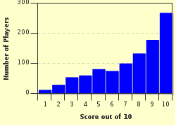
Score Distribution

quiz
Quiz Answer Key and Fun Facts
1. Belize was adopted as the country's name in 1973. Prior to this it was known by what name, reflective of the nation of which it was a colony?

Answer: British Honduras

English buccaneers began to exploit the woodlands of Belize in the early 17th century. The name Belize possibly comes from one such pirate, whose name was Peter Wallace. The Spanish called him "Ballis" and his name was supposedly given to the recently discovered Belize River.

Later that century, the British began to settle in the area and gradually began to run it politically. No formal claim on the land was made, however, until 1862 when it was declared as "British Honduras". The name persisted until 1973 by which time Britain had stepped away from the day-to-day running of the country allowing Belize to prepare for independence.
2. As well as a change of name, Belize has undergone a change of capital. The nation's largest city, Belize City, was capital until 1971 when the capital was moved to the newly built city of Belmopan. What natural phenomenon had been the spur towards moving the capital?

Answer: Hurricane

Fortunately, the arrival of Hurricane Hattie in October 1961 had been anticipated and the potentially large number of casualties was reduced by a large evacuation of Belize City and other coastal areas. The first devastating hurricane that had hit the city in 1931 came unexpectedly and cost the lives of close to 2,000 inhabitants.

The great cost of the 1961 storm, which was the last of the twentieth century to reach category five status, came in terms of the city's buildings. Barely a single building in the city escaped damage and around 40% were destroyed completely.

The level of damage led the government to petition the UK for the funds to build a new capital in the country's inland area where damage of this kind was less likely to occur.
3. Belize shares a land border with just two countries. Which two?

Answer: Guatemala and Mexico

Despite once sharing a name, Honduras and Belize are not contiguous and do not share a land border. The two countries are separated by a strip of Guatemalan land about 30 miles wide that borders Amatique Bay.
4. Running for 300 kilometres off the coast of Belize are a series of over 400 islands known as cayes. Each of these cayes rises from a natural structure that is the largest of its kind in the northern hemisphere and the second largest in the world. What kind of structure is this?

Answer: Barrier reef

The Belize barrier reef is part of the Mesoamerican reef that runs for 900km alongside the coast of the Yucatan peninsula. It is second in length to the Great Barrier Reef in Australia. The reef was made a UNESCO World Heritage Site in 1996 for its natural beauty and as a home for many endangered species.

Like any reef system it is very vulnerable to climatic events and human pollution and, although in a sparsely populated area such as Belize the effects of human action are thought to be less of an issue, the reef was nevertheless placed on UNESCO's "in danger" list in 2009 due to the excessive cutting of the mangrove forests in the area.
5. Belize is a warm country. The average temperature all twelve months of the year is over 18°C (64.4°F). By Köppen climate classifications this means that Belize has what type of climate?

Answer: Tropical

According to the Köppen climate classification system, a tropical climate is not necessarily defined by geographical location. Rather, it is the mean temperature that defines the classification of the climate. Belize, however, does fall within the tropical region between the Tropics of Capricorn and Cancer, with the north of the country at around 19°N and the south, around 15°N.

Belize has distinct dry and rainy seasons. The dry season runs from January to April in the north of the country and from February to April in the south.
6. Which of the following statements about Belize is NOT true?

Answer: Its currency is the Belize pound

The Belizean currency is the Belize dollar (BZ$) which was founded in 1885. It was the only British colony of the Caribbean area not to use sterling as its currency until 1955. The value of the dollar has been pegged to the US dollar (as BZ$2 to US$1) since 1978.
7. At the turn of the 21st century, the tallest building in Belize was still a structure that was built by the civilization that dominated the area in the first millennia of the modern era. It stands in the complex of temples at Caracol in the west of Belize which can be found in the foothills of the mountains that bear that civilization's name. What are the mountains called?

Answer: Maya mountains

The Canaa temple at Caracol was built by the Mayans around 1000AD and stands at 143 feet tall (approx 43.5 metres). Its windows were built so that they aligned with the sun on the solstice and equinox days. From the top it gives magnificent views of the Chiquibul Rainforest.
8. Situated off the coast of Belize is a giant underwater sinkhole, which at 300 metres diameter is believed to be the largest of its kind in the world. Its most striking feature is its colour, which makes it stand out from the ocean surrounding it and gives it its name. What is it called?

Answer: The Great Blue Hole

Such underwater sinkholes are known as blue holes due to the contrast between the deep blue of the water they contain and the lighter blue of the shallower waters surrounding them. Blue holes are formed from collapsed underwater limestone caves that themselves formed in times when sea levels were lower, such as past ice ages. The Great Blue Hole was, in those times, an opening to an underground network of caves that became flooded as the ice melted and sea levels rose. Though the roof of the cave opening has collapsed due to the weight of water, the caves can still be explored by divers.

Typically, blue holes have depths of around 100-125 metres with the Great Blue Hole being towards the top end of this scale. Though it is believed to be the widest blue hole in the world, it is not the deepest. That record is held by Dean's Blue Hole in the Bahamas which is just over 200 metres deep.
9. For many years the small seaside town of Placencia claimed its own world record, which it lost temporarily after weather damage in 2001. What was this record?

Answer: It had the narrowest main street in the world

Placencia is a town with a population of around 1,000 people that is situated at the end of a narrow peninsula in the south of the country. It attracts many tourists for its laid back atmosphere (to the point of horizontal - hammocks essential), its beautiful lagoon and the nearby rainforest.

Its main street is just four feet (or 1.2 metres) wide, making it, according to the "Guinness World of Records" in 2000, the narrowest main street in the world. The original street was destroyed in a hurricane in 2001 but was rebuilt to the same size a year later.
10. Despite having self-government from 1964, movement towards full independence for Belize was very slow. The hold-up was due to a territorial claim that dated back to the 18th century. One country claimed Belize as the 23rd department of its own country and refused to acknowledge its independence until 1992, eleven years after the rest of the world. Which country is this?

Answer: Guatemala

Guatemala had for a long time threatened force to back its claim to Belizean territory. The claim went back to peace treaties signed between the colonial powers of the United Kingdom and Spain in the late 18th century over sovereign powers in the wider region of Central America. When the new republics in this region gained independence from Spain in 1821 they asserted their right to inherit Spain's sovereign powers but the UK refused to accept this and maintained their rights over what was then British Honduras.

The UK accepted Belize's argument for independence in the early 1960s but was unable to come to an agreement with Guatemala over its claim on the land. In 1975, the UK abandoned attempts at negotiation and handed over the matter to the UN and other international organisations.

Over the course of the next six years, the Central American nations that had initially backed Guatemala's claim began to turn their favour towards Belize as Guatemala's actions threatened to destabilise peace in the region. By 1981, Guatemala stood alone and despite continued attempts to broker one, Belize declared independence without coming to an agreement with Guatemala.

Guatemala continued to assert its claim on Belize but in 1992, Guatemalan President Jorge Serrano recognised Belize's independence. In spite of this recognition, Guatemala continued to dispute its border with Belize into the 21st century.
Source: Author Snowman

This quiz was reviewed by FunTrivia editor Pagiedamon before going online.
Any errors found in FunTrivia content are routinely corrected through our feedback system.
Related Quizzes
This quiz is part of series Take This Title And Run With It! (1):

A miscellany of older quizzes with titles suggested in the Authors' Lounge by my old friend highfells.

  1. It's Not Irrelevant, It's a Hippopotamus! Average
  2. A Boiled Egg Is Hard To Beat Average
  3. A Momentary Lapse Of Reason Average
  4. A Quiz Called Sebastian Average
  5. And How Will You Be Paying, Sir? Average
  6. Around The World In Twenty Plays Average
  7. Belize It Or Not Average
  8. Crochet Tiger, Knit A Dragon Average

12/21/2024, Copyright 2024 FunTrivia, Inc. - Report an Error / Contact Us