FREE! Click here to Join FunTrivia. Thousands of games, quizzes, and lots more!
Quiz about Cameroon Africa in Miniature

Cameroon- Africa in Miniature Trivia Quiz


The Republic of Cameroon is sometimes called "Africa in miniature" because of its diversity. Come and explore this fascinating country.

A multiple-choice quiz by Daaanieeel. Estimated time: 4 mins.
  1. Home
  2. »
  3. Quizzes
  4. »
  5. Geography Trivia
  6. »
  7. Africa
  8. »
  9. Cameroon

Author
Daaanieeel
Time
4 mins
Type
Multiple Choice
Quiz #
345,381
Updated
Dec 03 21
# Qns
10
Difficulty
Average
Avg Score
7 / 10
Plays
1575
Awards
Top 35% Quiz
- -
Question 1 of 10
1. Cameroon is a country in the west of Central Africa. Which of the following countries does Cameroon NOT share a border with? Hint


Question 2 of 10
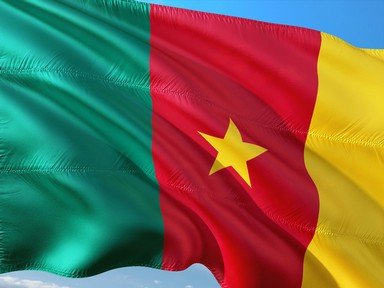
2. The flag of Cameroon features three vertical bands and a star in the middle band. What colour does not appear on the Cameroon flag? Hint


Question 3 of 10
3. On January 1, 1960 French Cameroon became independent and became the Republic of Cameroon. Which neighbouring state merged with French Cameroon on the first of October 1961? Hint


Question 4 of 10
4. Standing at approximately 4040 metres (13255 feet) to the peak, Mount Cameroon is the highest point in Cameroon. Is it an active, dormant or extinct volcano?

Answer: (One Word, Active, Dormant or Extinct)
Question 5 of 10
5. Yaoundé is the capital city of Cameroon. Which city has an international airport and is Cameroon's largest port? Hint


Question 6 of 10
6. Which form of currency is used in Cameroon? Hint


Question 7 of 10
7. Cameroon is extremely diverse in terms of terrain and climate. Which of these will you NOT find in Cameroon? Hint


Question 8 of 10
8. One of the major geographical features is the South Cameroon Plateau. It experiences two wet and two dry seasons, one long and one short of both. When does it experience its long wet season? Hint


Question 9 of 10
9. The Wouri River gave Cameroon its name after a Portuguese explorer named it "Rio dos Camarões". What does "Rio dos Camarões" mean? Hint


Question 10 of 10
10. The crater lake of Lake Nyos in the north-west region of Cameroon was called the "World's Deadliest Lake" by Guinness World Records in 2008. In 1986, it was the cause of one of the darkest times in Cameroon history after a natural disaster killed thousands. What happened? Hint


(Optional) Create a Free FunTrivia ID to save the points you are about to earn:

arrow Select a User ID:
arrow Choose a Password:
arrow Your Email:


Quiz Answer Key and Fun Facts
1. Cameroon is a country in the west of Central Africa. Which of the following countries does Cameroon NOT share a border with?

Answer: Rwanda

Cameroon is in the west of Central Africa and bordering countries include Nigeria to the west, Central African Republic to the east, Chad to the northeast and Gabon, the Republic of Congo and Equatorial Guinea to the south. It also lies on the coastline of the Bight of Bonny, which is part of the Gulf of Guinea and the Atlantic Ocean.

It is divided in to 10 regions. It is the 54th largest country by area in the world.
2. The flag of Cameroon features three vertical bands and a star in the middle band. What colour does not appear on the Cameroon flag?

Answer: Black

The vertical band on the left is green, in the middle is red and to the right is gold. In the middle of the red band is a five-pointed golden star. The red band and the gold star represent unity, the yellow represents the sun, happiness and the savannas, and the green represents the forests and hope. When Cameroon became a unitary state on the May 20, 1975 they adopted the flag based on the tricolour design of the French flag. After Ethiopia, Cameroon was the second country to use green, red and gold on its flag (the traditional Pan-African colours).

Cameroon's motto is "Paix - Travail - Patrie", French for "Peace - Work- Fatherland". The national anthem is "Ô Cameroun, Berceau de nos Ancêtres", French for "O Cameroon, Cradle of our Forefathers".
3. On January 1, 1960 French Cameroon became independent and became the Republic of Cameroon. Which neighbouring state merged with French Cameroon on the first of October 1961?

Answer: British Cameroon

French Cameroon became independent from France on January 1st, and British Cameroon joined them in 1961 to become Federal Republic of Cameroon. The federation became a unified state in 1972, becoming the United Republic of Cameroon after a new constitution.

In 1984 the country was renamed the Republic of Cameroon. Because of the British and French rule in both states, French and English are the two official languages spoken in Cameroon.
4. Standing at approximately 4040 metres (13255 feet) to the peak, Mount Cameroon is the highest point in Cameroon. Is it an active, dormant or extinct volcano?

Answer: Active

The active volcano of Mount Cameroon is Cameroon's highest point. It stands at approximately 4040 metres (13,255 feet) to its peak and is located close to the Gulf of Guinea. It is part of what is known as the Cameroon Volcanic Line, which also involves volcanoes such as Mount Kupe, Mount Oku and the Bamboutos Mountains. Mount Cameroon has erupted in 1999 and 2000 and is one of the most active in Africa and arguably the most active in West Africa. Every year since 1995 a televised race known as the Mount Cameroon Race of Hope has been run. Competitors race to the peak on foot.
5. Yaoundé is the capital city of Cameroon. Which city has an international airport and is Cameroon's largest port?

Answer: Douala

Yaoundé is in the province of the Centre Region and the department of Mfoundi. It is the capital city of Cameroon. It was also the capital of French Cameroon before it merged with British Cameroon. It is very hilly and it is about 725 metres (about 2500 feet) above sea level. It has a tropical savanna climate with a long wet season.

Douala is the largest city in Cameroon (according to the CIA World Factbook). It is a port city and is home to the largest port in Cameroon which ships most of Cameroon's exports. It is also home to Cameroon's major international airport (Douala International Airport). It is the commercial capital of Cameroon.

Garoua and Maroua are the third and fourth largest cities in Cameroon, respectively.
6. Which form of currency is used in Cameroon?

Answer: Central African CFA Franc

Cameroon uses the Central African CFA Franc, as does the Central African Republic, Chad, the Republic of Congo, Equatorial Guinea and Gabon. The West African CFA Franc is used in West African nations.

Agriculture such as coffee, cocoa, rubber, fruits and vegetables, livestock, fish and wood are the most important things for Cameroon's economy. Industrial goods are also important. Cameroon's tourism industry is relatively small but it is growing quite quickly.
7. Cameroon is extremely diverse in terms of terrain and climate. Which of these will you NOT find in Cameroon?

Answer: Glaciers

There are five geographical areas into which Cameroon can be divided. The coastline can be found running along the Bight of Bonny in the south-west. It experiences tropical conditions; hot and humid. In the west is a mountainous region of hills, mountains and plateaus.

These are known as the Cameroon line. In the north one can find many savanna plains. This is a region of low rainfall and high average temperatures. Around the centre of the country are the highlands. They are very green and the ground is quite elevated. Finally, in the south is the South Cameroon Plateau.

This region is dominated by rainforests and rises from the coastline. Cameroon is sometimes nicknamed "Africa in miniature" as it has all the typical African terrain and because it is so diverse.

There are no glaciers in Cameroon.
8. One of the major geographical features is the South Cameroon Plateau. It experiences two wet and two dry seasons, one long and one short of both. When does it experience its long wet season?

Answer: September to December

An equatorial climate is experienced in the South Cameroon Plateau. Its long wet season is in September to December, its long dry season from December to March, its short wet season from March to June and the short dry season is in August.

To the north of the South Cameroon Plateau is the Adamawa Plateau and to the north-west is the Cameroon Range. To the west are the coastal plains.

The South Cameroon Plateau is made up predominantly of rainforest in the south. Here, wildlife is abundant, with animals such as monkeys, snakes, birds and even elephants found. In the north is the savanna region.
9. The Wouri River gave Cameroon its name after a Portuguese explorer named it "Rio dos Camarões". What does "Rio dos Camarões" mean?

Answer: River of Prawns

Fernão do Pó is considered the first European to explore the Wouri River, specifically the estuary of the Wouri River. After finding lepidophthalmus turneranus (Cameroon Ghost Shrimp) in abundance, he named the place "Rio dos Camarões", meaning "River of Prawns". The name Cameroon was derived from this name.

The Wouri River forms at the meeting place of the Nkam and Makombé rivers. This meeting place is about 32 kilometres (20 miles) northeast of the city Yabassi. It flows south-east to the Wouri Estuary in Douala, about 160 kilometres (99 miles) away from the meeting spot. It is also named the Vouri River or Vuri River.
10. The crater lake of Lake Nyos in the north-west region of Cameroon was called the "World's Deadliest Lake" by Guinness World Records in 2008. In 1986, it was the cause of one of the darkest times in Cameroon history after a natural disaster killed thousands. What happened?

Answer: A sudden release of carbon dioxide

On August 21st, 1986, Lake Nyos suddenly released a huge amount of carbon dioxide which suffocated nearby residents. About 1700 people died, as did 3500 livestock. Although it was known that the lake was saturated with carbon dioxide for a while, it is still unclear exactly what caused this disaster to happen. To prevent it from happening again, pipes were installed to lift water containing high levels of CO2 from the bottom of the lake. However, the natural dam of volcanic rock which keeps the water in may collapse any time, which may cause devastation similar to that experienced during this disaster.

Lake Nyos is one of only three crater lakes to be saturated with carbon dioxide; one of the others (Lake Monoun) is just 100 kilometres (62 miles) away. It lies on top of an extinct volcano. It is in the Oku Volcanic Field and is about 322 kilometres (200 miles) from Yaoundé. The soil nearby is extremely fertile and good for growing crops.
Source: Author Daaanieeel

This quiz was reviewed by FunTrivia editor Tizzabelle before going online.
Any errors found in FunTrivia content are routinely corrected through our feedback system.
11/21/2024, Copyright 2024 FunTrivia, Inc. - Report an Error / Contact Us