FREE! Click here to Join FunTrivia. Thousands of games, quizzes, and lots more!
Quiz about Is Geography Your Cup of T

Is Geography Your Cup of T? Trivia Quiz


What do you know about geographical locations beginning with the letter "T"?

A photo quiz by alaspooryoric. Estimated time: 6 mins.
  1. Home
  2. »
  3. Quizzes
  4. »
  5. Geography Trivia
  6. »
  7. Alphabetical Places
  8. »
  9. Alphabetical Places T - Z

Time
6 mins
Type
Photo Quiz
Quiz #
369,781
Updated
Oct 23 24
# Qns
10
Difficulty
Average
Avg Score
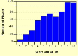
7 / 10
Plays
2949
Awards
Top 10% Quiz
Last 3 plays: Linda_Arizona (8/10), mickeyp (7/10), Guest 68 (7/10).
-
Question 1 of 10
1. This country is the most northern country in all of Africa, and its city of Kairouan is most important to the Muslim world. The city of Carthage was founded within its borders. Tourists, particularly European ones, flock to this country not only for its beautiful Mediterranean beaches but also for tours of Roman ruins and camel rides into the Sahara. What country is this? Hint


Question 2 of 10
2. These tropical islands are a British Overseas Territory. As there are no lakes and rivers, all living on the island must depend on rainfall or desalinated water for drinking. The islands are home to the Conch Bar Cave system, several underwater cave systems like the Cottage Pond and the Boiling Hole, and a humpback whale migration site. What is this island nation, whose capital is Cockburn Town? Hint


Question 3 of 10
3. This republic is the smallest Central Asian country, possessing approximately 55,251 square miles, and 90% of its surface area is composed of mountains, from which many have claimed to see the fabled Yeti. While the country established independence in 1991, parts of it have been occupied since 3,000 BC. What is this nation whose city of Khodjand was on the Silk Road? Hint


Question 4 of 10
4. This Polynesian nation is the fourth smallest sovereign nation in the world, according to area, and has the third smallest population of any nation. In fact, in 2014, its capital city had only around 4,490 inhabitants. Though sparsely populated, it has a long history of human life; its Nanumanga cave system may have been occupied by human beings as early as 5,000 BC. What is the name of this member of the British Commonwealth? Hint


Question 5 of 10
5. This nation interestingly contains both the highest and lowest points in all of Africa--the peak of Mount Kilimanjaro and the floor of Lake Tanganyika. It also is the only country to have set aside over 25% of its land to conservation and parks (all of that land put together would be equal to the size of Germany and Belgium combined!). What is the name of this country that shares its borders with both Lake Victoria and the Indian Ocean? Hint


Question 6 of 10
6. This city was founded in 1536 as a mining town and became its country's capital in 1880. It also served as the capital of the very short-lived Republic of Central America. The old part of town is built on a steep hill and still retains Spanish colonial aspects, including narrow streets, stair-stepped streets, and overhanging balconies. What is the name of this city, which can be found in the country highlighted in the map? Hint


Question 7 of 10
7. This city rests at a height of 7600 on a hillside in a valley of the Wang Chhu. It is one of the few world capitals not served by an airport, is the only world capital with no traffic lights, and remains one of the smallest world capitals. This lack of modernization and urbanization is a result of its people's commitment to Buddhism. What is the name of this city, which can be found in the country highlighted in the map? Hint


Question 8 of 10
8. In this capital city, one can visit The Block, a fashionable area created under the country's previous communist regime to provide families of the ruling party members a place to escape life for a while. Following the end of the country's communist dictatorship, it is now home to several shops, cafes, restaurants, pubs, and clubs as well as a thriving night life. Of interest is Boulevard Deshmoret e Kombit, which leads to the Italian square and a statue of Mother Teresa. What is the name of this city, which can be found in the country highlighted in the map? Hint


Question 9 of 10
9. This capital city and textile center has one of the largest cotton mills in Asia. It also has been occupied by Arabs, Turks, Mongols, and Russians. Of note, the city has one of the most beautiful metro systems in the world as it features chandeliers, granite, engraved metal, and marble ceilings and pillars, with each station having its own unique theme. Also, the city's Telyashayakh Mosque holds the oldest existing copy of the Qur'an. What is the name of this city, which can be found in the country highlighted in the map? Hint


Question 10 of 10
10. Originally founded by the Phoenicians, this capital city is so large that over one third of the entire country's inhabitants live there. The city was under Italian rule from 1912 to 1947; then following World War II, it was under British control until the country gained its independence in 1951. It also is home to the Arch of Marcus Aurelius, a monument that serves as the only significant visible remainder of Roman occupation from the second century. What is the name of this city, which can be found in the country highlighted in the map? Hint


(Optional) Create a Free FunTrivia ID to save the points you are about to earn:

arrow Select a User ID:
arrow Choose a Password:
arrow Your Email:


View Image Attributions for This Quiz

Most Recent Scores
Dec 08 2024 : Linda_Arizona: 8/10
Nov 13 2024 : mickeyp: 7/10
Nov 11 2024 : Guest 68: 7/10

Score Distribution

quiz
Quiz Answer Key and Fun Facts
1. This country is the most northern country in all of Africa, and its city of Kairouan is most important to the Muslim world. The city of Carthage was founded within its borders. Tourists, particularly European ones, flock to this country not only for its beautiful Mediterranean beaches but also for tours of Roman ruins and camel rides into the Sahara. What country is this?

Answer: Tunisia

The northern tip of Tunisia juts into the Mediterranean sea, thus making the country the most northern of all of Africa's countries. Its Mediterranean coast line makes it a popular tourist destination, and many enjoy particularly the city of Hammamet. Of course, many are also drawn to its historical sites, and there are plenty of them from Carthage to many ancient ruins dating back to Roman occupation. Tunisia is also significant for religious reasons.

The city of Kairouan is the fourth most important city to those of the Muslim faith, following Mecca, Medina, and Jerusalem. Founded around 670 AD, Kairouan became an important center for Islamic and Quranic learning, and the Great Mosque of Sidi-Uqba is located there.

The country's landscape is quite diverse from temperate coast lines to fertile agricultural land to the northern reaches of the Atlas Mountains and the Sahara Desert.
2. These tropical islands are a British Overseas Territory. As there are no lakes and rivers, all living on the island must depend on rainfall or desalinated water for drinking. The islands are home to the Conch Bar Cave system, several underwater cave systems like the Cottage Pond and the Boiling Hole, and a humpback whale migration site. What is this island nation, whose capital is Cockburn Town?

Answer: Turks and Caicos

Forty thousand people live on the Turks and Caicos Islands, located southeast of the Bahamas and north of Haiti. While there are eight main islands and two hundred and ninety-nine smaller ones, most of the population live in the Caicos Island region on the island of Providenciales, where the capital Cockburn is located.

The Turk Islands are named for their pirate history ("Turk" was once a synonym for "pirate"), and the Caicos Islands are named from the Lucayan words "Caya Hico", which mean "string of islands".

The Lucayans are the native islanders that lived in the Caribbean before European settlers. The island system also contains the third largest barrier reef system in the world.
3. This republic is the smallest Central Asian country, possessing approximately 55,251 square miles, and 90% of its surface area is composed of mountains, from which many have claimed to see the fabled Yeti. While the country established independence in 1991, parts of it have been occupied since 3,000 BC. What is this nation whose city of Khodjand was on the Silk Road?

Answer: Tajikistan

"Tajikistan" translates to "land of the Tajiks", a pre-Islamic people probably of Persian ancestry. The land within the current boundaries of Tajikistan has been occupied by many external forces, including those of the Samanid Empire, Alexander the Great, Genghis Khan, and Russia (later the Soviet Union).

The Iskanderkul Lake was named for Alexander the Great. In 2014, it remained the poorest nation in Central Asia, and in 2004 the United States of America helped its people build a bridge between the country and Afghanistan to improve Tajikistan's connection with South Asia and improve its economy.

The ancient city of Sarazm is a UNESCO World Heritage site, and its existence dates back to the fourth millennium BCE, when it was most likely the largest mining center of Central Asia.
4. This Polynesian nation is the fourth smallest sovereign nation in the world, according to area, and has the third smallest population of any nation. In fact, in 2014, its capital city had only around 4,490 inhabitants. Though sparsely populated, it has a long history of human life; its Nanumanga cave system may have been occupied by human beings as early as 5,000 BC. What is the name of this member of the British Commonwealth?

Answer: Tuvalu

The island nation of Tuvalu consists of three reef islands and six atolls. It is located in the Polynesian area of the South Pacific, and 96% of its population is of Polynesian ethnicity with the majority of the remaining 4% being of Micronesian ethnicity.

The name "Tuvalu" comes from the Tuvaluan phrase meaning "eight standing together", a phrase referring to the eight inhabited islands. The Caves of Nanumanga are an underwater cave system several meters down a coral cliff; remarkably, evidence suggests that humans may have lived in them several thousands of years ago when the sea level was lower and the island was perhaps higher as well. Tuvalu was once referred to as Ellice Islands; however, following a referendum in 1974, the island colony became an independent nation in 1976 and was then called Tuvalu. Because of the same referendum, the nearby Gilbert Islands colony also became the independent nation Kiribati.
5. This nation interestingly contains both the highest and lowest points in all of Africa--the peak of Mount Kilimanjaro and the floor of Lake Tanganyika. It also is the only country to have set aside over 25% of its land to conservation and parks (all of that land put together would be equal to the size of Germany and Belgium combined!). What is the name of this country that shares its borders with both Lake Victoria and the Indian Ocean?

Answer: Tanzania

The area demarcated by Tanzania's borders was occupied by human beings as early as 10,000 years ago, and the semi-autonomous island of Zanzibar (or Unguja) has been occupied by humans for at least 20,000 years. Tanzania's Serengeti plains are part of the migration route for the white-bearded wildebeest and other species of the Bovidae family, and the country is home to over 275 reptiles and 130 amphibians. Of course, it is also famous for Gombe Stream National Park, the site of Jane Goodall's studies of chimpanzees. Mount Kilimanjaro, made famous in American culture because of Ernest Hemingway's story "The Snows of Kilimanjaro", is a dormant volcano consisting of three cones.
6. This city was founded in 1536 as a mining town and became its country's capital in 1880. It also served as the capital of the very short-lived Republic of Central America. The old part of town is built on a steep hill and still retains Spanish colonial aspects, including narrow streets, stair-stepped streets, and overhanging balconies. What is the name of this city, which can be found in the country highlighted in the map?

Answer: Tegucigalpa

Some claim the name "Tegucigalpa" comes from the Nahuatl word for "hills of silver", a fitting name for a town born into the mining business. Other scholars question this because they find it difficult to believe the Nahuatl knew anything about the ore-rich land so long ago when the area was given this name; instead, they argue that the name means "in the homes of the sharp stones". Tegucigalpa is not only Honduras' capital, but it is also the nation's largest and most populous city.

Despite the city's location within a mountain chain, much of it is located within a valley, and the city is split by a river that runs through it.

These situations cause the city to be prone to flooding and account for why it received so much damage during Hurricane Mitch in 1998.

In 2014, the city still had places that had not recovered or been repaired after this destructive force of nature. The city lacks the financial funding for the proper engineering of levees to prevent the river's flooding, and several neighborhoods are listed in danger zones; a few neighborhoods have even been deemed completely uninhabitable.

Despite these problems, the city is home to many historical and architectural sites of interest, such as the Basilica of Our Lady of Suyapa, the St. Michael Archangel Cathedral, and the Plaza Morazán.
7. This city rests at a height of 7600 on a hillside in a valley of the Wang Chhu. It is one of the few world capitals not served by an airport, is the only world capital with no traffic lights, and remains one of the smallest world capitals. This lack of modernization and urbanization is a result of its people's commitment to Buddhism. What is the name of this city, which can be found in the country highlighted in the map?

Answer: Thimphu

Thimphu, the capital and largest city of Bhutan, suffers a rainy season that lasts from May to September and often dumps 20 to 30 inches of rain per year. This constant rain causes thick mud, deep puddles, landslides that block roads, and heightened rivers clogged with debris from surrounding forests. Thimphu is famous for its National Post Office, where the Bhutan Philatelic Bureau sells unique stamps that are sought by collectors all over the world. Of further interest is the Motithang Takin Preserve, which is a wildlife preserve that protects the takin, a member of the sheep family unique to that area of Asia and Bhutan's national animal.
8. In this capital city, one can visit The Block, a fashionable area created under the country's previous communist regime to provide families of the ruling party members a place to escape life for a while. Following the end of the country's communist dictatorship, it is now home to several shops, cafes, restaurants, pubs, and clubs as well as a thriving night life. Of interest is Boulevard Deshmoret e Kombit, which leads to the Italian square and a statue of Mother Teresa. What is the name of this city, which can be found in the country highlighted in the map?

Answer: Tirana

Tirana is the largest city of Albania and became its capital in 1920. The city is surrounded by hills, for the most part, and Mount Dajt can be seen to the east. Dajti Mountain has been declared a national park, and as it is often covered in snow during the winter months, it provides a popular recreational getaway for the people of Tirana, which hardly receives any snow at all.

The area of Tirana has been occupied by human life for 10 to 30 thousand years, as is made evident by primitive tools that have been found near Mount Dajt as well as in the nearby Pellumba Cave. During World War II, Tirana was occupied by Italian fascists, but communist forces began to grow in power, which led to a battle between German Nazi forces and communist forces in November of 1944.

The Nazi forces eventually withdrew, and the communists emerged as the controlling power with Enver Hoxha as its leader.
9. This capital city and textile center has one of the largest cotton mills in Asia. It also has been occupied by Arabs, Turks, Mongols, and Russians. Of note, the city has one of the most beautiful metro systems in the world as it features chandeliers, granite, engraved metal, and marble ceilings and pillars, with each station having its own unique theme. Also, the city's Telyashayakh Mosque holds the oldest existing copy of the Qur'an. What is the name of this city, which can be found in the country highlighted in the map?

Answer: Tashkent

Tashkent is the capital city of Uzbekistan. In 1219, the city was destroyed by Genghis Khan and his troops, but it was later rebuilt and began to thrive because of the Silk Road. In the 1800s, Uzbekistan was taken by the Russians, and in the 1900s Tashkent again began to thrive because of Soviet influence. Tashkent experiences an interesting climate because of its location; most of the year, the climate is like that of the Mediterranean with long dry summers, but its short winters are more like the continental climate with two to three months of cold and snowy days. Tashkent is home to the Chorsu Bazaar, a huge open-air market, and the Palace of Prince Romanov, where Nikolai Konstantinovich, the grandson of Nicholas I, was banished after he stole some crown jewels to give to his American love interest Fanny Lear.
10. Originally founded by the Phoenicians, this capital city is so large that over one third of the entire country's inhabitants live there. The city was under Italian rule from 1912 to 1947; then following World War II, it was under British control until the country gained its independence in 1951. It also is home to the Arch of Marcus Aurelius, a monument that serves as the only significant visible remainder of Roman occupation from the second century. What is the name of this city, which can be found in the country highlighted in the map?

Answer: Tripoli

Tripoli is, obviously, also Libya's largest city, and as a port city on the Mediterranean, it has the nicknames of "The Mermaid" and "Bride of the Sea". Tripoli was founded in 7 BC by Phoenicians from Tyre, but the city was called "Oea" at that time. "Tripoli" comes from "Tripolis", the Greek for "three cities", which refers to the fact that the current Tripoli is a combination of Oea, Sabrata, and Leptis Magna.

The city has been occupied and controlled by many foreign forces over the centuries, starting with the Romans, and then the vandals, the Arabs, the Spanish, the Ottomans, the Italians, and then the British. Libya was then under the leadership of a king until the uprising led by Muammar al-Gaddafi, who became the country's president until he was ousted from power and killed in 2011. During Gaddafi's reign, Tripoli was bombed by American forces in April of 1986.

These bombings were ordered by President Ronald Reagan after the CIA produced information that Gaddafi had been behind the bombing of a West Berlin discotheque frequented by American servicemen.
Source: Author alaspooryoric

This quiz was reviewed by FunTrivia editor spanishliz before going online.
Any errors found in FunTrivia content are routinely corrected through our feedback system.
Related Quizzes
1. Several 'V' Destinations Easier
2. 'X'isting Places Easier
3. X Marks the Spot Average
4. Y in the World? Average
5. 'X' Helps Indicate the Spot! Average
6. A World Search for U Average
7. Z end of the World Average
8. World Wise aka World Ys Average
9. X International Quiz Average
10. W International Quiz Average
11. U International Quiz Average
12. From Z to Shining Z Average

12/26/2024, Copyright 2024 FunTrivia, Inc. - Report an Error / Contact Us