FREE! Click here to Join FunTrivia. Thousands of games, quizzes, and lots more!
Quiz about Quirky New Zealand The Other Down Under

Quirky New Zealand: The Other Down Under Quiz


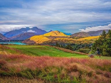
New Zealand is unfairly bracketed with Australia as being another "Down Under". Just as its people are culturally different from Australians, so is its geography. This quiz highlights New Zealand's unique physical geography.

A multiple-choice quiz by 1nn1. Estimated time: 4 mins.
  1. Home
  2. »
  3. Quizzes
  4. »
  5. Geography Trivia
  6. »
  7. Pacific Islands
  8. »
  9. New Zealand

Author
1nn1
Time
4 mins
Type
Multiple Choice
Quiz #
387,702
Updated
Dec 03 21
# Qns
10
Difficulty
Average
Avg Score
7 / 10
Plays
1899
Awards
Top 5% quiz!
Last 3 plays: robbonz (7/10), Guest 106 (8/10), Guest 208 (9/10).
- -
Question 1 of 10
1. New Zealand is often classified as having two main islands and a "number of smaller islands". The third largest island is Stewart Island. Where is it located relative to the two main islands? Hint


Question 2 of 10
2. There are not many people in New Zealand, with only a handful of cities, with only four that have populations above 200 000 people. Which is the only one of the four located on the South Island? Hint


Question 3 of 10
3. New Zealand, an island country with many inlets and bays, is in the top ten of countries in the world with the largest coastlines.


Question 4 of 10
4. The Treaty of Waitangi, signed in 1840, was an important document in the identity of New Zealand's cultural history. Where is Waitangi situated? Hint


Question 5 of 10
5. If you visit the charming city of Napier on the east coast of the North Island, many of the buildings in the inner city area appear to be Art Deco in style. What influenced this disproportionate representation of this style of architecture? Hint


Question 6 of 10
6. One of New Zealand major cities has a proud Scottish heritage. In fact it is named after Edinburgh itself. What is the name of this southern city? Hint


Question 7 of 10
7. Almost expectedly, the waters around New Zealand are named after explorers: Tasman Sea; Cook Strait, you get the picture. So it follows that the Foveaux Strait which separates Stewart Island from the "mainland" is also named after an explorer.


Question 8 of 10
8. One key physical difference between Australia and New Zealand is that New Zealand is as mountainous as Australia is flat. What European sounding name is the steep mountain range that bisects the South Island? Hint


Question 9 of 10
9. It was become an overused joke that New Zealand has more sheep than people but is New Zealand one the world's top five countries by number of heads of sheep?


Question 10 of 10
10. New Zealand is situated more south than the Great Southern Land of Australia. However it is a long narrow country. Cape Reinga is (incorrectly) thought to be the northern tip of New Zealand. It is approximately the same latitude as which big Australian city? Hint


(Optional) Create a Free FunTrivia ID to save the points you are about to earn:

arrow Select a User ID:
arrow Choose a Password:
arrow Your Email:


Most Recent Scores
Jan 20 2025 : robbonz: 7/10
Jan 20 2025 : Guest 106: 8/10
Jan 15 2025 : Guest 208: 9/10
Dec 29 2024 : psnz: 10/10
Dec 23 2024 : Guest 47: 10/10
Dec 12 2024 : Guest 87: 1/10
Dec 04 2024 : Guest 161: 8/10

Score Distribution

quiz
Quiz Answer Key and Fun Facts
1. New Zealand is often classified as having two main islands and a "number of smaller islands". The third largest island is Stewart Island. Where is it located relative to the two main islands?

Answer: Off the southern tip of the South Island

The North and South Islands are the 14th and 12th largest islands in the world respectively. Stewart Island is quite a bit smaller at 1,746 sq km. It represents 0.6% of New Zealand's land mass. It has a steady population of less than 400 and most live in the only settlement of Oban.

The island's Maori name, Te Punga o Te Waka a Maui, means "The Anchor Stone of Maui's Canoe". This places the island in the forefront of Maori mythology.
2. There are not many people in New Zealand, with only a handful of cities, with only four that have populations above 200 000 people. Which is the only one of the four located on the South Island?

Answer: Christchurch

Before a city can be proclaimed a city in New Zealand, it needs to have 50 000 people. With a population of less than five million this means in 2016 there were only thirteen "qualified" cities. Only a quarter of New Zealanders live on the larger South Island with over half living in the two largest cities Christchurch (390 000 - 2016 census) and Dunedin (119 000 - 2016 census). About a third live in greater Auckland (1 495 000) and another 405 000 in the capital Wellington.

The country's fourth largest city, Hamilton, situated in north central North Island, had 230 0000 people in the 2016 census.
3. New Zealand, an island country with many inlets and bays, is in the top ten of countries in the world with the largest coastlines.

Answer: True

With a coastline of 15,134km, this is the nine largest coastline in the world according to the CIA World Factbook. New Zealand's neighboring cousin, Australia (ranked sixth) has an area 28 times larger than NZ yet its coastline is not even double that of NZ.
Besides its "double island geography", one of the major reasons why NZ has such a large coastline is the number of fjords on the western coast of the South Island.
4. The Treaty of Waitangi, signed in 1840, was an important document in the identity of New Zealand's cultural history. Where is Waitangi situated?

Answer: In the Bay of Islands, north of Auckland

Waitangi (Maori for weeping waters) is a locality in the Bay of Islands in the far north of the North Island. In 1840, the treaty was signed by agents of the British Crown (led by Lieutenant Governor William Hobson) and many Māori chiefs from the North Island.

This resulted in the declaration of British sovereignty over New Zealand. It stayed a part of New South Wales until self-government as a separate colony came in 1841. The first capital was supposed to be established on the site but it was established at Russell, a few kilometers to the south. February 6th is celebrated by all New Zealanders as a public holiday as Waitangi Day.
5. If you visit the charming city of Napier on the east coast of the North Island, many of the buildings in the inner city area appear to be Art Deco in style. What influenced this disproportionate representation of this style of architecture?

Answer: Earthquake in 1931

The clue here was 1931: The Art Deco era took place in 1925-1939. In 1931 an earthquake devastated the coastal town of Napier (New Zealand is situated in the Ring of Fire). As the town had to be rebuilt, buildings were constructed in the style of the day, Art Deco. Some Art Deco buildings were replaced with conventional architecture in the 1950s-70s but by the 90s, there was considerable interest in retaining the architecture and the buildings were protected under heritage legislation .

Napier and South Beach in Miami Beach, Florida, are considered to be the two best-preserved Art Deco towns.
6. One of New Zealand major cities has a proud Scottish heritage. In fact it is named after Edinburgh itself. What is the name of this southern city?

Answer: Dunedin

Dunedin: the name comes from Důn Čideann, the Scottish Gaelic name for Edinburgh which, in turn, is an anglicised version of the Scottish capital with "burgh" being a literal translation of the Gaelic "dun" which means fort). Therefore one could argue Dunedin is more Scottish than Edinburgh!

In 1844 Captain Thomas Wing, of the sailing ship "Deborah", his wife Lucy and a representative of the New Zealand Company, Frederick Tuckett, sailed south to find a suitable site for a settlement for the Free Church of Scotland. In 1848, Dunedin was settled by Scottish immigrants at the head of Otago Harbour in 1848. Gold was discovered in the region in 1852 which attracted immigrants from Ireland, Italy, Lebanon, France, Germany, and China. Despite this influx causing Dunedin to be New Zealand's biggest city by 1865, the city remained proudly Scottish. Today Dunedin is the seventh largest city in New Zealand but is still considered one of the four most important cities for historic, cultural and geographic reasons.
7. Almost expectedly, the waters around New Zealand are named after explorers: Tasman Sea; Cook Strait, you get the picture. So it follows that the Foveaux Strait which separates Stewart Island from the "mainland" is also named after an explorer.

Answer: False

Foveaux Strait (Maori name: Te Ara a Kewa which means "the path of the southern right whales") is about 70km long and between 15-50 km wide, separating Stewart Island from the southern tip of the South Island. It was discovered by Captain Cook in 1770 but he thought Stewart Island was part of the South Island.

It was not named until 1804, when discoverer Owen Folger Smith discovered it was a seaway and perhaps disappointingly did not name it after himself, but named after Joseph Foveaux, Lieutenant-Governor of New South Wales in 1808-1809. The strait is the centre of the Bluff (coastal town on the South Island) oyster trade. Oysters from this area are world famous.

The Strait is also treacherous, with many seafaring lives been lost in the region.
8. One key physical difference between Australia and New Zealand is that New Zealand is as mountainous as Australia is flat. What European sounding name is the steep mountain range that bisects the South Island?

Answer: Southern Alps

The Southern Alps extend 500km down the "spine" of the South Island, almost its entire length. The range acts as a moderator of the climatic conditions either side of the range. The tallest peak is Aoraki (Mt Cook) at 3,724 metres (12,218 ft). Additionally there are twelve other peaks greater than 3000 metres high. There are over 3000 glaciers within its confines and the climate is cold with all year snow on the highest peaks.

The peaks were named by Captain Cook in 1770 but they were also observed by Abel Tasman in 1642.
9. It was become an overused joke that New Zealand has more sheep than people but is New Zealand one the world's top five countries by number of heads of sheep?

Answer: No

While it is a fact that there are more sheep than people in New Zealand, this is not saying much when there are less than five million people! In 2014, the top five countries in sheep head count were, in descending order, China 202 million, Australia 72 million, India 63 million, Iran 50 million, and Nigeria 41 million, Each of these countries except Australia have large populations so it is fair to say, New Zealand has more sheep per capita than any of the "Big five".
However both Australia and New Zealand are in the top five when it comes to wool and sheep meat production. Australia produces 25% of the world's wool, China 18%, USA 17% and New Zealand 11%. The largest producers of sheep meat (lamb, hogget, mutton) in 2013 were mainland China (2 million sheep), Australia (660,000), New Zealand (450,000), Sudan (325,000), and Turkey (295,000).

One of the reasons both New Zealand and Australia have such large sheep populations is because of their distance from Europe. They needed a commodity that wouldn't spoil with time and distance when transported to Europe. Wool was one of the few natural commodities that fit this criterion.
10. New Zealand is situated more south than the Great Southern Land of Australia. However it is a long narrow country. Cape Reinga is (incorrectly) thought to be the northern tip of New Zealand. It is approximately the same latitude as which big Australian city?

Answer: Sydney

Cape Reinga is sentimentally known as the northern tip of New Zealand as it is considered to be a separation marker between the Tasman Sea to the west and the Pacific Ocean to the east. Certainly from the lighthouse at the tip you can see the two currents clashing.

The actual northern tip is Surville Cliffs, North Cape, a few kilometres to the east. Cape Reinga is at 34.2 degrees South, 2190km to the south is the city of Invercargill at 46.6 degrees South, showing how long New Zealand is. So far north is Cape Reinga, it is very similar to the coordinates of Sydney (33.9S). Auckland (36.5S) is similar to Melbourne (37.8S) and Christchurch (43.5S) is a bit father south than Hobart (42.88 S).
Source: Author 1nn1

This quiz was reviewed by FunTrivia editor agony before going online.
Any errors found in FunTrivia content are routinely corrected through our feedback system.
1/22/2025, Copyright 2025 FunTrivia, Inc. - Report an Error / Contact Us