FREE! Click here to Join FunTrivia. Thousands of games, quizzes, and lots more!
Quiz about The Landlocked Kingdom of Lesotho

The Landlocked Kingdom of Lesotho Quiz


Basutoland was renamed the Kingdom of Lesotho upon independence from the United Kingdom in 1966. Its name means 'land of the people who speak Sesotho', a Bantu language spoken by 90% of the Basotho. Come explore their land.

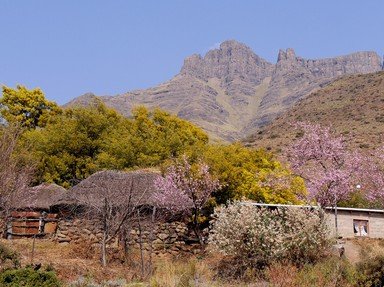
A multiple-choice quiz by looney_tunes. Estimated time: 4 mins.
  1. Home
  2. »
  3. Quizzes
  4. »
  5. Geography Trivia
  6. »
  7. Africa
  8. »
  9. Lesotho

Author
looney_tunes
Time
4 mins
Type
Multiple Choice
Quiz #
324,699
Updated
Dec 03 21
# Qns
10
Difficulty
Average
Avg Score
8 / 10
Plays
4736
Awards
Top 5% quiz!
- -
Question 1 of 10
1. In 2006, Lesotho celebrated 40 years of independence with a new flag. What unusual symbol is found on this flag? Hint


Question 2 of 10
2. Lesotho is the southernmost landlocked country in the world, being completely surrounded by South Africa. What is the name given to a country which is completely surrounded by another country? Hint


Question 3 of 10
3. With an area just over 30,000 sq km (11,600 sq mi), the Kingdom of Lesotho is approximately the same size as which of these European countries? Hint


Question 4 of 10
4. What is the terrain of Lesotho like? Hint


Question 5 of 10
5. How is the climate of Lesotho best described? Hint


Question 6 of 10
6. The lowest point in Lesotho has an elevation of 1400 m (4600 ft) above sea level. At the junction of what two rivers is this point located? Hint


Question 7 of 10
7. Where is the highest point in the kingdom of Lesotho? Hint


Question 8 of 10
8. Which of the following natural hazards is a problem for the residents of Lesotho? Hint


Question 9 of 10
9. What is the most important natural resource for the people of Lesotho? Hint


Question 10 of 10
10. Lesotho is one of the poorer countries in the world, with 49% of its population living below the poverty line in 2000, and an unemployment rate of 45% in 2002. With most families engaged in subsistence agriculture as their major economic activity, how have many men obtained a cash income for their families since the start of the 21st century? Hint


(Optional) Create a Free FunTrivia ID to save the points you are about to earn:

arrow Select a User ID:
arrow Choose a Password:
arrow Your Email:


Most Recent Scores
Nov 06 2024 : Johnmcmanners: 10/10
Sep 29 2024 : BardAsh85: 9/10

Score Distribution

quiz
Quiz Answer Key and Fun Facts
1. In 2006, Lesotho celebrated 40 years of independence with a new flag. What unusual symbol is found on this flag?

Answer: Black hat, representing the indigenous Basotho people

Lesotho's new flag has three horizontal stripes: blue on top, white in the middle, and green on the bottom, with the white stripe one-third wider than the others. These stripes represent rain, peace and prosperity, all of which, unfortunately, are not always plentiful in Lesotho. The central stripe bears a black Basotho hat, representing the indigenous people of the country.
2. Lesotho is the southernmost landlocked country in the world, being completely surrounded by South Africa. What is the name given to a country which is completely surrounded by another country?

Answer: Enclave

An enclave is a country that is completely surrounded by another country, while an exclave is a piece of a country that is physically separated from the rest of the country. Inclaves and outclaves don't exist!

Basutoland (as it was then known) was originally established as a political entity by Great King Moshoeshoe I in 1822. After conflicts with Boer settlers, it gained the status of a British protectorate, although the establishing Treaty of Aliwal in 1869 gave half of its original territory to the Boers. Lesotho's border with South Africa is 909 km (565 mi) long.
3. With an area just over 30,000 sq km (11,600 sq mi), the Kingdom of Lesotho is approximately the same size as which of these European countries?

Answer: Belgium

The area of Lesotho is 30,355 sq km, which is very close to the same as that of Belgium, 30,510 sq km, and slightly smaller than the American state of Maryland (32,134 sq km). It is also similar in size to the Republic of China, commonly known as Taiwan, which has an area of 35,980 sq km.

The areas of the other countries listed are: Italy 301,230 sq km; Greece 131,940 sq km; Liechtenstein 160 sq km.
4. What is the terrain of Lesotho like?

Answer: Hills and mountains

One of the highest countries in the world, Lesotho is made up of highland plateaus, hills and mountains. More than 80% of the country is over 1,800 m (5,900 ft) above sea level.

A savanna is a grassland ecosystem with trees that are too widely separated to form a canopy. The Serengeti in Tanzania, with its abundant wildlife, is a typical savanna. Glaciated landscapes are found in Norway, amongst other places. A steppe is a grassland plain with few or no trees, such as is found is southwest Russia.
5. How is the climate of Lesotho best described?

Answer: Temperate

Temperate climates (in the Köppen-Geiger climate classification system) have an average temperature above 10 °C (50 °F) in their warmest months, and a coldest month average between -3 °C (26.6 °F) and 18 °C (64 °F). Lesotho's altitude means it is cooler than might be expected for its latitude, which places it just outside the tropics.

Its capital, Maseru, and the surrounding lower parts of the country can reach temperatures as high as 30 °C (86 °F) in summer. Winters are cold, and snow is common in the highlands between May and September. Lesotho's climate is also sometimes referred to as continental.
6. The lowest point in Lesotho has an elevation of 1400 m (4600 ft) above sea level. At the junction of what two rivers is this point located?

Answer: Orange and Makhaleng Rivers

The most notable geographic fact about Lesotho, apart from its status as an enclave, is that it is the only independent state in the world that lies entirely above 1,000 metres (3,200 ft) in elevation. Its lowest point, where the Makhaleng River joins the Orange River on the southwestern border, is the highest point of lowest elevation for any country.

The Makhaleng River valley forms part of the approach to a number of important mountain passes, including the beautifully-named God Help Me Pass and the Gates of Paradise Pass.
7. Where is the highest point in the kingdom of Lesotho?

Answer: Thabana Ntlenyana

The peak of Thabana Ntlenyana is the highest point in the country, at 3,482 m (11 424 ft) above sea level, as well as being the highest mountain in southern Africa. Thabana Ntlenyana, whose name means "Beautiful little mountain" in Sesotho, is situated on the ridge of the Drakensberg mountains near Sani Pass in Lesotho's east.

The second highest point in Lesotho is nearby Njesuthi, at 3446 m (11 306 ft). Maseru is the capital city of Lesotho, located on the Caledon River, bordering South Africa, in the country's northwest. Mohale's Hoek is a town near the lowest point of Lesotho, in the southwest.
8. Which of the following natural hazards is a problem for the residents of Lesotho?

Answer: periodic droughts

The annual precipitation in Lesotho varies between around 600 mm (24 in) in the lowland valleys to around double that amount in parts of the northeastern highlands. Most of the precipitation comes between October and April, in the form of summer thunderstorms. However, there is a lot of variability from year to year, which leads to periodic droughts.
9. What is the most important natural resource for the people of Lesotho?

Answer: Water

Water is the most important resource for Lesotho, with the Lesotho Highlands Water Project producing the electricity needs for Lesotho, as well as allowing for the export of water to South Africa. When completed, this project is expected to produce approximately 20% of Lesotho's Gross Domestic Product.

Diamonds from the Letseng diamond mine form the major mineral resource of Lesotho; it produces very few diamonds, but they are of excellent quality. Deposits of coal, galena, quartz, agate and uranium were not considered commercially viable at the start of the 21st century.
10. Lesotho is one of the poorer countries in the world, with 49% of its population living below the poverty line in 2000, and an unemployment rate of 45% in 2002. With most families engaged in subsistence agriculture as their major economic activity, how have many men obtained a cash income for their families since the start of the 21st century?

Answer: worked in South African mines for a few months every year

As of 2008, 75% of the population of Lesotho was located outside of urban areas. 86% of the Basotho families were engaged in subsistence agriculture, with 14% in industry and services. About a third of male wage earners worked in South African mines for 3-6 months each year to provide supplemental income. Agricultural products include corn, wheat, pulses, barley, sorghum and livestock.

The most fertile lands (to the north of the current border) were lost to South Africa in the Treaty of Aliwal in 1869; much of what remains is infertile and degraded due to soil erosion.
Source: Author looney_tunes

This quiz was reviewed by FunTrivia editor Exit10 before going online.
Any errors found in FunTrivia content are routinely corrected through our feedback system.
Related Quizzes
This quiz is part of series Written for the Bus Ride:

You think you can write just one, but it turns out that writing quizzes suitable for being visited by the tourists on the Bus Ride is addictive - there's just so much to find out!

  1. Saint Vincent and the Grenadines Average
  2. Barbados, Land of the Flying Fish Average
  3. Calypso Country - Trinidad and Tobago Average
  4. "The Land, the People, the Light" - Saint Lucia Average
  5. A Provincial Tour of Zimbabwe Average
  6. Republic of Benin, Formerly Dahomey Average
  7. The Landlocked Kingdom of Lesotho Average
  8. Honduras: "Free, Sovereign and Independent" Average
  9. Exploring Kosovo Average
  10. Democratic Republic of Sao Tome and Principe Average
  11. "We Stand With God" in Vanuatu Average
  12. They Came to Baghdad Average

11/21/2024, Copyright 2024 FunTrivia, Inc. - Report an Error / Contact Us