FREE! Click here to Join FunTrivia. Thousands of games, quizzes, and lots more!
Quiz about Wildrose Country Geography

Wildrose Country Geography Trivia Quiz


This quiz deals with the geography of that most beautiful of provinces, Alberta! Have fun!

A multiple-choice quiz by Team The Alberta Pioneers. Estimated time: 4 mins.
  1. Home
  2. »
  3. Quizzes
  4. »
  5. Geography Trivia
  6. »
  7. Canada
  8. »
  9. Alberta

Author
StetsonHat
Time
4 mins
Type
Multiple Choice
Quiz #
336,102
Updated
Dec 03 21
# Qns
15
Difficulty
Average
Avg Score
10 / 15
Plays
491
Last 3 plays: Guest 104 (12/15), Guest 74 (12/15), joker0321 (10/15).
- -
Question 1 of 15
1. What is the second largest city of Alberta? Hint


Question 2 of 15
2. What western town of Alberta is known for agriculture and has a model of a starship near Centre Street?

Hint


Question 3 of 15
3. How much coal was produced between 1912 and 1966 in Drumheller, Alberta? Hint


Question 4 of 15
4. Which of these mountain ranges is NOT situated in Alberta? Hint


Question 5 of 15
5. Lake Claire is the largest lake lying entirely in Alberta.


Question 6 of 15
6. What US state borders Alberta to the south? Hint


Question 7 of 15
7. There are glaciers in Alberta. What colour is glacial water? Hint


Question 8 of 15
8. What river rises in Banff National Park and flows for 587 km until it joins the Oldman River to form the South Saskatchewan River? Hint


Question 9 of 15
9. No rivers flow from Alberta into the Pacific Ocean.


Question 10 of 15
10. At what degree of northern latitude is Alberta's northern border located? Hint


Question 11 of 15
11. What Provincial Park classified as a UNESCO World Heritage site is located on the Red Deer River in the Badlands near the town of Brooks?

Answer: (One Word - It's extinct)
Question 12 of 15
12. After Southern Ontario, the central region of Alberta is the most likely place in Canada to experience what severe weather phenomenon? Hint


Question 13 of 15
13. There are two completely landlocked provinces in Canada. Alberta is one of them. What is the other? Hint


Question 14 of 15
14. Mount Alberta is the highest point in Alberta with an elevation of 3,747m.


Question 15 of 15
15. How many provincial parks does Alberta boast within its boundaries? Hint


(Optional) Create a Free FunTrivia ID to save the points you are about to earn:

arrow Select a User ID:
arrow Choose a Password:
arrow Your Email:


Most Recent Scores
Dec 08 2024 : Guest 104: 12/15
Dec 04 2024 : Guest 74: 12/15
Dec 02 2024 : joker0321: 10/15
Dec 02 2024 : portalrules123: 12/15
Nov 20 2024 : Guest 162: 9/15
Oct 25 2024 : Guest 129: 7/15

Score Distribution

quiz
Quiz Answer Key and Fun Facts
1. What is the second largest city of Alberta?

Answer: Edmonton

Edmonton is the second largest city of Alberta. It was incorporated as a city in 1904 and made provincial capital a year later. The largest city of the province however is Calgary, home of the annual Stampede.
2. What western town of Alberta is known for agriculture and has a model of a starship near Centre Street?

Answer: Vulcan

The town of Vulcan was named after the Roman God of Fire by a CPR surveyor. Many of its streets reflect this with names such as Juno, Neptune and Jupiter. The town chose to capitalize on the Vulcan - Star Trek connection to enhance tourism.
3. How much coal was produced between 1912 and 1966 in Drumheller, Alberta?

Answer: 56,864,808 tons

Drumheller Valley was a major source for coal production in Canada. Over a hundred mines existed from 1910 - 1979, however only 34 were active over a period of years.
4. Which of these mountain ranges is NOT situated in Alberta?

Answer: Big Sheep Mountains

The Big Sheep Mountains lie in eastern Montana. The Birch and the Caribou Mountains are both located in the far north of Alberta, while Cypress Hills straddle the Alberta - Saskatchewan border. The Rocky Mountains define much of the border with British Columbia in the southern part of the province.
5. Lake Claire is the largest lake lying entirely in Alberta.

Answer: True

Lake Claire has an area of 1346 square kilometres. It is located in Wood Buffalo National Park in northern Alberta. In the fur trade era its name was often recorded as Clear Lake. The town of Fort Chipewyan is located some 30 km to the east of the lake.
6. What US state borders Alberta to the south?

Answer: Montana

Montana is the only state that borders Alberta on the 49th parallel. It is a physically wide state, also bordering part of British Columbia and Saskatchewan. There are six border crossings between Alberta and Montana: Aden-Whitlash, Carway-Peigan, Del Bonita-Del-Bonita, Wild Horse-Wild Horse, Coutts-Sweetgrass, and Chief Mountain-Chief Mountain.
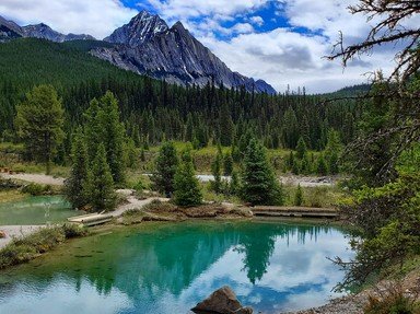
7. There are glaciers in Alberta. What colour is glacial water?

Answer: blue or green

Glacial water is bluish or greenish. This is because of "rock flour" in the water. The rock flour is small bits of minerals and rock that are in suspension due to the grinding of the glacier against the land. The particles refract the green or blue spectrum of sunlight making the water appear coloured.

In Alberta the glacial water is bluish because of the type of minerals making up the rock flour.
8. What river rises in Banff National Park and flows for 587 km until it joins the Oldman River to form the South Saskatchewan River?

Answer: Bow River

Flowing through Banff National Park with its start at the foot of Mount Gordon, the Bow River measures 623 kilometres in length. The Bow is important economically and recreationally. Apart from providing much needed water to people and farmland, the river winds its way through the centre of Calgary where many parks can be found along its banks.
9. No rivers flow from Alberta into the Pacific Ocean.

Answer: True

It's true because Alberta is located immediately east of the continental divide. For this reason, all of Alberta's rivers flow into either the Arctic Ocean, Hudson Bay, or the Gulf of Mexico.
10. At what degree of northern latitude is Alberta's northern border located?

Answer: 60 degrees

The southern border with the United States is at 49 degrees north latitude. The northern border of Alberta, with the Northwest Territories, is at 60 degrees north. That gives Alberta a difference of 11 degrees of latitude which is some 1223 km from north to south.
11. What Provincial Park classified as a UNESCO World Heritage site is located on the Red Deer River in the Badlands near the town of Brooks?

Answer: Dinosaur

Dinosaur Provincial Park contains some of the best preserved dinosaur remains in North America. It was declared a UNESCO World Heritage site in 1979. Apart from its extinct denizens, the park is also an important habitat for many bird species.
12. After Southern Ontario, the central region of Alberta is the most likely place in Canada to experience what severe weather phenomenon?

Answer: tornadoes

Tornadoes are a relatively common phenomenon on the prairies. Edmonton experienced a terrible tornado on July 31, 1987. It was bad enough to warrant a visit from the prime minister at the time, Brian Mulroney. Throughout the 20th century it turned out to be the second-deadliest tornado in Canadian history.
13. There are two completely landlocked provinces in Canada. Alberta is one of them. What is the other?

Answer: Saskatchewan

Manitoba is nearly landlocked, but it borders Hudson Bay to the northeast. Nunavut is not a province, it is a territory, and it definitely isn't landlocked. It is home to many islands and borders Baffin Sea, the Arctic Ocean, Hudson Bay, and Beaufort Sea. Ontario borders Hudson Bay to the north and the Great Lakes to the south.
14. Mount Alberta is the highest point in Alberta with an elevation of 3,747m.

Answer: False

Mount Columbia is the highest point in Alberta with an elevation of 3,747m while Mount Alberta measures in at 3,620m. Both peaks are located in Jasper National Park.
15. How many provincial parks does Alberta boast within its boundaries?

Answer: 75

Alberta has a total of 75 parks as well as recreational areas which cover 27,500 sq km. These areas include boreal forests, badlands, foothills, prairies and mountains. Fish Creek Provincial Park is the largest park within a city's boundaries.
Source: Author StetsonHat

This quiz was reviewed by FunTrivia editor Exit10 before going online.
Any errors found in FunTrivia content are routinely corrected through our feedback system.
12/21/2024, Copyright 2024 FunTrivia, Inc. - Report an Error / Contact Us