FREE! Click here to Join FunTrivia. Thousands of games, quizzes, and lots more!
Quiz about Brazils Natural Wonders

Brazil's Natural Wonders Trivia Quiz


Brazil is home to many of the world's incredible natural wonders. Here are ten such beauties in this interesting and informative photo quiz.

A photo quiz by trident. Estimated time: 3 mins.
  1. Home
  2. »
  3. Quizzes
  4. »
  5. Geography Trivia
  6. »
  7. South America
  8. »
  9. Brazil

Author
trident
Time
3 mins
Type
Photo Quiz
Quiz #
413,657
Updated
Dec 13 23
# Qns
10
Difficulty
Easy
Avg Score
9 / 10
Plays
285
Awards
Top 5% quiz!
-
Question 1 of 10
1. Iguazu Falls is easily one of the most beautiful locations on the planet, with its series of waterfalls (the largest system in the world) following a horseshoe-like row. The falls line the border between Brazil and what other large South American country? Hint


Question 2 of 10
2. Nearly 80% of this region's floodplains are underwater during rainy seasons, and it is home to countless plant and animal species. What is the name of this massive Brazilian wetland? Hint


Question 3 of 10
3. The Meeting of Waters in Manaus, Brazil, is a fascinating look at the confluence between the Solimões River (part of the Amazon) and the Rio Negro. Due to differences in the content of each body of water, a striking contrast is created. What is the cause of the brown-colored water?


Question 4 of 10
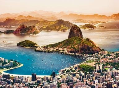
4. Sugarloaf Mountain, at the mouth of Guanabara Bay, is a popular location on which you can take a cable car. In which Brazilian city is it located? Hint


Question 5 of 10
5. The region of Jalapão, with its orange sand dunes, comprises the second largest hot desert on Earth after the Sahara.


Question 6 of 10
6. A popular locale for tourists, performers, and even athletes, which beach in Rio de Janeiro is flanked by two forts, one at each end? Hint


Question 7 of 10
7. With an elevation of 2,995 meters (9,827 ft) above sea level, Pico de Neblina is taller than Mount Aconcagua in Argentina.


Question 8 of 10
8. Due to the impermeable rock layer covering its base, Lençóis Maranhenses National Park is home to a large number of what natural features? Hint


Question 9 of 10
9. Known as "Diamond Plateau" in English, which region was once the world's largest diamond producer?


Question 10 of 10
10. The most common accounting of how the Amazon rainforest got its name is from which of the following, who encountered a tribe of female warriors? Hint


(Optional) Create a Free FunTrivia ID to save the points you are about to earn:

arrow Select a User ID:
arrow Choose a Password:
arrow Your Email:


View Image Attributions for This Quiz

Most Recent Scores
Dec 04 2024 : mermie316: 6/10
Nov 27 2024 : Guest 75: 7/10

Quiz Answer Key and Fun Facts
1. Iguazu Falls is easily one of the most beautiful locations on the planet, with its series of waterfalls (the largest system in the world) following a horseshoe-like row. The falls line the border between Brazil and what other large South American country?

Answer: Argentina

Iguazu Falls, known as "Cataratas do Iguaçu" in Portuguese, form a semi-circular shape that stretches for approximately 1.7 miles (2.7 kilometers), making it one of the widest waterfall systems in the world. The falls are situated within the Iguazu National Park, a UNESCO World Heritage Site, and are fed by the Iguazu River, which flows through the dense tropical rainforest of the region. The formation of Iguazu Falls dates back millions of years and is a result of geological processes involving volcanic activity and the shifting of tectonic plates. The falls consist of around 275 individual cascades, with the most famous one being the Devil's Throat, a massive U-shaped chasm that plunges dramatically into the abyss.

Iguazu Falls stands out among the world's waterfalls due to its unique combination of width and height, as well as its lush natural surroundings. While it may not be the tallest waterfall globally (that title goes to Angel Falls in Venezuela), Iguazu's awe-inspiring scale and its surrounding rainforest make it a breathtaking spectacle.
2. Nearly 80% of this region's floodplains are underwater during rainy seasons, and it is home to countless plant and animal species. What is the name of this massive Brazilian wetland?

Answer: Pantanal

Pantanal is one of the world's largest tropical wetland areas, covering an expanse of over 75,000 square miles. It was formed through a complex geological history involving the shifting course of the Paraguay River, which created a vast floodplain.

This region experiences distinct wet and dry seasons, characterized by dramatic fluctuations in water levels. The wet season sees heavy rains, while the dry season, from May to October, experiences significantly lower precipitation. During the rainy season, from November to March, much of Pantanal becomes submerged. This seasonal variation in water levels influences the region's wildlife and vegetation.

The Pantanal boasts a stunning array of flora and fauna, including over 1,000 bird species, 300 types of fish, and numerous reptiles and mammals. The wetlands are a haven for jaguars, capybaras, giant otters, and various species of colorful macaws and toucans. Aquatic plants, like water hyacinths and Victoria amazonica, thrive in the wetlands, while the surrounding savannahs are dotted with palms and hardwood trees.
3. The Meeting of Waters in Manaus, Brazil, is a fascinating look at the confluence between the Solimões River (part of the Amazon) and the Rio Negro. Due to differences in the content of each body of water, a striking contrast is created. What is the cause of the brown-colored water?

Answer: sediment from the Andes Mountains

The Meeting of Waters in Manaus, Brazil, is a remarkable natural phenomenon where two major rivers, the Solimões River and the Rio Negro, converge, but their waters do not immediately mix. This stunning occurrence is primarily due to differences in the rivers' temperature, speed, and composition.

The formation of the Meeting of Waters can be attributed to the distinct origins of these two rivers. The Rio Negro originates in Colombia and carries water that is rich in tannins and organic matter. This gives the Rio Negro its dark-colored appearance. On the other hand, the Solimões River (as part of the Amazon) with its origins in the Andes Mountains of Peru, carries sediment-laden water, resulting in a muddy brown color.

As these two mighty rivers meet, they run side by side for several miles without mixing. The key factor preventing immediate mixing is the significant difference in water temperatures. The Rio Negro flows at a cooler temperature, whereas the Amazon River is warmer. This temperature disparity, combined with the varying speed of the rivers, causes them to flow in parallel, maintaining a clear distinction between their dark and muddy waters.
4. Sugarloaf Mountain, at the mouth of Guanabara Bay, is a popular location on which you can take a cable car. In which Brazilian city is it located?

Answer: Rio de Janeiro

Sugarloaf Mountain, known as "Pão de Açúcar" in Portuguese, is an iconic landmark in the city of Rio de Janeiro. The name "Sugarloaf" can be traced back to the 16th century when the Portuguese first arrived in Brazil. The shape of the mountain, with its peak resembling the traditional shape of sugar loaves that were common in Europe at the time, led to the naming of the mountain.

This natural wonder was formed through geological processes millions of years ago, with the mountain primarily composed of granite and quartz. Sugarloaf Mountain stands at about 396 meters (1,299 feet) tall and is situated at the entrance of Guanabara Bay. One of the most exciting ways to experience Sugarloaf Mountain is by taking a cable car ride. The cable cars, which were inaugurated in 1912, transport visitors from the base to the summit. There are two cable car stages in this journey, providing panoramic views of the surrounding landscape, including the cityscape of Rio de Janeiro, Copacabana Beach, and the iconic Christ the Redeemer statue on Corcovado Mountain.
5. The region of Jalapão, with its orange sand dunes, comprises the second largest hot desert on Earth after the Sahara.

Answer: False

Jalapão, a microregion located in the Tocantins state of Brazil, is known for its unique natural beauty and diverse landscapes. Covering an area of approximately 34,000 square kilometers, it pales in comparison to the Sahara at 9 million sq. km and the Arabian Desert at 2.6 million sq. km. Jalapão is characterized by a semi-arid climate with scorching temperatures during the day and cooler nights. One of its most distinctive features is the striking orange sand dunes that stretch across its terrain, creating an otherworldly and desert-like atmosphere.

The region supports a variety of hardy plant species adapted to the arid conditions, such as golden grass (Capim Dourado), used by local artisans to craft beautiful jewelry and decorative items. Additionally, the cerrado biome found in Jalapão houses a plethora of native flora, including tall grasses, palms, and exotic flowering plants. The region shelters elusive creatures like jaguars, giant anteaters, and maned wolves, as well as numerous bird species, including toucans and parrots.
6. A popular locale for tourists, performers, and even athletes, which beach in Rio de Janeiro is flanked by two forts, one at each end?

Answer: Copacabana

Stretching for approximately 4.5 kilometers, Copacabana Beach boasts stunning views of the South Atlantic Ocean and is framed by the towering Sugarloaf Mountain and the hills of Rio's coastline. The beach holds an iconic crescent shape recognizable from the air. Fort Copacabana, on the southern end, was constructed in the early 20th century and now houses a military museum, offering a glimpse into Brazil's naval history. On the northern end is the Forte Duque de Caxias.

Visitors can often witness intense beach volleyball matches and soccer games played on the soft sands, reflecting Brazil's passion for these two sports. Samba music often fills the air as people perform lively dance sessions on the beach.
7. With an elevation of 2,995 meters (9,827 ft) above sea level, Pico de Neblina is taller than Mount Aconcagua in Argentina.

Answer: False

Pico da Neblina is the country's highest peak, rising in the Amazon Rainforest near the border with Venezuela. With an elevation of approximately 2,995 meters (9,827 feet) above sea level, it stands as the tallest mountain in Brazil. Comparatively, the mighty Aconcagua in Argentina, the highest peak in South America, reaches a towering height of 6,960 meters (22,837 feet), making it significantly taller than Pico da Neblina. The first documented ascent of Pico da Neblina took place in 1965 when a Brazilian military expedition successfully reached its summit.

The mountain's diverse ecosystem hosts a remarkable array of flora and fauna, including various species of orchids, bromeliads, and unique rainforest vegetation. Pico da Neblina's remote location and challenging terrain provide a habitat for elusive wildlife, such as jaguars, tapirs, and numerous bird species that can be unbothered by most human activities.
8. Due to the impermeable rock layer covering its base, Lençóis Maranhenses National Park is home to a large number of what natural features?

Answer: freshwater lagoons

What makes Lençóis Maranhenses National Park truly unique is the way it transforms during the rainy season. From January to June, heavy rains from the nearby Amazon Basin fill the depressions between the dunes with crystal-clear freshwater, creating thousands of dazzling lagoons. The park's stunning sand dunes, some towering as high as 40 meters, form intricate patterns that stretch as far as the eye can see. These dunes, sculpted by the relentless winds of the region, provide a constantly shifting and mesmerizing terrain.

Despite the harsh and arid environment, Lençóis Maranhenses is home to a surprising variety of flora and fauna. The lagoons support a rich aquatic ecosystem with small fish and amphibians. The surrounding vegetation includes hardy grasses, cacti, and succulents adapted to the extreme conditions. Bird enthusiasts can spot various species, including herons and seagulls, while migratory birds make the park a temporary home during certain seasons.
9. Known as "Diamond Plateau" in English, which region was once the world's largest diamond producer?

Answer: Chapada Diamantina

The formation of Chapada Diamantina, located in the heart of Bahia state in Brazil, is a result of geological processes spanning millions of years, including the uplift of ancient sea beds and volcanic activity, leading to the creation of its unique topography. Chapada Diamantina is known for its diverse range of rocks and minerals, with an abundance of quartz, amethyst, and agate. These gemstones have attracted prospectors and rock enthusiasts for generations.

In the 19th century, Chapada Diamantina was a major diamond mining hub, contributing significantly to Brazil's diamond production. The town of Lençóis, once a bustling center for diamond trade, serves as a vivid reminder of this era with its well-preserved colonial architecture.
10. The most common accounting of how the Amazon rainforest got its name is from which of the following, who encountered a tribe of female warriors?

Answer: a Spanish conquistador

The formation of the Amazon rainforest, the largest tropical rainforest in the world, dates back millions of years to when a combination of geological and climatic changes gave rise to this magnificent biome. Spanning nine South American countries, the Amazon Basin is home to a staggering array of flora and fauna. The Amazon rainforest teems with an estimated 390 billion individual trees belonging to around 16,000 species. The remarkable diversity of plant life includes towering canopy trees, medicinal plants like the Cinchona tree and exotic orchids. This lush habitat supports a vast range of animal species, from jaguars, sloths, and capybaras to vibrant birds like toucans and parrots.

One of the fascinating historical tales associated with the Amazon is the story of Francisco de Orellana. In 1541, while searching for the legendary city of gold, he embarked on a journey down the Amazon River. During his expedition, Orellana's party encountered a tribe of fierce female warriors, who inspired the river's and the rainforest's name - "Amazonas."
Source: Author trident

This quiz was reviewed by FunTrivia editor agony before going online.
Any errors found in FunTrivia content are routinely corrected through our feedback system.
12/22/2024, Copyright 2024 FunTrivia, Inc. - Report an Error / Contact Us