FREE! Click here to Join FunTrivia. Thousands of games, quizzes, and lots more!
Quiz about The Beauty of Brazil

The Beauty of Brazil Trivia Quiz


So you just returned from a trip to the wondrous South American land of Brazil where you took lots of pictures. Wait you haven't been to Brazil. Oh well, at least you can play this quiz and see some of the beautiful sights awaiting you in Brazil.

A photo quiz by adam36. Estimated time: 5 mins.
  1. Home
  2. »
  3. Quizzes
  4. »
  5. Geography Trivia
  6. »
  7. South America
  8. »
  9. Brazil

Author
adam36
Time
5 mins
Type
Photo Quiz
Quiz #
368,591
Updated
Dec 03 21
# Qns
10
Difficulty
Average
Avg Score
6 / 10
Plays
400
-
Question 1 of 10
1. In the north of Brazil, you will find the Ireng River amidst the rolling hills and valleys of the Pakaraima Mountains. The deep dark waters of the Ireng River form much of the border between Brazil and what northern neighbor? Hint


Question 2 of 10
2. About 200 km from the city of Sao Paulo is the Ilhabela Archipelago, including the largest island of Sao Sebastião. The island was named by the first European to visit in 1502. Who was the Italian explorer sailing for Portugal that was himself immortalized as the namesake for two continents?

Answer: (First and Last Name or Last Only)
Question 3 of 10
3. Located in the Tijuca Forest on top of Mt. Corcovado stands the 125 ft. (38m) tall statue known as "Christ the Redeemer" (Cristos Redenter). The statue was completed in 1931. In what then popular artistic style was the statue constructed? Hint


Question 4 of 10
4. The stunning Iguassu Falls is a series of 275 falls over a 1.67 mile (2.7 km) stretch of the Iguassu River. The start of the falls features a drop of 270 ft (82m) and is named Garganta do Diabo in Portuguese. What is the English name for this massive part of the Iguassu Falls? Hint


Question 5 of 10
5. Rio de Janeiro features some of the most famous and scenic beaches in Brazil and the world. Situated between the equally lovely Copacabana Beach and the pricey views along Leblon Beach is what beach area made famous in a song dedicated to a certain girl (and later boy)? Hint


Question 6 of 10
6. In contrast to the glorious beaches of Copacabana and Ipanema, there are many regions of Rio de Janeiro that are equally famous. One such place is the Rocinha Favela. What does "favela" translate to in English? Hint


Question 7 of 10
7. The Octávio Frias de Oliveira Bridge is a wonder of modern industrial architecture. The bridge is functional and instantly iconic. The bridge is unique in that a single concrete mast supports a double curved back. In what large Brazilian city can you find this X-shaped bridge? Hint


Question 8 of 10
8. In 1950, the population of the city of Brasilia was less than 36,000. By 2010 the city had increased population to over 2,150,000. What is the main reason for the tremendous growth in Brasilia's population?

Hint


Question 9 of 10
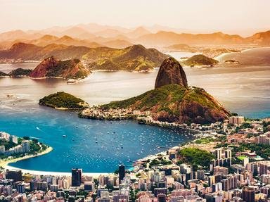
9. Looking out from Mt. Corcovado at the base of the Christ the Redeemer statute you see Guanabara Bay. What granite and quartz island rises from the blue water and has a glass cable car linking its twin peaks? Hint


Question 10 of 10
10. Deforestation of the Amazon River Basin remains a major concern for Brazil and environmentalists. Since 1980, over 224,000 square miles (580,000 square kilometers) of Amazon forest has been destroyed. What activity accounts for over half the reason for clearing these invaluable forests?

Hint


(Optional) Create a Free FunTrivia ID to save the points you are about to earn:

arrow Select a User ID:
arrow Choose a Password:
arrow Your Email:


View Image Attributions for This Quiz

Quiz Answer Key and Fun Facts
1. In the north of Brazil, you will find the Ireng River amidst the rolling hills and valleys of the Pakaraima Mountains. The deep dark waters of the Ireng River form much of the border between Brazil and what northern neighbor?

Answer: Guyana

The Ireng River is a tributary of the Amazon River that flows from north to south. For most of its length, the Ireng forms the border between Guyana and Brazil. Unlike much of the Amazon basin, the Ireng is a highland river that flows down from the Pakarima Mountains in northern Guyana and courses through grasslands and over sedimentary rock.

The rock gives the waters of the Ireng a darker color. The river's highlights include the spectacular 100 m tall Kurutuik Falls and the lovely Orinduik Falls.

While the Orinduik Falls are still impressive at 25m, they feature a series of tiered cascades that make the falls accessible for rafting or swimming.
2. About 200 km from the city of Sao Paulo is the Ilhabela Archipelago, including the largest island of Sao Sebastião. The island was named by the first European to visit in 1502. Who was the Italian explorer sailing for Portugal that was himself immortalized as the namesake for two continents?

Answer: Amerigo Vespucci

Amerigo Vespucci is an enigmatic name in the Age of Exploration. Vespucci is credited with participating in four voyages for Portugal during the early 16th century. Vespucci's contributions to the knowledge of the New World included evidence that the lands discovered by Columbus were not part of Asia but separate continents. After Vespucci published his research, mapmakers, in particular the 1507 works of Martin Waldseemüller, began referring to the new western landmass as Americus after Vespucci.

The Ilhabela Archipelago is a favorite area for boaters and scuba divers off the coast of Sao Paulo. During the summer months, the sleepy towns along the islands grow from 25,000 residents to over 100,000 as tourists flock to the warm waters. Scuba divers can explore fifty shipwrecks, and boaters can dock at one of forty one beaches along the coastal inlets.
3. Located in the Tijuca Forest on top of Mt. Corcovado stands the 125 ft. (38m) tall statue known as "Christ the Redeemer" (Cristos Redenter). The statue was completed in 1931. In what then popular artistic style was the statue constructed?

Answer: Art Deco

In Rio de Janeiro's urban Tijuco Forest, on top of the 710m Mt Corcovado (Hunchback Mountain), stands one of the truly magnificent artworks of the 20th century. The 125 ft tall statue of Jesus holding his arms out was built by the Catholic Circle of Rio with $250,000 in funds donated by people throughout Brazil.

The statue was designed by Brazilian Heitor de Silva Costa in the Art Deco style. Art Deco is the term for architecture and visual arts of the early 20th century that combined classical geometric angles with modern shapes. In the case of the Redeemer statue, the lead artist Paul Landowski used reinforced concrete and soapstone to complete the design. The dramatic finished product can be seen for miles almost anywhere within the sprawling Rio metropolitan area. In 2007, the statue was named as one of the Seven New Wonders of the World.
4. The stunning Iguassu Falls is a series of 275 falls over a 1.67 mile (2.7 km) stretch of the Iguassu River. The start of the falls features a drop of 270 ft (82m) and is named Garganta do Diabo in Portuguese. What is the English name for this massive part of the Iguassu Falls?

Answer: The Devil's Throat

The Devil's Throat is a U-shaped waterfall measuring over 270 ft. high and 150 ft. wide. The Devil's Throat forms part of the border between Argentina and Brazil. The downstream portion of the Iguassu Falls drains into the Paraná River at the Itaipu Dam. The watershed divides Brazil, Argentina, and Paraguay. Iguassu Falls' water flow is second only to the Niagara Basin in total volume of water flow. The Devil's Throat at 270 ft. (82m) has the second longest single curtain (drop) of all waterfalls, behind only Africa's Victoria Falls at 328 ft. (100 m).

If you are a fan of movies, you can see the impressive Iguassu Falls in such diverse films as The Mission (1986) and Indiana Jones And The Kingdom Of The Crystal Skull (2008).
5. Rio de Janeiro features some of the most famous and scenic beaches in Brazil and the world. Situated between the equally lovely Copacabana Beach and the pricey views along Leblon Beach is what beach area made famous in a song dedicated to a certain girl (and later boy)?

Answer: Ipanema

Ipanema Beach sits right in the heart of Rio de Janeiro's South Zone. The Zona Sul is considered the wealthiest and most trendy of the Rio areas. The name Ipanema does not suggest a great beach experience as it means "stinky water" in the indigenous Tupi peoples language. Ipanema Beach became famous worldwide when two local musicians, Tom Jobim and Vincius' de Moraes, released the bossa nova styled jazz hit record "The Girl From Ipanema" in 1962. The song won a Grammy in 1965 for Best Record and tourists wanted to flock to the place where ... "tall and tanned and young and lovely, the girl from Ipanema goes walking, and when she passes, each one she passes goes - ah". When women sing the song the lyrics are altered so that it is a boy from Ipanema passing and getting the "ahs".

The song is based on an actual girl from Ipanema named Helô Pinheiro. During the winter of 1962, the attractive 19 year old Ms. Pinheiro would walk past the bar frequented by songwriters. They were inspired by her beauty to create the hit song. Singers such as Diana Krall and Patty Lee have recorded versions of the song and changed the lyrics to "The Boy from Ipanema".
6. In contrast to the glorious beaches of Copacabana and Ipanema, there are many regions of Rio de Janeiro that are equally famous. One such place is the Rocinha Favela. What does "favela" translate to in English?

Answer: Slum

Rio de Janeiro is a city of fabulous wealth and spectacular poverty. For every sun-drenched beach high-rise there is a shanty town of poor people living with nonexistent public services and support. The largest of the "favelas" or slum areas is the hillside area of Rio called Rocinha. Rocinha means ''little farm" in Portuguese and has a population estimated at between 100,000 and 200,000 people, crammed into an area of only 0.80 square miles.

In a 2000 study Rocinha ranked as the sixth worst area of Rio de Janeiro for receiving city health and life services.

In the 1980s and 1990s, Rocinha was considered the center of drug related crime within Rio. Despite these facts, there is a significant and growing flow of tourists lining up to take tours of the favela.
7. The Octávio Frias de Oliveira Bridge is a wonder of modern industrial architecture. The bridge is functional and instantly iconic. The bridge is unique in that a single concrete mast supports a double curved back. In what large Brazilian city can you find this X-shaped bridge?

Answer: Sao Paulo

Sao Paulo is the largest city in Brazil and all of the Americas with a population of over 11 million people. Sao Paulo is the commercial and financial center for Brazil. It is not as picturesque as Rio, but Sao Paulo has its charms as well. One of my favorite places to eat anywhere in the world, Figueria Rubiyat, is in Sao Paulo. Figuria allows you to eat fine dining under the natural canopy of a gigantic 100 plus year old fig tree that dominates the local skyline.

A new landmark in the city is the unique and functional Octávio Frias de Oliveira Bridge.

The bridge was opened to traffic in May 2008, and its unique design has inspired tourists and photographers. The bridge is outfitted with thousands of LED lights that can be programmed to change color.
8. In 1950, the population of the city of Brasilia was less than 36,000. By 2010 the city had increased population to over 2,150,000. What is the main reason for the tremendous growth in Brasilia's population?

Answer: Became capital of Brazil in 1960

Brasilia became the capital of Brazil on April 22, 1960. Prior to Brasilia, Rio de Janeiro had served as Brazil's capital from 1763-1960. Brasilia is the largest planned community in the world and was conceived as a modern study in urban planning. Residential communities and green spaces are laid out in blocks, and the government buildings were designed to create the grandeur befitting a capital city. The ultra-modern designs of the National Cathedral of Brazil and the Juscelino Kubitschek Bridge are two prime examples of the unique architectural style evident throughout Brasilia.

The master plan for Brasilia was to create a city that would support of 600,000 people. By 2010 the city had grown to over 2.15 million. Despite the efforts of the urban planners, the city still faces many of the same traffic, population and resource shortages that plague other growing cities.
9. Looking out from Mt. Corcovado at the base of the Christ the Redeemer statute you see Guanabara Bay. What granite and quartz island rises from the blue water and has a glass cable car linking its twin peaks?

Answer: Sugarloaf

The view of Sugarloaf Island from the Christ the Redeemer statute on nearby Mt. Corcovado is one of the iconic images that define Rio de Janeiro. The island sits in Guanabara Bay and has two peaks; the taller of the two at 1300 ft. (396m) is the so-named Sugarloaf. The name is said to have been a colonial holdover from the days when Rio was a major export port for sugarcane. Sugar was stacked in tall conical mounds before being loaded into the ships. The island's tall peak reminded the Portuguese of the sugar piles. Sugarloaf Island is a popular tourist destination due mainly to the glass cable cars that take visitors along the Island to the peak of Sugarloaf Mountain for a panoramic view of Rio.

Governador Island is Guanabara Bay's largest island and is the first stop for many visitors to Rio and Brazil. Rio's largest airport, Galeão International Airport, is located in the island.
10. Deforestation of the Amazon River Basin remains a major concern for Brazil and environmentalists. Since 1980, over 224,000 square miles (580,000 square kilometers) of Amazon forest has been destroyed. What activity accounts for over half the reason for clearing these invaluable forests?

Answer: Cattle ranching

Each of these activities, as well as small scale subsistence farming, is a significant contributor to the loss of Amazon forests. However, according to Brazil's National Institute for Space Research (INPE) and its Agricultural Research Corporation (Embrapa), over 60% of the deforestation since 1980 has been caused by increase in land cleared for cattle grazing and ranching. Brazil is a major exporter of beef and cattle products. The growth in Brazil's cattle industry has been enabled, in part, by clearing land for grazing in the Amazon. Between 1990-2010, Brazil went from a cattle herd of 26 million head to raising a herd of 90 million head. The size of the area used for cattle ranching in the Amazon is larger than the nation of France.

There is some good news to report. While tens of thousands of acres of forest are still cut and cleared each year, the rate of deforestation has slowed and each year from 2005-2012 recorded a year-on-year decrease in square miles deforested.
Source: Author adam36

This quiz was reviewed by FunTrivia editor Tizzabelle before going online.
Any errors found in FunTrivia content are routinely corrected through our feedback system.
11/21/2024, Copyright 2024 FunTrivia, Inc. - Report an Error / Contact Us