FREE! Click here to Join FunTrivia. Thousands of games, quizzes, and lots more!
Quiz about Equatorial Guinea  Unity Peace Justice

Equatorial Guinea - Unity, Peace, Justice Quiz


The national motto of the Republic of Equatorial Guinea is in the title of this quiz - admirable goals, indeed. Let's find out more about the country, with maps and pictures.

A photo quiz by looney_tunes. Estimated time: 4 mins.
  1. Home
  2. »
  3. Quizzes
  4. »
  5. Geography Trivia
  6. »
  7. Africa
  8. »
  9. Equatorial Guinea

Author
looney_tunes
Time
4 mins
Type
Photo Quiz
Quiz #
345,530
Updated
Jul 23 22
# Qns
10
Difficulty
Average
Avg Score
7 / 10
Plays
3661
Awards
Top 5% quiz!
Last 3 plays: Johnmcmanners (10/10), calmdecember (9/10), twlmy (10/10).
-
Question 1 of 10
1. Equatorial Guinea is located on the west coast of Africa, as this map shows. What is the name for the body of water on which the mainland part of the country has its coastline? Hint


Question 2 of 10
2. Which of the following lists the two land neighbours of Equatorial Guinea? Hint


Question 3 of 10
3. The Equatoguinean coat of arms features six stars. What do they represent? Hint


Question 4 of 10
4. Looking at the coat of arms again, you will see a tree depicted on the grey shield in its centre. What kind of Equatoguinean tree is this? Hint


photo quiz
Question 5 of 10
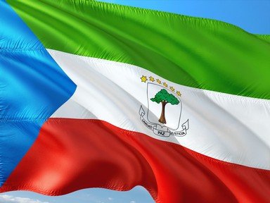
5. As is often the case, the colours on the national flag of Equatorial Guinea were chosen to represent concepts that the government of the time considered important. The Equatoguinean flag is blue, green, white and red (with gold and brown also appearing in the coat of arms at the centre of the flag). Which of these colors was chosen to stand for peace? Hint


Question 6 of 10
6. This map shows most of mainland Equatorial Guinea to be part of the Atlantic Equatorial coastal forest zone, apart from a small area on the coast near the mouth of the Muni River. What kind of ecosystem is found in this region? Hint


Question 7 of 10
7. The only volcano in Equatorial Guinea which was active in historical times is located on Bioko Island. The Portuguese explorers called it Pico de Santa Isabel; what is this peak's contemporary name? Hint


Question 8 of 10
8. Speaking of Bioko, it is the main site for the exploitation of one of Equatorial Guinea's most significant natural resources. Which of these is it? Hint


Question 9 of 10
9. As is the case for many African countries, Equatorial Guinea is inhabited by the members of a number of different tribal groups, as well as descendants of European colonists. Which of these was the dominant ethnicity of Equatoguineans at the start of the 21st century? (Read the fine print.) Hint


Question 10 of 10
10. In 2011 the government of Equatorial Guinea announced the plan to build a new capital, tentatively named Djibloho. It was stated that the new capital would be located "between Bata and Mongomo". What was somewhat puzzling about this announcement? Hint


(Optional) Create a Free FunTrivia ID to save the points you are about to earn:

arrow Select a User ID:
arrow Choose a Password:
arrow Your Email:


View Image Attributions for This Quiz

Most Recent Scores
Nov 06 2024 : Johnmcmanners: 10/10
Nov 02 2024 : calmdecember: 9/10
Oct 30 2024 : twlmy: 10/10
Oct 26 2024 : hosertodd: 9/10
Oct 11 2024 : leith90: 10/10
Sep 30 2024 : Jooga1: 8/10
Sep 29 2024 : infinite_jest: 10/10
Sep 26 2024 : parrotman2006: 6/10

Score Distribution

quiz
Quiz Answer Key and Fun Facts
1. Equatorial Guinea is located on the west coast of Africa, as this map shows. What is the name for the body of water on which the mainland part of the country has its coastline?

Answer: Gulf of Guinea

The Gulf of Guinea is the part of the Atlantic Ocean that forms the big indentation in the west coast of the African continent. Guinea was used by European explorers to refer to the land in the entire region surrounding the gulf, with each region prefixed by the name of the colonial power laying claim to its control, and it is still included in the names of three contemporary countries - Equatorial Guinea, Guinea, and Guinea-Bissau.

As its name suggests, the equator passes through Equatorial Guinea, but only when you include its island territories.

The mainland part of the country is all located north of the equator.
2. Which of the following lists the two land neighbours of Equatorial Guinea?

Answer: Cameroon and Gabon

Cameroon, whose name derives from the name given to one of its main rivers by Portuguese explores, Rio dos Camaroes (Portuguese for River of Shrimp), is adjacent to the north of Equatorial Guinea. During colonial times, it was first a German colony, then was split between the French and the English after World War I. Gabon, formerly part of French Equatorial Africa, forms the eastern and southern borders of Equatorial Guinea. Equatorial Guinea was previously known as Spanish Guinea, and that heritage is reflected in the fact that Spanish is the official language of government. French is also listed by the government as an official language, and they note that most people also speak one of the Bantu languages for everyday use.
3. The Equatoguinean coat of arms features six stars. What do they represent?

Answer: The six major land areas that make up the country

Equatorial Guinea is made up of the mainland, usually referred to as Rio Muni, or Mbini in the local Fang language, and five major offshore islands. Bioko, where the capital city of Malabo is located, is the northernmost island, and lies much closer to Cameroon than to the continental part of Equatorial Guinea. The southernmost, Annobon, is the only part of the country that lies south of the equator, and is even further away from the mainland than is Bioko; in fact, its closest neighbour is the archipelagic nation of Sao Tome and Principe. The other three islands, Corisco, Elobey Grande and Elobey Cisco, are much smaller and lie close to the mainland's coast, although still to its south.

There are, according to the government, two official languages in Equatorial Guinea - Spanish and French. Some other sites include Portuguese as an official language, and there are also many different tribal languages spoken, mostly one of the Bantu family of languages.

Ethnic groups of a significant size in Equatorial Guinea include Bubi, Fang, Ndowe, Batanga, Benga, Combe, Belengue, Bujeba and Baseke, as well as some Europeans.

Approximately 93% of the population consider themselves Christian, mostly Roman Catholic. About 5% adhere to native animistic beliefs, and the rest are spread in small numbers across Islam, Baha'i, and other faiths.
4. Looking at the coat of arms again, you will see a tree depicted on the grey shield in its centre. What kind of Equatoguinean tree is this?

Answer: Silk cotton tree

While you may never have heard of the silk cotton tree, the image doesn't look much like any of the other more familiar trees. The name refers to a tropical tree in the mallow family, botanically known as belonging to the genus Bombax, and native to the region of Equatorial Guinea and its neighbours.

It was under a silk cotton tree that the first treaty between Spanish settlers and a native leader was signed, following the ceding of the region to the Spanish by the Portuguese in the Treaty of El Pardo (1788).
5. As is often the case, the colours on the national flag of Equatorial Guinea were chosen to represent concepts that the government of the time considered important. The Equatoguinean flag is blue, green, white and red (with gold and brown also appearing in the coat of arms at the centre of the flag). Which of these colors was chosen to stand for peace?

Answer: White

The blue triangle at the hoist side stands for the waters of the Gulf of Guinea, where the important island regions of the country are located; the green stripe at the top stands for the jungle and natural resources; the red stripe at the bottom stands for the blood shed in the struggle for independence, and the white stripe in the centre stands for peace, joining the other three symbols harmoniously.

It is interesting to note that Equatorial Guinea and neighbouring Gabon are two of the very few sub-Saharan countries that do not use the Pan African colours - red, green and gold or red, green and black.
6. This map shows most of mainland Equatorial Guinea to be part of the Atlantic Equatorial coastal forest zone, apart from a small area on the coast near the mouth of the Muni River. What kind of ecosystem is found in this region?

Answer: Mangrove

Most of the significant mangrove area of western Africa is in Nigeria, but there are patches along the western coast, including the Muni estuary, on the southern Equatoguinean coast near the border with Gabon. Like other mangrove areas, these are full of many species of sealife, from oysters and crabs through fish and turtles to manatees and monkeys, not to mention the avifauna, many of which breed in the mangroves, and more who use it as a convenient resting point during migration.

The entire country of Equatorial Guinea has a tropical climate, and is generally hot and humid year-round.
7. The only volcano in Equatorial Guinea which was active in historical times is located on Bioko Island. The Portuguese explorers called it Pico de Santa Isabel; what is this peak's contemporary name?

Answer: Pico Basile

Although you will still see the peak referred to as Santa Isabel, its name is now officially Pico Basile. It is one of the three volcanoes that compose the island of Bioko, the other two (San Carlos and San Joaquin) being extinct. Bioko was once the end of a peninsula extending into the ocean from Cameroon, before being cut off to form an island, and its volcanoes are part of what is called the Cameroon Line, a chain of volcanoes which also extends through nearby Sao Tome and Principe. Quioveo is found on the island of Annabon, the southernmost part of Equatorial Guinea.

The Portuguese explorer Fernão do Pó named the island Formosa Flora (Beautiful Flower) in 1472, but in 1494 it was renamed Fernando Pó in honor of its discoverer. This was probably somewhat confusing, since the islands of Sao Tome and Principe were also called Fernando Pó until the 20th century! It is currently officially called Bioko, but the natives call it Otcho in their Bubu language.
8. Speaking of Bioko, it is the main site for the exploitation of one of Equatorial Guinea's most significant natural resources. Which of these is it?

Answer: Petroleum and natural gas

In 1996 large reserves of oil and natural gas were found in Equatoguinean waters in the Gulf of Guinea. There are three major processing plants on Bioko, which deliver their products to Malabo, from where they are shipped to their international destinations.

The income from this trade has led to a dramatic increase in the nation's wealth, but most of it has remained in the hands of a few. The majority of the population is engaged in subsistence farming and fishing, with the other industries mentioned in the country offering employment for some.
9. As is the case for many African countries, Equatorial Guinea is inhabited by the members of a number of different tribal groups, as well as descendants of European colonists. Which of these was the dominant ethnicity of Equatoguineans at the start of the 21st century? (Read the fine print.)

Answer: Fang

The Fang, a member of the Bantu family, are indigenous on the mainland of Equatorial Guinea, and comprised about 80% of the population in 2003. About 15% of the population, mostly on the island of Bioko where they are indigenous, were Bubi, another Bantu tribe.

A mixture of other tribes made up roughly 5%, and there were handfuls of other groups, mostly immigrants from other African nations. Most of the Portuguese left when Spain took control, and most of the Spaniards left when Equatorial Guinea achieved independence in 1968.
10. In 2011 the government of Equatorial Guinea announced the plan to build a new capital, tentatively named Djibloho. It was stated that the new capital would be located "between Bata and Mongomo". What was somewhat puzzling about this announcement?

Answer: Bata and Mongomo are located on opposite sides of the country

Bata is on the northwest coast, while Mongomo is almost exactly due east, on the eastern border! The official announcement does state that the new city, being built to fulfill the president's dream, will be located in the province of Wele-Nzas, of which Mongomo is the capital, so one assumes Djibloho will be somewhat closer to Mongomo than Bata.

The new capital is being planned for 160,000 residents, and will have lots of environmentally-sustainable features, according to the announcement. It is also planned to take full advantage of the local jungle environment, and the Wele River on which it will be located.

The plans look beautiful - let's hope the reality manages to match them!
Source: Author looney_tunes

This quiz was reviewed by FunTrivia editor Pagiedamon before going online.
Any errors found in FunTrivia content are routinely corrected through our feedback system.
Related Quizzes
This quiz is part of series Written for the Bus Ride:

You think you can write just one, but it turns out that writing quizzes suitable for being visited by the tourists on the Bus Ride is addictive - there's just so much to find out!

  1. Saint Vincent and the Grenadines Average
  2. Barbados, Land of the Flying Fish Average
  3. Calypso Country - Trinidad and Tobago Average
  4. "The Land, the People, the Light" - Saint Lucia Average
  5. A Provincial Tour of Zimbabwe Average
  6. Republic of Benin, Formerly Dahomey Average
  7. The Landlocked Kingdom of Lesotho Average
  8. Honduras: "Free, Sovereign and Independent" Average
  9. Exploring Kosovo Average
  10. Democratic Republic of Sao Tome and Principe Average
  11. "We Stand With God" in Vanuatu Average
  12. They Came to Baghdad Average

11/24/2024, Copyright 2024 FunTrivia, Inc. - Report an Error / Contact Us