FREE! Click here to Join FunTrivia. Thousands of games, quizzes, and lots more!
Quiz about The Shipping Forecast

The Shipping Forecast Trivia Quiz


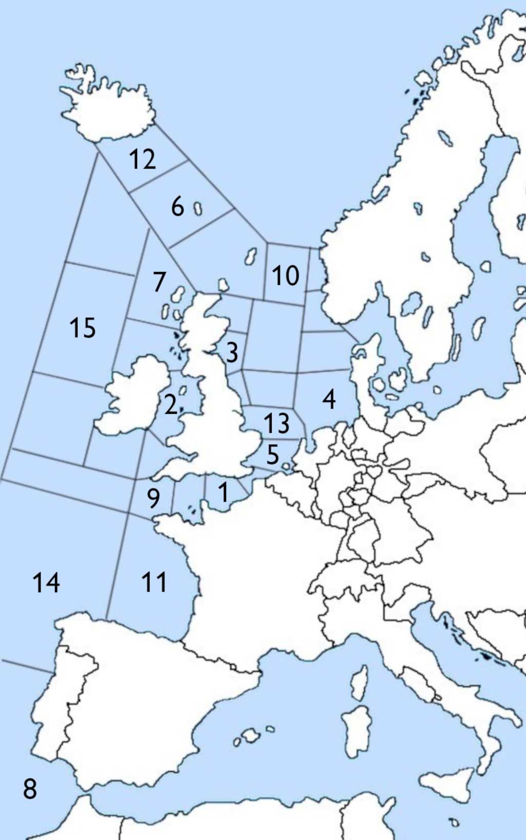
Vital to mariners and beloved by insomniacs and early risers, the "Shipping Forecast" has made many names of sea areas known to the British public. You may know the names but can you match them to the correct locations?

A label quiz by Snowman. Estimated time: 3 mins.
  1. Home
  2. »
  3. Quizzes
  4. »
  5. Geography Trivia
  6. »
  7. United Kingdom
  8. »
  9. UK Bodies of Water

Author
Snowman
Time
3 mins
Type
Label Quiz
Quiz #
417,227
Updated
Nov 19 24
# Qns
15
Difficulty
Easy
Avg Score
13 / 15
Plays
136
Awards
Top 5% quiz!
Last 3 plays: Mike2055 (6/15), Stoaty (15/15), Duckay (3/15).
Click on image to zoom
Hebrides Thames Biscay Wight Plymouth Humber Trafalgar Faroes German Bight Viking Irish Sea FitzRoy Forth South-East Iceland Rockall
* Drag / drop or click on the choices above to move them to the answer list.
1. Named for an island in the English Channel  
2. Named for the body of water that it covers  
3. Named for an estuary, or firth, of several rivers  
4. Named for a coastal bend across three nations  
5. Named for an estuary of a river where it flows from the capital to meet the North Sea  
6. Named for an autonomous territory of Denmark  
7. Named for the islands contained within it  
8. Named for the cape that it borders  
9. Named for a port city  
10. Named for underwater hills in the North Sea  
11. Named for the gulf or bay that it covers  
12. Named for the area of country that it borders  
13. Named for the tidal estuary that shares its name with a famous bridge  
14. Named for the originator of the first shipping forecasts  
15. Named for an uninhabited rock  

Most Recent Scores
Dec 19 2024 : Mike2055: 6/15
Dec 17 2024 : Stoaty: 15/15
Dec 16 2024 : Duckay: 3/15
Dec 10 2024 : workisboring: 3/15
Nov 28 2024 : Thbigbopper: 13/15
Nov 25 2024 : FREEDOM49: 15/15
Nov 21 2024 : AmandaM: 15/15
Nov 20 2024 : parrotman2006: 13/15
Nov 20 2024 : briandoc5: 13/15

Quiz Answer Key and Fun Facts
1. Wight

The island is of course the Isle of Wight, former summer home of Queen Victoria and popular tourist destination to this day. Separated from mainland UK by the Solent, it is just three kilometres from the mainland at its nearest point. The island was separated from the mainland at the same time as Great Britain became an island, when the English channel and the Solent flooded at the end of the last ice age, approximately 7000-8000 BCE.
2. Irish Sea

The Irish Sea, which stretches from St George's Channel in the south to North Channel in the north, borders all four of the countries of the United Kingdom as well as Ireland. It is believed that it was formed around 8,000 BCE at the end of the last ice age when what was an inland lake rose and joined to water from the Atlantic Ocean.

The environmental activism charity Greenpeace described the Irish Sea as the most radioactive in the world thanks to the presence on its shores of one of the UK's nuclear power plants, Sellafield, which had been discharging nuclear waste into the sea since the 1960s.
3. Forth

The shipping zone is named for the Firth of Forth, which in turn takes its name from the River Forth, one of several rivers that meet the North Sea between Fife to the north and Lothian to the south.

The firth is perhaps as well known for the bridges that cross it as for the waters below. One bridge, the Forth Bridge (not to be confused with the Forth Road Bridge alongside it), was granted UNESCO World Heritage Site status in 2015 and famously gives its name to an expression for a never-ending task, "painting the Forth Bridge", based on an apocryphal story that the painting of the bridge takes so long that as soon as it is finished, it is time to start the job again from the other end.
4. German Bight

A bight is a concave bend in a body of water. German Bight covers the bend from The Netherlands along the German coast up to the Jutland peninsula and Denmark. All along its coast lies the Wadden Sea, a UNESCO World Heritage Site whose mudflats and salt flats are host to a wide variety of birds, fish and marine mammals.

When the map of the "Shipping Forecast" areas was drawn in 1949, the area was known as Heligoland after the island situated in the south-east of the area. The German Bight name was adopted in 1956.
5. Thames

The River Thames is best known as the river than runs through the centre of London but it runs for over 200km from Gloucestershire in the west, through Oxford, where it is known as the Isis, to the North Sea between the counties of Kent and Essex in the east. Exactly where the river ends and the sea begins is open to debate but it is marked by stones at Westcliff-on-Sea on the northern shore and the Isle of Grain (not actually an island) on the southern shore.

The line that is notionally drawn between the two stones is known as the Yantlet line.
6. Faroes

The Faroe Islands are almost equidistant between Norway, Iceland and the United Kingdom but are in fact an autonomous part of Denmark. Ownership of the territory has changed hands multiple times over the centuries but passed to Denmark with the 1814 Treaty of Kiel.

This treaty brought peace during the Napoleonic wars between the French-supporting Denmark and Norway and the anti-French UK and Sweden. A lot of land changed hands with this treaty with Heligoland passing from Denmark to the UK, Norway entering a union with Sweden and the Faroes passing from Norway to Denmark along with Greenland and Iceland.
7. Hebrides

The Hebrides consist of more than 50 inhabited and ten uninhabited islands collected into two groups known as the Inner Hebrides and the Outer Hebrides. In the 2022 census, the number of occupants of the islands ranged from the Inner Hebredian Skye with a population of more than 10,000 and Lewis in the Outer Hebrides with close to 20,000 inhabitants down to islands such as Flodaigh and Soay, which had populations in single figures.
8. Trafalgar

The "Shipping Forecast" is broadcast twice a day on the BBC but Trafalgar is unique, as the most distant sea area from the British mainland, for normally only being included in the first of the two daily broadcasts at 0048, UK time. If there is particularly poor weather in the region then it will also be included in the 0520 forecast but it is otherwise excluded.

The name Trafalgar is most closely associated with the battle that took place in its waters during the Napoleonic wars in 1805. The combined forces of the French and Spanish fleets had set sail to try and seize control of the English Channel, thereby providing protection for the planned invasion of the UK by Napoleon's Grand Armee. Their ships were met by the UK fleet under the command of Admiral Horatio Nelson, just off Cape Trafalgar in south-western Spain. Despite being outnumbered, Nelson led the British ships to a decisive victory, with more than half of the French and Spanish ships either captured or destroyed. Sadly for Nelson he would not live to see the moment of victory as he was cut down by a musketeer's bullet as he stood on the deck of HMS Victory.
9. Plymouth

Situated on its south coast, Plymouth is the largest city in the English county of Devon. The city has a strong maritime heritage as the embarkation port for both the Pilgrims' journey to the New World and for the English fleet that defeated the Spanish Armada in 1588 under the command of Sir Francis Drake.

Less celebratory but equally notable was the role that Plymouth played in the establishment of the Atlantic slave trade. Local trader John Hawkins pioneered the English involvement when he ventured to Sierra Leone in 1562 as a privateer and two years later to Guinea, sponsored by the English crown. He traded his kidnapped men in the Caribbean for sugar, pearls and other valuable commodities including tobacco, which he introduced to the English court, long before the more celebrated Walter Raleigh did the same.
10. Viking

The Viking-Bergen banks are underwater hills that can be found between the Shetlands Islands and Norway. Until sea levels rose towards the end of the last ice age, the hills probably rose above the surface of the sea as an island. It is also possible, if sea levels around 10,000 BCE were as low as the most extreme projection, that the hills formed part of the area of land known as Doggerland, which connected eastern Britain to Scandinavia and the European mainland.
11. Biscay

The Bay of Biscay sits between the northern coast of Spain and the west coast of France. It takes its English name from the province of Biscay in Spain. It is also part of the autonomous Basque Country and contains its largest city, Bilbao.

The bay is notorious for its weather, with some of the most violent storms in the Atlantic and very high waves caused in part by the steep change in depth at the edge of the continental shelf several miles off the coast of the bay. As such, some cities on the bay such as Biarritz are very popular with the surfing community.
12. South-East Iceland

The shipping area was originally just called Iceland but was renamed in 1956 to give a more accurate description of its location. Formerly a part of Denmark after the 1814 Treaty of Kiel, Iceland became an independent nation in 1944.

The south-east of Iceland is a sparsely populated region of the country with its largest town, Hofn having a population of fewer than 3000 people. The region is dominated by Europe's largest sub-Arctic glacier, Vatnajokull. The glacier covers approximately ten percent of the country and is nearly a kilometre thick in places. It conceals a number of active volcanoes whose eruptions have caused a number of giant fissures in the glacier and have helped to create a lake of water so vast that it contains 200 times the annual water flow of Iceland's largest river by volume, the Olfusa.
13. Humber

The Humber is the largest coastal plain on the UK's east coast. Formed by the confluence of the River Ouse and the River Trent it separates Lincolnshire from Yorkshire's East Riding. It is 14 km wide at its widest point and has a catchment area that covers one fifth of the land area of England. It is macrotidal, meaning its tide is greater than four metres, reaching a peak average of 7.4m at Salt End approximately 30km inland. It is crossed near Kingston upon Hull by the Humber Bridge which, when it opened in 1981, was the longest single-span suspension bridge in the world.

The coastal plain was formed when the Humber valley was flooded by melting glaciers at the end of the last ice age but instead of the valley being eroded, it was inundated with deposits of clay and silt, flattening the landscape. Its mudflats and salt marshes make it the perfect habitat for over-wintering birds, with up to 130,000 birds using the estuary each year.
14. FitzRoy

In the original forecast, the area was known as Finisterre, named after the peninsula in Galicia, northern Spain. However, as both the French and Spanish forecasts used the same name for a different, smaller area, it was decided in 2002 to change the name to avoid confusion.

Robert FitzRoy was an aristocrat whose ancestry traced back to King Charles II of England and whose uncle was the Duke of Grafton. Through his family contacts he was given a place on the crew of HMS Beagle's first voyage where he helped survey the coastal waters around Tierra del Fuego. During the trip he was appointed captain at the age of just 23, retaining the position for the famous second voyage that included as a passenger, Charles Darwin, whose experiences on the trip led him to develop his theory of evolution by natural selection.

After his naval career had ended, FitzRoy turned to politics, becoming an MP and then being appointed Governor of New Zealand. After his return to the UK, he was given a role in the newly formed meteorological department of the Board of Trade, which would eventually become the Met Office. He was tasked with gathering maritime weather data and used this data to start issuing what he described as "weather forecasts", the first known use of the term. These were first published in print in 1861 and led to the use of weather cones in ports to warn ships of gale force conditions. Fifty years later, the Met Office began using radio transmissions to disseminate this information on a daily basis and in 1925 the "Shipping Forecast" was first broadcast on the BBC.
15. Rockall

With a height of 17 metres and a land area of 25 by 31 metres, Rockall is a small islet in the Atlantic Ocean that can disappear completely under the waves in storm conditions. Lying approximately 300km from its nearest Scottish island and 423km from the nearest Irish island, the ownership of the uninhabitable rock was claimed by the UK in 1955 and was formally annexed to the UK in 1972, but this claim was not recognised by Ireland. De-classified documents revealed that the UK's claim was based on the fear that the rock could be claimed by a hostile nation and used to spy on the British missile program in the Outer Hebrides.

Its surrounding sea area is also disputed for fishing rights with the UK and Ireland agreeing to share the waters but Iceland and Denmark disputing this agreement.
Source: Author Snowman

This quiz was reviewed by FunTrivia editor agony before going online.
Any errors found in FunTrivia content are routinely corrected through our feedback system.
Related Quizzes
1. Sail On, Silver Girl Easier
2. What's the British River? Easier
3. River Severn Average
4. British Rivers Average
5. River Lea Average
6. River Songs Average
7. Rivers of Britain Average
8. Flow North Young Stream Average
9. A Journey along the River Wye Tough
10. Lakes and Reservoirs of the UK Average
11. The English Channel Average
12. A River Runs Through It Average

12/21/2024, Copyright 2024 FunTrivia, Inc. - Report an Error / Contact Us