FREE! Click here to Join FunTrivia. Thousands of games, quizzes, and lots more!
When You're Down Trivia Quiz
You might be in one of these canyons
Can you place each of these canyons or gorges, whose names may be very familiar, in its proper location on this world map that is centered on the Pacific, rather than the Atlantic, Ocean?
A label quiz
by looney_tunes.
Estimated time: 3 mins.
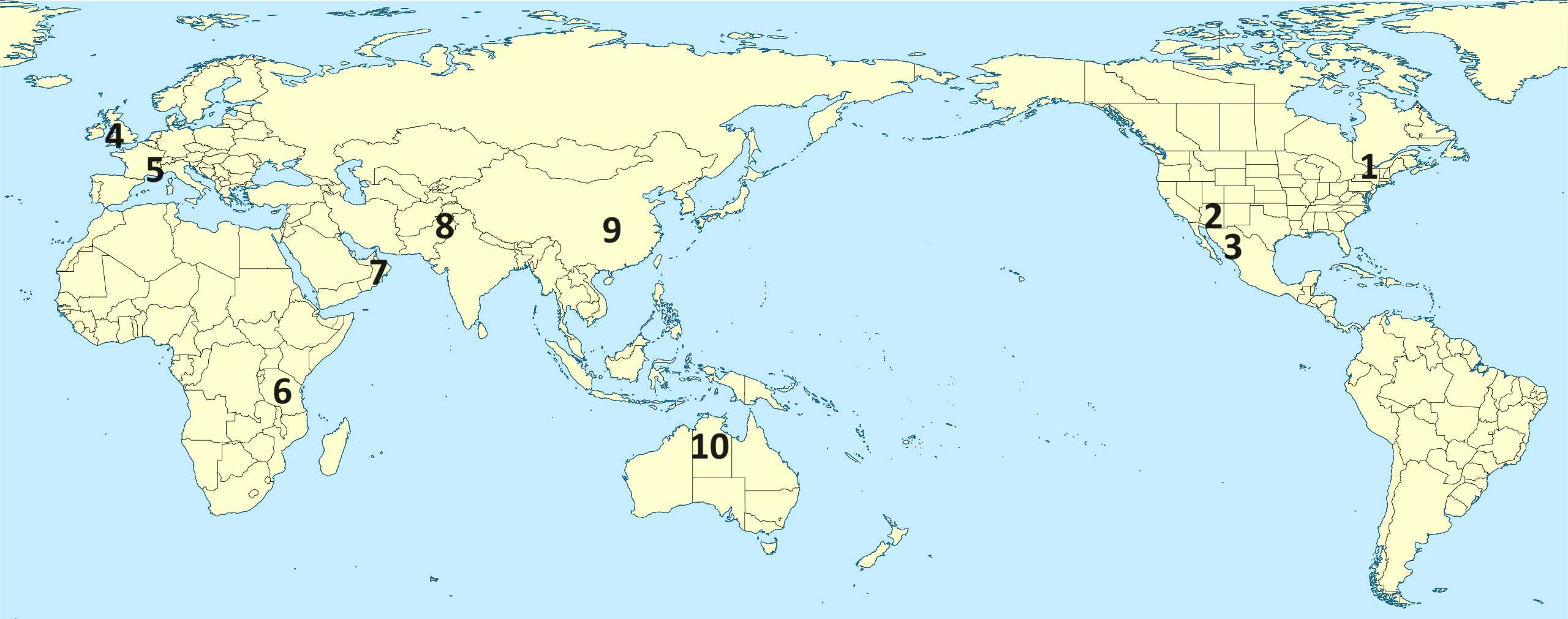
Niagara GorgeGrand CanyonIndus River GorgeCopper CanyonCheddar GorgeThree GorgesNitmiluk GorgeWadi GhulVerdon GorgeOlduvai Gorge* Drag / drop or click on the choices above to move them to the answer list.
1.
2.
3.
4.
5.
6.
7.
8.
9.
10.
Most Recent Scores
Today
:
Maybeline5: 2/10
Dec 19 2024
:
Guest 109: 3/10
Dec 12 2024
:
Guest 170: 8/10
Dec 12 2024
:
Guest 81: 7/10
Dec 05 2024
:
Guest 94: 4/10
Nov 28 2024
:
tiye: 10/10
Nov 26 2024
:
superhooppete: 8/10
Nov 24 2024
:
lg549: 10/10
Nov 20 2024
:
Guest 118: 10/10
Quiz Answer Key and Fun Facts
1. Niagara Gorge
Lying on the border of the USA and Canada, Niagara Gorge has been carved out of the surrounding rocks by the action of the Niagara River downstream from the famous Niagara Falls, honeymoon destination of the universe. Or stimulus to attack, if you're one of the Three Stooges.
About 12,000 years ago the falls were located near Queenston, Ontario, which is where the gorge now terminates. Over the years, the water has eroded the underlying rock at the point where the river hits the fall, causing it to recede slowly so that the waterfalls are steadily moving upstream. The energy of the falling water then erodes the softer surface rocks at the base of the falls, causing the river to move lower and creating a gorge through which it flows for about 10 km.
The water of the river flowing through the gorge is highly turbulent, so individuals are generally prohibited from boating through the gorge, although some exceptions have been made for experts. Swimming in the rapids is also a really bad idea - in 1933 Matthew Webb, the first person to swim the English Channel, died attempting to swim their length.
2. Grand Canyon
The Grand Canyon, in the American state of Arizona, is one of the most famous and spectacular canyons of the world. The Colorado River has eroded the canyon (or more accurately, according to current thought, the series of canyons that have been brought together into one large hole over the eons), exposing layers of rock that provide valuable evidence of the geologic history of the region for nearly two billion years. It is not the deepest canyon in the world, but it is over a mile deep, because the river action has combined with geologic uplift of the underlying rock to increase the erosion rate.
Native Americans have inhabited the canyon and its caves since (probably) around 1000 BCE. It is a holy site for the Pueblo people who have descended from the earliest inhabitants. Other groups have settled in the area at various times, including the Cohonina to the west and the Sinaqua to the southeast. The first European known to have visited the Grand Canyon was the Spaniard García López de Cárdenas, sent by Francisco Vázquez de Coronado to look for the Seven Cities of Cibola in 1540. They were unable to descend to the canyon floor, so went on their way.
3. Copper Canyon
Copper Canyon is actually six canyons formed by six rivers that converge to form the Rio Fuerte in the Mexican state of Chihuahua. Their walls are green, the colour of oxidized copper, hence the name. The complex is much larger than the Grand Canyon, but less accessible, so most tourists visit by way of a spectacular scenic train ride.
The local people, the Tarahumara or Rarámuri, live in the more remote reaches of the canyon, to maintain their independence. When Spanish settlers arrived in the 17th century and discovered gold (and copper and silver) in the area, they forced many of the inhabitants into virtual slavery in the mines, so there is an understandable reluctance to participate in the conquering society.
Those who live in the canyon often are mobile, residing in the mountains (where it is cooler) during the summer, and moving to the lower parts of the canyon for the winter, where it is sheltered from the harshest impact of the weather. Some communities have formed near the rail line, establishing facilities to accommodate tourists who want to stop and visit; this is a controversial issue in the 21st century.
4. Cheddar Gorge
Cheddar Gorge, near the town of Cheddar in Somerset, England, is probably most readily recognised because of the cheese produced in the area, and traditionally aged in caves along the walls of the gorge (possibly since prehistoric times, although the cheddar cheese of modern times was developed in the 19th century).
Of perhaps equal significance is the fact that Britain's oldest (nearly) complete human skeleton, estimated to be around 9,000 years old, was found there in 1903, and named Cheddar Man. Analysis of the DNA of this skeleton, touted by the media at the time this was done as "the first Englishman", showed that his genotype was similar to other Western Europeans of the time; his phenotype (appearance) was suggested to be dark brown hair, blue-green eyes and dark-to-black skin.
Cheddar Gorge has become quite a tourist destination, whether it is to see the stalactites and stalagmites of the caves that are open for tourists, to climb the cliffs, to visit the Cheddar Man museum, or to spot the local flora and fauna.
5. Verdon Gorge
The River Verdon, flowing through the Provence-Alpes-Côte d'Azur in the extreme southeastern part of France, has a blue-green colour due to its glacial origins, which is the source of its name. The glacial water contains fine particles of rock, called glacial flour, caused by the abrasion of underlying rock that gets carried from the glacier in its runoff. The gorge is about 700m deep, and its limestone walls are popular with rock climbers. Fishers prefer the river, which also offers opportunities for canoeing and rafting. Hikers, of course, find paths to follow in numerous parts of the gorge.
The gorge is situated near the communes of Castellane and Moustiers-Sainte-Marie, and its downstream end is located at the entrance to Lake Saint-Croix, one of five artificial lakes created by damming the Verdon. Before that, the village of des Salles-sur-Verdon was on the edge of the river downstream of the gorge.
6. Olduvai Gorge
Unlike most of the canyons in this quiz, Tanzania's Olduvai Gorge is not primarily known for its spectacular scenery. Rather, it is known as an important archeological site, where some of the earliest human fossils have been found. There is evidence of Homo habilis, currently considered the first 'true human' to have appeared, living in the area from about 1.9 million years ago.
The gorge is actually two connecting ravines cut into the edge of the Great Rift Valley. Their steep sides mean that many layers of rock have been revealed (and carefully sequenced since research in the area first began just before World War I). The area was once a fertile lakebed, so attracted a number of waves of settlers. Their fossilized remains, along with trace evidence of their lifestyles, have provided a feast for paleoanthropologists. The Olduvai Gorge Museum, established by Mary Leakey in the 1970s, provides visitors insight into their findings.
7. Wadi Ghul
"The Grand Canyon of Arabia" is located in northeast Oman, near that country's highest mountain, Jebel Shams (whose name means Mountain of Sun). Its peak is the first Omani site at which one can see the sunrise, due to its height. However, since it is a military base, there is no public access.
Wadi Ghul is about an hour's drive from Nizwa (the capital of Oman before it was moved to Muscat), but if you want to drive into the actual canyon you need a four-wheel drive vehicle. While you are in the vicinity, you might also enjoy exploring some of the region's caves, which include Al Hoota Cave, home of the Omani blind cave fish.
8. Indus River Gorge
The Indus River runs through the Himalayas starting in Tibet, flowing northwest through Kashmir then southwest through the Punjab region and across Pakistan before reaching the Arabian Sea near Karachi. The Indus Gorge is located just past the northernmost point, near Nanga Parbat, the ninth-highest mountain on the planet. The gorge is around 5,000 m (3 miles) deep - making it one of the deepest canyons on the planet.
While you are in the vicinity, you might like to consider driving along one of the world's most dangerous roads (according to a number of such lists posted for drivers keen to push their four-wheel drive vehicles to display what they've got) to reach Fairy Meadows, where treks to the top of Nanga Prabat start. You will need to finish the trip on foot or bicycle, leaving the vehicle to collect on the return journey.
9. Three Gorges
The Three Gorges of the Yangtze stretch for 300 miles from the municipality of Chongqing east to the city of Yichang. The gorges are named (in order) the Qutang, the Wu, and the Xiling.
The entrance to the Qutang Gorge, which is called the Kuimen Gate, has a white cliff on its southern bank called the Chalk Wall, which is inscribed with around 1000 characters, some dating from the 10th century. Qutang is the shortest and narrowest (and generally considered the most spectacular) of the three.
The Wu Gorge is also called the Great Gorge. It passes through the Wu Mountains, which feature Twelve Peaks, including Goddess Peak, said to be the incarnation of the weather goddess Yaoji.
The Xiling Gorge is the largest of the three, almost as long as the other two combined. It was in this part of the river that the Three Gorges Dam was constructed.
The region came to the world's attention with the controversial construction of the Three Gorges Dam, the world's largest hydroelectricity project, at the start of the 21st century. As well as generating electricity, the dam is intended to be used to control the water flow and reduce or prevent the historically disastrous flooding of the Yangtze. Construction of the dam led, among other things, to the flooding of a number of important archaeological sites, as well as requiring the relocation of a number of settlements. The higher water level in the gorges means that the sides no longer reach quite so far above the heads of those traversing them by boat; since the river is also wider, the waters are more easily navigated.
10. Nitmiluk Gorge
Nitmiluk Gorge is actually a series of 13 gorges on the Katherine River, from which it previously took its name. This is a site with deep spiritual significance for the Jawoyn people who live in the area, as indicated by its name, which translates into English as "place of the cicada dreaming". The term dreaming indicates that it is a centre for their stories of the creation of the world, and the continuing interaction of the driving spiritual forces with humans. The Jawoyn legends include one in which Nabilil the crocodile (who carved out the landscape of the area) sets himself in place at the entrance to one of the gorges, and makes a noise like that of a cicada.
The gorges are located in Nitmiluk National Park, about 250 km south of Darwin, and 25 km north of the city of Katherine. During the dry season (theoretically, November through May) the water is relatively placid, but care needs to be taken because freshwater crocodiles nest along the banks. They are said to pose no danger to people, but during the wet season saltwater crocodiles make their way upriver, and they are a definite danger, and boating and swimming are banned during the wet. Authorities try to remove them at the start of the dry season, so that swimming will be safe in the dry, but I personally would avoid the whole issue!
This quiz was reviewed by FunTrivia editor agony before going online.
Any errors found in FunTrivia content are routinely corrected through our feedback system.