FREE! Click here to Join FunTrivia. Thousands of games, quizzes, and lots more!
Quiz about A Greater Whiter North

A Greater, Whiter North Trivia Quiz


Take a trip north of sixty to discover some of the beautiful, but oft-frigid cities and regions of the northern territories of Canada. Pack something warm, eh!

A photo quiz by kyleisalive. Estimated time: 4 mins.
  1. Home
  2. »
  3. Quizzes
  4. »
  5. Geography Trivia
  6. »
  7. Canada
  8. »
  9. Canada - Territories

Author
kyleisalive
Time
4 mins
Type
Photo Quiz
Quiz #
345,335
Updated
Dec 03 21
# Qns
10
Difficulty
Average
Avg Score
6 / 10
Plays
4221
Awards
Top 5% quiz!
Last 3 plays: impdtwnaa (7/10), 1ziggy (4/10), Debarrio (4/10).
-
Question 1 of 10
1. One of the most-populated towns in the Canadian territories, this location is the capital of the Northwest Territories. What is its name? Hint


photo quiz
Question 2 of 10
2. The only way to get to this isolated Northwest Territories city is by flying to Mike Zubko Airport or by taking the Dempster Highway (Hwy 8) from the Yukon (passing through Fort McPherson). What is its name? Hint


photo quiz
Question 3 of 10
3. Situated on the southern edge of Great Slave Lake, what NWT community is upstream from Alexandra Falls? Hint


photo quiz
Question 4 of 10
4. This image depicts Miles Canyon and a river running near Yukon's capital city. What city would that be?

Answer: (One Word)
photo quiz
Question 5 of 10
5. From the Midnight Dome you can overlook Dawson Creek, British Columbia, the only provincial location north of sixty degrees latitude (north).


photo quiz
Question 6 of 10
6. These inukshuks stand in a town in the Foxe Basin in a rather northern reach of Nunavut. They can be found in what location named (partially) after a northern structure? Hint


photo quiz
Question 7 of 10
7. Which of these territorial capitals, named as such in 1999, is on Baffin Island? Hint


photo quiz
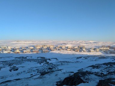
Question 8 of 10
8. This arch in Nunavut is found directly on the Arctic Circle and it's found in a town with the same name as a division of Hong Kong. What is the town's name? Hint


photo quiz
Question 9 of 10
9. Archimedes never visited this small weather outpost on Ellesmere Island, but he'd be proud of the name. What is the name of this Nunavut settlement with a typical population of less than ten temporary residents?

Answer: (One Word)
photo quiz
Question 10 of 10
10. Alert, in Nunavut, is closer to the North Pole than any paved road.


photo quiz

(Optional) Create a Free FunTrivia ID to save the points you are about to earn:

arrow Select a User ID:
arrow Choose a Password:
arrow Your Email:


View Image Attributions for This Quiz

Most Recent Scores
Today : impdtwnaa: 7/10
Jan 20 2025 : 1ziggy: 4/10
Jan 20 2025 : Debarrio: 4/10
Jan 17 2025 : Trivia_Fan54: 10/10
Jan 17 2025 : Emma058: 9/10
Jan 16 2025 : Guest 72: 9/10
Jan 16 2025 : Mugaboo: 8/10
Jan 16 2025 : SixShutouts66: 6/10
Jan 16 2025 : Guest 170: 3/10

Score Distribution

quiz
Quiz Answer Key and Fun Facts
1. One of the most-populated towns in the Canadian territories, this location is the capital of the Northwest Territories. What is its name?

Answer: Yellowknife

Yellowknife was established in the days of the Klondike, but was hundreds of miles away. Why did people visit? Many years later, it turned out that the nearby Yellowknife River was actually another spot at which gold could be panned. What odds, eh?
Until the 1990s, Yellowknife was the smallest of the Canadian capital cities, but with the closing of the gold mines and the separation of the Northwest Territories and Nunavut, a new capital to the northeast was established (in 1999). To replace gold mining, diamonds were located in the lands surrounding the city becoming the top industry in the area.
Yellowknife is on the shores of Great Slave Lake, one of the largest in the world.
2. The only way to get to this isolated Northwest Territories city is by flying to Mike Zubko Airport or by taking the Dempster Highway (Hwy 8) from the Yukon (passing through Fort McPherson). What is its name?

Answer: Inuvik

Inuvik is one of the northwestern-most spots in the Northwest Territories. Situated on the MacKenzie River, it was established in the 1960s in order to access Aklavik, a previously-established location to the west threatened by unsafe weather and geological conditions. One of the northernmost communities in all of the territory, it's in part of the country that receives more than a month of midnight sun, and another month of constant night.

There is also an igloo-shaped church (one of the northernmost on the continent) known as Our Lady of Victory. It's difficult to reach Inuvik in the winter, particularly due to the constant lack of sunlight and the poor driving conditions.
3. Situated on the southern edge of Great Slave Lake, what NWT community is upstream from Alexandra Falls?

Answer: Hay River

Found on the Mackenzie Highway which heads north through Alberta into the Northwest Territories, Alexandra Falls is one of a few waterfall sites in the area, specifically Twin Falls Gorge. Hay River, the community named after the river itself, is upstream. Hay River was originally a trading post for native peoples dating back long before European settlers ventured over the Atlantic.

It was the first settlement in the territories to be linked to the provinces to the south...a distance of nearly six hundred kilometers. Hay River is also the furthest north in Canada that can be reached by train.
4. This image depicts Miles Canyon and a river running near Yukon's capital city. What city would that be?

Answer: Whitehorse

Whitehorse was established in 1898 and can be found north of the borders of both British Columbia and Alaska (to which it's connected by the Alaska Highway). Although the Yukon River flows nearby, Whitehorse is one of the driest spots in Canada (despite much of Alberta being dry because of the Rocky Mountains).

The reason for this is the Coast Mountains in Alaska and the western Yukon. Like much of the rest of the Yukon, Whitehorse has a great deal of history in the gold rush. It's a stop on major train routes into the north connecting, once again, to Alaska. Surprisingly, it's got more citizens than Yellowknife to the east.
5. From the Midnight Dome you can overlook Dawson Creek, British Columbia, the only provincial location north of sixty degrees latitude (north).

Answer: False

The image actually depicts Dawson City, a location north of Whitehorse in the Yukon Territory. Aside from the gold mining aspect, Dawson City was once inhabited by tens of thousands of people but the number has since diminished. It was once the home of a number of famous Canadian writers (who later used it in their works) including Jack London and Pierre Berton. Dawson Creek is in northern British Columbia, but not quite at the border (instead it's the beginning of the Alaska Highway). None of the western provinces pass the sixtieth parallel; their borders with the territories mark the boundary.
6. These inukshuks stand in a town in the Foxe Basin in a rather northern reach of Nunavut. They can be found in what location named (partially) after a northern structure?

Answer: Igloolik

Igloolik has been a town occupied by Inuit residents for over a century. Found on an island in the northern reaches of Canada, it was originally a trading post for the Inuit people and then, inevitably, a trading post for settlers and other Europeans. Found near the Melville Peninsula, Igloolik is closer to seventy degrees north latitude than sixty. Because of this it receives a great deal of sun in the summer and a great deal of night in the frigid winter.

It's also a national historical site because of its past with indigenous cultures.

Besides this, it's also a site of research, specifically for weather systems and arctic climate.
7. Which of these territorial capitals, named as such in 1999, is on Baffin Island?

Answer: Iqaluit

Iqaluit became Nunavut's official capital when the territory was formed in 1999, but the location was an airbase back in the 1940s. Originally called Frobisher Bay (upon which it is situated), it returned to Iqaluit, a name referring to the amount of fish nearby (a lot). Iqaluit and the nearby town of Apex were both inhabited by American forces during its creation, but over time, after it lost its use as an airbase, it started being inhabited by Inuit residents. Iqaluit is three degrees south of the Arctic Circle on a map, but it shares much of the same weather and qualities as its northern counterparts.

For example, the city contains a great deal of permafrost and cold weather.
8. This arch in Nunavut is found directly on the Arctic Circle and it's found in a town with the same name as a division of Hong Kong. What is the town's name?

Answer: Repulse Bay

Repulse Bay, Nunavut is a small town inhabited by Inuit residents on the edge of the country. There are no roads into and out of Repulse Bay, so visitors will be arriving by plane or boat. Originally known as Naujaat, a name which refers to the high seagull population (during the summer), it's also a sanctuary for many species of birds-- dozens, in fact-- because of a lack of human infiltration on their nesting grounds. To get to Repulse Bay, you need to fly there from elsewhere in Nunavut, or from far south in Manitoba. The Repulse Bay in Hong Kong is relatively temperate...and home to very high-earning residents.
9. Archimedes never visited this small weather outpost on Ellesmere Island, but he'd be proud of the name. What is the name of this Nunavut settlement with a typical population of less than ten temporary residents?

Answer: Eureka

Eureka, primarily used as a weather station since the 1940s, is very far north. Located close to the eightieth parallel, Eureka is the one of the northernmost spots on the globe you could live in. Not sure if you'd want to though...when October hits, there's no sun until February...and then it's all sun until the next October.

It's very dry and it's very cold. Temperatures are rarely above zero degrees (celsius) and they occasionally go thirty below (on average). Although there is a lot of wildlife which makes its way through Eureka and great deal of Arctic Willow, it's no zoo; it's actually pretty foreboding if you're not into weather calculations.
10. Alert, in Nunavut, is closer to the North Pole than any paved road.

Answer: True

Alert is the northernmost habitation in the world and while only a small handful of people live there (and temporarily), it's a fairly important site, especially for those seeking passage to the North Pole. Found at eighty-two degrees latitude, Alert is just over eight hundred kilometers from the pole and just over two thousand kilometers from Iqaluit. If you run out of the essentials, you'd better believe you're not getting any for a while. Alert, like Eureka, is a major weather station in the north.

It's frigid, it's dry, and it's dark more than half the year. It's at the northern edge of Ellesmere Island and it's far away from everywhere.
Source: Author kyleisalive

This quiz was reviewed by FunTrivia editor Tizzabelle before going online.
Any errors found in FunTrivia content are routinely corrected through our feedback system.
1/21/2025, Copyright 2025 FunTrivia, Inc. - Report an Error / Contact Us