FREE! Click here to Join FunTrivia. Thousands of games, quizzes, and lots more!
Quiz about Its a Magical Mystery Tour of Cornwall

It's a Magical Mystery Tour of Cornwall! Quiz


In 1967 the Beatles filmed parts of their 'Magical Mystery Tour' in Cornwall. Take this quiz to join your own tour of this beautiful English county.

A multiple-choice quiz by Fifiona81. Estimated time: 3 mins.
  1. Home
  2. »
  3. Quizzes
  4. »
  5. Geography Trivia
  6. »
  7. England
  8. »
  9. Southwest England

Author
Fifiona81
Time
3 mins
Type
Multiple Choice
Quiz #
362,539
Updated
Dec 03 21
# Qns
10
Difficulty
Easy
Avg Score
8 / 10
Plays
578
Awards
Top 5% quiz!
Last 3 plays: violet71 (9/10), Guest 81 (10/10), Johnmcmanners (10/10).
- -
Question 1 of 10
1. Cornwall is a peninsula in south-west England, with a northern coastline on the Atlantic Ocean and a southern coastline on the English Channel. Its only land border is with the neighbouring county of Devon to the east. What is the name of the river that defines Cornwall's boundary with Devon? Hint


Question 2 of 10
2. Tintagel castle consists of the ruined remains of a 13th century medieval castle, which were built on an even older site dating back to at least the Roman period. However, the castle is more well-known for its connection with which legendary figure? Hint


Question 3 of 10
3. A large area of northern Cornwall is covered by Bodmin Moor, most of which is classified as a Site of Special Scientific Interest (SSSI). What is the name of Cornwall's highest point, located on the moor? Hint


Question 4 of 10
4. Which Cornish village, a popular tourist destination and location for the television documentary 'A Seaside Parish', was severely damaged by flooding in August 2004? Hint


Question 5 of 10
5. Newquay, a town on the North Cornish coast, hosted the Beatles for three days in 1967 whilst they were filming their 'Magical Mystery Tour'. However, it is better known as a centre for which sport? Hint


Question 6 of 10
6. The most southerly point of mainland Great Britain is located in Cornwall. What is it called? Hint


Question 7 of 10
7. Cornwall's geology has been a key part of its economy, with tin mining believed to have begun in the area during the Bronze Age. However, the geology also means that Cornwall has the highest levels in the UK of which naturally occurring radioactive gas (atomic number 86)? Hint


Question 8 of 10
8. One of Cornwall's best known tourist attractions is a tidal island, topped by a castle and the remains of a former abbey, and connected to the mainland by a causeway. What is the name of this striking Cornish feature? Hint


Question 9 of 10
9. The Isles of Scilly are a small archipelago located approximately 28 miles from the mainland. However, they are historically part of the ceremonial county of Cornwall. What is the name of the largest island, which accounts for approximately forty percent of the Isles of Scilly's total land area? Hint


Question 10 of 10
10. Land's End is the most westerly point in both Cornwall and England. It is a popular starting point for many charity fundraising challenges where people journey from Land's End to which location in north-east Scotland? Hint


(Optional) Create a Free FunTrivia ID to save the points you are about to earn:

arrow Select a User ID:
arrow Choose a Password:
arrow Your Email:


Most Recent Scores
Jan 14 2025 : violet71: 9/10
Dec 16 2024 : Guest 81: 10/10
Dec 11 2024 : Johnmcmanners: 10/10
Nov 23 2024 : NosliwYnot: 10/10

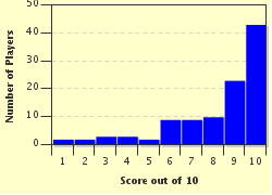
Score Distribution

quiz
Quiz Answer Key and Fun Facts
1. Cornwall is a peninsula in south-west England, with a northern coastline on the Atlantic Ocean and a southern coastline on the English Channel. Its only land border is with the neighbouring county of Devon to the east. What is the name of the river that defines Cornwall's boundary with Devon?

Answer: Tamar

Cornwall's location in the far south-west of England means that it has a particularly temperate climate compared to the rest of the country. This is mainly due to the presence of the Gulf Stream, an ocean current that provides warmer water around the Cornish coast.

The northern coast, exposed to the part of the Atlantic Ocean known as the Celtic Sea, is characterised by spectacular rugged cliffs. The highest sheer cliff face in Cornwall, aptly named High Cliff, is a dizzying 732 feet. The south coast is more sheltered and is colloquially known as the Cornish Riviera, a term dating back at least 100 years.

The River Tamar defines the majority of Cornwall's boundary with Devon, which is its only connection to the rest of England. The boundary is a traditional one, believed to date back to the reign of King Athelstan in the 10th century. The Thames, Severn and Exe are all English rivers, but are not in Cornwall.
2. Tintagel castle consists of the ruined remains of a 13th century medieval castle, which were built on an even older site dating back to at least the Roman period. However, the castle is more well-known for its connection with which legendary figure?

Answer: King Arthur

Tintagel's connections with Arthurian legend are believed to derive from the 12th century cleric, Geoffrey of Monmouth, who identified Tintagel as the birthplace of King Arthur. Geoffrey was a key figure in developing the tales of King Arthur through his book 'The History of the Kings of Britain'. Although the legends suggest that King Arthur was a historical British leader around the turn of the 6th century, there is little evidence for this and modern historians tend to dispute his existence. Despite this the castle has been a well-known tourist attraction for around 150 years. It is now owned and managed by English Heritage.

King Alfred was King of Wessex from 871 to 899, although he does feature in a legendary story where he burns a peasant woman's cakes! Sir Lancelot was one of the Knights of the Round Table who had an affair with King Arthur's wife, Queen Guinevere. Jack the Giant Killer is a character in Cornish myth.
3. A large area of northern Cornwall is covered by Bodmin Moor, most of which is classified as a Site of Special Scientific Interest (SSSI). What is the name of Cornwall's highest point, located on the moor?

Answer: Brown Willy

Brown Willy is the highest of the numerous granite tors which are dotted across Bodmin Moor. It stands at just under 1,400 feet and is surrounded by the remains of around forty prehistoric houses on its lower slopes. The summit itself has two manmade cairns which are believed to cover Bronze age burials.

Bodmin Moor is also known for sightings of a mysterious 'big cat' that was blamed for the unexplained deaths of livestock grazing there. Although official reports have declared that there is no evidence for the existence of such a creature, the phenomenon has become known as the Beast of Bodmin Moor.

Ben Nevis is the highest point in Scotland and the UK as a whole, Scafell Pike is the highest point in England, and Slieve Donard is the highest point in Northern Ireland.
4. Which Cornish village, a popular tourist destination and location for the television documentary 'A Seaside Parish', was severely damaged by flooding in August 2004?

Answer: Boscastle

On the 16th August 2004, localised heavy rain showers in the hills above Boscastle resulted in the river flowing through the village breaking its banks. The flash flood that followed caused water to surge down the main street at up to 40mph, flooding many properties, washing over 100 vehicles out to sea, and completely destroying some of the buildings. The event occurred at the height of the tourist season but miraculously nobody was killed.

The TV documentary programme 'A Seaside Parish', which had already been filming in Boscastle, captured the flood and its aftermath. It highlighted the effect of both the event and the lengthy rebuilding process on the community.

Boscastle is home to the Museum of Witchcraft. It has a wide collection of witchcraft artefacts, which at one time even included the skeleton of a witch! The woman had died at a local jail after being accused of witchcraft in 1813 and her skeleton used to be displayed in the museum. However, in the late 1990s she was given a funeral and buried in local woodland. Although damaged in the flood of 2004, the museum was able to reopen the next year.

Padstow, Port Isaac and Tintagel are all popular tourist destinations on the north Cornish coast.
5. Newquay, a town on the North Cornish coast, hosted the Beatles for three days in 1967 whilst they were filming their 'Magical Mystery Tour'. However, it is better known as a centre for which sport?

Answer: Surfing

The 'Magical Mystery Tour' was the third film made by the Beatles, and the first to be made directly for television. The plot centred around a group of people taking a mystery coach tour around the south of England and becoming embroiled in a number of strange events. These events were orchestrated by a group of magicians who were played by the band members. In between these scenes the Beatles played a number of their hit songs such as 'I am the Walrus' and 'Penny Lane'. The film was poorly received and particularly criticised for a lack of plot and generally confusing the audience. The fact the film was unscripted and largely unplanned was probably the cause of these complaints.

Newquay is known for its excellent surfing. It is a centre for the surfing industry in the UK, with a large number of surf related shops and businesses. Although Newquay has a golf course and cricket club it is not known as a centre for either of these sports. Newquay is also not known for its skiing opportunities, although jet-skiing on the water is certainly possible!
6. The most southerly point of mainland Great Britain is located in Cornwall. What is it called?

Answer: Lizard Point

Lizard Point is the most southerly point on the British mainland and is located on a peninsula known as the Lizard. The Lizard is one of England's most dangerous coasts for shipping to navigate, with many documented ship wrecks having occurred over the centuries. A lighthouse was first built at Lizard Point in 1619, although the current building dates to the mid 18th century.

In the 18th century Cornwall had a bad reputation as an area rife with smuggling and wrecking (where local people ransacked wrecked ships in order to salvage anything of value). These activities were particularly common in the area around the Lizard, probably due to both the large number of wrecks occurring and the poverty of the local population.

Mousehole is also in south Cornwall, but is slightly further north than Lizard Point. Ottery St Mary and Newton Abbot are both towns in neighbouring Devon.
7. Cornwall's geology has been a key part of its economy, with tin mining believed to have begun in the area during the Bronze Age. However, the geology also means that Cornwall has the highest levels in the UK of which naturally occurring radioactive gas (atomic number 86)?

Answer: Radon

High levels of radon gas are a health hazard as the gas has been linked to increased incidence of lung cancer in humans. It occurs naturally, formed from the radioactive decay of the small amounts of uranium found in most rocks and soils worldwide. A large part of Cornwall's geology is granite, which is one of the types of rock that generally produces higher levels of radon gas.

In 2012 the UK Health Protection Agency ran a campaign which offered free radon tests to households in south Cornwall as the gas can't be seen, smelled or tasted. The results showed that approximately 25 percent of houses tested needed some remedial action against the problem.

Argon, krypton and xenon are all in group 18 of the periodic table, alongside radon. All four elements are classified as noble gases.
8. One of Cornwall's best known tourist attractions is a tidal island, topped by a castle and the remains of a former abbey, and connected to the mainland by a causeway. What is the name of this striking Cornish feature?

Answer: St Michael's Mount

St Michael's Mount is a popular tourist destination that can only be reached by boat at high tide, although visitors can walk across the the causeway when the tide permits. The mount is thought to have become a religious site by the 6th century and was known as a place of pilgrimage during the Middle Ages. Following the Norman Conquest in 1066 the mount was granted to the abbey of Mont St Michel in Brittany. In addition to effectively having the same name, Mont St Michel is also a tidal island of very similar appearance to St Michael's Mount.

Ancient texts suggest that in the 11th century the mount was not an island but may have actually been miles inland. The 'Anglo-Saxon Chronicle' records a massive flood in 1099 which led to large areas of land being inundated by the sea. This may explain how St Michael's Mount came to be isolated from the mainland.

St Piran is widely regarded as the patron saint of Cornwall, St Columba was a 6th century Irish missionary and St Ives is a Cornish town. However, they are not names for a peak, crag or isle respectively.
9. The Isles of Scilly are a small archipelago located approximately 28 miles from the mainland. However, they are historically part of the ceremonial county of Cornwall. What is the name of the largest island, which accounts for approximately forty percent of the Isles of Scilly's total land area?

Answer: St Mary's

The Isles of Scilly are made up of five inhabited islands plus a large number of smaller islands and islets. St Mary's has an area of approximately 2.5 square miles, more than twice the size of the next largest island, Tresco.

The majority of land in the archipelago is the property of the Duchy of Cornwall, which was created in 1337 to provide an income for the heir apparent to the English throne. The economy of the islands is heavily dependent on tourism. It is a particularly good destination for ornithologists, as the islands are the first landing point in the UK for a number of migratory species.

St Martin's and St Agnes are the third and fourth largest islands in the archipelago respectively.
10. Land's End is the most westerly point in both Cornwall and England. It is a popular starting point for many charity fundraising challenges where people journey from Land's End to which location in north-east Scotland?

Answer: John o' Groats

Undertaking a Land's End to John o' Groats challenge means travelling from the most south-westerly point of Great Britain (Land's End) to the most north-easterly (John o' Groats). This is a distance of about 850 miles by road, although the straight line distance is only about 600 miles. John o' Groats is actually the nearest settlement to the most north-easterly point of Britain at nearby Duncansby Head.

The first known walk between the two places was completed by John and Robert Naylor in 1871. Many different methods have been used for the challenge including walking, running, wheelchair, cycling, car, public transport, and even motorised paraglider!

Thurso and Wick are the two of the closest towns to John o' Groats. Kirkwall is the capital of the Orkney Islands.
Source: Author Fifiona81

This quiz was reviewed by FunTrivia editor spanishliz before going online.
Any errors found in FunTrivia content are routinely corrected through our feedback system.
Related Quizzes
This quiz is part of series A Tour of the UK:

This selection of quizzes are all about regions or places around the United Kingdom.

  1. The UK's Amazing World Heritage Sites Average
  2. Bath Time! Average
  3. It's a Magical Mystery Tour of Cornwall! Easier
  4. A Passage to Hampshire Average
  5. Here in Hereford Average
  6. River Lea Average
  7. The History of Portsmouth Average
  8. Touring Scotland's Highlands and Islands Easier

1/21/2025, Copyright 2025 FunTrivia, Inc. - Report an Error / Contact Us