FREE! Click here to Join FunTrivia. Thousands of games, quizzes, and lots more!
Quiz about I Am Legend

I Am Legend Trivia Quiz


I am crucial. I am knowledge. I give direction. I make clear the confusing. I am on your map. I am legend!

A multiple-choice quiz by reedy. Estimated time: 5 mins.
  1. Home
  2. »
  3. Quizzes
  4. »
  5. Geography Trivia
  6. »
  7. Names, Maps and Borders
  8. »
  9. Maps

Author
reedy
Time
5 mins
Type
Multiple Choice
Quiz #
335,586
Updated
Dec 03 21
# Qns
10
Difficulty
Average
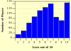
Avg Score
6 / 10
Plays
3329
Awards
Top 35% Quiz
Last 3 plays: Guest 136 (8/10), benjovi (7/10), Guest 60 (7/10).
- -
Question 1 of 10
1. There are many types of maps out there - topographical, political, climate, economic and road maps to name a few - but almost all maps have one common symbol on them that indicates the cardinal points, or at minimum where north is. What is it called? Hint


Question 2 of 10
2. On a topographic map, contour lines are used to show land elevation. All those irregularly shaped lines can be confusing, so your legend shows you what each type of line represents. Which of these types of contour line is the thickest, and is accompanied with a number indicating the elevation? Hint


Question 3 of 10
3. Many maps require the use of a scale to determine distances. If your map has a ratio of 1:50,000 then how far would one inch on the map get you in the real world? Hint


Question 4 of 10
4. The use of color on a map can vary greatly, depending on the type of map one is referring to. Generalities can often be made, however. For instance, blue typically represents water, and green usually refers to forested areas. On a typical road map or political map, what does yellow normally signify? Hint


Question 5 of 10
5. A problem to contend with when using a map for compass navigation is something called magnetic declination. Before you can use your compass, you need to know the proper adjustment to make so that it will work with your map. Which of these is not a factor that you need to consider? Hint


Question 6 of 10
6. Depending on the type of map that you need, it may be necessary for the legend to indicate what type of projection has been used to produce the map. Which of these is not an established type of map projection? Hint


Question 7 of 10
7. There are different types of relief maps, but the type that shows elevation as bands of color is called a hypsometric tint map. The legend on this kind of relief map would show what color as the highest elevation? Hint


Question 8 of 10
8. Different economic factors in our world are often represented on maps, using a color-scheme to identify each country's standing. It is important to check the map legend to determine what kind of economic map it is. Which of the following would not be found in an economic map's legend? Hint


Question 9 of 10
9. Probably one kind of map we see most often is the weather map on your local television news broadcasts. Movement of air masses is shown by 'fronts' and use lines with colors and shapes to represent different types of fronts. What does a blue line with blue triangles on it represent? Hint


Question 10 of 10
10. If you are the type of person who has evolved to GPS usage, do not fret! There are legends for the symbols on your digital maps as well. If you use a Garmin GPS, for instance, what does an anchor represent? Hint


(Optional) Create a Free FunTrivia ID to save the points you are about to earn:

arrow Select a User ID:
arrow Choose a Password:
arrow Your Email:


Most Recent Scores
Oct 30 2024 : Guest 136: 8/10
Oct 20 2024 : benjovi: 7/10
Oct 15 2024 : Guest 60: 7/10
Oct 14 2024 : auto_enigma: 5/10
Oct 06 2024 : Reveler: 9/10
Oct 05 2024 : Guest 107: 7/10
Sep 25 2024 : ChunkyWeenie: 9/10
Sep 24 2024 : Guest 184: 6/10
Sep 23 2024 : Guest 192: 6/10

Score Distribution

quiz
Quiz Answer Key and Fun Facts
1. There are many types of maps out there - topographical, political, climate, economic and road maps to name a few - but almost all maps have one common symbol on them that indicates the cardinal points, or at minimum where north is. What is it called?

Answer: A compass rose

The origins of a map's compass rose are intertwined with the development of the magnetic compass. Researchers have found that the earliest evidence of a refined magnetic compass places the invention in the early 1200s, although no one inventor can be named.

Prior to the use of compass roses on maps, lines were drawn from central points on the map and were hard to follow due to the convergence of many such lines. The rose made it easier to read maps, and better maps (designed for magnetic compass use) made for better navigation. Before long, more precise navigational ability led to year-round travel, and consequently, more trade.

The compass rose has four cardinal points (north, east, south, west), four ordinal points (NE, SE, SW, NW), and when fully drawn, an additional 24 points are added to gain more precise bearings. Reciting all 32 points is called 'boxing the compass.'
2. On a topographic map, contour lines are used to show land elevation. All those irregularly shaped lines can be confusing, so your legend shows you what each type of line represents. Which of these types of contour line is the thickest, and is accompanied with a number indicating the elevation?

Answer: Index

The interval between contour lines will vary with the map, and most often depends on the scale of the map, and the measurement being used (imperial vs metric).

Contour lines are not limited to showing land elevation, but that is their primary use on a topographic map. When used in other forms, they typically carry a defining name to differentiate their purpose. Examples of this include 'isopleth' (used to measure a quantity, such as population density), 'isobar' (indicating barometric air pressure), 'isotherm' (indicating zones of similar temperature), and 'isohyet' (shows areas of equal precipitation). There are as many more types of contour line as there are ways to imagine showing how something is distributed.
3. Many maps require the use of a scale to determine distances. If your map has a ratio of 1:50,000 then how far would one inch on the map get you in the real world?

Answer: 1,388 yards, 2 feet, 8 inches (0.789 miles)

Twelve inches in a foot, three feet in a yard, 1,760 yards in a mile. It just takes a little figuring. In addition to the correct answer, the options presented gave the scales for one inch at a ratio of 1:25,000, 1:75,000 and 1:100,000.
4. The use of color on a map can vary greatly, depending on the type of map one is referring to. Generalities can often be made, however. For instance, blue typically represents water, and green usually refers to forested areas. On a typical road map or political map, what does yellow normally signify?

Answer: Urban areas

Because color usage can vary between maps (green could mean low elevation, for instance), it is important to refer to the legend to ensure the correct interpretation of the map. It would be unfortunate to follow a road map, believing your route an excellent one, only to find yourself turning onto an aqueduct!
5. A problem to contend with when using a map for compass navigation is something called magnetic declination. Before you can use your compass, you need to know the proper adjustment to make so that it will work with your map. Which of these is not a factor that you need to consider?

Answer: Elevation

To adjust your compass to work with your map, there is no need to know your elevation. Here's what you DO need to know:

True north/south - your map grid lines (or at least your compass rose) are in alignment with the geographical poles - the axis around which the earth spins;

Magnetic north/south - this is where your compass points. The earth's magnetic field is created by magnetic elements in the earth's fluid outer core, and this does not align with the geographical poles;

Age of the map - your map's production year will cite the magnetic declination (angle difference from true north/south), and then will tell you how much that will change EVERY YEAR.

Thus if your map is 20 years old, you'll have to alter the stated declination by the 'approximate annual change' times 20, and then make the necessary adjustment to your compass to get an accurate magnetic compass reading.
6. Depending on the type of map that you need, it may be necessary for the legend to indicate what type of projection has been used to produce the map. Which of these is not an established type of map projection?

Answer: Franklin projection

Map projections are termed as such because maps that are flat have been made so from a projection from a curved surface (an effort to make the globe, or portions thereof, representable on a piece of paper).

One style of map projection is called azimuthal, an example of which is the Gnonomic. The Gnonomic projection is believed to be the oldest type of projection, developed by Thales in the 6th century BC. "A gnomonic map projection displays all great circles as straight lines. Thus the shortest route between two locations in reality corresponds to that on the map."

The Mercator projection is a type of cylindrical projection. "The term "normal cylindrical projection" is used to refer to any projection in which meridians are mapped to equally spaced vertical lines and circles of latitude (parallels) are mapped to horizontal lines."

Pseudocylindrical projections, such as the Collignon projection, "represent the central meridian and each parallel as a single straight line segment, but not the other meridians."

Quotes taken from Wikipedia
7. There are different types of relief maps, but the type that shows elevation as bands of color is called a hypsometric tint map. The legend on this kind of relief map would show what color as the highest elevation?

Answer: White

It is Leonardo da Vinci who was credited with the first utilization of color to represent elevation in his map of central Italy, circa 1502.

The Scottish map firm John Bartholomew and Son made this type of map more popular, and their color scheme has become the standard for the cartographic world: greens at the lowest elevations, progressing up through yellows and ochers to browns and grays, then finally white at the highest elevations. Often, hypsometric maps include bathymetric tinting in the oceans as well, getting progressively darker shades of blue with greater depth.

Other types of relief maps include raised (3-D representation), hachure (showing orientation of slope), contour line (topographical), and shaded (simulating light shadows on raised features).
8. Different economic factors in our world are often represented on maps, using a color-scheme to identify each country's standing. It is important to check the map legend to determine what kind of economic map it is. Which of the following would not be found in an economic map's legend?

Answer: Elevation

The impact of population distribution and density is really the driving force behind any economic considerations. After all, where people are, there lies an economy.

"Gross domestic product (GDP) refers to the market value of all goods and services produced within a country in a given period. It is often considered an indicator of a country's standard of living."

"The Human Development Index (HDI) is a comparative measure of life expectancy, literacy, education and standards of living for countries worldwide. It is a standard means of measuring well-being, especially child welfare. It is used to distinguish whether the country is a developed, a developing or an under-developed country, and also to measure the impact of economic policies on quality of life."

Quotes taken from Wikipedia
9. Probably one kind of map we see most often is the weather map on your local television news broadcasts. Movement of air masses is shown by 'fronts' and use lines with colors and shapes to represent different types of fronts. What does a blue line with blue triangles on it represent?

Answer: A cold front

When you see the symbol for a cold front, it represents a zone separating two air masses, of which the cooler, denser mass is advancing and replacing the warmer. A warm front is shown as a red line with red half-circles, while a stationary front is a combination of the two, showing a front between cold and warm air masses that is moving very slowly, or possibly not at all.

A bit more complicated to explain is an occluded front. A description from the National Weather Service states that an occluded front is "a composite of two fronts, formed as a cold front overtakes a warm or quasi-stationary front. Two types of occlusions can form depending on the relative coldness of the air behind the cold front to the air ahead of the warm or stationary front. A cold occlusion results when the coldest air is behind the cold front and a warm occlusion results when the coldest air is ahead of the warm front."
10. If you are the type of person who has evolved to GPS usage, do not fret! There are legends for the symbols on your digital maps as well. If you use a Garmin GPS, for instance, what does an anchor represent?

Answer: A marina

Global Positioning Systems take a lot of the work of navigation out of the equation. But as with many things technological, one must temper reliance on technology with personal skill and knowledge. If you run out of batteries, and do not know basic survival skills (including navigation), it could make for a dangerous situation.

Always make sure that you have a backup to your technology, especially if you are in the wilderness.
Source: Author reedy

This quiz was reviewed by FunTrivia editor Pagiedamon before going online.
Any errors found in FunTrivia content are routinely corrected through our feedback system.
Related Quizzes
This quiz is part of series Author Rainbow: My Tier 2 Set:

With the new Author Rainbow badgelets, I found another excuse to create more quiz lists. Tier 2 is achieved when you write five quizzes in a category. Here is a list of the fifth quiz I wrote in each category - in the order I completed them - making a full set of Tier 2 badgelets. Have fun!

  1. Ancient Civilizations Average
  2. Rising Winds of "The Wheel of Time" Tough
  3. How Can You NOT Know These? Average
  4. That's So Punny! Average
  5. "The 39 Clues" Book 5: "The Black Circle" Average
  6. Category Crunch Tough
  7. A Sabbatical in Suriname Average
  8. I Am Legend Average
  9. Trekkin' Through The Alphabet (G) Average
  10. The Return of the Winnipeg Jets Average
  11. Engineer's Log - Geordi La Forge Average
  12. Got your 'Bering'? Let's explore! Average

10/31/2024, Copyright 2024 FunTrivia, Inc. - Report an Error / Contact Us