FREE! Click here to Join FunTrivia. Thousands of games, quizzes, and lots more!
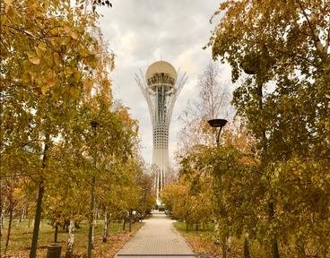
Quiz about A Handy Guide to Kazakhstan

A Handy Guide to Kazakhstan Trivia Quiz


Are you after some basic facts about Kazakhstan? Then this quiz on the Central Asian nation might be just the thing you need. Try it and find out...

A photo quiz by Fifiona81. Estimated time: 4 mins.
  1. Home
  2. »
  3. Quizzes
  4. »
  5. Geography Trivia
  6. »
  7. Asia
  8. »
  9. Kazakhstan

Author
Fifiona81
Time
4 mins
Type
Photo Quiz
Quiz #
406,781
Updated
Dec 03 21
# Qns
10
Difficulty
Average
Avg Score
7 / 10
Plays
193
Awards
Top 20% Quiz
Last 3 plays: Guest 39 (5/10), 1nn1 (10/10), Upstart3 (6/10).
-
Question 1 of 10
1. Kazakhstan's capital city was renamed in honour of the country's first president in 2019. What was his name? Hint


Question 2 of 10
2. In 1993 Kazakhstan became a founder member of which international cultural organisation along with Azerbaijan, Kyrgyzstan, Turkey, Turkmenistan and Uzbekistan? Hint


Question 3 of 10
3. What type of geographical feature characterises a large part of northern Kazakhstan also known as the Great Dala? Hint


Question 4 of 10
4. The Aralkum Desert in southern Kazakhstan (and northern Uzbekistan) didn't exist prior to 1960. What caused it to develop? Hint


Question 5 of 10
5. Located close to the Caspian Sea in western Kazakhstan, Karagiye has a name that means "Black Jaw" in Turkic. What geographical point of Kazakhstan can be found there? Hint


Question 6 of 10
6. With which of its five neighbours does Kazakhstan have the shortest land border? Hint


Question 7 of 10
7. Reaching up to a point over 1,000 metres above sea level, which of these is a prominent landmark visible from Kazakhstan's largest city? Hint


Question 8 of 10
8. What type of bird is featured on the flag of Kazakhstan? Hint


Question 9 of 10
9. If you visited the UNESCO World Heritage Site at Tanbaly (or Tamgaly) in southern Kazakhstan, what would you expect to see there? Hint


Question 10 of 10
10. Kazakhstan is well-known for being the biggest landlocked nation in the world, but approximately how much larger is it than second-placed Mongolia? Hint


(Optional) Create a Free FunTrivia ID to save the points you are about to earn:

arrow Select a User ID:
arrow Choose a Password:
arrow Your Email:


View Image Attributions for This Quiz

Most Recent Scores
Nov 12 2024 : Guest 39: 5/10
Nov 04 2024 : 1nn1: 10/10
Oct 25 2024 : Upstart3: 6/10

Quiz Answer Key and Fun Facts
1. Kazakhstan's capital city was renamed in honour of the country's first president in 2019. What was his name?

Answer: Nursultan Nazarbayev

Kazakhstan's capital city, Nur-Sultan, gained that name in March 2019 following the departure of Nursultan Nazarbayev as the Kazakh President after nearly 29 years in office. It is located centrally in the north of the country and was originally settled by Siberian Cossacks in the 1830s. It was originally named Akmola but became known as Akmolinsk from 1832. It became the country's capital in December 1997 and renamed Astana (meaning "capital city") in May 1998.

The incorrect options were the first three men to serve as prime minister following Kazakhstan's independence from the Soviet Union.
2. In 1993 Kazakhstan became a founder member of which international cultural organisation along with Azerbaijan, Kyrgyzstan, Turkey, Turkmenistan and Uzbekistan?

Answer: TURKSOY

TURKSOY is the abbreviation used by the International Organisation of Turkic Culture - a body set up in 1993 to promote the culture of those countries who speak Turkic languages. In addition to Turkish, Azerbaijani, Kyrgyz, Turkmen, Uzbek and Kazakh (official languages of the six founding nations), other languages in this group include Tatar, Bashkir, Khakas, Gagauz and Uyghur. A number of regional areas of Russia and Moldova that speak some of these languages have also been admitted as observer members of TURKSOY.

In 2012, TURKSOY began nominating an annual Culture and Arts Capital of the Turkic World. The first city to hold this title was Kazakhstan's capital - then known as Astana.

The Turkic Council is an umbrella organisation that, among others, includes TURKSOY, TURKPA (the Parliamentary Assembly of the Turkic Speaking Countries) and the International Turkic Academy.
3. What type of geographical feature characterises a large part of northern Kazakhstan also known as the Great Dala?

Answer: Steppe

The Great Dala is another name for the Kazakh Steppe - a large area of land characterised by grass and shrubs, which covers much of the northern half of the country and extends into southern Russia. This type of biome has several different names depending on the area of the world in which it is found. In central Asia it is called a steppe, but in North and South America it is referred to respectively as prairie and pampas, while in southern Africa it is known as veld.

The Kazakh Steppe is largely temperate, but it receives relatively little rainfall and its southern section is mainly arid or semi-arid.
4. The Aralkum Desert in southern Kazakhstan (and northern Uzbekistan) didn't exist prior to 1960. What caused it to develop?

Answer: Shrinking of the Aral Sea

The Aralkum Desert occupies an area that was once the Aral Sea - a large endoreic lake that covered around 68,000 square kilometres (26,000 square miles) in 1960. At that point it was the fourth-largest lake in the world behind the Caspian Sea at the other side of Kazakhstan, Lake Superior in North America and Lake Victoria in Africa. The lake began to dry up after this point as a result of large-scale Soviet irrigation programmes that diverted the water from the Aral Sea's main inflow, the Syr Darya River. Fifty years later in 2010, the Aral Sea had been reduced to a number of small lakes around the northern and eastern edges of its former area.

The Aralkum Desert consists of the sandy surface of the former seabed and is heavily polluted by agricultural pesticides, dried up salts and toxins and the remains of shipwrecks that provide a vivid image of how drastically the landscape changed in less than half a century.
5. Located close to the Caspian Sea in western Kazakhstan, Karagiye has a name that means "Black Jaw" in Turkic. What geographical point of Kazakhstan can be found there?

Answer: Lowest point

Karagiye is also known as the Karagiye Mountain Trench or the Karagiye Depression. The trench was formed by the collapse of a type of geology known as karst, where limestone and other porous rocks are undermined by erosion and underground drainage systems in the form of sinkholes, caverns and fissures.

It is around 40 kilometres (25 miles) in length and extends down to over 130 metres (425 feet) below sea level. Its deepest point, Vpadina Kaundy, is also the lowest point in the whole of Kazakhstan.
6. With which of its five neighbours does Kazakhstan have the shortest land border?

Answer: Turkmenistan

Kazakhstan's southern border with Turkmenistan runs from the Caspian Sea in the west, around the Garabogazköl lagoon and about halfway across the Ustyurt plateau to a tripoint between Kazakhstan, Turkmenistan and Uzbekistan. In total it is just over 400 kilometres (250 miles) in length and therefore it is the shortest of Kazakhstan's boundaries with its neighbours.

The remainder of Kazakhstan's southern border consists of 2,300 kilometres (1,450 miles) shared with Uzbekistan and 1,200 kilometres (750 miles) shared with Kyrgyzstan, plus a 1,750 kilometres (1,100 miles) border with China to the south-east. The country's entire northern border is with Russia and that stretches for over 7,600 kilometres (1,000 miles).
7. Reaching up to a point over 1,000 metres above sea level, which of these is a prominent landmark visible from Kazakhstan's largest city?

Answer: Almaty Television Tower

The Almaty Television Tower (also just known as the Almaty Tower) is not over 1,000 metres tall, but because it is built on the Kok Tobe Mountain, the top of its antenna reaches up to about 1,450 metres above sea level despite the tower itself being "only" 372 metres tall. The tower is a prominent landmark in the Kok Tobe Park, which also includes a roller coaster, Ferris wheel, restaurants, concert venue and other attractions. The park can be accessed from Almaty via a cable car.

The tower took eight years to build and on its completion in 1983 it became the world's tallest free-standing tubular steel structure.
8. What type of bird is featured on the flag of Kazakhstan?

Answer: Eagle

Kazakhstan's flag has a sky blue field, with a golden sun in the centre with a gold stylised eagle flying beneath it. There is also a gold decorative motif called a koshkar-muiz on the hoist side. The eagle is specifically a steppe eagle (Aquila nipalensis), which is a migratory species that spends its summer breeding season in the steppe region of northern Kazakhstan and areas of Russia, China and Mongolia.

Eagles are by far the most common bird to appear on a country's national flag. Other countries that have honoured these majestic creatures in that way include Albania, Egypt, Mexico and Zambia.
9. If you visited the UNESCO World Heritage Site at Tanbaly (or Tamgaly) in southern Kazakhstan, what would you expect to see there?

Answer: Petrogylphs

The "Petroglyphs within the Archaeological Landscape of Tanbaly" became Kazakhstan's second UNESCO World Heritage Site when they were added to the list in 2004. The site is located about 170 kilometres (105 miles) north-west of the city of Almaty towards the south-east of the country. The petroglyphs can be found in dozens of places throughout the Tanbaly Gorge in the Chu-Ili mountains, but there are five main locations that together account for about 3,000 of the 5,000 or so petroglyphs that have been recorded at the site.

Petroglyphs are essentially rock carvings, pictorial images that have been incised, picked or engraved into rock surfaces. The examples at Tanbaly largely date from the middle Bronze Age to the early Iron Age and depict humans, animals, mythological scenes and images of what life must have been like during that period.
10. Kazakhstan is well-known for being the biggest landlocked nation in the world, but approximately how much larger is it than second-placed Mongolia?

Answer: 1.7 times larger

Kazakhstan has a total land area of around 2.72 million square kilometres (1.05 million square miles) compared to Mongolia's 1.56 million (602,000), making it approximately 1.7 times larger than its nearest landlocked rival. It is just over twice the size of Chad, the third-largest landlocked country in the world and over 6 million times larger than the smallest landlocked nation, Vatican City. Kazakhstan is also partially responsible for the double-landlocking of one of its neighbours, Uzbekistan.

Kazakhstan makes the list of the top ten largest countries in the world - it comes in ninth place, as it is just slightly smaller than Argentina.
Source: Author Fifiona81

This quiz was reviewed by FunTrivia editor agony before going online.
Any errors found in FunTrivia content are routinely corrected through our feedback system.
Related Quizzes
This quiz is part of series A Handy Guide to...:

Are you after some basic facts about countries and places around the world? Then these quizzes might be just the thing you need. Try them and find out...

  1. A Handy Guide to the Caribbean Easier
  2. A Handy Guide to Colombia Easier
  3. A Handy Guide to Ethiopia Average
  4. A Handy Guide to Fiji Average
  5. A Handy Guide to Kazakhstan Average
  6. A Handy Guide to Mauritius Average
  7. A Handy Guide to Papua New Guinea Average
  8. A Handy Guide to Paraguay Average
  9. A Handy Guide to Singapore Average
  10. A Handy Guide to Spain Average
  11. A Handy Guide to Vanuatu Average
  12. A Handy Guide to Venezuela Easier

12/21/2024, Copyright 2024 FunTrivia, Inc. - Report an Error / Contact Us