FREE! Click here to Join FunTrivia. Thousands of games, quizzes, and lots more!
Quiz about A Handy Guide to Mauritius

A Handy Guide to Mauritius Trivia Quiz


Are you after some basic facts about Mauritius? Then this quiz on the African island nation might be just the thing you need. Try it and find out...

A photo quiz by Fifiona81. Estimated time: 4 mins.
  1. Home
  2. »
  3. Quizzes
  4. »
  5. Geography Trivia
  6. »
  7. Africa
  8. »
  9. Mauritius

Author
Fifiona81
Time
4 mins
Type
Photo Quiz
Quiz #
387,521
Updated
Sep 04 23
# Qns
10
Difficulty
Average
Avg Score
7 / 10
Plays
1828
Awards
Top 10% Quiz
Last 3 plays: misstified (10/10), Guest 102 (9/10), portalrules123 (9/10).
-
Question 1 of 10
1. Mauritius is an island nation located around 2,000 kilometres (1,200 miles) from the African mainland. In what body of water would you have to look in order to find it? Hint


Question 2 of 10
2. In 1965, prior to Mauritian independence from the UK, an archipelago of around 60 islands was transferred from Mauritian territory to form the new British Indian Ocean Territory. What is the name of this archipelago, whose sovereignty caused significant disputes between Mauritius and the UK? Hint


Question 3 of 10
3. Mauritius became a founding member of which of these international organisations in 1970? Hint


Question 4 of 10
4. Mauritius Island accounts for the majority of the land area of the nation of Mauritius. What is the name of country's second largest island, located about 550 kilometres (350 miles) east of its larger neighbour? Hint


Question 5 of 10
5. Trou aux Cerfs is one of the most distinctive geological features of Mauritius. What is it? Hint


Question 6 of 10
6. Mauritius is famous for having been the home of the dodo, the ubiquitous symbol of extinction. However, other birds endemic to the country survived into the 21st century. Which of these is one of them? Hint


Question 7 of 10
7. The capital city of Mauritius is the country's major port and centre for trade as well as housing the seat of government. For which 18th century European monarch was the city named? Hint


Question 8 of 10
8. Since the 1960s, the economy of Mauritius has developed away from a reliance on agriculture to include tourism, financial services, renewable energy and other service sector industries. However, which agricultural product remained a key export into the 21st century? Hint


Question 9 of 10
9. Which of these is a popular style of music in Mauritius that is usually sung in Mauritian Creole? Hint


Question 10 of 10
10. The south-western section of the main island of Mauritius is home to a national park that contains the majority of the country's rainforest. What is it called? Hint


(Optional) Create a Free FunTrivia ID to save the points you are about to earn:

arrow Select a User ID:
arrow Choose a Password:
arrow Your Email:


View Image Attributions for This Quiz

Most Recent Scores
Jan 11 2025 : misstified: 10/10
Jan 11 2025 : Guest 102: 9/10
Jan 05 2025 : portalrules123: 9/10
Jan 04 2025 : Guest 136: 8/10
Dec 25 2024 : Guest 185: 7/10
Dec 22 2024 : klukblazen: 5/10
Dec 18 2024 : Guest 82: 4/10

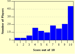
Score Distribution

quiz
Quiz Answer Key and Fun Facts
1. Mauritius is an island nation located around 2,000 kilometres (1,200 miles) from the African mainland. In what body of water would you have to look in order to find it?

Answer: Indian Ocean

Mauritius is located in the western Indian Ocean and is also separated from the African mainland by the much larger island of Madagascar. The islands that make up the country are volcanic in origin and are believed to have formed following intensive volcanic activity around eight to ten million years ago. As a result the terrain is rocky and mountainous, with Mauritius Island in particular containing a mountain range that reaches heights of around 300 to 800 metres (1,000 to 2,600 feet) above sea level.

All of the incorrect options are seas or oceans on which the African continent has a coastline. The Atlantic Ocean is to the west, the Red Sea to the north-east and the Mediterranean Sea to the north.
2. In 1965, prior to Mauritian independence from the UK, an archipelago of around 60 islands was transferred from Mauritian territory to form the new British Indian Ocean Territory. What is the name of this archipelago, whose sovereignty caused significant disputes between Mauritius and the UK?

Answer: Chagos Islands

The largest and best-known of the Chagos Islands is Diego Garcia, which was turned into a US military base in the early 1970s. As part of this process the inhabitants of the island were forcibly resettled elsewhere in the area, including on Mauritius itself. It, along with its smaller neighbours (see the picture clue for some of their names) had been British territories administered from Mauritius up until the time of Mauritian independence. The status of the sovereignty of the area, as well as arguments over the rights of the displaced population of Diego Garcia, continued to cause diplomatic tensions between the Republic of Mauritius and the UK into the 21st century.

The incorrect options are all island groups of the Indian Ocean. The Andaman Islands belong to India and are located in the Bay of Bengal; the Dahlak Archipelago can be found off the coast of Eritrea; and the Dampier Archipelago is off the north-west coast of Australia.
3. Mauritius became a founding member of which of these international organisations in 1970?

Answer: La Francophonie

La Francophonie is an international organisation for countries or regions of countries that have significant numbers of French speakers (or francophones) in their population or a particularly strong link to French culture. Its full title is Organisation Internationale de la Francophonie. Mauritius was one of the 21 original member states that formed the group in 1970; by the 21st century the group had expanded to include over 80 nations or territories - as highlighted on the map shown in the picture clue. Interestingly, African states, including Mauritius, made up more than half of the original members (12 out of the 21) - a fact that highlights the large number of former French colonies on the continent.

Mauritius is not an oil-producing nation, so it is very unlikely to become a member of OPEC - the Organisation of the Petroleum Exporting Countries. It joined the Commonwealth of Nations on its independence from the UK in 1968, but was by no means a founding member as the Commonwealth was first set up in 1931. The Arab League was formed in 1945, over 30 years before Mauritius became an independent state, and is a regional organisation for Arabia, the horn of Africa and north Africa - Mauritius is located a good bit further south and is actually a member of the African Union and the Indian Ocean Commission.
4. Mauritius Island accounts for the majority of the land area of the nation of Mauritius. What is the name of country's second largest island, located about 550 kilometres (350 miles) east of its larger neighbour?

Answer: Rodrigues Island

Mauritius is mainly located in the Mascarene Islands, which includes its two main islands of Mauritius and Rodrigues as well as the French overseas department of Réunion and two remnants of former volcanic islands - Cargados Carajos and Saya de Malha. The majority of the country's population lives on Mauritius Island, but Rodrigues Island has an area of around 100 square kilometres (40 square miles) and a sizeable population. It was granted some political autonomy in 2002 with the formation of the Rodrigues Regional Assembly in its capital, a village named Port Mathurin. The picture clue shows a map of the island from 1780.

In addition to Mauritius Island and Rodrigues Island, the remainder of Mauritius is accounted for by two outer island groups, St. Brandon and Agaléga. These two small land masses are respectively approximately 430 kilometres (270 miles) and 1,000 kilometres (620 miles) north of Mauritius Island - so for a small island nation, Mauritius is spread over a pretty big area and has control of a large maritime Exclusive Economic Zone.
5. Trou aux Cerfs is one of the most distinctive geological features of Mauritius. What is it?

Answer: Volcano

The coastline of Mauritius may be surrounded by coral reefs that form beautiful lagoons and the mountainous interior may include some spectacular waterfalls, but Trou aux Cerfs is a less watery geological feature of the country. In fact it is also known as Murr's Volcano and has a distinctive cone and crater, which measures around 300 to 350 metres (1,000 to 1,150 feet) in diameter. However, it is not entirely water-free as its crater contains a significant amount of silt and water. The picture clue shows a crater lake - but it is not an actual image of Trou aux Cerfs.

Trou aux Cerfs is located close to the town of Curepipe, in the mountainous central area of Mauritius Island. It is a popular tourist destination and the road that encircles the rim provides excellent views of both the surrounding countryside and the contents of the crater. More adventurous tourists can even hike down into the crater - but the path is difficult and can prove somewhat dangerous.
6. Mauritius is famous for having been the home of the dodo, the ubiquitous symbol of extinction. However, other birds endemic to the country survived into the 21st century. Which of these is one of them?

Answer: Pink pigeon

Mauritius' pink pigeon did survive into the 21st century, but suffered a serious scare in the 1990s when its known population dwindled to just ten birds. The rest of the island's endemic pigeon species have already been lost to extinction. The pink pigeon can be identified by the pale pink plumage on its head, breast and underparts; its dark pink and white beak; its pink feet; and its very dark pink (aka red) tail feathers. After reading that description (and studying the specimen presented in the picture clue) the reason behind its name should, frankly, have become obvious.

The existence of the dodo first came to the attention of westerners when Dutch sailors visited Mauritius in 1598. It then probably took less than 75 years for the poor bird to be wiped out of existence by a combination of hunting and habitat destruction. The dodo bore many similarities to members of the pigeon family - notably the structure of its forehead, nostrils and crop - and its closest living relation is the Nicobar pigeon.

The incorrect options are real birds but none of them are endemic to Mauritius.
7. The capital city of Mauritius is the country's major port and centre for trade as well as housing the seat of government. For which 18th century European monarch was the city named?

Answer: King Louis XV of France

The capital city of Mauritius is Port Louis. It has been a harbour since the early 17th century, but was developed by the French in the 1730s as the administrative centre of Isle de France - the name given to Mauritius when it came under French control in 1715. King Louis XV, also known as Louis the Beloved, was the French monarch from 1715 to 1774, having succeeded his great-grandfather, the "Sun King", at just five years of age. The picture clue shows a statue depicting the king as the Roman god Jupiter.

The incorrect options were all also 18th century European monarchs. King Frederick V of Denmark reigned from 1746 to 1766; George II was on Great Britain's throne from 1727 to 1760; and Charles III was King of Spain from 1759 to 1788.
8. Since the 1960s, the economy of Mauritius has developed away from a reliance on agriculture to include tourism, financial services, renewable energy and other service sector industries. However, which agricultural product remained a key export into the 21st century?

Answer: Sugar

The picture clue shows a photo of a sugar cane field in Mauritius (and a bicycle, but that is definitely a red herring in this case). In fact, Mauritius' sugar industry produces both sugar cane and sugar beet. Together the two account for around 10% of the country's exports and a very high proportion of the use of its agricultural land.

Tourism is also one of the major sectors of the Mauritian economy. This is probably unsurprising given the country's tropical climate; exotic wildlife; beautiful sandy beaches; warm coastal lagoons; and breath-taking views of mountains, volcanoes and rainforests.
9. Which of these is a popular style of music in Mauritius that is usually sung in Mauritian Creole?

Answer: Sega

Traditionally played with instruments such as the ravanne (drum), maravanne (rattle) and triangle, sega music is sung in the local creole languages - there are different dialects spoken on Mauritius' various islands - and is accompanied by a swaying dance during which the performer's feet do not leave the ground. Historically, sega music was created by the slave population of Mauritius and is derived from the music of Africa and Madagascar. A modern variety of sega is a form known as santé engagé, where the songs are a form of political protest against injustice and oppression.

Although sega music is entirely unrelated to the Japanese video game company of the same name, the picture clue provides a hint towards the famous Sega character of Sonic the Hedgehog (although admittedly Sonic doesn't really look anything like Erinaceus europaeus). The incorrect options are all other companies that produce video games and video game systems.
10. The south-western section of the main island of Mauritius is home to a national park that contains the majority of the country's rainforest. What is it called?

Answer: Black River Gorges National Park

The Black River Gorges National Park was founded in 1994 and is the oldest National Park in Mauritius. The picture clue is a photo of one of the steep, narrow gorges surrounded by rainforest through which the Rivière Noire (Black River) flows. The majority of the park can only be accessed via hiking trails, but any active tourists who venture out into the area get to see breath-taking views, beautiful waterfalls and a wide selection of the exotic flora and fauna of the area. A few of the park's attractions, including its visitor centres and some viewpoints, can be reached by car - so don't despair if tramping around a rainforest in hot, humid conditions is not your idea of a fun holiday activity!

Bras d'Eau National Park is in north-east Mauritius and the Islets National Park is a group of islands off Mauritius' north-east coast. However, Banc d'Arguin National Park is in the similarly-named African nation of Mauritania.
Source: Author Fifiona81

This quiz was reviewed by FunTrivia editor agony before going online.
Any errors found in FunTrivia content are routinely corrected through our feedback system.
Related Quizzes
This quiz is part of series A Handy Guide to...:

Are you after some basic facts about countries and places around the world? Then these quizzes might be just the thing you need. Try them and find out...

  1. A Handy Guide to the Caribbean Easier
  2. A Handy Guide to Colombia Easier
  3. A Handy Guide to Ethiopia Average
  4. A Handy Guide to Fiji Average
  5. A Handy Guide to Kazakhstan Average
  6. A Handy Guide to Mauritius Average
  7. A Handy Guide to Papua New Guinea Average
  8. A Handy Guide to Paraguay Average
  9. A Handy Guide to Singapore Average
  10. A Handy Guide to Spain Average
  11. A Handy Guide to Vanuatu Average
  12. A Handy Guide to Venezuela Easier

1/20/2025, Copyright 2025 FunTrivia, Inc. - Report an Error / Contact Us