FREE! Click here to Join FunTrivia. Thousands of games, quizzes, and lots more!
Quiz about A Handy Guide to the Caribbean

A Handy Guide to the Caribbean Quiz


Are you after some basic facts about Caribbean countries? Then this quiz on the region might be just the thing you need. Try it and find out...

A photo quiz by Fifiona81. Estimated time: 3 mins.
  1. Home
  2. »
  3. Quizzes
  4. »
  5. Geography Trivia
  6. »
  7. Central America
  8. »
  9. Caribbean

Author
Fifiona81
Time
3 mins
Type
Photo Quiz
Quiz #
376,054
Updated
Dec 03 21
# Qns
10
Difficulty
Easy
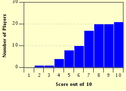
Avg Score
8 / 10
Plays
979
Awards
Top 5% quiz!
Last 3 plays: Guest 98 (10/10), Guest 87 (10/10), Guest 47 (10/10).
-
Question 1 of 10
1. The countries of Haiti and the Dominican Republic can both be found on the Caribbean's second largest island. By what name, derived from one given to it by Christopher Columbus, is it now known? Hint


Question 2 of 10
2. Which Dutch island in the Lesser Antilles shares its name with a liqueur flavoured with the peel of the laraha fruit? Hint


Question 3 of 10
3. The Caribbean Community (CARICOM), a group formed by various Caribbean nations and dependent territories, was set up by the Treaty of Chaguaramas in 1973. Which of the original four signatories is NOT a Caribbean island nation? Hint


Question 4 of 10
4. Which British Overseas Territory, located approximately 500 km (310 miles) north-west of Jamaica, is named after a species of the genus Crocodylus?
Hint


Question 5 of 10
5. The Caribbean Sea and its many island nations are located on the Caribbean tectonic plate. What name is given to the trench that marks part of the boundary between the Caribbean plate and the North American plate and contains the deepest point of the Atlantic Ocean? Hint


Question 6 of 10
6. Bequia, Canouan, Carriacou and Mustique are all located in which island chain (part of the Windward Islands) whose ownership is divided between two independent nations?
Hint


Question 7 of 10
7. Pico Duarte, the highest point on any Caribbean island, is located in the Cordillera Central mountain range in which country? Hint


Question 8 of 10
8. Many of the islands in the Lesser Antilles were named after various saints following their discovery by European explorers, but to which country do the islands of Saint Thomas, Saint John and Saint Croix belong? Hint


Question 9 of 10
9. Tourism is one of the major contributors to the economies of Caribbean island nations and grew massively during the 20th century as a result of improved transport links and the development of the 'package holiday'. However, the Caribbean's first hotel aimed squarely at tourists opened in the late 18th century on which island that was then a British colony? Hint


Question 10 of 10
10. On which Caribbean island can you find the Soufriere Hills volcano which erupted in 1995 destroying the town of Plymouth and resulting in the southern half of the island being designated as an exclusion zone? Hint


(Optional) Create a Free FunTrivia ID to save the points you are about to earn:

arrow Select a User ID:
arrow Choose a Password:
arrow Your Email:


View Image Attributions for This Quiz

Most Recent Scores
Nov 18 2024 : Guest 98: 10/10
Nov 17 2024 : Guest 87: 10/10
Nov 16 2024 : Guest 47: 10/10
Nov 08 2024 : AmandaM: 9/10
Nov 06 2024 : chianti59: 7/10
Oct 27 2024 : Guest 70: 9/10
Oct 15 2024 : LauraMcC: 9/10
Oct 12 2024 : MrsOut: 10/10
Oct 01 2024 : JJKowalski: 3/10

Score Distribution

quiz
Quiz Answer Key and Fun Facts
1. The countries of Haiti and the Dominican Republic can both be found on the Caribbean's second largest island. By what name, derived from one given to it by Christopher Columbus, is it now known?

Answer: Hispaniola

The name Hispaniola is a translation from the original Spanish name 'La Isla Española' meaning 'The Spanish Island'.

Haiti and the Dominican Republic share the island of Hispaniola, with Haiti occupying roughly the western-most third of the island and the Dominican Republic taking up the eastern two-thirds. The picture clue shows a map of the five Taíno chiefdoms that controlled Hispaniola prior to the arrival of Christopher Columbus in 1492. European colonisation of the island swiftly ensued with Spain initially controlling the whole island before ceding the western portion of the island to France in the mid-17th century - setting the scene for the modern divide that now exists between French-speaking Haiti and the Spanish-speaking Dominican Republic.

The incorrect options are all islands whose territory is shared between multiple countries. New Guinea is shared by Indonesia and Papua New Guinea; Borneo by Indonesia, Malaysia and Brunei; and Tierra del Fuego by Chile and Argentina.
2. Which Dutch island in the Lesser Antilles shares its name with a liqueur flavoured with the peel of the laraha fruit?

Answer: Curaçao

Curaçao can be found approximately 65 km (40 miles) north of the coast of the South American nation of Venezuela. Until 2010 it was a constituent part of the Netherlands Antilles, but (following the dissolution of that country) it is now officially classed as a constituent country of the Kingdom of the Netherlands.

Curaçao (the alcoholic drink) is named after Curaçao (the island) as it was developed there in the 19th century. The laraha fruit is a non-native species derived from Valencia orange trees (brought there by the Spanish) which failed to thrive in the island's relatively poor soil. Larahas are far too bitter to be generally considered edible, so it is lucky that someone came up with a good idea for using their aromatic peel to flavour liqueurs. The drink generally has artificial colours added to make it a popular choice for use in cocktails - the picture clue shows a glass of blue curaçao (achieved with an added dash of E133 - a dye derived from petroleum ...yum!).

The incorrect options are all islands in the Lesser Antilles but none of them are owned by the Netherlands.
3. The Caribbean Community (CARICOM), a group formed by various Caribbean nations and dependent territories, was set up by the Treaty of Chaguaramas in 1973. Which of the original four signatories is NOT a Caribbean island nation?

Answer: Guyana

The Treaty of Chaguaramas came into force on 1 August 1973 with the initial four member states (Guyana, Barbados, Jamaica and Trinidad and Tobago) essentially forming an economic union of English-speaking nations. Eight further countries joined CARICOM in its first year of operation and by 2015 the group had expanded to 15 full member states plus five associate members and eight 'observers' (including many non-English speaking countries). While the majority of members are Caribbean island nations, CARICOM also includes countries from both the South American continent (Guyana and Suriname) and Central America (Belize).

CARICOM's main aims relate to promoting economic integration amongst its members, managing trade, supporting less developed countries and co-ordinating foreign policy.

The picture clue simply shows a map of Guyana.
4. Which British Overseas Territory, located approximately 500 km (310 miles) north-west of Jamaica, is named after a species of the genus Crocodylus?

Answer: Cayman Islands

The Cayman Islands consists of three islands - Grand Cayman, Little Cayman and Cayman Brac - that together form a British Overseas Territory located about 500 km (310 miles) north-west of Jamaica. Thanks to the fact that the islands' government has traditionally refrained from levying any form of direct income tax on their residents, the islands' main claim to fame comes from being a popular tax haven for the wealthy.

The Cayman Islands were originally named Las Tortugas by Christopher Columbus in 1503 after an animal that was prevalent on the islands - the sea turtle. By 1523 this name had turned into 'Los Lagartos' ('The Lizards' or 'The Alligators') as the region also proved to be heavily populated by marine crocodiles (and quite frankly it must have seemed more important to warn people about snappy-jawed crocodiles than slow, plodding turtles). Several species of the genus Crocodylus are known as caimans - including the one in the picture clue - but clearly the spelling didn't quite translate over to the name of the islands.

Gharials, alligators and crocodiles are all members of the order Crocodilia. However, they haven't given their names to any Caribbean island groups.
5. The Caribbean Sea and its many island nations are located on the Caribbean tectonic plate. What name is given to the trench that marks part of the boundary between the Caribbean plate and the North American plate and contains the deepest point of the Atlantic Ocean?

Answer: Puerto Rico Trench

Like many areas of the world, the Caribbean is no stranger to volcanic and seismic activity thanks to the fact that it sits on a relatively small tectonic plate that jostles for position with the neighbouring North American, South American, Cocos and Nazca plates. The Puerto Rico Trench is around 800 km (500 miles) long and runs from just north of Hispaniola in the west to just north of the Lesser Antilles island chain in the east. It is named after the nearby US territory of Puerto Rico.

The boundary between the Caribbean and North American plates is a transform one (which basically means that the two are moving past each other in opposite directions), but the nearby major subduction zone between the Caribbean and South American plates has also influenced the formation of the trench. The deepest point of the Atlantic Ocean (found within the Puerto Rico Trench) is at Milwaukee Deep and is around 8,400 metres (27,500 feet) below sea level.

The incorrect options are all oceanic trenches but are located in the Pacific not the Atlantic. The Mariana Trench includes the deepest known point on Earth - Challenger Deep - at around 10,900 metres (35,800 feet) below sea level.
6. Bequia, Canouan, Carriacou and Mustique are all located in which island chain (part of the Windward Islands) whose ownership is divided between two independent nations?

Answer: The Grenadines

As shown in the map in the picture clue, the Grenadines are a thin chain of islands and cays (low-lying sandy islands often formed on coral reefs) stretching between the islands of Grenada to the south and St Vincent to the north. Most of the larger islands, including Bequia, Canouan and Mustique, are located in the country known as St Vincent and the Grenadines, while Carriacou belongs to Grenada. The Martinique Channel, located between the islands of Petit Martinique and Petite St Vincent, creates a maritime boundary between the two countries.

The Windward Islands are located on the eastern edge of the Caribbean and are generally defined as those islands in the Lesser Antilles from Dominica southwards. The name comes from the days of sailing ships as they were the islands upwind of the area where most ships from Europe tended to arrive. (The islands in the other direction became known as the Leeward Islands.)

The incorrect options are other island groups from around the world. The Bahamas are an independent nation located north of Cuba, the Hebrides are a chain of islands off the west coast of Scotland and the Cyclades are a group of Greek islands in the Aegean Sea.
7. Pico Duarte, the highest point on any Caribbean island, is located in the Cordillera Central mountain range in which country?

Answer: Dominican Republic

Cordillera Central is the Dominican Republic's name for the central mountain range on Hispaniola that stretches (rather unsurprisingly) across the central part of the island from the south coast of the Dominican Republic up into Haiti in the north-west. The Haitian name for the range is Massif du Nord. However, Pico Duarte, the highest point in the range at about 3,100 metres (10,100 feet) above sea level, is located in the Dominican Republic's portion of the island.

The mountain is named in honour of Juan Pablo Duarte (1813-1876) who is considered to be a founding father of the Dominican Republic. The country itself takes its name from either the Latin name for Sunday or its patron saint - Saint Dominic. The saint also gave his name to the Dominicans, a Roman Catholic religious order that he founded; the picture clue shows the traditional clothing of a Dominican friar.
8. Many of the islands in the Lesser Antilles were named after various saints following their discovery by European explorers, but to which country do the islands of Saint Thomas, Saint John and Saint Croix belong?

Answer: United States of America

Saint Thomas, Saint John and Saint Croix are the three main islands that belong to the US Virgin Islands - an unincorporated organised territory of the United States of America. The territory's capital is the city of Charlotte Amalie on the island of St Thomas. It was named for Queen Charlotte Amalie (1650-1714), the wife of King Christian V of Denmark; the USA purchased the islands from Denmark in 1917 for $25 million. The picture clue shows Uncle Sam, a popular personification of the USA.

Other major 'saint' islands in the Caribbean include Saint Barts, Sint Eustatius, Saint Kitts, Saint Lucia, Saint Martin, Saint Vincent and Les Saintes.

The incorrect options are the other three nations that have territory on various Caribbean Islands. In the past (as well as Denmark) Portugal, Spain and Sweden have also had colonies in the area.
9. Tourism is one of the major contributors to the economies of Caribbean island nations and grew massively during the 20th century as a result of improved transport links and the development of the 'package holiday'. However, the Caribbean's first hotel aimed squarely at tourists opened in the late 18th century on which island that was then a British colony?

Answer: Nevis

The island of Nevis in the Lesser Antilles was first claimed as a British colony in 1620 and remained as such until September 1983 when it became part of the independent nation of St Kitts and Nevis (St Kitts being a larger island located to the north-west of Nevis). Nevis's initial experiment in the tourist industry began in 1778 when the Bath Hotel opened near one of the island's hot springs, with the main clientele being wealthy and aristocratic Britons. Sadly, at that time, the island's main economic activity was sugar production driven by the use of slave labour - a practice that didn't end until the abolishment of slavery in the British Empire in 1834.

The hot springs that precipitated the start of Caribbean tourism are evidence of Nevis's volcanic origins. The island's highest point, Nevis Peak (shown on the map given in as the picture clue), is a dormant stratovolcano.

The incorrect options are the three islands that make up the BES Islands or 'Caribbean Netherlands'. They are special municipalities of the Netherlands and have generally been under Dutch control since the 17th century.
10. On which Caribbean island can you find the Soufriere Hills volcano which erupted in 1995 destroying the town of Plymouth and resulting in the southern half of the island being designated as an exclusion zone?

Answer: Montserrat

The picture clue shows the flag of Montserrat, which provides a large hint to the fact that the island is a British Overseas Territory thanks to the Union Flag being part of the design. The flag also depicts the island's coat of arms which features a woman dressed in green holding a cross and a harp. The woman and the harp represent Ireland and the cross represents Christianity - the island was settled in the 17th century by Irish indentured servants.

The eruption of the Soufriere Hills volcano in 1995 and a large number of further eruptions in the following years caused serious damage to both the land and the economy of Montserrat. The capital city (Plymouth), airport and significant parts of the island's infrastructure were destroyed, while more than half the island was declared uninhabitable and inaccessible because of the exclusion zone implemented. The disaster also had a major impact on the island's population, which fell from 10,700 in 1994 to just 4,600 ten years later; the majority of the emigrants having moved to the UK.

The incorrect options are all Caribbean islands with prominent volcanic features.
Source: Author Fifiona81

This quiz was reviewed by FunTrivia editor Tizzabelle before going online.
Any errors found in FunTrivia content are routinely corrected through our feedback system.
Related Quizzes
This quiz is part of series A Handy Guide to...:

Are you after some basic facts about countries and places around the world? Then these quizzes might be just the thing you need. Try them and find out...

  1. A Handy Guide to the Caribbean Easier
  2. A Handy Guide to Colombia Easier
  3. A Handy Guide to Ethiopia Average
  4. A Handy Guide to Fiji Average
  5. A Handy Guide to Kazakhstan Average
  6. A Handy Guide to Mauritius Average
  7. A Handy Guide to Papua New Guinea Average
  8. A Handy Guide to Paraguay Average
  9. A Handy Guide to Singapore Average
  10. A Handy Guide to Spain Average
  11. A Handy Guide to Vanuatu Average
  12. A Handy Guide to Venezuela Easier

11/21/2024, Copyright 2024 FunTrivia, Inc. - Report an Error / Contact Us