FREE! Click here to Join FunTrivia. Thousands of games, quizzes, and lots more!
Quiz about A Kodak Moment

A Kodak Moment Trivia Quiz


I hiked the first sections of the PCT. This is a trail from the border of Mexico to the border of Canada on the western part of the United States. I hiked the first 266 miles. Would you like to hike this with me again?

A photo quiz by linkan. Estimated time: 4 mins.
  1. Home
  2. »
  3. Quizzes
  4. »
  5. Geography Trivia
  6. »
  7. USA
  8. »
  9. USA Photo Quizzes

Author
linkan
Time
4 mins
Type
Photo Quiz
Quiz #
359,875
Updated
Dec 03 21
# Qns
10
Difficulty
Average
Avg Score
6 / 10
Plays
738
Awards
Top 20% Quiz
Last 3 plays: Guest 135 (10/10), Mikeytrout44 (10/10), Guest 97 (3/10).
-
Question 1 of 10
1. The PCT starts at this small town, just east of San Diego in California. What is the name of the town where the trail starts? Hint


Question 2 of 10
2. You travel up and down thousands of feet of elevation, up and down mountains. The first major mountain that I crossed was just west of Palm Springs. It's the highest peak in this range. What is the name of the mountain that I crossed first? Hint


Question 3 of 10
3. Many PCT hikers make a quick stop at this town, known for its Apple Festival. What is the name of this historic town? Hint


Question 4 of 10
4. After hiking up and down 9000 feet of elevation, I had to do it again to climb this mountain. What mountain is the highest point in the San Bernadino Mountain range? Hint


Question 5 of 10
5. I started my journey at mile marker zero of the PCT and finished at mile marker 266. I stopped outside of a city that has a major ski resort. There is the 'city' and the 'lake'. Which city did I stop hiking at? Hint


Question 6 of 10
6. A couple of times I ran into a few plants that were poisonous. This 'bush' had purple flowers and was named after a dog. What was the name of this bush that gives you a rash? Hint


Question 7 of 10
7. There were many times where you needed to fill up your water bladder or bottles. One way was to get it from a stream of water. Another way was "Trail Angels" leaving water on the trail. What was this called when we found water on the trail, like this picture? Hint


Question 8 of 10
8. I saw lots of wild life, but I heard a little 'gobble' and looked down and saw these tracks. What animal is walking about twenty feet in front of me?

Answer: (One Word, Thanksgiving)
Question 9 of 10
9. This rock was about five miles outside of Warner Springs. You needed to walk across this beautiful meadow to get here. What is the name of this rock? Hint


Question 10 of 10
10. I really enjoyed my backpacking trip going along the PCT. I learned many things and met many wonderful people along the way. I had hiked 266 miles, from Campo, California to Big Bear City, California. I took twenty days and only one zero day in Idyllwild (resting my feet).

So many people think they know what PCT stands for. Do you know?
Hint


(Optional) Create a Free FunTrivia ID to save the points you are about to earn:

arrow Select a User ID:
arrow Choose a Password:
arrow Your Email:


View Image Attributions for This Quiz

Most Recent Scores
Today : Guest 135: 10/10
Jan 15 2025 : Mikeytrout44: 10/10
Jan 10 2025 : Guest 97: 3/10
Jan 10 2025 : xchasbox: 8/10
Jan 04 2025 : Robert907: 5/10
Dec 26 2024 : parrotman2006: 5/10
Dec 20 2024 : Guest 208: 3/10
Dec 18 2024 : Guest 2: 8/10
Dec 13 2024 : portalrules123: 5/10

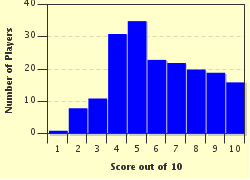
Score Distribution

quiz
Quiz Answer Key and Fun Facts
1. The PCT starts at this small town, just east of San Diego in California. What is the name of the town where the trail starts?

Answer: Campo

The PCT (The Pacific Crest Trail) starts just a few feet from the Mexican border in California. You can see the border wall just behind me.

The monument is the start of the 2,665 mile trail that travels from California, through Oregon and up to Washington, to the border of Canada.

I actually only hiked close to three sections of the trail, up to mile marker 266. It took me twenty days to hike these sections.
2. You travel up and down thousands of feet of elevation, up and down mountains. The first major mountain that I crossed was just west of Palm Springs. It's the highest peak in this range. What is the name of the mountain that I crossed first?

Answer: San Jacinto

The San Jacinto was my first major climb. The trail took me up 9000 feet of gain from the bottom, by Paradise Cafe (south side). I hiked up 5000 feet one day and camped at Apache Springs and hiked up the next 4000 feet the second day.

Some people hike off trail to the San Jacinto Peak, which is at 10,834 feet, but I stayed on course.

While I camped at the Apache Spring area, I overlooked Palm Springs! It was absolutely breath taking.

The picture here shows San Jacinto Mountain and I camped just to the left of the peak (highest point).
3. Many PCT hikers make a quick stop at this town, known for its Apple Festival. What is the name of this historic town?

Answer: Julian

I caught a ride to Julian from the PCT, Scissors Crossing area. As a PCT hiker, the locals know that you'll be hitchhiking to the close towns to resupply and get an occasional shower. I was actually on the trail for six days before getting a room and much needed shower in Julian.

Julian is famous for apples and apple pies. I went to Mom's Pies and had a piece of apple pie a la mode! It was the best after so many days of dried rice and soup for dinners.
4. After hiking up and down 9000 feet of elevation, I had to do it again to climb this mountain. What mountain is the highest point in the San Bernadino Mountain range?

Answer: San Gorgonio

San Gorgonio is the highest point in this range at 11,502 feet. The other peaks are in the same area, just lower elevation. The PCT trail is about ten miles away from the San Gorgonio Peak. Many people drop and hide their packs and 'bag' the peak. I decided not to attempt the peak because there was still so much snow in April 2013.

I can always come back and 'bag' the peak and sign the register at the peak at another time. At most peaks, there will be a box. We call it a sign in box, a register or summit box. You sign a note, your name or anything in the box to let people know that you were there.
5. I started my journey at mile marker zero of the PCT and finished at mile marker 266. I stopped outside of a city that has a major ski resort. There is the 'city' and the 'lake'. Which city did I stop hiking at?

Answer: Big Bear

I saw many animals along the trail. Lizards, snakes, dogs, cats, turtles and yes, even a bear. This bear was located at a person's home. It was a private zoo along the trail. There was also a tiger caged up there too.

I finished my trail at Big Bear City. You had to drive through the city to get to Big Bear Lake. I had mailed myself a package to the hotel with all my clean clothing. The problem was, after hiking for twenty days, I lost 13 pounds and the pants were way too big! Not a bad problem to have.
6. A couple of times I ran into a few plants that were poisonous. This 'bush' had purple flowers and was named after a dog. What was the name of this bush that gives you a rash?

Answer: Poodle-Dog Bush

You needed to really avoid touching this bush. It could cause just a mild rash or something more severe which may blister your skin for up to two weeks.

It was quite popular in a few areas on the trail. I was very cautious to stay away! They recommend that you wear long pants through the area but when it's so hot, it's difficult to wear long pants.
7. There were many times where you needed to fill up your water bladder or bottles. One way was to get it from a stream of water. Another way was "Trail Angels" leaving water on the trail. What was this called when we found water on the trail, like this picture?

Answer: Cache water

This one spot in particular was an absolute God-send to me. I had been hiking for close to 17 miles that day and knew that I was coming up to this area. I was thrilled to see that someone was so kind to leave so much water for the hikers.

There was a log book to write down how much water you had taken and any other notes you may leave. If you get to this spot, look for my notes - Hollandaise! I was extremely thankful!
8. I saw lots of wild life, but I heard a little 'gobble' and looked down and saw these tracks. What animal is walking about twenty feet in front of me?

Answer: Turkey

I had to laugh because I heard this 'gobble gobble'. I looked around and then I looked down and saw these tracks. Up ahead of me, on the trail, was this turkey just walking along. I followed him for about 100 feet or so. Amazing that he wasn't too scared of me.
9. This rock was about five miles outside of Warner Springs. You needed to walk across this beautiful meadow to get here. What is the name of this rock?

Answer: Eagle Rock

This is a very easy hike in the Warner Springs area. You can actually park and walk about five miles to see the rock and hike back to the car. It's well worth the walk. I never did find out if this was man made or not.
10. I really enjoyed my backpacking trip going along the PCT. I learned many things and met many wonderful people along the way. I had hiked 266 miles, from Campo, California to Big Bear City, California. I took twenty days and only one zero day in Idyllwild (resting my feet). So many people think they know what PCT stands for. Do you know?

Answer: Pacific Crest Trail

The biggest mistake people make is the Pacific Coast. Nope, it's 'Crest'. You will see the PCT emblem or markings all along the trail. As I came down off the San Jacinto Mountains, I saw the PCT marked on the road. I had to walk along the road for about a mile and then headed back on the dirt again.

I will never forget that journey and I look forward to doing close to 300 miles each year until I complete the entire trail in about 10 years.

I encourage everyone to don a backpack and get out and enjoy nature! I hope you enjoyed the quiz as much as I enjoyed reliving it with you.
Source: Author linkan

This quiz was reviewed by FunTrivia editor Tizzabelle before going online.
Any errors found in FunTrivia content are routinely corrected through our feedback system.
1/21/2025, Copyright 2025 FunTrivia, Inc. - Report an Error / Contact Us