FREE! Click here to Join FunTrivia. Thousands of games, quizzes, and lots more!
Quiz about And We Never Saw It AgainEver

And We Never Saw It Again...Ever! Quiz


During early sea exploration, map-making was a very inexact science. Many maps included islands that simply didn't exist. These are some of those phantom islands.

A multiple-choice quiz by illiniman14. Estimated time: 6 mins.
  1. Home
  2. »
  3. Quizzes
  4. »
  5. Geography Trivia
  6. »
  7. Physical Geography
  8. »
  9. Islands

Author
illiniman14
Time
6 mins
Type
Multiple Choice
Quiz #
322,882
Updated
Dec 03 21
# Qns
10
Difficulty
Tough
Avg Score
6 / 10
Plays
2521
Awards
Editor's Choice
Last 3 plays: DarkeScampus (7/10), blake_aus_nsw (8/10), patrickk (10/10).
- -
Question 1 of 10
1. Frisland (not to be confused with Friesland in the Netherlands) shows up on many maps of the North Atlantic Ocean before 1700. It first appeared on a falsified map by the Zeno family in Italy in 1558, and was wrongly included on maps after the fact. "Located" south of Iceland, which group of islands was Frisland most likely confused with? Hint


Question 2 of 10
2. In 1602, Father Antonio de la Ascension was traveling with a Spanish seafarer around North America, and he mentioned a great island off the coast of the continent separated by a great Mediterranean Sea. Despite land explorers' claims to the contrary, what future state was believed to be an island all of its own for over 100 years afterwards? Hint


Question 3 of 10
3. If you looked at Canadian maps from the 1500s, there was definitely one place you never wanted to go. The Isle of Demons was supposedly (and fittingly) populated by demons that attacked any ship nearby. This small "island" was situated off the coast of what much larger, real island? Hint


Question 4 of 10
4. According to Pliny the Elder, Xenophon (ca. 340-354 BCE) mentioned this island as being in Northern Europe. Historians have put it in Helgoland, Lithuania (the coast), Zealand, or Scandinavia, but we may never know. What mythical place is this, perhaps most famous for possibly being the origin for the name of a European sea? Hint


Question 5 of 10
5. Some myths are so ingrained into popular belief that they try to make a mockery of history. The Isles Phelipeaux and Pontchartrain were believed to exist in the middle of Lake Superior. One treaty used Isle Phelipeaux to define the border between the United States and Canada. Which war did this treaty end? Hint


Question 6 of 10
6. In the early 1800s, American Benjamin Morrell decided to explore around Antarctica. He found New South Greenland while trying to navigate the icy waters, but nearly 90 years later his findings were completely disproven when German Wilhelm Filchner found that the sea depth of the area was over 5,000 feet. In what icy sea was New South Greenland supposed to reside? Hint


Question 7 of 10
7. In 1906, Robert Peary witnessed a mirage in northern Nunavut, Canada, and named it Crocker Land. Donald MacMillan was also on that expedition, and in 1913 he decided to actually go out and land on the island. It was obviously not found, and the captain ran the ship aground after getting drunk. Stranded, most of the Crocker Land Expedition was forced to stay in Northern Greenland for how long? Hint


Question 8 of 10
8. When Marco Polo returned from his travels in Asia in 1292, he told a story of the largest island in the world, which he called La grande isle de Java ("The great island of Java"), or simply Jave la Grande. Java Minor has been supposed to be Java, Sumatra, or Simbawa, but Jave la Grande was seen as part of another fictional massive southern continent, known at that time by what name? Hint


Question 9 of 10
9. Europeans during the 16th and 17th centuries simply could not explain why their compasses only pointed north. The assumption was made that a massive magnetic island was situated at the North Pole, drawing needles in that direction. What was the name of this island, which Gerardus Mercator himself estimated to have a circumference of "almost 33 French miles"? Hint


Question 10 of 10
10. Not technically a phantom island, San Serriffe was supposed to be located near Tenerife in the Atlantic Ocean before it was purposely moved near the Seychelles in the Indian Ocean. Its first mention was in 1977 as part of an elaborate April Fools' Day hoax by what British newspaper? Hint


(Optional) Create a Free FunTrivia ID to save the points you are about to earn:

arrow Select a User ID:
arrow Choose a Password:
arrow Your Email:


Most Recent Scores
Oct 20 2024 : DarkeScampus: 7/10
Oct 16 2024 : blake_aus_nsw: 8/10
Sep 24 2024 : patrickk: 10/10

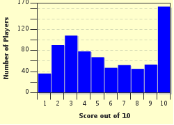
Score Distribution

quiz
Quiz Answer Key and Fun Facts
1. Frisland (not to be confused with Friesland in the Netherlands) shows up on many maps of the North Atlantic Ocean before 1700. It first appeared on a falsified map by the Zeno family in Italy in 1558, and was wrongly included on maps after the fact. "Located" south of Iceland, which group of islands was Frisland most likely confused with?

Answer: Faroe Islands

Nicoló Zeno claimed to have found a map from two Zeno brothers in the 1390s. The brothers had apparently stopped on Frisland while traveling in the North Atlantic. However, this note is somewhat glossed over as Nicoló also claimed that the brothers found the Americas on this voyage, some 100 years before Christopher Columbus. The vast majority of historians take the Zeno map as a hoax and nothing more.

Frisland itself was supposedly south of Iceland, and while mapmakers may have confused its legend with the Faroe Islands, both appear on many maps very distinctly. Confusion undoubtedly hurt the situation, as many sailors were led to believe that Frisland actually existed, so if they saw southern portions of Iceland or Greenland off in the distance, some accepted what they saw as the imaginary island.
2. In 1602, Father Antonio de la Ascension was traveling with a Spanish seafarer around North America, and he mentioned a great island off the coast of the continent separated by a great Mediterranean Sea. Despite land explorers' claims to the contrary, what future state was believed to be an island all of its own for over 100 years afterwards?

Answer: California

Regardless of what led Father de la Ascension to believe California was its own island, cartographers decided to take his word for it. Maps were released showing the state not so much an island off by itself, but rather separated from the rest of North America by a strait, while the east coast of California and west coast of North America retained remarkably little detail. One map made around 1650 curiously listed San Francisco as residing on both the west coast of the continent and the west coast of California.

It is believed today that the confusion was caused by the Gulf of California, and the assumption by early seafarers that it continued up through the continent.
3. If you looked at Canadian maps from the 1500s, there was definitely one place you never wanted to go. The Isle of Demons was supposedly (and fittingly) populated by demons that attacked any ship nearby. This small "island" was situated off the coast of what much larger, real island?

Answer: Newfoundland

The Isle of Devils is thought to be the real Quirpon Island, which by all accounts has no demons ready to torment ships or anyone who sets foot on the island. One legend about the island was that a captain's niece on a French ship fell in love with an officer and became pregnant, so the captain stranded them there.

While on the island, the lovers were tormented by the demons. In some versions, they were accompanied by an old nurse and eventually only the young woman survived as she was picked up by a ship later.

In other accounts, the couple was seemingly never heard from again, though modern residents claim they have seen the couple wandering the area waiting for their rescue that will never come. A true phantom story indeed.
4. According to Pliny the Elder, Xenophon (ca. 340-354 BCE) mentioned this island as being in Northern Europe. Historians have put it in Helgoland, Lithuania (the coast), Zealand, or Scandinavia, but we may never know. What mythical place is this, perhaps most famous for possibly being the origin for the name of a European sea?

Answer: Baltia

Not much is known about Baltia (also Balcia or Basilia), other than Pliny the Elder's accounts. According to him, a great amount of amber was thrown upon the shore during the spring. Also, it was supposed to be a three-day sail from Scythia, despite Scythia being landlocked on its northern border.

However, it may very well be the origin of the name for the Baltic Sea, where the island was supposed to exist.
5. Some myths are so ingrained into popular belief that they try to make a mockery of history. The Isles Phelipeaux and Pontchartrain were believed to exist in the middle of Lake Superior. One treaty used Isle Phelipeaux to define the border between the United States and Canada. Which war did this treaty end?

Answer: American Revolution

The Treaty of Paris that ended the American Revolution defined part of the border of the United States and Canada as "thence through Lake Superior northward of the Isles Royal and Phelipeaux to the Long Lake". This mistake was caused because the map used for the Treaty of Paris was the Mitchell Map, created by a non-cartographer who put a rather large Isle 'Philippeaux' right in the middle of Lake Superior.

It was not until the 1820s when surveyors realized that not only did neither island exist, but the "Long Lake" mentioned alongside the isle that was supposed to be due west of it also was not there.
6. In the early 1800s, American Benjamin Morrell decided to explore around Antarctica. He found New South Greenland while trying to navigate the icy waters, but nearly 90 years later his findings were completely disproven when German Wilhelm Filchner found that the sea depth of the area was over 5,000 feet. In what icy sea was New South Greenland supposed to reside?

Answer: Weddell Sea

Benjamin Morrell supposedly found "Morrell's Land" in 1823, also known as New South Greenland. However, Morrell had a very bad reputation and few sailors who knew him believed his fantastic story of a large island right next to Antarctica. In 1838, Jules Dumont d'Urville sailed through what should have been the northern portion of the island, and most dismissed Morrell.

In 1843, another explorer claimed a land sighting near where New South Greenland would be, but in 1912 Filchner ended all rumors that it existed.
7. In 1906, Robert Peary witnessed a mirage in northern Nunavut, Canada, and named it Crocker Land. Donald MacMillan was also on that expedition, and in 1913 he decided to actually go out and land on the island. It was obviously not found, and the captain ran the ship aground after getting drunk. Stranded, most of the Crocker Land Expedition was forced to stay in Northern Greenland for how long?

Answer: 4 years

Launched in July 1913, the Crocker Land Expedition was doomed from the very start, and it ended up being quite a disaster. MacMillan tried to lead a team from Northern Greenland over the Arctic ice for over 1,000 miles to reach the mythical Crocker Land. Several members turned back and the rest barely made it back to solid ground before the ice broke up at the end of the season. Trying to get back to camp, MacMillan had Fitzhugh Green and an Inuit guide, Piugaattoq (who knew from the start that Crocker Land was simply an illusion), scout a way back. After being stranded in a cave during a blizzard, Green shot Piugaattoq.

In December 1914, MacMillan and Maurice Tanquary tried to get to Etah, Greenland, to send a message to get a rescue. MacMillan was forced to return and Tanquary made it to Etah several months later. Two rescue ships both failed to make it to the group, with the first being stranded for two years in the ice. Three members had already made it back to the United States by the time Robert Bartlett finally arrived to save the rest of the team in 1917.
8. When Marco Polo returned from his travels in Asia in 1292, he told a story of the largest island in the world, which he called La grande isle de Java ("The great island of Java"), or simply Jave la Grande. Java Minor has been supposed to be Java, Sumatra, or Simbawa, but Jave la Grande was seen as part of another fictional massive southern continent, known at that time by what name?

Answer: Terra Australis

It is unclear what Marco Polo was referring to when he mentioned Jave la Grande, but speculation has come up that he meant Australia itself, however unlikely it may seem. Since it may never be known, historians have somewhat ignored the claim of Jave la Grande as nothing more than speculation on the hypothetical Terra Australis.

Some Europeans surmised that there was a massive southern continent essentially stretching from Australia to Antarctica, and that Jave la Grande was either just off of the coast or an extension of the continent.
9. Europeans during the 16th and 17th centuries simply could not explain why their compasses only pointed north. The assumption was made that a massive magnetic island was situated at the North Pole, drawing needles in that direction. What was the name of this island, which Gerardus Mercator himself estimated to have a circumference of "almost 33 French miles"?

Answer: Rupes Nigra

First mentioned in "Inventio Fortunata," Rupes Nigra (meaning "Black Rock") was described by Mercator as an island "almost 33 French miles, and it is all of magnetic stone". Of course, he also described the island as being in the middle of a whirlpool surrounded by four countries separated by four rivers that flow into the whirlpool.

The island was included on many maps to explain the northern reaches of the globe, but once explorers got to the region they realized that this description was completely inaccurate.
10. Not technically a phantom island, San Serriffe was supposed to be located near Tenerife in the Atlantic Ocean before it was purposely moved near the Seychelles in the Indian Ocean. Its first mention was in 1977 as part of an elaborate April Fools' Day hoax by what British newspaper?

Answer: The Guardian

"The Guardian" newspaper originally only planned on doing a one-page hoax story on the fictional San Serriffe (a play on sans-serif, a typology term of letters without small features on each letter). It, however, played the story up in a huge seven-page supplement to draw interest.

It was also reused several times since then by the paper for other hoaxes. The reason the decision was made to change the location of the fictional island was due to the Tenerife disaster on March 27, where two Boeing 747s collided with each other at Los Rodeos Airport.

Not wanting to put more attention on the area with a hoax, San Serriffe was moved to near the Seychelles, over 5,000 miles away.
Source: Author illiniman14

This quiz was reviewed by FunTrivia editor Pagiedamon before going online.
Any errors found in FunTrivia content are routinely corrected through our feedback system.
11/5/2024, Copyright 2024 FunTrivia, Inc. - Report an Error / Contact Us