FREE! Click here to Join FunTrivia. Thousands of games, quizzes, and lots more!
Quiz about Capital Places

Capital Places Trivia Quiz


With the geographical information supplied (including latitude and longitude), supplemented with a bit of history, you should be able to locate many if not all of these capital cities.

A multiple-choice quiz by uglybird. Estimated time: 6 mins.
  1. Home
  2. »
  3. Quizzes
  4. »
  5. Geography Trivia
  6. »
  7. Historical Geography

Author
uglybird
Time
6 mins
Type
Multiple Choice
Quiz #
200,748
Updated
Dec 03 21
# Qns
10
Difficulty
Average
Avg Score
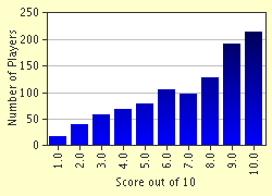
7 / 10
Plays
21178
Awards
Top 5% quiz!
Last 3 plays: Guest 24 (5/10), kitter96 (10/10), Guest 71 (7/10).
- -
Question 1 of 10
1. A Celtic tribe is believed to have founded this city on an island in the midst of a river in the latter part of the third century BC. In AD 508, a king named Clovis established the city as his capital and named it after the Celtic tribe. It is ideally situated to control trade on an important river. Its location is latitude 48.50 N, longitude 2.20 E. Of which nation is it the capital? Hint


Question 2 of 10
2. Believing they had subdued this land's Celtic tribes, the conquering Romans built the city that would become a provincial capital at a site ideal for trade. The Romans located their town on a river far enough inland to allow a bridge to be built across it, while still allowing easy access to the sea. The forces of a Celtic queen, Queen Boudica, destroyed the Roman settlement in AD 60, a mere ten years after it was built. The Romans rebuilt the city, which ultimately became the capital of the nation containing it. The city's location is latitude 51.36N, longitude 00.05W. It is the capital of which modern nation? Hint


Question 3 of 10
3. According to folklore, on April 21, 753 BC, twin brothers founded this city, locating it on the seven hills that lifted it above the surrounding (malarial?) swamps. Close to the Mediterranean, the location proved an ideal base for conquest. The city is located at latitude 41.54N, longitude 12.29E. Of which country is it the capital? Hint


Question 4 of 10
4. Settled as early as 5000 BC, this city's name probably means "foundation of peace". Located about 30 miles from the Mediterranean Sea, atop a limestone plateau 2500 feet above sea level, the steep ravines on three sides rendered the city immune to attack except from the north. Its mountainous terrain protected its Bronze Age people from the iron chariots of the more technologically advanced cities in the plain between the mountains and the sea. The king who conquered the city about 1000 BC made it the capital of his realm. The city's GPS coordinates are 31.47 N, 35.13 E. Of what nation is this city the capital? Hint


Question 5 of 10
5. An ancient people erected their "high city" upon an easily defensible, high, flat-topped hill. Appropriately, they named it after a deity who presided over both wisdom and warfare. Mountains surround the city on three sides; on the remaining side the city opens onto the Mediterranean Sea only five miles distant. Although defeated by another city-state in the fifth century BC, the city remained an intellectual and cultural center. It became its nation's capital in 1834. It is located at latitude 37.58 N, 23.46 E. Of which country is it the capital? Hint


Question 6 of 10
6. Ideally located for trade, this city was founded about 2000 BC. However, one of the region's most famous inhabitants lived nearby an estimated 500,000 years ago. The city is the terminus of the Grand Canal, which stretches for over 1000 miles and was built over 1000 years ago. The city's name means "northern capital", but the city once had a similar name that meant "northern peace". Its GPS coordinates are 39.55 N, 116.26 E. Of what nation is this city the capital? Hint


Question 7 of 10
7. In the ninth and tenth centuries AD, Celtic and Norwegian people settled in the area surrounding "Smoky Bay", so called because of the steamy mists that arose from nearby thermal springs. The city became its nation's capital when the country gained independence from a European power in 1944. Interestingly, this country has no armed forces. The city is located at latitude 64.10N, longitude 21.57W. Of what country is it the capital? Hint


Question 8 of 10
8. According to legend, Saint Andrew came to this remote area to preach, erected a cross on a hill, and predicted that some day a great city would arise here. In AD 482, according to this same legend, three brothers decided to found a city as they gazed at seven tree clad, wildflower strewn hills on the opposite side of a pristine, blue river. Each settled on one of the seven hills, and the city was named after one of the brothers. The steppes of this region were later home to the Cossacks. When the country gained its independence in 1991, this city became its capital. It is located at latitude 50.25 N, 30.3 E. Of which nation is this city the capital? Hint


Question 9 of 10
9. This city is believed to have been founded in the twelfth century AD as a village. Located on an estuary opening out onto a large bay, the city was also situated in one of the few level areas of this mountainous country. In the fifteenth century, a local ruler built a castle; and from 1603 to 1867 his descendants dominated the country, usurping the authority of the Emperor. Ironically, the city only became the capital in 1867 when the castle was surrendered to the Emperor. The GPS coordinates for this city are 35.40 N, 139.45 E. Of what country is it the capital? Hint


Question 10 of 10
10. This capital city is situated on a plateau over 7000 feet above sea level. A volcanic eruption destroyed the village that occupied the same location in 200 BC. In the fourteenth century AD, a city was constructed on an island in the middle of a lake. It became the capital of an empire that European invaders conquered in the sixteenth century. It is located at latitude 19.24 N, longitude 99.09 W. Of which nation is this city the capital? Hint


(Optional) Create a Free FunTrivia ID to save the points you are about to earn:

arrow Select a User ID:
arrow Choose a Password:
arrow Your Email:


Most Recent Scores
Nov 20 2024 : Guest 24: 5/10
Nov 15 2024 : kitter96: 10/10
Nov 12 2024 : Guest 71: 7/10
Nov 07 2024 : Guest 91: 8/10
Nov 07 2024 : Guest 128: 6/10
Oct 27 2024 : kented: 10/10
Oct 25 2024 : Guest 101: 6/10
Oct 18 2024 : haydenspapa: 4/10
Oct 17 2024 : Guest 37: 10/10

Score Distribution

quiz
Quiz Answer Key and Fun Facts
1. A Celtic tribe is believed to have founded this city on an island in the midst of a river in the latter part of the third century BC. In AD 508, a king named Clovis established the city as his capital and named it after the Celtic tribe. It is ideally situated to control trade on an important river. Its location is latitude 48.50 N, longitude 2.20 E. Of which nation is it the capital?

Answer: France

The Celtic Parisii built a village on an island (the Île de la Cité) in the Seine in the third century BC. At the time Julius Caesar conquered the city, it was known as Lutetia, which may have meant "mid-water dwelling". The Romans built a city on the Left Bank that became known as Civitas Parisorium and became the provincial capital. Barbarian incursions in the third century again confined the city to the island in the Seine.

When Clovis, King of the Franks, conquered the city in the sixth century AD, he made it his capital. Charlemagne's capital was Aachen; but when the Duke of Paris, Hugh Capet, became king in the tenth century, Paris again became the capital.
2. Believing they had subdued this land's Celtic tribes, the conquering Romans built the city that would become a provincial capital at a site ideal for trade. The Romans located their town on a river far enough inland to allow a bridge to be built across it, while still allowing easy access to the sea. The forces of a Celtic queen, Queen Boudica, destroyed the Roman settlement in AD 60, a mere ten years after it was built. The Romans rebuilt the city, which ultimately became the capital of the nation containing it. The city's location is latitude 51.36N, longitude 00.05W. It is the capital of which modern nation?

Answer: United Kingdom of Great Britain and Northern Ireland

Believing they had pacified the south of England, the Romans built Londinium about 50 AD, only to see Queen Boudica destroy it in an uprising in AD 60. The Romans rebuilt Londinium and ruled Britain for over 300 years.
3. According to folklore, on April 21, 753 BC, twin brothers founded this city, locating it on the seven hills that lifted it above the surrounding (malarial?) swamps. Close to the Mediterranean, the location proved an ideal base for conquest. The city is located at latitude 41.54N, longitude 12.29E. Of which country is it the capital?

Answer: Italy

According to legend, Romulus and Remus founded Rome. Unlike many such legendary events, Roman historians fixed an exact date for this one. In 2004 scientists obtained DNA evidence indicating the presence of a deadly form of malaria in fifth century AD Rome. Malaria can now be added to such factors as lead in the drinking water and impaired food supplies as contributors to the fall of Rome.
4. Settled as early as 5000 BC, this city's name probably means "foundation of peace". Located about 30 miles from the Mediterranean Sea, atop a limestone plateau 2500 feet above sea level, the steep ravines on three sides rendered the city immune to attack except from the north. Its mountainous terrain protected its Bronze Age people from the iron chariots of the more technologically advanced cities in the plain between the mountains and the sea. The king who conquered the city about 1000 BC made it the capital of his realm. The city's GPS coordinates are 31.47 N, 35.13 E. Of what nation is this city the capital?

Answer: Israel

Biblical accounts indicate that King David captured Jerusalem, making it the capital of his kingdom, in the eleventh century BC. Egyptian references to the city date to 1900 BC. By the time the Roman general Titus took the city in AD 70, a wall over 100 feet high protected the northern approach to the city. Titus remarked that his capture of the city would have been impossible had there not been dissension behind its walls.

Israel declared Jerusalem to be its capital in 1950. The Knesset confirmed this in 1980, proclaiming: "Jerusalem, complete and united, is the capital of Israel."
5. An ancient people erected their "high city" upon an easily defensible, high, flat-topped hill. Appropriately, they named it after a deity who presided over both wisdom and warfare. Mountains surround the city on three sides; on the remaining side the city opens onto the Mediterranean Sea only five miles distant. Although defeated by another city-state in the fifth century BC, the city remained an intellectual and cultural center. It became its nation's capital in 1834. It is located at latitude 37.58 N, 23.46 E. Of which country is it the capital?

Answer: Greece

The name for the famous Athenian hill on which the Parthenon stands, the Acropolis, means literally "high city". Greeks migrating into the Attic peninsula probably occupied the area about 1900 BC. By the middle of the fifth century BC, Athens had entered her golden age.

However, in the final decades of the century, Spartan forces overcame Athens. From this time, Athens remained a center of culture and learning but no longer played an important military role.
6. Ideally located for trade, this city was founded about 2000 BC. However, one of the region's most famous inhabitants lived nearby an estimated 500,000 years ago. The city is the terminus of the Grand Canal, which stretches for over 1000 miles and was built over 1000 years ago. The city's name means "northern capital", but the city once had a similar name that meant "northern peace". Its GPS coordinates are 39.55 N, 116.26 E. Of what nation is this city the capital?

Answer: China

"Peking man", also denoted "Homo erectus", referred to the discovery of human remains, including a skullcap, southwest of Beijing in 1923. Ages from 200,000 to 700,000 years have been suggested for the remains. In the thirteenth century AD, Kublai Khan rebuilt Beijing, which Genghis Khan had devastated. Kublai made the city his capital. "Beijing" was formerly spelled "Peking". During the brief period of time when it was "Beiping" it was the "northern "peace".
7. In the ninth and tenth centuries AD, Celtic and Norwegian people settled in the area surrounding "Smoky Bay", so called because of the steamy mists that arose from nearby thermal springs. The city became its nation's capital when the country gained independence from a European power in 1944. Interestingly, this country has no armed forces. The city is located at latitude 64.10N, longitude 21.57W. Of what country is it the capital?

Answer: Iceland

Reykjavik means "Smoky Bay". Vikings with their Irish and Scottish slaves began settling there in the ninth century AD. In the tenth century, the Althing, considered to be Europe's oldest representative assembly, began meeting. Despite this, Iceland did not become a fully independent state until 1944 when it declared its independence from Denmark.
8. According to legend, Saint Andrew came to this remote area to preach, erected a cross on a hill, and predicted that some day a great city would arise here. In AD 482, according to this same legend, three brothers decided to found a city as they gazed at seven tree clad, wildflower strewn hills on the opposite side of a pristine, blue river. Each settled on one of the seven hills, and the city was named after one of the brothers. The steppes of this region were later home to the Cossacks. When the country gained its independence in 1991, this city became its capital. It is located at latitude 50.25 N, 30.3 E. Of which nation is this city the capital?

Answer: Ukraine

The Scandinavian Rus, Russia, Poland, the Ottoman Empire and the USSR have controlled the region that is now the Ukraine (and its capital, Kiev) over the centuries. Looked at another way, the Kievian Rus founded not only the Ukraine but also Russia and Belarus.
9. This city is believed to have been founded in the twelfth century AD as a village. Located on an estuary opening out onto a large bay, the city was also situated in one of the few level areas of this mountainous country. In the fifteenth century, a local ruler built a castle; and from 1603 to 1867 his descendants dominated the country, usurping the authority of the Emperor. Ironically, the city only became the capital in 1867 when the castle was surrendered to the Emperor. The GPS coordinates for this city are 35.40 N, 139.45 E. Of what country is it the capital?

Answer: Japan

Established in the twelfth century AD, the village of Edo became Tokyo. In 1603, Tokugawa Ieyasu became the military ruler (Shogun) of Japan. His descendants were the de facto rulers of Japan, holding the office of Shogun as an hereditary title until 1867. In 1867, the Emperor reasserted his authority, moved into Edo Castle, and Edo became the capital of Japan.
10. This capital city is situated on a plateau over 7000 feet above sea level. A volcanic eruption destroyed the village that occupied the same location in 200 BC. In the fourteenth century AD, a city was constructed on an island in the middle of a lake. It became the capital of an empire that European invaders conquered in the sixteenth century. It is located at latitude 19.24 N, longitude 99.09 W. Of which nation is this city the capital?

Answer: Mexico

The Aztecs built their city of Tenochtitlan on an island in the midst of Lake Texcoco. The city connected to the mainland over a series of elevated ramps. The Spanish built Mexico City on top of the ruins of the city they destroyed. Mexico sits atop extremely active tectonic plates. An earthquake that killed thousands in Mexico City in 1985 centered over 100 miles away but measured 8.1 on the Richter scale.
Source: Author uglybird

This quiz was reviewed by FunTrivia editor LilahDeDah before going online.
Any errors found in FunTrivia content are routinely corrected through our feedback system.
11/21/2024, Copyright 2024 FunTrivia, Inc. - Report an Error / Contact Us