FREE! Click here to Join FunTrivia. Thousands of games, quizzes, and lots more!
Quiz about Cross Canada Trip the First Leg

Cross Canada Trip, the First Leg Quiz


Thus begins our epic journey, starting from the easternmost point of North America. The first leg of our journey starts with the province of Newfoundland and Labrador! Buckle up, 'cause we are hitting the road!

A photo quiz by reedy. Estimated time: 5 mins.
  1. Home
  2. »
  3. Quizzes
  4. »
  5. Geography Trivia
  6. »
  7. Canada
  8. »
  9. Newfoundland

Author
reedy
Time
5 mins
Type
Photo Quiz
Quiz #
404,614
Updated
Dec 03 21
# Qns
10
Difficulty
Average
Avg Score
7 / 10
Plays
344
Awards
Top 20% Quiz
Last 3 plays: tomwing (5/10), Dagny1 (10/10), portalrules123 (5/10).
-
Question 1 of 10
1. We begin our trip at the easternmost point of Newfoundland (and of Canada), where a lighthouse sits on the rocky shoreline at Cape Spear. What was the name given to this site by early Portuguese explorers, which translates as 'Cape of Hope'? Hint


Question 2 of 10
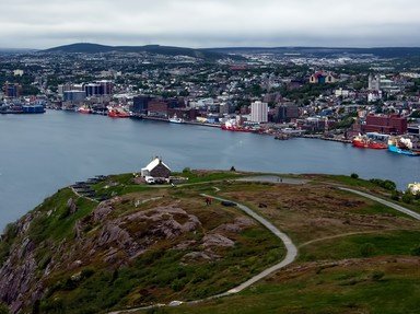
2. A 20-minute drive from Cape Spear will bring you to Signal Hill, where the world's first transatlantic wireless signal was received by Guglielmo Marconi in 1901. Cabot Tower, pictured here, began construction in 1897 to commemorate the 400th Anniversary of Cabot's "Voyage of Discovery", as well as for what other event? Hint


Question 3 of 10
3. In 1583, Sir Gilbert Humphrey arrived in St. John's Harbour and laid claim to the land for England under a Royal Charter. This was the first colonial claim of what would become the British Empire. Who was the monarch at the time? Hint


Question 4 of 10
4. Leaving St. John's, it is a little bit more than a three hour northerly drive to find the North Atlantic Aviation Museum on the Trans Canada Highway. In what town, that gained international fame during the 9/11 crisis when many airplanes were diverted there, can it be found? Hint


Question 5 of 10
5. In 1878, a record-setting giant squid was found and captured on the shore of what is today known as Glover's Harbour (on the northern coast). At the time, however, the fishing village had not yet been established. What was the region (and the specimen) originally called, funnily enough? Hint


Question 6 of 10
6. From Glover's Harbour it takes nearly four hours of driving to reach Corner Brook on Newfoundland's west coast. Looking out over the Bay of Islands stands a statue of which explorer, who mapped the coastline of the entire island in the 1760s? Hint


Question 7 of 10
7. Turning north and just an hour's drive away from Corner Brook is Gros Morne National Park. This breathtaking region takes its name from the island's second-highest peak (807 m). What is the most literal translation of 'Gros Morne'? Hint


Question 8 of 10
8. Continuing nearly 400 km north to the tip of the Great Northern Peninsula we find L'Anse aux Meadows National Historic Site. Dating from approximately 1,000 CE, the buildings discovered here (in the 1960s) have been authenticated as being Norse in origin.


Question 9 of 10
9. Approximately 75 km due north of L'Anse aux Meadows lies a small island off the east coast of Labrador. Battle Harbour (on Battle Island) became the capital and largest community in Labrador, primarily due to what industry? Hint


Question 10 of 10
10. After catching the ferry back to Newfoundland, a six-hour drive will bring you to Port aux Basques in the southwest corner of the island and another ferry that will take you to Nova Scotia. Depending on weather, how long does it take for the ferry to reach North Sydney, NS? Hint


(Optional) Create a Free FunTrivia ID to save the points you are about to earn:

arrow Select a User ID:
arrow Choose a Password:
arrow Your Email:


View Image Attributions for This Quiz

Most Recent Scores
Dec 14 2024 : tomwing: 5/10
Dec 08 2024 : Dagny1: 10/10
Dec 05 2024 : portalrules123: 5/10

Quiz Answer Key and Fun Facts
1. We begin our trip at the easternmost point of Newfoundland (and of Canada), where a lighthouse sits on the rocky shoreline at Cape Spear. What was the name given to this site by early Portuguese explorers, which translates as 'Cape of Hope'?

Answer: Cabo da esperança

While the island of Newfoundland was eventually claimed by the British, it was Portuguese sailors that were among the first Europeans to explore the region. Some records indicate that they might have been there before Columbus' infamous voyage to the New World in 1492, and prior to Giovanni Caboto's (John Cabot's) landing in Newfoundland in 1497, but this has not been proven beyond a reasonable doubt.

While the Portuguese did sail Newfoundland's waters and set foot on the island, it was deemed too cold for their liking, and they decided to pursue lands in warmer climes.

Today, Cape Spear marks the easternmost point of Newfoundland, of Canada, and of North America (if you don't take Greenland into consideration).
2. A 20-minute drive from Cape Spear will bring you to Signal Hill, where the world's first transatlantic wireless signal was received by Guglielmo Marconi in 1901. Cabot Tower, pictured here, began construction in 1897 to commemorate the 400th Anniversary of Cabot's "Voyage of Discovery", as well as for what other event?

Answer: Queen Victoria's Diamond Jubilee

There is no solid evidence of where John Cabot actually made landfall during his second voyage in 1497 (his first was a failure), but the latitudes recorded on the voyage suggest that he landed in Labrador, then sailed along the the northern part of Newfoundland as far as the (present day) Avalon Peninsula before returning to England.

The year 1897 also marked the 60th anniversary of Queen Victoria's ascent to the throne. Thus, the Cabot Tower, built in the fortifications of the already-existing citadel guarding the entrance to St. John's Harbour. Construction was completed in 1900, and the location was declared a Canadian National Historic Site in 1951.
3. In 1583, Sir Gilbert Humphrey arrived in St. John's Harbour and laid claim to the land for England under a Royal Charter. This was the first colonial claim of what would become the British Empire. Who was the monarch at the time?

Answer: Elizabeth I

Sir Gilbert Humphrey was a prominent Englishman whose efforts at exploration on behalf of the Crown set the tone for what would follow - the eventual British Empire. When he came to Newfoundland in August of 1583 to lay a land claim for England, there was already a vibrant fishing industry in place, comprised of enterprising people from many countries. Humphrey claimed a large parcel of land (and the Grand Banks) for the Queen, and even began taxing the men working the fishing stations.

But, he didn't actually stick around to solidify the claim, and on the return voyage to England a few weeks later, he died when his ship foundered in a storm. It wasn't until 1610 that the claim would be formalized with the establishment of a permanent English colony. Everything prior had just been seasonal settlements for fishing.

St. John's is located at the northeastern point of the Avalon Peninsula, which itself extends from the southeast portion of the main island.
4. Leaving St. John's, it is a little bit more than a three hour northerly drive to find the North Atlantic Aviation Museum on the Trans Canada Highway. In what town, that gained international fame during the 9/11 crisis when many airplanes were diverted there, can it be found?

Answer: Gander

The town of Gander is in the northeast quadrant of Newfoundland, about 40 km south of the north coast of the island (at Gander Bay). In 1935 it was decided to build an airport at the site, and the town was born as construction began. It also became the site for thousands of military personnel during World War II. Originally, the airport was dubbed 'The Newfoundland Airport', but since 1949 (when Newfoundland joined Confederation) it has been called 'Gander International Airport'.

As a town founded because of the aviation industry, it became the natural choice for the location of the North Atlantic Aviation Museum, which was opened in 1996.
5. In 1878, a record-setting giant squid was found and captured on the shore of what is today known as Glover's Harbour (on the northern coast). At the time, however, the fishing village had not yet been established. What was the region (and the specimen) originally called, funnily enough?

Answer: Thimble Tickle

Glover's Harbour is approximately 140 km northwest of Gander, by way of a detour off of the Trans Canada Highway (turn right at Bishop's Falls). The area on the coast at Notre Dame Bay was originally called 'Thimble Tickle', which isn't as silly as it sounds. A 'tickle' is just a narrow strait, and there are a number of tickles to be found along Newfoundland's jagged coastline.

When the giant squid (the 'Thimble Tickle specimen') was found at Thimble Tickle in 1878, the men who found it ended up butchering it for dog food, and no actual documentation or photographs exist to confirm the claims of its size. The Guinness record was granted based on eyewitness accounts (and estimates).

The statue at Glover's Harbour is supposed to be 'life-size', according to the reported measurements (6.1 m from beak to tail, with a total length of 16.8 m with the tentacles).
6. From Glover's Harbour it takes nearly four hours of driving to reach Corner Brook on Newfoundland's west coast. Looking out over the Bay of Islands stands a statue of which explorer, who mapped the coastline of the entire island in the 1760s?

Answer: James Cook

It was in the years following the English victory at the Plains of Abraham that James Cook, given his first command (of the HMS Grenville), was tasked to map the coasts of Newfoundland and Labrador. This was done over five seasons between 1763 and 1767. Such was the accuracy of his work that his maps were used (or referenced) for the next two centuries.

While any location could have been chosen to play host to such a site, the Captain James Cook National Historic Site was established in the city of Corner Brook largely due to the efforts of Mayor (Dr.) Noel Murphy in the 1970s, who originally placed plaques at the location where a statue stands today. The statue, depicting a younger James Cook holding a quadrant, was sculpted by Newfoundlander (by way of immigration) Luben Boykov.
7. Turning north and just an hour's drive away from Corner Brook is Gros Morne National Park. This breathtaking region takes its name from the island's second-highest peak (807 m). What is the most literal translation of 'Gros Morne'?

Answer: great sombre

Gros Morne Mountain (and Gros Morne National Park) can be found within the Long Range Mountains that extend along Newfoundland's west coast. Gros Morne is just five meters shy of the island's tallest mountain (The Cabox - 812 m), which is further south within the same range.

The national park was established in 1973, and was inscribed as a UNESCO World Heritage Site in 1987. As described on the UNESCO website, Gros Morne "provides a rare example of the process of continental drift, where deep ocean crust and the rocks of the earth's mantle lie exposed. More recent glacial action has resulted in some spectacular scenery, with coastal lowland, alpine plateau, fjords, glacial valleys, sheer cliffs, waterfalls and many pristine lakes."
8. Continuing nearly 400 km north to the tip of the Great Northern Peninsula we find L'Anse aux Meadows National Historic Site. Dating from approximately 1,000 CE, the buildings discovered here (in the 1960s) have been authenticated as being Norse in origin.

Answer: True

It was the husband and wife team of Helge (the explorer) and Anne Stine Ingstad (the archaeologist) who discovered that the locally known 'old Indian camp' mounds were, in fact, buried Norse structures. Over a number of years, eight buildings were painstakingly excavated, revealing a Norse settlement that matched those found in Greenland and Iceland from the same era.

Whether or not this was the same 'Vinland' named in the Norse sagas Leifsbudir (Leif Ericson) and Hóp (Norse Greenlanders) has not been proven, but the timeline is right, so the claim has been made.

The site was designated a National Historic Site of Canada in 1968, and was inscribed as a UNESCO World Heritage Site in 1978.
9. Approximately 75 km due north of L'Anse aux Meadows lies a small island off the east coast of Labrador. Battle Harbour (on Battle Island) became the capital and largest community in Labrador, primarily due to what industry?

Answer: Fishing

Battle Harbour may only be 75 km away from L'Anse aux Meadows, but getting there by car is a little more involved than going in a straight line. First, you have to backtrack 137 km to reach the ferry that crosses the Strait of Belle Isle from St. Barbe (Newfoundland) to Blanc Sablon (Québec). Then, it's another 166 km drive along the coast of Labrador until you reach Mary's Harbour and the ferry to Battle Harbour.

Battle Harbour was once the economic hub of Labrador, but in 1930 a major fire destroyed most of the community. It was completely abandoned in the 1960s, and what remained was given to the Battle Harbour Historic Trust. Many buildings were restored, and in 1996, the Battle Harbour Historic District National Historic Site of Canada was born.
10. After catching the ferry back to Newfoundland, a six-hour drive will bring you to Port aux Basques in the southwest corner of the island and another ferry that will take you to Nova Scotia. Depending on weather, how long does it take for the ferry to reach North Sydney, NS?

Answer: Five to seven hours

Apart from the many small ferries that will take you to the smaller islands around Newfoundland (including the French Territorial Collectivity of Saint-Pierre and Miquelon), there are only two ferry routes between Newfoundland and Nova Scotia.

The longer route goes between North Sydney (NS) and Argentia (NL), which is on the west coast of the Avalon Peninsula (just 133 km from St. John's). That route takes approximately 16 to 17 hours to complete. The shorter route is between Port aux Basques and North Sydney, with trips varying between five and seven hours in length (usually altered for convenient departure or arrival times).

The first ferry between the two provinces sailed in 1898.
Source: Author reedy

This quiz was reviewed by FunTrivia editor agony before going online.
Any errors found in FunTrivia content are routinely corrected through our feedback system.
Related Quizzes
This quiz is part of series Photographic Memory, Take 10:

My tenth set of ten photo quizzes on various topics, putting my photo quiz total at 100! Enjoy!

  1. Obsolete Jobs for Children Average
  2. All Things Green Easier
  3. Birds of a Feather? Average
  4. Jägerbombs Away! Easier
  5. All Things White Average
  6. Lions and Tigers and... Other Big Cats Average
  7. The Fine Line Between Yellow and Gold Average
  8. Cross Canada Trip, the First Leg Average
  9. Electromagnetic Attraction Average
  10. International Blue Average

Also part of quiz list
1/20/2025, Copyright 2025 FunTrivia, Inc. - Report an Error / Contact Us