FREE! Click here to Join FunTrivia. Thousands of games, quizzes, and lots more!
Quiz about Dawns Early Light

Dawn's Early Light Trivia Quiz

Kiribati

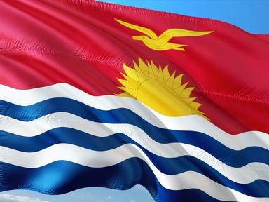
Kiribati claimed to be the first country to welcome the new millennium (and every other day since 1995) by the dawn's early light. (Clicking on the image to make it larger might help you work out some answers.)

A photo quiz by looney_tunes. Estimated time: 4 mins.
  1. Home
  2. »
  3. Quizzes
  4. »
  5. Geography Trivia
  6. »
  7. Pacific Islands
  8. »
  9. Kiribati

Author
looney_tunes
Time
4 mins
Type
Photo Quiz
Quiz #
339,348
Updated
Oct 23 24
# Qns
10
Difficulty
Average
Avg Score
7 / 10
Plays
4180
Awards
Top 5% quiz!
Last 3 plays: Guest 86 (3/10), MikeMaster99 (9/10), matthewpokemon (9/10).
-
Question 1 of 10
1. The name of the island country of Kiribati is pronounced as if the final 'ti' were an s, as is standard in the local language. This is an adaptation of the former name for which part of the country? Hint


Question 2 of 10
2. Now that you know how to pronounce its name, can you determine in which ocean the island nation of Kiribati can be found? Hint


Question 3 of 10
3. Kiribati is composed primarily of three island groups. Which of these is NOT one of them? Hint


Question 4 of 10
4. In 1995, Kiribati decreed that the International Date Line needed an extra zig, so that the entire country could be in the same day. As a result, one of its islands became one of the easternmost pieces of land on the western side of the Date Line. Which island has this honor? Hint


Question 5 of 10
5. Which of the following facts about Kiribati is true? Hint


Question 6 of 10
6. The flag of Kiribati shows a sun rising over wavy blue and white lines that represent the islands in the ocean. What kind of large seabird is also shown, representing the culture of the land? Hint


Question 7 of 10
7. At the start of the 21st century, Kiribati was one of the poorest and least-developed nations in the world. Its main export industry is copra. What is copra? Hint


Question 8 of 10
8. Kiritimati Island, also known as Christmas Island, has which of the following claims to fame? Hint


Question 9 of 10
9. Banaba, previously called Ocean Island, was almost completely mined out before Kiribati gained independence. What resource was virtually exhausted during the colonial era? Hint


Question 10 of 10
10. The country of Kiribati is under threat from global warming. The island of Banaba is the least likely to be inundated, as it contains the country's highest point. At the start of the 21st century, approximately how high above sea level was this highest point? Hint


(Optional) Create a Free FunTrivia ID to save the points you are about to earn:

arrow Select a User ID:
arrow Choose a Password:
arrow Your Email:


View Image Attributions for This Quiz

Most Recent Scores
Oct 24 2024 : Guest 86: 3/10
Oct 23 2024 : MikeMaster99: 9/10
Oct 23 2024 : matthewpokemon: 9/10
Oct 23 2024 : arscreens: 10/10
Oct 23 2024 : George95: 9/10
Oct 23 2024 : maninmidohio: 10/10
Oct 23 2024 : auto_enigma: 7/10
Oct 23 2024 : workisboring: 3/10
Oct 23 2024 : Guest 174: 10/10

Score Distribution

quiz
Quiz Answer Key and Fun Facts
1. The name of the island country of Kiribati is pronounced as if the final 'ti' were an s, as is standard in the local language. This is an adaptation of the former name for which part of the country?

Answer: Gilbert Islands

The Gilbert Islands include most of the inhabited islands of Kiribati including Tarawa, site of the national capital of South Tarawa. They were first reported by the English explorer Thomas Gilbert, and placed on a map by the German explorer Adam Johann Ritter von Krusenstern, who was leading a Russian round-the-world voyage from 1803 to 1806. The French explorer Louis Isidore Duperrey was the first to provide a complete and detailed map of the islands, which the locals called Tungaru.

When Kiribati gained independence in 1979, it was decided not to use the local name, since the new country included a number of islands that were not part of the Gilberts. The adaptation of the colonial name was intended to recognize the inclusion of these other islands in the new country.
2. Now that you know how to pronounce its name, can you determine in which ocean the island nation of Kiribati can be found?

Answer: Pacific Ocean

Kiribati stretches across a large part of the Pacific Ocean. Its western end is pretty much due north of New Zealand, while the eastern end is several thousand miles away, pretty much due south of Hawaii. The country's total land area of 717 sq km (277 sq mi) is spread over an expanse of ocean which is studded with islands belonging to other countries.

Kiribati has been inhabited since sometime around 3000 BCE by Micronesian settlers, whose language still forms the basis of the Gilbertese language. Later invasions, probably during the 14th century, by Polynesians and Melanesians introduced elements of their cultures and languages.
3. Kiribati is composed primarily of three island groups. Which of these is NOT one of them?

Answer: Ellice Islands

In 1892, the Gilbert Islands and the Ellice Islands became a British protectorate called (wait for it) the Gilbert and Ellice Islands. Eight of the eleven islands in the chain called the Line Islands were added in 1919, and the Phoenix Islands in 1937.

They gained self-rule in 1971, and independence in 1979, when the Ellice Islands were renamed Tuvalu, and the remaining portion adopted the name of Kiribati.
4. In 1995, Kiribati decreed that the International Date Line needed an extra zig, so that the entire country could be in the same day. As a result, one of its islands became one of the easternmost pieces of land on the western side of the Date Line. Which island has this honor?

Answer: Caroline Island

Technically, Caroline Island may not have been the first place to see the new millennium on January 1 (of 2000 or of 2001, let's not debate that issue here). There is a bit of Antarctica that actually received sunlight 35 minutes earlier, although there is some debate as to this, since it is so close to the Antarctic Circle that sunset and sunrise at that time of year sort of run into each other. Anyway, the tropical Caroline Atoll was a much better place to visit to be part of the celebrations, for which the island was renamed Millennium Island, a name which may or may not stick. Kiribati thus claims to have been the first inhabited country to enter the 21st century, although most of the population lies well to the west of other inhabited regions - New Zealand, for example, experienced the sunrise an hour ahead of Tarawa, because it was on Daylight Savings Time.

Caroline Island is a crescent-shaped coral atoll made up of 39 separate islets surrounding a narrow central lagoon. It is considered one of the Pacific atolls which has been least affected by human activity, and is an important breeding site for a number of species of sea birds, including the sooty tern. It is also the location of one of the world's largest populations of coconut crabs.
5. Which of the following facts about Kiribati is true?

Answer: Kiribati is the only country in the world that lies in all four global quadrants.

The Gilbert Islands are all located with East longitudes, while the Phoenix Islands and the Line Islands are on the other side of the 180th meridian, and are located with West longitudes. The equator runs through the middle of the country, with the Phoenix Islands lying completely in the southern hemisphere, and the other two groups spreading into both north and south. Kiribati is in both the East and West hemispheres, and in both the North and South hemispheres.

The world's largest country by land area is Russia (17,075,200 sq km), while the area of Kiribati places it at position 188 on a list (using figures from the CIA Factbook) that shows 239 countries, with the smallest being Vatican City (whose area is less than 1 sq km). The 32 coral atolls and single raised coral atoll which comprise Kiribati are definitely not volcanic in origin.
6. The flag of Kiribati shows a sun rising over wavy blue and white lines that represent the islands in the ocean. What kind of large seabird is also shown, representing the culture of the land?

Answer: Frigate bird

The rising sun is symbolic of Kiribati's location on the equator and on the 180th meridian. There are 17 rays, representing the 16 Gilbert Islands and Banaba. The three white wavy lines in the blue ocean remind viewers of the fact that there are three island groups included in the country. The frigate bird (in Gilbertese, te eitei) represents power and freedom, since it is renowned for spending over a week at a time in the air: because it cannot swim and walks with difficulty, it lands as little as possible.

The frigate bird is also included to signify the unique dance style of the I-Kiribati. Unlike most Pacific island dances, it is based on the use of outstretched arms, resembling a bird in flight, and jerky head movements, performed without smiling.
7. At the start of the 21st century, Kiribati was one of the poorest and least-developed nations in the world. Its main export industry is copra. What is copra?

Answer: Dried flesh from a coconut

Copra is dried coconut, prepared by splitting the coconuts in half, removing the husk, and allowing the flesh to dry in the sun. It is used as a source of coconut oil. Traditionally, coconut oil extraction involved grating the copra and boiling it in water. Now it is more commonly extracted using crushing machinery. Either process leaves behind a solid called coconut or copra meal.

This is high in protein, but has too much fibre to be convenient for large-scale human consumption, and is usually used as a livestock food supplement.
8. Kiritimati Island, also known as Christmas Island, has which of the following claims to fame?

Answer: It is the world's largest coral atoll in land area.

Remembering that 'ti' is pronounces as 's', you can see that Kiritimati is a direct rendition into Gilbertese of the European designation for this island. The tendency of explorers to name islands after the date on which they discovered them (if it seemed significant) has led to the existence of multiple islands called Christmas Island. For those of us living in Australia, the Christmas Island in the Indian Ocean which is an Australian territory springs more immediately to mind than does the one in Kiribati. With a land area of about 322 sq km (124 sq mi), over two-thirds of the land area of Kiribati, Kiritimati is the world's largest coral atoll by land area (although not by enclosed area). Since the exact land area is not constant on most coral atolls, and determining the land area is complicated by large expanses of salt flats, these rankings are not consistent among different authorities, and some sites do list either Lifou or Rennell Island as the largest coral atoll.

While a number of atmospheric nuclear tests were conducted on nearby Pacific atolls, Kirimati was not the site for the first of them. It definitely does not have any glaciers, and it does receive regular rainfall (unlike the Atacama Desert in Chile), although the porous soil and lack of vegetative cover mean that little is retained, and the climate is effectively arid, unusually so for a tropical island.
9. Banaba, previously called Ocean Island, was almost completely mined out before Kiribati gained independence. What resource was virtually exhausted during the colonial era?

Answer: Phosphates

Banaba is the only island of Kiribati which is not an atoll. It is described as a raised-coral island - as can be seen from the map, there is no lagoon. As is the case for most islands so described, it was a rich source of phosphate, primarily originating in its coral origins. Mining to produce fertilizer during the 20th century meant that almost 90% of the island's surface had been stripped before independence in 1979.

The approximately 300 inhabitants of the island at the start of the 21st century were opposed to the desire of the Kiribati government to reopen the phosphate mines.
10. The country of Kiribati is under threat from global warming. The island of Banaba is the least likely to be inundated, as it contains the country's highest point. At the start of the 21st century, approximately how high above sea level was this highest point?

Answer: 80 m (265 ft)

While rising sea levels pose a risk for all the island countries of the Pacific, Kiribati is one of those considered most at risk. Aside from the unnamed peak on Banaba, the entire country lies at an elevation under two metres (7 ft) above sea level. (As well as rising sea levels, these countries are threatened by tsunamis following earthquakes, since it doesn't take much to completely submerge them as the tsunami passes.) Not all authorities agree on this - aside from arguments as to whether global warming is real, it has been pointed out that the warmer waters increase coral growth rates, and some islands have actually increased in size over the last 50 years. Rising sea levels will, however, definitely cause increased salination, and this is a threat to the copra industry.
Source: Author looney_tunes

This quiz was reviewed by FunTrivia editor Pagiedamon before going online.
Any errors found in FunTrivia content are routinely corrected through our feedback system.
Related Quizzes
This quiz is part of series Written for the Bus Ride:

You think you can write just one, but it turns out that writing quizzes suitable for being visited by the tourists on the Bus Ride is addictive - there's just so much to find out!

  1. Saint Vincent and the Grenadines Average
  2. Barbados, Land of the Flying Fish Average
  3. Calypso Country - Trinidad and Tobago Average
  4. "The Land, the People, the Light" - Saint Lucia Average
  5. A Provincial Tour of Zimbabwe Average
  6. Republic of Benin, Formerly Dahomey Average
  7. The Landlocked Kingdom of Lesotho Average
  8. Honduras: "Free, Sovereign and Independent" Average
  9. Exploring Kosovo Average
  10. Democratic Republic of Sao Tome and Principe Average
  11. "We Stand With God" in Vanuatu Average
  12. They Came to Baghdad Average

11/21/2024, Copyright 2024 FunTrivia, Inc. - Report an Error / Contact Us