FREE! Click here to Join FunTrivia. Thousands of games, quizzes, and lots more!
Quiz about Roaming Around the Republic of Kiribati

Roaming Around the Republic of Kiribati Quiz


The Republic of Kiribati was formed in 1979, and, over time, three island groups - the Gilbert, Phoenix, and Line Islands - were united into one country. What do you know about the islands of the Republic of Kiribati?
This is a renovated/adopted version of an old quiz by author Vermic

A photo quiz by ponycargirl. Estimated time: 3 mins.
  1. Home
  2. »
  3. Quizzes
  4. »
  5. Geography Trivia
  6. »
  7. Pacific Islands
  8. »
  9. Kiribati

Author
ponycargirl
Time
3 mins
Type
Photo Quiz
Quiz #
28,452
Updated
Jul 22 22
# Qns
10
Difficulty
Average
Avg Score
8 / 10
Plays
178
Awards
Top 20% Quiz
Last 3 plays: redwaldo (10/10), Guest 98 (8/10), Guest 174 (7/10).
-
Question 1 of 10
1. Today the Republic of Kiribati consists of 33 islands. One of the islands is classified as a coral island. How are the other islands classified? Hint


Question 2 of 10
2. Many of the islands in the Republic of Kiribati are connected by raised roads, such as the Dai Nippon. What is the name for this type of raised road? Hint


Question 3 of 10
3. Which island in the Republic of Kiribati is a coral island? Hint


Question 4 of 10
4. What mineral ore, also found in Nauru, was discovered in the early 1900s in what became the Republic of Kiribati? Hint


Question 5 of 10
5. Before 1999 the Republic of Kiribati consisted of 35 islands. Two of the islands disappeared into the sea.


Question 6 of 10
6. Why was January 1, 1995, an important date in the Republic of Kiribati? Hint


Question 7 of 10
7. Which island in the Republic of Kiribati shares the same name with the country's capital, and was the site of a WWII battle? Hint


Question 8 of 10
8. As already stated, the Republic of Kiribati covers a huge area - 1.4 million square miles - in the Pacific Ocean. What term is used by geographers to describe the islands in the Pacific Ocean that are located between Asia and the Americas? Hint


Question 9 of 10
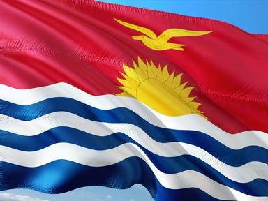
9. What does the lower half of the flag of Kiribati represent? Hint


Question 10 of 10
10. Given the fact that the Republic of Kiribati is entirely an island nation, it is not surprising that the issues of global warming and climate change are always being discussed there. In 2014 the country's government purchased land on which of the following nearby island countries? Hint


(Optional) Create a Free FunTrivia ID to save the points you are about to earn:

arrow Select a User ID:
arrow Choose a Password:
arrow Your Email:


View Image Attributions for This Quiz

Most Recent Scores
Dec 19 2024 : redwaldo: 10/10
Dec 14 2024 : Guest 98: 8/10
Nov 11 2024 : Guest 174: 7/10

Quiz Answer Key and Fun Facts
1. Today the Republic of Kiribati consists of 33 islands. One of the islands is classified as a coral island. How are the other islands classified?

Answer: Atolls

An atoll is formed after groups of coral polyps begin building colonies on a submerged volcanic island. Over time the coral polyps build up and form a reef which can result in the emergence of a new island. Atolls are a particular type of coral reef that are characterized by their shape - typically round or oval - with the presence of a lagoon near the center.

Twenty-one of the 32 atolls in the Republic of Kiribati are currently populated. While the land area of the nation is about 313 square miles, the islands are located in 1.4 million square miles of ocean. Marakei Atoll of the Republic of Kiribati is shown in the picture.
2. Many of the islands in the Republic of Kiribati are connected by raised roads, such as the Dai Nippon. What is the name for this type of raised road?

Answer: Causeway

Believe it or not, causeways have been constructed since Neolithic times to help people cross wet areas. The road can be raised in a variety of ways, such as packing down earth, or using building materials like wood, as was in the case of Sweet Track in England, which was constructed in the 3800s BC. Alexander the Great famously used a sandbar, labeled in the picture as a mole, that was topped with rubble to take the ancient city of Tyre in 332 BC. A mole is a type of causeway.

The Dai Nippon Causeway, completed in 1987, has improved communication and transportation between the islands in the Republic of Kiribati. Sand was used in its construction. There are some, however, who warn that similar causeways have changed the ocean currents and caused beach erosion in some areas of the world in the past. In addition, during bad weather causeways may become closed off, which hinders evacuations from certain areas.
3. Which island in the Republic of Kiribati is a coral island?

Answer: Banaba

Coral islands do begin as atolls, however, over time as more coral materials are deposited, an island may form. Raised by tectonic forces, the coral island will eventually sustain plant and animal life. There is very little water, however, and in the past the source of water on Banaba was a cave.

According to the 2010 census, there are three inhabited villages on Banaba, and fewer than 300 people live on the island. It is the western-point point of the Republic of Kiribati and contains the country's highest point at 285 feet.
4. What mineral ore, also found in Nauru, was discovered in the early 1900s in what became the Republic of Kiribati?

Answer: Phosphorus

Valuable deposits of phosphate rock were discovered on Banaba in the early 1900s. The phosphate rock there was formed from petrified guano through a process called phosphatization. After the phosphate rock is mined, it is crushed and becomes the key ingredient used to make commercial fertilizer.

Unfortunately, the discovery of the valuable mineral ore on Banaba in the early 1900s had a detrimental affect on life there. It is estimated that from 1906-1979 the island lost about 90% of its surface due to mining efforts. Lack of natural resources poses a definite economic challenge to the people of Kiribati, however, recent attempts to broach the subject of reopening phosphate mines have met resistance. Today the people of the Republic of Kiribati mainly earn a living from farming copra or fishing.

The phosphate mine in the picture is located on the island of Nauru.
5. Before 1999 the Republic of Kiribati consisted of 35 islands. Two of the islands disappeared into the sea.

Answer: True

Climate change is a very important issue in the Republic of Kiribati today. It has been estimated that since 1993 the average sea level has risen approximately 3.2 mm a year. While that may not sound like much, consider the impact that rising water of any kind has on low-lying islands. In 1999 the Republic of Kiribati lost two islands, Abanuea and Tebua Tarawa.

While neither of the islands were inhabited, they had been used as a base for fishermen. Climate change is not the only enemy here. Tropical storms also cause flooding and the contamination of fresh water supplies.
6. Why was January 1, 1995, an important date in the Republic of Kiribati?

Answer: Kiribati unilaterally moved the International Date Line.

Think about the problems caused by the International Date Line bisecting parts of the same country! That is exactly what had happened in the Republic of Kiribati. It's a small country, but because it covers about 1.4 million square miles in the ocean the old International Date Line, prior to 1995, made the western part of the Republic of Kiribati a day ahead of the eastern part.

Think about the complications in trade and communication that this would cause! It essentially gave the people a four day work week. That is why the International Date Line has an odd appearance on an updated map. It seems like it should be a straight line, but isn't! Since 2011 it was revised once more for reasons that did not involve the Republic of Kiribati.
7. Which island in the Republic of Kiribati shares the same name with the country's capital, and was the site of a WWII battle?

Answer: Tarawa

There are two parts to the island of Tarawa, North Tarawa and South Tarawa. The name means "The Passage", and indicates that the island has something that most atolls do not - a channel that allows for ships to enter its lagoon. Most of the island's population lives on South Tarawa, where many of the government agencies for the country are found.

Japanese forces occupied many of the Pacific Islands during WWII, and the United States needed a base from which to launch aircraft to take the Mariana Islands. It was decided that the Marshall Islands would support such as plan, but the Japanese had taken Tarawa, and their base on Betio, the largest island of the Tarawa Atoll, effectively cut off communication with Hawaii. So - in order to free the Marianas, the U.S. first had to start with Tarawa. The battle took place from November 20-23, 1943. The victory there enabled the United States to begin a strategy known as leapfrogging or island hopping.
8. As already stated, the Republic of Kiribati covers a huge area - 1.4 million square miles - in the Pacific Ocean. What term is used by geographers to describe the islands in the Pacific Ocean that are located between Asia and the Americas?

Answer: Oceania

The area called Oceania covers approximately 3,291,903 square miles and includes many smaller geographic subregions; these include Australasia, mainly Australia and New Zealand, Melanesia, the islands that are roughly located between New Guinea and Tongo, Polynesia, located in the central Pacific Ocean area, and Micronesia, the islands in the western Pacific Ocean.

While the Republic of Kiribati does not include islands in Australasia, it does have islands that are in the other three subregions.
9. What does the lower half of the flag of Kiribati represent?

Answer: The ocean

The current flag of Kiribati was adopted from a badge that was designed in 1931 for the flag of the Gilbert and Ellice Islands, which were British colonies at the time. The new flag was adopted on July 12, 1979, and is essentially a larger version of the badge.

The upper half is red with a yellow frigate bird flying over a yellow rising sun; the frigate bird represents power and freedom. The lower half is blue with three wavy horizontal white stripes to represent the Pacific Ocean, which, of course, encompasses the island nation.
10. Given the fact that the Republic of Kiribati is entirely an island nation, it is not surprising that the issues of global warming and climate change are always being discussed there. In 2014 the country's government purchased land on which of the following nearby island countries?

Answer: Fiji

Can you imagine the consternation that was felt by the people in the Republic of Kiribati in 1999 when two islands simply disappeared in the sea? There was also concern regarding the salination of the soil and the loss of what little farmland they have that could be caused by rising sea levels. Since 1999 environment studies have shown that rising sea levels can increase coral polyp activity, however, there is still concern that the sea level might, at some point, rise faster than the coral can grow.

In 2014 the government of the Republic of Kiribati purchased 5500 acres of land on one of the Fiji islands, Vanua Levu, with the intention of relocating people there if that ever became necessary. In the meantime, it appears that the land is being put to good use with some assistance from China. A 2021 article in the "Global Citizen" states that the property is currently being used to grow food to feed the people of the Republic of Kiribati. This seems like a win for the people who historically have struggled to grow their own food crops.
Source: Author ponycargirl

This quiz was reviewed by FunTrivia editor agony before going online.
Any errors found in FunTrivia content are routinely corrected through our feedback system.
12/22/2024, Copyright 2024 FunTrivia, Inc. - Report an Error / Contact Us