FREE! Click here to Join FunTrivia. Thousands of games, quizzes, and lots more!
Quiz about Things in British Columbia

Things in British Columbia Trivia Quiz


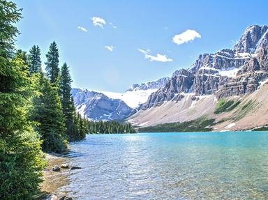
British Columbia (BC) is one of Canada's most beautiful provinces. Here are a few things that you might see on a road trip through the province. Use the photo clues even if you've never been there. Good luck.

A photo quiz by Trivia_Fan54. Estimated time: 4 mins.
  1. Home
  2. »
  3. Quizzes
  4. »
  5. Geography Trivia
  6. »
  7. Canada
  8. »
  9. British Columbia

Author
Trivia_Fan54
Time
4 mins
Type
Photo Quiz
Quiz #
406,327
Updated
Dec 03 21
# Qns
10
Difficulty
Average
Avg Score
6 / 10
Plays
251
Last 3 plays: 1MeanRick (8/10), portalrules123 (9/10), katyrose (7/10).
-
Question 1 of 10
1. How many official geographical regions will you find in Pacific Rim National Park Reserve? Hint


Question 2 of 10
2. What did the Queen Charlotte Islands come to be called in 2010? Hint


photo quiz
Question 3 of 10
3. The Trans-Canada Highway has a more northern alternate route through BC. Where is the western terminus of this alternate route? Hint


Question 4 of 10
4. In which body of water would you find the southernmost extremity of BC? Hint


photo quiz
Question 5 of 10
5. Where in northern BC can Mile Zero of the Alaska Highway be found? Hint


Question 6 of 10
6. Which of the following rivers are NOT located on Vancouver Island? Hint


photo quiz
Question 7 of 10
7. What is the tallest mountain in BC that is completely within the province? Hint


Question 8 of 10
8. When all provinces and territories are considered, where does British Columbia rank in land area, with "1" being the largest and "13" being the smallest? Hint


photo quiz
Question 9 of 10
9. What is NOT true about Tweedsmuir Park in BC? Hint


Question 10 of 10
10. What was the profession of the person after whom the capital of BC is named? Hint


photo quiz

Most Recent Scores
Dec 08 2024 : 1MeanRick: 8/10
Dec 02 2024 : portalrules123: 9/10
Nov 28 2024 : katyrose: 7/10

Quiz Answer Key and Fun Facts
1. How many official geographical regions will you find in Pacific Rim National Park Reserve?

Answer: 3

Pacific Rim National Park Reserve Is found on the west coast of Vancouver Island. It is named "National Park Reserve" in recognition of the rights of the Nuu-chah-nulth Tribal Council. There are three recognized regions in the park-reserve. Long Beach is located in Wickaninnish Bay between Tofino (NW) and Ucluelet (SE).

The beach is about sixteen km (ten mi) long and is known for its fine surfing. It is accessible by car. The Broken Group Islands are an archipelago of more than 100 islands and islets scattered around Barclay Sound. All are accessible only by water.

The West Coast Trail is the third region of the park-reserve. It is a 75KM (47 mile) hiking trail along sandstone cliffs, waterfalls, caves, sea arches, and beaches that make up the southern part of the park-reserve.
2. What did the Queen Charlotte Islands come to be called in 2010?

Answer: Haida Gwaii

The Haida Gwaii is an archipelago of the western coast of northern British Columbia. The islands were named the Queen Charlotte Islands in 1787 by a surveyor named Captain George Dixon. The islands were named after Charlotte of Mecklenburg-Strelitz, who was the wife of King George III in the United Kingdom.

The name "Haida Gwaii" was developed in the early 1980s. It simply means "islands of the Haida people". The name was officially changed after a law passed on June 3, 2010 that formalized the change.

There are two main islands in the archipelago, but about 400 in total. The islands have a total landmass of 10,180 sq km (3,931 sq mi).
3. The Trans-Canada Highway has a more northern alternate route through BC. Where is the western terminus of this alternate route?

Answer: Prince Rupert

The Trans-Canada Highway is one road that travels from coast-to-coast across the country. At some points, the road splits into alternate routes. This happens in Ontario, and in the prairies through to BC. The northern alternate for the Trans-Canada Highway in BC is known as the Yellowhead Highway or Highway #16.

It actually begins (or ends depending on the direction of travel) in Winnipeg, Manitoba and makes its way across the country at a more northerly level than the main route. Highway 16 crosses into BC from Alberta, with the first major junction in BC being Tete Jaune Cache.

It then travels west through Prince George and on to the coast at Prince Rupert. A 725-kilometre (450 mi) section of Highway 16 between Prince George and Prince Rupert is known as "The Highway of Tears" because of the high number of mainly Indigenous women who have gone missing or been found murdered along that stretch of road.
4. In which body of water would you find the southernmost extremity of BC?

Answer: Strait of Juan de Fuca

According to the United States Geological Survey, the Strait of Juan de Fuca is actually a channel. It is 154 km (96 miles) long. It was named by the fur trader Charles William Barkley in 1787. He named it after a Greek navigator that was on board a Spanish expedition.

The strait was extensively explored by the Spanish in the late 1700s. The international boundary between Canada and the US can be found in the centre of the strait. The actual southernmost extremity of BC is a point in the Strait of Juan de Fuca at 48°13′28.4″N 123°32′28.4″W.

The southernmost point of land in BC in an offshore nature reserve known as Race Rocks.
5. Where in northern BC can Mile Zero of the Alaska Highway be found?

Answer: Dawson Creek

The Alaska Highway was built by the Army Corps of Engineers during WWII from Dawson Creek, BC through the Yukon Territory, to Delta Junction, Alaska. It has since been extended to Fairbanks, Alaska. It was built to connect the "lower 48" states with Alaska with a road because of the fear of a Japanese invasion during the war.

The rough road, most suitable for trucks and tanks, was about 2,700 kilometres (1,700 mi) long when it was completed. It was started on March 9, 1942 and finished on October 28, 1942.

The Alaska Highway was opened to the public in 1948 as a mostly gravelled road, but is now completely paved, so is a lovely way to see the north. Fort St. John is an oil town on the Alaska Highway in northern BC, about 76 km (48 miles) north of Dawson Creek. Fort Nelson is also on the Alaska Highway, about 454 km (282 miles) north of Dawson Creek. Dawson City is in the Yukon, north of Whitehorse.

It is not located on the Alaska Highway, but is where the famous Klondike gold rush began.
6. Which of the following rivers are NOT located on Vancouver Island?

Answer: Seymour River

The Kokish River is in northern Vancouver Island and flows into Beaver Cove. Nimpkish River is the largest river on Vancouver Island. The Nahwitti River is also in the northern part of Vancouver Island. Its name comes from the Kwakwakaʼwakw First Nation village of Nahwitti that existed during the fur trade from the late 18th to the mid-19th century.

The Seymour River is located in North Vancouver, a city on the mainland. It is known to be a few degrees warmer than other rivers in the area because it is fed by a reservoir that is held by a dam.

The Seymour River is the main water source for the city of North Vancouver.
7. What is the tallest mountain in BC that is completely within the province?

Answer: Mount Waddington

The highest mountain completely within British Columbia is Mount Waddington at 4,019 m (13,186 ft) at the summit. It is in the Pacific Ranges of the Coast Mountains. Mount Logan is the highest mountain in Canada, and the second highest mountain in North America at 5,959 metres (19,551 ft). Mount Fairweather in BC has a higher summit than Mount Waddington, but it sits on the border with Alaska, so it is not wholly within the province. Mount Fairweather has an elevation of 4,671 metres (15,325 ft). Mount Columbia is the highest mountain in Alberta, BC's neighbour to the east.

Its elevation is 3,747 m (12,293 ft).
8. When all provinces and territories are considered, where does British Columbia rank in land area, with "1" being the largest and "13" being the smallest?

Answer: 4

BC has a land area of 925,186 square km (357,216 square mi). The northern territory of Nunavut has the largest land area in Canada with 1,936,113 square km (747,551 square mi). Quebec is the largest province by land area, with 1,365,128 square km (527,088 sq mi). Third in area for the country of Canada is the Northwest Territories with 1,183,085 square km (456,800 square mi). BC is fourth in size when all provinces and territories are considered, but second largest amongst the provinces.
9. What is NOT true about Tweedsmuir Park in BC?

Answer: It is the only Provincial Park on Vancouver Island

British Columbia has a total of 644 Provincial Parks. Of those, there are actually 83 Provincial Parks on Vancouver Island. Tweedsmuir Park is BC's largest Provincial Park. It is 9896 square km (3821 square mi). The park is made up of two areas - Tweedmuir Park North and Tweedsmuir Park South.

The Park is located just over 450 km (280 mi) northwest of Vancouver as the crow flies. The park provides a vital habitat for woodland caribou. Popular activities in the park include fishing, hiking, canoeing, and camping.
10. What was the profession of the person after whom the capital of BC is named?

Answer: Royalty

The capital of British Columbia is Victoria on Vancouver Island. It is named after Queen Victoria. Many think that Vancouver is the capital. It is a city on the mainland that is larger than Victoria, but it was named after the English navigator George Vancouver, of the Royal Navy. He had explored the west coast of Canada in 1792.
Source: Author Trivia_Fan54

This quiz was reviewed by FunTrivia editor agony before going online.
Any errors found in FunTrivia content are routinely corrected through our feedback system.
12/22/2024, Copyright 2024 FunTrivia, Inc. - Report an Error / Contact Us