FREE! Click here to Join FunTrivia. Thousands of games, quizzes, and lots more!
Quiz about Baby Its Cold Outside

Baby, It's Cold Outside Trivia Quiz


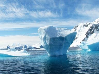
Brr -- it's freezing out here! Come with me to the ends of the earth, and test your knowledge of the Arctic and Antarctic Circles.

A multiple-choice quiz by CellarDoor. Estimated time: 5 mins.
  1. Home
  2. »
  3. Quizzes
  4. »
  5. Geography Trivia
  6. »
  7. Polar Regions

Author
CellarDoor
Time
5 mins
Type
Multiple Choice
Quiz #
319,885
Updated
Jul 23 22
# Qns
10
Difficulty
Average
Avg Score
6 / 10
Plays
1207
Awards
Top 5% quiz!
- -
Question 1 of 10
1. Let's figure out just what is included in the polar regions -- that is, the region north of the Arctic Circle and the region south of the Antarctic Circle. Why is the Arctic Circle drawn where it is on the globe? Hint


Question 2 of 10
2. The line of the Arctic Circle crosses three continents: Asia, Europe, and North America. How many continents are crossed by the Antarctic Circle? Hint


Question 3 of 10
3. If you go to the Arctic and get out your compass, you'll soon find that the geographic North Pole and the North Magnetic Pole are not the same thing. Do both of them stay in a single location, year to year and decade to decade? Hint


Question 4 of 10
4. The Pacific Ring of Fire is justly famous for its many volcanoes and seismic faults, but many people fail to realize that it extends even into a land of snow and ice: Antarctica. In fact, Ross Island is home to the world's southernmost active volcano, Mt. Erebus. How were Mt. Erebus and its neighbor, Mt. Terror, named? Hint


Question 5 of 10
5. Just south of the Arctic Circle is one of the most momentous bodies of water in the history of humankind. This strait now separates Russia and Alaska, but, during the Ice Age, the continents were connected here by a narrow bridge of land. And, more than ten thousand years ago, people ventured across that bridge and thus discovered, explored and settled the Americas. What is the name of the strait? Hint


Question 6 of 10
6. On a map, one of Antarctica's most distinctive features is a long, sinuous peninsula some 800 miles (1300 kilometers) long and bordering the Weddell Sea. Toward which other land mass does the Antarctic Peninsula appear to reach? Hint


Question 7 of 10
7. In days of yore, European explorers sailed the Arctic Ocean, searching for a northerly sea route between Europe and Asia. Now, this once-mythical route is in the news again, as global warming shrinks the Arctic ice pack and offers the prospect of a regular summer shipping lane. By what name is this sea route known? Hint


Question 8 of 10
8. Antarctica is the only continent that human beings didn't manage to settle in antiquity. You might think the Arctic would be just as harsh, but it's home to several hundred thousand people. Which of the following cities is north of the Arctic Circle? Hint


Question 9 of 10
9. Antarctica is cold and dry; much of the continent is actually desert. But, strangely enough, there is surface water if you look in the right place at the right time. Near McMurdo Sound, there's even a river 20 miles (32 kilometers) long. What is its name? Hint


Question 10 of 10
10. The Svalbard Islands, in the far north of the Arctic Ocean, may seem remote, but one day the fate of humanity may be decided on their icy shores. This Norwegian archipelago is home to a high-security vault that houses a massive stockpile of what item, essential for civilization? Hint


(Optional) Create a Free FunTrivia ID to save the points you are about to earn:

arrow Select a User ID:
arrow Choose a Password:
arrow Your Email:


Most Recent Scores
Oct 09 2024 : DCW2: 10/10
Sep 24 2024 : emmal2000uk: 1/10

Score Distribution

quiz
Quiz Answer Key and Fun Facts
1. Let's figure out just what is included in the polar regions -- that is, the region north of the Arctic Circle and the region south of the Antarctic Circle. Why is the Arctic Circle drawn where it is on the globe?

Answer: North of the Arctic Circle, every year sees at least 24 hours of continuous sunlight and at least 24 hours of continuous night.

The Antarctic Circle is defined in much the same way, though its long night comes at the same time as the Arctic Circle's long day. (It's this long polar day that gives rise to the phrase "land of the midnight sun.") The tilt of the Earth's axis makes the long polar days and nights possible: at each solstice, one pole is tilted entirely toward the sun while the other is pointed entirely away.

Earth's axial tilt varies, in a range of a few degrees, over a 41,000-year cycle (a geological eyeblink). This change in angle means that the Arctic and Antarctic Circles are moving, too -- racing toward the poles at the breakneck speed of 15 meters (49 feet) a year. Presently, they're at a little over 66.5 degrees north and south latitude, respectively.
2. The line of the Arctic Circle crosses three continents: Asia, Europe, and North America. How many continents are crossed by the Antarctic Circle?

Answer: One: parts of Antarctica are north of the Circle.

When you're used to seeing Antarctica only at the bottom of a Mercator-projection map, it's easy to forget how big a land mass it is. It really is a continent, though, and it's bigger than either Europe or Australia. Antarctica accounts for most of the region enclosed by the Antarctic Circle, although some of that region is ocean and some of Antarctica falls outside.

By contrast, the Arctic Circle encloses mostly ocean, but passes through a whopping eight countries. Moving westward from the International Date Line, these are: Russia, Finland, Sweden, Norway, Iceland (via Grimsey Island), Denmark (via its dependency of Greenland), Canada, and the U.S.A. (via the state of Alaska).
3. If you go to the Arctic and get out your compass, you'll soon find that the geographic North Pole and the North Magnetic Pole are not the same thing. Do both of them stay in a single location, year to year and decade to decade?

Answer: No: the magnetic pole moves at a rate of several kilometers a year.

The line between the Earth's two geographic poles (North and South) is the axis on which the Earth rotates. This axis wobbles a little bit, causing the geographic poles to move -- but only in a range of a few meters (several feet).

The magnetic poles, on the other hand, are defined based on the Earth's magnetic field: they're the places where the field lines point straight up (at the South Magnetic Pole) or straight down (at the North Magnetic Pole). But there's a lot of variation in the Earth's magnetic field, because of changes in the way the molten iron flows, deep within the planet -- so the magnetic poles drift. The North Magnetic Pole, which is better mapped than the South, has been clocked at 41 kilometers (25 miles) of northwest-ward motion in a single year!
4. The Pacific Ring of Fire is justly famous for its many volcanoes and seismic faults, but many people fail to realize that it extends even into a land of snow and ice: Antarctica. In fact, Ross Island is home to the world's southernmost active volcano, Mt. Erebus. How were Mt. Erebus and its neighbor, Mt. Terror, named?

Answer: After the ships in Sir James Clark Ross's polar expedition

Having acquired a taste for polar exploration on several Arctic voyages with his father, Ross arrived in the Antarctic in 1839. His ships, HMS Erebus and HMS Terror, had been commissioned as bomb ships, and their thick hulls made them well suited to coping with Antarctica's treacherous, icy waters. They brought Ross's expedition safely around much of the Antarctic coastline, surveying and mapping; it was this group that discovered the gargantuan Ross Ice Shelf. Grateful to his ships, Ross named two volcanoes after them: active Mt. Erebus, and extinct Mt. Terror.

Sadly, HMS Erebus and HMS Terror were not invincible. A few years later, they were used in Sir John Franklin's expedition to the Canadian Arctic, where every man perished (apparently due to cold and starvation).
5. Just south of the Arctic Circle is one of the most momentous bodies of water in the history of humankind. This strait now separates Russia and Alaska, but, during the Ice Age, the continents were connected here by a narrow bridge of land. And, more than ten thousand years ago, people ventured across that bridge and thus discovered, explored and settled the Americas. What is the name of the strait?

Answer: Bering Strait

In the Ice Age, so much of the world's seawater was locked up in ice sheets and glaciers that sea level was much lower than it is today. (This is the flip side of the modern problem of global warming, where melting ice sheets make sea levels rise and coastlines flood.) As sea level fell in the last Ice Age, the shallow waters of the Bering Strait (only two meters deep in places!) receded, exposing the former sea floor. Local people, ever resourceful, came right across, and the rest is history.
6. On a map, one of Antarctica's most distinctive features is a long, sinuous peninsula some 800 miles (1300 kilometers) long and bordering the Weddell Sea. Toward which other land mass does the Antarctic Peninsula appear to reach?

Answer: South America

The name "Antarctic Peninsula" is a bit misleading, as it isn't really one continuous mass of land. Instead, it is made up of both a standard-issue peninsula and a number of island chains, all joined together by massive ice sheets (the largest of which is the Larsen Ice Shelf).

The whole thing stretches up toward Cape Horn, the southernmost tip of South America: the two continents are separated by only about a thousand miles (1600 kilometers).
7. In days of yore, European explorers sailed the Arctic Ocean, searching for a northerly sea route between Europe and Asia. Now, this once-mythical route is in the news again, as global warming shrinks the Arctic ice pack and offers the prospect of a regular summer shipping lane. By what name is this sea route known?

Answer: The Northwest Passage

The Northwest Passage, named from the perspective of Europeans seeking westward trade routes, was a Holy Grail for explorers from the 15th century to the 19th. Portugal controlled the southeast trade routes (around the tip of Africa) while Spain controlled the southwest (around the tip of South America); this left their rivals, England and France, keen to discover another path. Numerous famed explorers tried and failed to find it, including John Cabot, Jacques Cartier, and Henry Hudson.

In 1906, Roald Amundsen became the first to sail the Northwest Passage, although his path was too shallow in places for commercial vessels. Changes in the distribution of ice packs make this route very different from season to season, but global warming may make it a viable shipping lane. This would please Canada's government, which has already claimed full sovereignty over much of the Passage.
8. Antarctica is the only continent that human beings didn't manage to settle in antiquity. You might think the Arctic would be just as harsh, but it's home to several hundred thousand people. Which of the following cities is north of the Arctic Circle?

Answer: Murmansk, Russia

Murmansk, the capital of Murmansk Oblast (an administrative district similar to a province), is a relatively new city. It was founded in 1916 to take advantage of the area's ice-free harbor, kept clear for shipping by warm ocean currents from the North Atlantic. Just off the Barents Sea, the city is home to some 330,000 people, as well as a fleet of ice-breaking vessels powered by nuclear reactors.
9. Antarctica is cold and dry; much of the continent is actually desert. But, strangely enough, there is surface water if you look in the right place at the right time. Near McMurdo Sound, there's even a river 20 miles (32 kilometers) long. What is its name?

Answer: Onyx River

The Onyx flows only during the short Antarctic summer, of course. It carries glacial runoff to Lake Vanda. There is no snow or ice cover in this region, so the area is known as the Dry Valleys -- a slightly odd moniker for the home of Antarctica's most important river.

The wrong answer choices are also rivers in the southern hemisphere: the Darling is in Australia, the Deseado in Argentina, and the Orange in South Africa.
10. The Svalbard Islands, in the far north of the Arctic Ocean, may seem remote, but one day the fate of humanity may be decided on their icy shores. This Norwegian archipelago is home to a high-security vault that houses a massive stockpile of what item, essential for civilization?

Answer: Seeds

The Svalbard Global Seed Vault, located inside a mountain on Spitsbergen Island, opened its doors in 2008. Its goal is to serve as a backup repository for the seeds of domesticated and wild food plants. Many nations keep such seed banks themselves, but these repositories are vulnerable to wars and natural disasters, as well as to more mundane problems (like funding cuts). Svalbard makes an excellent backup, even in a global catastrophe.

It's remote -- only 2000 people live in the entire archipelago -- so it's an unlikely target for attack.

The site isn't near any seismic faults, deep layers of permafrost keep it cool, and its altitude protects it from rising sea levels. Even better, it's funded from multiple sources -- both governments and philanthropic organizations.
Source: Author CellarDoor

This quiz was reviewed by FunTrivia editor gtho4 before going online.
Any errors found in FunTrivia content are routinely corrected through our feedback system.
11/21/2024, Copyright 2024 FunTrivia, Inc. - Report an Error / Contact Us