FREE! Click here to Join FunTrivia. Thousands of games, quizzes, and lots more!
Quiz about Cruising Antarctica

Cruising Antarctica Trivia Quiz


On January 13/11 the Star Princess entered Antarctic waters for what will probably be the last time. I was lucky enough to be on the ship for her last tour of this amazing continent. These pictures are from that voyage.

A photo quiz by skunkee. Estimated time: 4 mins.
  1. Home
  2. »
  3. Quizzes
  4. »
  5. Geography Trivia
  6. »
  7. Polar Regions

Author
skunkee
Time
4 mins
Type
Photo Quiz
Quiz #
335,249
Updated
Jul 23 22
# Qns
10
Difficulty
Average
Avg Score
7 / 10
Plays
1287
Awards
Top 10% Quiz
Last 3 plays: ssabreman (9/10), Southendboy (10/10), Guest 174 (8/10).
-
Question 1 of 10
1. Sailing southwest from the Falkland Islands, this island was our first glimpse of land in Antarctic waters. Unfortunately it was shrouded in mist and rain at the time. Its name comes from both the general shape of the island, and from the mammal that was sighted there by early explorer, George Powell. Which island is this? Hint


Question 2 of 10
2. We were fortunate enough to see quite a few of these magnificent whales feeding on the krill and small fish abundant in the cold waters of Antarctica. Shortly after this picture was taken, he showed us his magnificent tail flukes, which are as unique in his world as finger prints are in ours. What type of whale is this, that characteristically displays its tail flukes while diving? Hint


Question 3 of 10
3. Many countries have research stations in Antarctica; some are only open in the summer while others are staffed year round. The Star Princess participated in a staffing exchange for the Arctowski Research Station, seen here on King George Island, in Admiralty Bay. To what country does the Arctowski Station belong? Hint


Question 4 of 10
4. Taking a break on a floating iceberg, these Adelie penguins are one of the many breeds of penguins that live in Antarctica. The largest breed of penguin lives exclusively in Antarctica. What is it? Hint


Question 5 of 10
5. This exquisite iceberg was seen floating along in the Antarctic Sound. By what name is this passage commonly referred to? Hint


Question 6 of 10
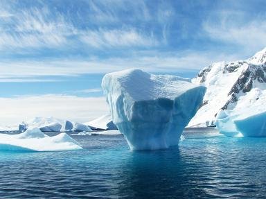
6. This iceberg was so large, it was hard to believe that it was actually an iceberg and not a shoreline. What kind of berg is this? Hint


Question 7 of 10
7. Although these mountains are snow covered, this picture shows a peak on the warmest part of Antarctica - the only part of the mainland that isn't snow and ice covered year round. Where is it? Hint


Question 8 of 10
8. This picture was taken while cruising in the Gerlache Strait. What is the cause of the turquoise streaks? Hint


Question 9 of 10
9. This picture shows Deception Island, on what we were told was a remarkably clear day. Apparently Deception Island is more often shrouded in fog than not. What is deceptive about Deception Island? Hint


Question 10 of 10
10. This picture shows Cape Horn, the southernmost tip of South America. To get there from Antarctica, you have to cross one of the most difficult pieces of water to navigate. What's it called? Hint


(Optional) Create a Free FunTrivia ID to save the points you are about to earn:

arrow Select a User ID:
arrow Choose a Password:
arrow Your Email:


View Image Attributions for This Quiz

Most Recent Scores
Dec 23 2024 : ssabreman: 9/10
Dec 08 2024 : Southendboy: 10/10
Nov 27 2024 : Guest 174: 8/10
Nov 14 2024 : misstified: 9/10
Nov 10 2024 : Nicobutch: 9/10

Score Distribution

quiz
Quiz Answer Key and Fun Facts
1. Sailing southwest from the Falkland Islands, this island was our first glimpse of land in Antarctic waters. Unfortunately it was shrouded in mist and rain at the time. Its name comes from both the general shape of the island, and from the mammal that was sighted there by early explorer, George Powell. Which island is this?

Answer: Elephant Island

Looking at a map of the island is like looking down on the top of an elephant's head, with two big ears and a protruding trunk. When Captain George Powell first sighted the island, in 1821, there were large numbers of elephant seals populating the island's coastline.

The seals have been seen there pretty much every year since, but alas, visibility wasn't good enough for us to tell whether there were any there when we passed by.
2. We were fortunate enough to see quite a few of these magnificent whales feeding on the krill and small fish abundant in the cold waters of Antarctica. Shortly after this picture was taken, he showed us his magnificent tail flukes, which are as unique in his world as finger prints are in ours. What type of whale is this, that characteristically displays its tail flukes while diving?

Answer: Humpback

Humpback whales tend to feed in the colder waters, including polar regions, in the summer and retire to the warmer waters nearer the equator during breeding time, where they mostly live off of their fat reserves. Their yearly migrations can be as much as 25,000 km long. They are baleen whales, lacking teeth, and they tend to feed by lunging at their prey.

They have developed an interesting approach to feeding, which is sometimes called bubble net feeding. The whales dive down and blow a ring of air bubbles around a school of fish.

The fish react to the bubbles as if they form a physical barrier that they cannot cross. The whales then swim up through the school of captive fish, with their mouths open. We saw a pod of 13 whales feed this way in Alaska, and it's an amazing sight to see.
3. Many countries have research stations in Antarctica; some are only open in the summer while others are staffed year round. The Star Princess participated in a staffing exchange for the Arctowski Research Station, seen here on King George Island, in Admiralty Bay. To what country does the Arctowski Station belong?

Answer: Poland

The Arctowski Research Station was established in 1977 and it is one of the stations that is staffed year round. It is named after Henryk Arctowski, a Polish meteorologist who explored Antarctica in the 19th century.
The Star Princess brought four Polish scientists down with us, as well as some fresh supplies for the station. A dinghy bearing three departing scientists motored out to the ship to effect the exchange.
4. Taking a break on a floating iceberg, these Adelie penguins are one of the many breeds of penguins that live in Antarctica. The largest breed of penguin lives exclusively in Antarctica. What is it?

Answer: Emperor Penguin

All of the penguins listed have colonies in Antarctica, but the Emperor is by far the largest, standing approximately up to 48 inches in height and weighing anywhere between 55-99 pounds. We weren't fortunate enough to see any Emperor penguins because they are hard core Antarctica dwellers, living mainly on the mainland, where they endure some of the coldest winters in the world, with temperature diving lower than -40 degress (which is where the Celsius and Fahrenheit scales seem to converge).
5. This exquisite iceberg was seen floating along in the Antarctic Sound. By what name is this passage commonly referred to?

Answer: Iceberg Alley

Antarctic Sound, or Iceberg Alley as it is often called, is a passage of water that runs between the Antarctic Peninsula and Joinville and D'Urville Islands. It connects the Weddell Sea, with its permanent ice shelf, and the Bransfield Strait, which is navigable in the Antarctic summer.
We spent an entire day watching literally hundreds of icebergs on and around Iceberg Alley, in many shapes and sizes.
It's not an exclusive name, as we've also visited an Iceberg Alley along the coast of Newfoundland in Canada.
There really is a Terror Gulf - it is part of the Weddell Sea on the southern end of the Antarctic Sound.
6. This iceberg was so large, it was hard to believe that it was actually an iceberg and not a shoreline. What kind of berg is this?

Answer: a tabular iceberg

Tabular icebergs are so named because of their flat appearance, like a table top. They are most common in Antarctica and have broken off from the ice shelves that cover Antarctic waters. The ones we saw would have been from the ice shelves in the Weddell Sea, located on the southern side of the Antarctic Peninsula, between it and the mainland.

The largest tabular iceberg ever recorded was more than 12,000 sq. miles in size, which is actually larger than the country Belgium.
7. Although these mountains are snow covered, this picture shows a peak on the warmest part of Antarctica - the only part of the mainland that isn't snow and ice covered year round. Where is it?

Answer: Antarctic Peninsula

Land that isn't covered year round by ice is in short supply in Antarctica, so the Antarctic Peninsula is home to most of the research stations located there, particularly on its northern shore (and on the islands). The Antarctic Peninsula is located below South America and was first sighted around 1820.
Sadly, this beautiful part of the world is also being affected by global warming, with studies showing both an increase in average temperatures and a massive ice loss.
8. This picture was taken while cruising in the Gerlache Strait. What is the cause of the turquoise streaks?

Answer: glacial ice

In the simplest terms, glaciers are the result of large amounts of sleet and snow that accumulated faster than it melted. The pressure of the snow on itself caused the snow and ice to become denser and more compact, until it became glacial ice. The bright blue streaks that are typically found in glacial ice are the result of light reflection.

The ice absorbs the reds and orange of light and reflects back the blues, much in the same way that water does. This particular glacier is still advancing, in that it reaches the water's edge and there is evidence of pieces of the glacier breaking off or 'calving' into the water.

Many of the glaciers around the world are retreating.
9. This picture shows Deception Island, on what we were told was a remarkably clear day. Apparently Deception Island is more often shrouded in fog than not. What is deceptive about Deception Island?

Answer: It's really an active volcano.

If you approach Deception Island from any other side, it looks like a regular island, which is home to thousands of Chinstrap Penguins. However the opening seen in the picture, which can be navigated by smaller boats, leads to the water filled crater of the volcano.

Here you can bathe in waters warmed by the volcano, if you don't mind penguin excrement. Years ago it was used as a whaling station, because of the safe harbour it provided and comparative warmth. Chilean research stations and a British base on Deception Island have been destroyed by volcanic activity in 1967 and 1969.
10. This picture shows Cape Horn, the southernmost tip of South America. To get there from Antarctica, you have to cross one of the most difficult pieces of water to navigate. What's it called?

Answer: The Drake Passage

Situated between Antarctica and South America, the Drake Passage is where the Atlantic and Pacific Oceans meet. This can make for some very interesting sea conditions. But it's all in the luck of the draw. When we crossed the Drake, we were subjected to rain and hurricane force winds. However fellow passengers, who had made the trip before, reported crossings where the water was like glass.
It was named after the English explorer, Sir Francis Drake. It was 'discovered' by Drake when his ship was blown off course.
Source: Author skunkee

This quiz was reviewed by FunTrivia editor spanishliz before going online.
Any errors found in FunTrivia content are routinely corrected through our feedback system.
1/9/2025, Copyright 2025 FunTrivia, Inc. - Report an Error / Contact Us