FREE! Click here to Join FunTrivia. Thousands of games, quizzes, and lots more!
Quiz about An Arctic Dip

An Arctic Dip Trivia Quiz


Take the plunge with me and my expedition as we explore the (almost) seven seas of the Arctic Ocean - it's more than a boring, frozen wasteland. But don't forget to wear plenty of layers.

A multiple-choice quiz by malik24. Estimated time: 5 mins.
  1. Home
  2. »
  3. Quizzes
  4. »
  5. Geography Trivia
  6. »
  7. Polar Regions

Author
malik24
Time
5 mins
Type
Multiple Choice
Quiz #
345,238
Updated
Aug 22 24
# Qns
10
Difficulty
Average
Avg Score
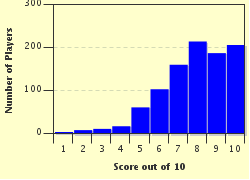
8 / 10
Plays
3491
Awards
Top 10% Quiz
Last 3 plays: bluepeter46 (9/10), Kalibre (6/10), Guest 75 (3/10).
- -
Question 1 of 10
1. Several rivers bring freshwater into the Arctic Ocean, and whilst travelling, we might be able to see some of them. Which of these rivers would we definitely NOT see, because it does not empty into the Arctic Ocean? Hint


Question 2 of 10
2. Although we won't actually be diving on our trip, the deepest point in the Arctic Ocean, in the Eurasia Basin, is around half that of the deepest point in the world, the Mariana Trench.


Question 3 of 10
3. Properly beginning our trip, we'll want to traverse the Northwest Passage. Named after the explorer who described it in detail, and adjacent to an island of the same name, which of these Arctic bodies of water is situated between Greenland and Northwest Canada, and is an entry to the Northwest Passage? Hint


Question 4 of 10
4. From the Inuit hamlet of Tuktoyaktuk, one could coolly look out to our next sea, which was named after an Irish hydrographer, although there has been dispute between the USA and Canada over its borders. Where are we now? Hint


Question 5 of 10
5. The Bering Strait, which lies just outside the Arctic Circle, terminates the Northwest Passage, which could lead us to the Pacific Ocean. However, we don't want to stop here! What is the name of the sea, named after its inhabitants, by which we could reach the Bering Strait? Hint


Question 6 of 10
6. The East Siberian Sea is surrounded by particularly harsh terrain, and is one of the least studied seas in the Arctic Ocean. Which of these island groups, with a highest elevation point of only 374m, separates the East Siberian Sea from the Laptev Sea? Hint


Question 7 of 10
7. The Laptev Sea can reach temperatures of -50C and flora, fauna and human influence is relatively low, so we had cold feet at the prospect of staying here for long! However, it does have another claim to fame; is it true or false that the Laptev Sea has the greatest amount of glacial shrinking in the Arctic Ocean?


Question 8 of 10
8. Our next stop, the Kara Sea, holds many secrets. Which of these facts about the Kara Sea is false? Hint


Question 9 of 10
9. We've braved the worst of the journey, since North Atlantic drift helps to bring a surprising amount of wildlife to our next sea, and it is an important fishery to Norway and Russia, which lie to the south. Although it used to be named the Murman Sea, what is the name of this chilly expanse today? Hint


Question 10 of 10
10. Before we can chill out, we must navigate the final sea in our journey, which both borders and shares its name with the largest island in the world. This sea also borders Iceland and the Norwegian Sea to the south, and the Svalbard Archipelago to the east. Where are we?

Answer: (Two words (9 letters, 3 letters), think of a colour)

(Optional) Create a Free FunTrivia ID to save the points you are about to earn:

arrow Select a User ID:
arrow Choose a Password:
arrow Your Email:


Most Recent Scores
Jan 03 2025 : bluepeter46: 9/10
Dec 11 2024 : Kalibre: 6/10
Dec 09 2024 : Guest 75: 3/10
Nov 25 2024 : Mpproch: 8/10

Score Distribution

quiz
Quiz Answer Key and Fun Facts
1. Several rivers bring freshwater into the Arctic Ocean, and whilst travelling, we might be able to see some of them. Which of these rivers would we definitely NOT see, because it does not empty into the Arctic Ocean?

Answer: Rhine

The Ob and Lena rivers are both Siberian, whereas the Mackenzie River is Canadian. Since over 2/3 of the world's freshwater is frozen in icecaps and glaciers, we have a relatively limited source of freshwater to work with, making it a precious commodity.

The Ob is the seventh longest river in the world, and the Ob also has the largest estuary (river mouth) in the world. The Lena's claim to fame is its river delta, which is impressive to behold, and it's also a protected area by the Russians. Meanwhile, the Mackenzie is the largest river in Canada, and is the largest outside the Ob, Lena and Yenisei to deposit into the Arctic Ocean.

Since the Rhine goes from Switzerland to the North Sea at the Netherlands, we are not very likely to see it on our journey.
2. Although we won't actually be diving on our trip, the deepest point in the Arctic Ocean, in the Eurasia Basin, is around half that of the deepest point in the world, the Mariana Trench.

Answer: True

The Mariana Trench goes to 10,924m below sea level, against the 5450m of the Eurasia Basin in the Arctic Ocean, which is, surprisingly, almost exactly half the depth. The Eurasia Basin was said to have been formed 63 million years ago in the Cenozoic period.

The Arctic Ocean is the smallest of the five world oceans, but that does not mean there is not a lot of interesting things to find there. It touches three continents - North America, Europe and Asia - and is the only home to polar bears. In fact, it is home to many forms of wildlife; caribou, seals, a variety of fish and narwhals live in the Arctic. However, because there is sea ice on the surface for a large amount of the year, travelling by sea is difficult, but can be done when the time is right!
3. Properly beginning our trip, we'll want to traverse the Northwest Passage. Named after the explorer who described it in detail, and adjacent to an island of the same name, which of these Arctic bodies of water is situated between Greenland and Northwest Canada, and is an entry to the Northwest Passage?

Answer: Baffin Bay

William Baffin explored the Arctic Circle in 1615-6, purportedly in search of the Northwest Passage, which is known now to connect the Atlantic and Pacific Oceans through the Arctic Ocean. At the time he could not find it, but he did carefully describe areas of the Arctic such as the Hudson Strait, and he mapped the entire of Baffin Bay on his fifth expedition - although, amusingly, his notes on his findings were discredited until the 1800s, when his findings were found to be correct.

In his honour, Baffin Bay and Baffin Island were named after him. Baffin Bay is also known for its beluga whale population, and Baffin Island houses Iqaluit, the capital of Nunavut, one of the Canadian territories.
4. From the Inuit hamlet of Tuktoyaktuk, one could coolly look out to our next sea, which was named after an Irish hydrographer, although there has been dispute between the USA and Canada over its borders. Where are we now?

Answer: Beaufort Sea

Tuktoyaktuk has had a fairly stable population of around 900-1000 between 1999 and 2009. The name is more sensibly referred to as 'Tuk' typically, and near Tuk lies the largest concentration of pingos in the world, and pingos are core mounds of ice with layers of ground on top.

The Beaufort Sea is named after Francis Beaufort, who developed the Beaufort scale of wind force. The Mackenzie river empties into the Beaufort Sea through the large Mackenzie Delta, and the sea also has large reserves of fossil fuels beneath it, which have been largely untapped into since the 1980s. The border dispute concerns the area of the sea between Yukon, a Canadian territory, and Alaska, an American state, and is likely important to determine who can extract the fossil fuels located in that area.
5. The Bering Strait, which lies just outside the Arctic Circle, terminates the Northwest Passage, which could lead us to the Pacific Ocean. However, we don't want to stop here! What is the name of the sea, named after its inhabitants, by which we could reach the Bering Strait?

Answer: Chukchi Sea

The Chukchi Sea is named after the Chukchi people of Russia, who still live on the western shoreline at Alyatki and Uelen. The Bering Strait, at the southern edge of the Chukchi Sea, connects the Chukchi Sea and the Bering Sea, and the Pacific Ocean past that.

It is policed by the USA and Russia, making permission for explorers and travellers necessary, particularly if they would dock on Russian or American land soon after. In August 2011, the Russians approved the production of a tunnel crossing the Bering Strait, which would cost around £60bn.
6. The East Siberian Sea is surrounded by particularly harsh terrain, and is one of the least studied seas in the Arctic Ocean. Which of these island groups, with a highest elevation point of only 374m, separates the East Siberian Sea from the Laptev Sea?

Answer: New Siberian Islands

The largest of these islands is the Kotelny Island, which is the 47th largest island by area in the world, and also houses the highest elevation point of the islands. The islands house ivory from mammoths, which is in very good condition because of the permafrost it was encased in. Some of this ivory could be over 50,000 years old!
7. The Laptev Sea can reach temperatures of -50C and flora, fauna and human influence is relatively low, so we had cold feet at the prospect of staying here for long! However, it does have another claim to fame; is it true or false that the Laptev Sea has the greatest amount of glacial shrinking in the Arctic Ocean?

Answer: False

Actually, the Laptev Sea has a large amount of glacial growth. It exports arctic sea ice out, with an average flow of 483,000 km squared from 1979-1995. This occurs all year except for July, August and September, and has a larger glacial growth than the Barents Sea, Kara Sea, East Siberian Sea and Chukchi Sea combined.

Some might say this is the cold heart of the Arctic for that reason. It is located largely between the Severnaya Zemlya and the New Siberian Islands, and is north of Siberia.
8. Our next stop, the Kara Sea, holds many secrets. Which of these facts about the Kara Sea is false?

Answer: It is a favourite breeding ground for penguins

Since penguins almost exclusively inhabit the southern hemisphere, you wouldn't find any in the Kara Sea, or anywhere else in the Arctic Ocean. And, despite it being next to the Barents Sea, it is much colder, being frozen for around nine months a year. It is separated from the Barents Sea to the west by the Novaya Zemlya, an archipelago north of Russia, and to the east by the Laptev Sea by the Severnaya Zemlya, a smaller archipelago. Since the Arctic Ocean is relatively shallow, it is not surprising this particular sea has a low depth.

In 1992, a report was released detailing the nuclear waste in the Kara Sea by the Soviet Union from the 60s to the 80s - which included six nuclear submarines and 10 nuclear reactors, amongst other waste. Although there has been concern over the potential radiation from this waste, a report has suggested that the level of contamination is low outside the immediate dumping sites.
9. We've braved the worst of the journey, since North Atlantic drift helps to bring a surprising amount of wildlife to our next sea, and it is an important fishery to Norway and Russia, which lie to the south. Although it used to be named the Murman Sea, what is the name of this chilly expanse today?

Answer: Barents Sea

The Barents Sea is named after Willem Barents, a Dutch navigator and explorer. Note that its former name, the Murman Sea, or Murmanskye Morye, meant the sea of the Norwegians.

The North Atlantic Drift continues the Gulf Stream, a warm sea current which originates around Florida and goes across northern Europe, making it warmer than it would otherwise be. This helps to explain why there is more life supported in the Barents Sea compared to other areas of similar latitude. Cod, whales, auks and guillemots are just some of the wildlife found in and around the Barents Sea.
10. Before we can chill out, we must navigate the final sea in our journey, which both borders and shares its name with the largest island in the world. This sea also borders Iceland and the Norwegian Sea to the south, and the Svalbard Archipelago to the east. Where are we?

Answer: Greenland Sea

From the central region of this sea, we could head south to the UK, which is where our trip would end (well, it would for me, since that's where I live!). The Greenland Sea is also home to numerous lifeforms, and the harp and hooded seals here make it a popular seal hunting ground. The sea is also notorious for its fog, and from October to August, travelling here is highly unadvised because of the increased amount of ice.

In addition, despite being about 836 thousand square miles in surface area, only around 56,615 people inhabited Greenland in January of 2011, making it a very sparsely populated place indeed!
Source: Author malik24

This quiz was reviewed by FunTrivia editor Pagiedamon before going online.
Any errors found in FunTrivia content are routinely corrected through our feedback system.
1/21/2025, Copyright 2025 FunTrivia, Inc. - Report an Error / Contact Us