FREE! Click here to Join FunTrivia. Thousands of games, quizzes, and lots more!
Quiz about Dont Forget Your Toque

Don't Forget Your Toque! Trivia Quiz


In this quiz, we're headed north - WAY up north. Bring along a parka, insulated pants, mukluks and mitts too. You can't be running around wearing nothing but that goofy hat!

A multiple-choice quiz by BxBarracuda. Estimated time: 4 mins.
  1. Home
  2. »
  3. Quizzes
  4. »
  5. Geography Trivia
  6. »
  7. Polar Regions

Author
BxBarracuda
Time
4 mins
Type
Multiple Choice
Quiz #
345,306
Updated
Dec 03 21
# Qns
10
Difficulty
Average
Avg Score
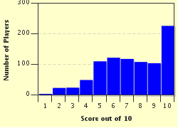
7 / 10
Plays
3364
Awards
Top 20% Quiz
Last 3 plays: Terrirose (5/10), alan56 (9/10), oldgrannyk (7/10).
- -
Question 1 of 10
1. Which strait, lying between Baffin Island and Greenland, is known as Iceberg Alley? Hint


Question 2 of 10
2. Which lake, found in the Northwest Territories of Canada, is the deepest lake in North America? Hint


Question 3 of 10
3. Which major river in Canada was originally called "Disappointment River"? Hint


Question 4 of 10
4. Eggers Island, whose native name is Itilleq, is an uninhabited island whose southernmost point is Cape Farewell. The island is the property of which of the following? Hint


Question 5 of 10
5. This Greenland town's name translates to "great plain" and was settled in 1941 when an American Air Force Base was built here. Hint


Question 6 of 10
6. In 2007 a previously unknown island was uncovered off the coast of Greenland as a glacier retreated inland. What is the English translation of this island's name? Hint


Question 7 of 10
7. If you were visiting an archipelago comprised of eighteen islands located between Iceland and Norway, where would you be? Hint


Question 8 of 10
8. What is the northernmost region of Finland, which extends into the Arctic Circle, also known as? Hint


Question 9 of 10
9. The Isle of Grimsey in the North Atlantic Ocean belongs to which country? Hint


Question 10 of 10
10. The "Tunguska Event" was a 1908 explosion estimated to be 1,000 times more powerful than the bomb dropped on Hiroshima. Where in the world did this occur? Hint


(Optional) Create a Free FunTrivia ID to save the points you are about to earn:

arrow Select a User ID:
arrow Choose a Password:
arrow Your Email:


Most Recent Scores
Nov 10 2024 : Terrirose: 5/10
Nov 03 2024 : alan56: 9/10
Oct 23 2024 : oldgrannyk: 7/10
Oct 07 2024 : Rudd13: 8/10
Sep 29 2024 : BardAsh85: 10/10
Sep 24 2024 : ChunkyWeenie: 7/10

Score Distribution

quiz
Quiz Answer Key and Fun Facts
1. Which strait, lying between Baffin Island and Greenland, is known as Iceberg Alley?

Answer: Davis Strait

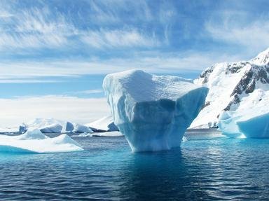
Every year, hundreds of icebergs make their way southward from Baffin Bay, through the narrowing ("alley") of Davis Strait, to the Labrador Sea and eventually, to the Atlantic. It is at the southerly end of this iceberg route where the Titanic sank. Davis Strait also has extremely strong tides that can range between thirty and sixty feet.

It was named after the English explorer John Davis, one of many who sought the Northwest Passage.
2. Which lake, found in the Northwest Territories of Canada, is the deepest lake in North America?

Answer: Great Slave Lake

The "Great Gitchi Gumi" is another name for Lake Superior. Firedrake Lake and Snowbird Lake are located in NWT, but they are of minor geographical significance.

Although it probably took a lot of hard work for European explorers to get there, the history of Great Slave Lake did not really involve unpaid servants. It is named after the indigenous Slavey First Nations group (who call themselves "Dene"). The lake is 2010 feet deep, 300 miles long and between twelve and sixty-eight miles wide, making it the ninth largest lake in the world. Located directly south of Great Slave (and still above the 60th parallel north) is the last remaining natural nesting site in the world for the highly endangered Whooping Crane.
3. Which major river in Canada was originally called "Disappointment River"?

Answer: Mackenzie River

The Mackenzie is one of the largest rivers in the world, it has a discharge of 78 cubic miles of water per annum. It is believed it was called Disappointment by the explorer Alexander Mackenzie, when he was looking for a route to the Pacific and was disappointed when he didn't find it.
4. Eggers Island, whose native name is Itilleq, is an uninhabited island whose southernmost point is Cape Farewell. The island is the property of which of the following?

Answer: Greenland

The Egger Islands and the other minor islands surrounding them have long been known as the Farewell Archipelago. The lower "tail" of Egger Island is named Cape Farewell and juts out into the North Atlantic Ocean and Labrador Sea and lies on the same latitude as Stockholm and the Shetland Islands.
5. This Greenland town's name translates to "great plain" and was settled in 1941 when an American Air Force Base was built here.

Answer: Narsarsuaq

Narsarsuaq offers unparalleled views of Greenland's vibrant green slopes, easily explaining why Erik the Red chose the name Greenland when he settled here. Traces of the Norse inhabitants are clearly visible and as well as a reconstruction of Thjodhild's Church, the first Christian church ever built on the North American continent. Narsaruag is home to South Greenland's International Airport as well.
6. In 2007 a previously unknown island was uncovered off the coast of Greenland as a glacier retreated inland. What is the English translation of this island's name?

Answer: Warming Island

The official name of the island, which translates to Warming Island, is Uunartoq Qeqertaq. As of 2011 Queen Margrethe II is the reigning monarch of Denmark, which Greenland is a part of.

There are over 250 millions tons of icebergs that break off (known as calving) from some the glaciers inhabiting the area, to begin their floating journey . One of these glaciers is the Qoroq Glacier.

The Sermilik fiord, is home to one of the largest glaciers in southern Greenland. The wall of ice that rises behind Sermilik fjord stretches for 1,500 miles from north to south and covers 80% of Greenland and dates to over 3 million years.
7. If you were visiting an archipelago comprised of eighteen islands located between Iceland and Norway, where would you be?

Answer: Faroe Islands

If you've forgotten your woolies at home you can probably get some in the Faroes, as there are at least twice as many sheep as there are people. Summer temperatures are nothing to write home about, rarely getting over 52F (11C). But despite being situated on the 62nd north parallel, winters aren't all that bad, with average temps around 37F (3C).

In fact, it hardly ever falls below freezing there as the islands sit smack dab in the middle of the Gulf Stream drift.
8. What is the northernmost region of Finland, which extends into the Arctic Circle, also known as?

Answer: Lapland

The Gulf of Bothnia borders the Lapland region of Finland. This area is still undergoing post-glacial rebound which causes the land to rise about one cm per year. Lapland has borders with Sweden, Norway and Russia.

One annual event that you can experience in Lapland is the Gold Panning Finnish Open. Modern gold panning competitions began in the Lapland town of Tankavaara in 1974 and have spread to other countries since then.

The Lapland area in the question is the solely the Finnish region, but there is a larger region known as Lapland which covers parts of Norway, Sweden, Finland and the Kola Peninsula of Russia. Ths larger area known as Lapland is home to the Sami people.
9. The Isle of Grimsey in the North Atlantic Ocean belongs to which country?

Answer: Iceland

In 2011 the island had a population of less then 100. Like most areas in the far north, the economy is driven by commerical fishing. For recreation the people of Grimsey Island are known to be avid chess players. Despite the word "Ice" in Iceland, the weather is comparatively mild due to the North Atlantic current bringing warmth from the Gulf of Mexico, which means that you can play chess outdoors for much of the year.

But you won't find any shade as there are no trees on the island - plus, you might have trouble keeping your board clean because of the astonishingly high numbers of bird species! Polar bears have been known to make it to the island after hitching rides on icebergs; one such polar bear that made it to the island was shot in 1969 and now resides as part of the local museum.
10. The "Tunguska Event" was a 1908 explosion estimated to be 1,000 times more powerful than the bomb dropped on Hiroshima. Where in the world did this occur?

Answer: Russia

The center of the blast is located at 60.55N and 101.57E, which puts it near the Podkamennaya Tunguska River in Siberia. Over 80 million trees were destroyed and undetermined numbers of animals living in the taiga forest were killed. All kinds of wild theories from black holes to alien spacecraft have been put forward as the cause of the explosion, but the general scientific consensus is that a piece of a comet or asteroid entered Earth's atmosphere and disintegrated about 30,000 feet above the ground.

There is some speculation due to studies conducted in 2009 that one fragment did not explode and instead may have created Lake Cheko which can be found five miles from the hypocenter.
Source: Author BxBarracuda

This quiz was reviewed by FunTrivia editor spanishliz before going online.
Any errors found in FunTrivia content are routinely corrected through our feedback system.
11/23/2024, Copyright 2024 FunTrivia, Inc. - Report an Error / Contact Us