FREE! Click here to Join FunTrivia. Thousands of games, quizzes, and lots more!
Quiz about European Regions

European Regions Trivia Quiz


In each case I'll give a description of a European Region. Region,in this case is a term that can apply to any geographical, political or cultural area but the question should make it fairly clear.Your just have to tell me where. Couldn't be easier!

A multiple-choice quiz by swbhoy. Estimated time: 8 mins.
  1. Home
  2. »
  3. Quizzes
  4. »
  5. Geography Trivia
  6. »
  7. Europe
  8. »
  9. Europe - Regions

Author
swbhoy
Time
8 mins
Type
Multiple Choice
Quiz #
26,953
Updated
Dec 03 21
# Qns
15
Difficulty
Difficult
Avg Score
6 / 15
Plays
2267
- -
Question 1 of 15
1. I am a region, and official department of France crossed by seven rivers including the River Isle which crosses me from North East to South West. My many, scenic valleys, support varied cultivation including wheat, potatoes, corn and fruit. I am divided into four main administrative regions, one of which is Nontron. Hint


Question 2 of 15
2. Part of the larger Bohemian Massif, I provide some of my nations richest mineral deposits. My main town is Walbrzych but many small resorts and spas are found in my more rural areas. Hint


Question 3 of 15
3. I am a region of North Central Jutland bearing the same name as my principal city. Once the consecration site of Danish Kings, and the site of the first Danish mint, I went into decline after the seat of Danish power moved East. I am now a commercial centre responsible for beer, tobacco, textiles and machinery. Hint


Question 4 of 15
4. I am a common name given to a ridge of limestone hills across the Western Midlands region of England. My escarpment rises steeply from the valley of the lower Severn and slopes gradually towards Oxford. I am one of England's principal tourist regions and the village of Broadway lists among my principal attractions Hint


Question 5 of 15
5. A principality in my own right, my independant status is traditionally ascribed to Charlemagne who recovered my region from invaders in the early 800's. My landmass lies wholly within the Roman Catholic diocese of the 'See of Urgel'. The streams running through my many valleys result in my one main river, the Valira. Hint


Question 6 of 15
6. I am a southern Italian region extending from the Fortore River in the South West to the Cape Santa Maria di Leuca in my North East. I am bordered to the North by the Gargano Promontory and to the West by the Neapolitan Apennines. One of my main urban centres is Foggia. Hint


Question 7 of 15
7. I am a Dutch province that, through historical links, shares a name with a present day Belgian district. I am bordered on the East by Germany and the southern part of my region is unusual in the Netherlands for being relatively hilly. I am drained by the rivers, Geul, Gulp, Roer and the Maas. Hint


Question 8 of 15
8. A northern German province I border at least one other European nation. My state (lander) capital is a major port servicing the Baltic Sea. The loamy soil in my eastern countryside brings the best wheat harvests in Germany. Hint


Question 9 of 15
9. I am a Swiss canton on the border with two other European Nations. Part of my area encompasses the valley of the Upper Rhone river. Originally part of the kingdom of Jurane Burgundy I was granted in 999AD to the bishop of Sion, the town that is still my main administrative centre. Hint


Question 10 of 15
10. I am an area in North Belgium with a long and often bloody history. I am divided into 8 administrative arrondissements including Ostend, Brugge and Ypres. I am Belgium's leading agricultural province while much of my coastal region enjoys a lively tourist trade Hint


Question 11 of 15
11. I am the largest and most northerly of Sweden's lan or counties. I border both Norway and Finland and over 50 percent of my landmass is located within the Arctic Circle. The Western part of my province constitutes part of Lappland. Hint


Question 12 of 15
12. I am an island region of a European nation. History shows that I had been completely uninhabited until around 1427 when I was first discovered by the nation which still governs me today. My main exports are embroideries, pineapples, canned fish and wine. Hint


Question 13 of 15
13. I am a Russian province that shares its name with my main administrative centre. As one of the main crossroads between Russia, Europe and Asia Minor I have long been a trading region of great importance and have been involved in centuries of power struggle with Moscow, in which I often called on the help of Lithuania, my close neighbour. My Kremlin, on the banks of the Volkhov is one of Russia's oldest having been originally built (in wood) in 1044. My main industries are now tourism and the production of chemical fertilizers. Hint


Question 14 of 15
14. I am a county of Southern England bordering the English Channel. A ridge of chalk hills, the South Downs, runs across the county from east to west. My area is divided into two urban (or borough districts) and 5 rural districts which include Adur and Arun. Hint


Question 15 of 15
15. I am a department of modern Greece, located in the south-eastern part of the Peloponnese. My only large rivers are the Evrotas River and its tributary, the Oinous River. My main products are olive oil and citrus fruits which are traded in the historical town of Sparta, my main administrative centre. Hint


(Optional) Create a Free FunTrivia ID to save the points you are about to earn:

arrow Select a User ID:
arrow Choose a Password:
arrow Your Email:


Most Recent Scores
Nov 09 2024 : Guest 5: 5/15
Nov 01 2024 : Guest 159: 4/15

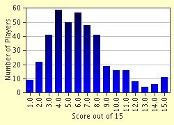
Score Distribution

quiz
Quiz Answer Key and Fun Facts
1. I am a region, and official department of France crossed by seven rivers including the River Isle which crosses me from North East to South West. My many, scenic valleys, support varied cultivation including wheat, potatoes, corn and fruit. I am divided into four main administrative regions, one of which is Nontron.

Answer: Dordogne

The Dordogne region is one of the principal tourist areas of France. Encompassing the ancient region of Perigord,it is home to some of the most striking scenery in the whole of the country.
2. Part of the larger Bohemian Massif, I provide some of my nations richest mineral deposits. My main town is Walbrzych but many small resorts and spas are found in my more rural areas.

Answer: The Sudeten

Sitting close to the borders of both the Czech Republic and Germany, the Sudeten has long been coveted for its rich mineral deposits and has been a centre of industry in SW Poland since the early 1800's.
3. I am a region of North Central Jutland bearing the same name as my principal city. Once the consecration site of Danish Kings, and the site of the first Danish mint, I went into decline after the seat of Danish power moved East. I am now a commercial centre responsible for beer, tobacco, textiles and machinery.

Answer: Viborg

Legend has it King Canute sailed from Viborg on his succesful invasion of England.
4. I am a common name given to a ridge of limestone hills across the Western Midlands region of England. My escarpment rises steeply from the valley of the lower Severn and slopes gradually towards Oxford. I am one of England's principal tourist regions and the village of Broadway lists among my principal attractions

Answer: The Cotswolds

Part of the charm of the Cotswolds is the locally quarried oolithic limestone thats yellow colour adds to the picturesque quality of many of the buildings.
5. A principality in my own right, my independant status is traditionally ascribed to Charlemagne who recovered my region from invaders in the early 800's. My landmass lies wholly within the Roman Catholic diocese of the 'See of Urgel'. The streams running through my many valleys result in my one main river, the Valira.

Answer: Andorra

Although Andorra absorbs influences from both Spain and France, its main character is derived from the Catalan culture. The official language is Catalan and many of its laws and institutions are based on the Catalan model.
6. I am a southern Italian region extending from the Fortore River in the South West to the Cape Santa Maria di Leuca in my North East. I am bordered to the North by the Gargano Promontory and to the West by the Neapolitan Apennines. One of my main urban centres is Foggia.

Answer: Puglia

Puglia produces the strongest of Italy's wines, many of which are used to fortify the weaker varities produced in the north.
7. I am a Dutch province that, through historical links, shares a name with a present day Belgian district. I am bordered on the East by Germany and the southern part of my region is unusual in the Netherlands for being relatively hilly. I am drained by the rivers, Geul, Gulp, Roer and the Maas.

Answer: Limburg

Limburg's principal centre, Maastricht has gone down in history as being the location of the signing of the Treaty on European Union in 1991.
8. A northern German province I border at least one other European nation. My state (lander) capital is a major port servicing the Baltic Sea. The loamy soil in my eastern countryside brings the best wheat harvests in Germany.

Answer: Schleswig-Holstein

Both Schleswig and Holstein have at times been subject to the claims and counterclaims of Denmark, Sweden, the Holy Roman Empire, Prussia, and Austria but the Napoleonic Wars engendered Germanic nationalism that saw the two provinces combine.
9. I am a Swiss canton on the border with two other European Nations. Part of my area encompasses the valley of the Upper Rhone river. Originally part of the kingdom of Jurane Burgundy I was granted in 999AD to the bishop of Sion, the town that is still my main administrative centre.

Answer: Valais

Valais takes its name from the Latin 'Vallis Poenina' literally meaning,'Upper Rhone Valley'.
10. I am an area in North Belgium with a long and often bloody history. I am divided into 8 administrative arrondissements including Ostend, Brugge and Ypres. I am Belgium's leading agricultural province while much of my coastal region enjoys a lively tourist trade

Answer: West Flanders

After devastating damage, especially in WW1, many of West Flanders towns and cities, including Ypres, had to be almost entirely rebuilt.
11. I am the largest and most northerly of Sweden's lan or counties. I border both Norway and Finland and over 50 percent of my landmass is located within the Arctic Circle. The Western part of my province constitutes part of Lappland.

Answer: Norrbotten

Summer in Norrbotten is so short that few crops will grow but the region does have a thriving iron industry.
12. I am an island region of a European nation. History shows that I had been completely uninhabited until around 1427 when I was first discovered by the nation which still governs me today. My main exports are embroideries, pineapples, canned fish and wine.

Answer: The Azores

Before the development of weather satellites, meteorological data compiled and transmitted from the Azores were essential to European weather forecasting
13. I am a Russian province that shares its name with my main administrative centre. As one of the main crossroads between Russia, Europe and Asia Minor I have long been a trading region of great importance and have been involved in centuries of power struggle with Moscow, in which I often called on the help of Lithuania, my close neighbour. My Kremlin, on the banks of the Volkhov is one of Russia's oldest having been originally built (in wood) in 1044. My main industries are now tourism and the production of chemical fertilizers.

Answer: Novgorod

Novgorod is one of the oldest Russian cities, first mentioned in chronicles of 859.
14. I am a county of Southern England bordering the English Channel. A ridge of chalk hills, the South Downs, runs across the county from east to west. My area is divided into two urban (or borough districts) and 5 rural districts which include Adur and Arun.

Answer: West Sussex

Coastal erosion, especially around Selsey Bill, has produced continual changes in the West Sussex shoreline
15. I am a department of modern Greece, located in the south-eastern part of the Peloponnese. My only large rivers are the Evrotas River and its tributary, the Oinous River. My main products are olive oil and citrus fruits which are traded in the historical town of Sparta, my main administrative centre.

Answer: Laconia

Tradition holds that the last Byzantine emperor, Constantine Palaeologus, was crowned in the church of Hagios Demetrios, which still stands at Mistris, just southwest of Sparta.
Source: Author swbhoy

This quiz was reviewed by FunTrivia editor minch before going online.
Any errors found in FunTrivia content are routinely corrected through our feedback system.
11/21/2024, Copyright 2024 FunTrivia, Inc. - Report an Error / Contact Us