FREE! Click here to Join FunTrivia. Thousands of games, quizzes, and lots more!
Quiz about Our Home is Girt By Sea  Australian Waters

"Our Home is Girt By Sea": Australian Waters Quiz


"Our home is girt by sea" is part of our Australian National Anthem. We may be a continent but we are also an island. Come with us as we circumnavigate our homeland clockwise. We commence our journey from the Great Barrier Reef in northeast Australia.

A multiple-choice quiz by 1nn1. Estimated time: 5 mins.
  1. Home
  2. »
  3. Quizzes
  4. »
  5. Geography Trivia
  6. »
  7. Physical Geography
  8. »
  9. Bodies of Water

Author
1nn1
Time
5 mins
Type
Multiple Choice
Quiz #
362,417
Updated
Dec 03 21
# Qns
10
Difficulty
Average
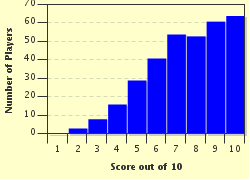
Avg Score
7 / 10
Plays
1529
Awards
Top 5% quiz!
Last 3 plays: Guest 5 (7/10), papabear5914 (6/10), sam388 (10/10).
- -
Question 1 of 10
1. "Our Home is girt by sea" is the fourth line of the Australian National Anthem, "Advance Australia Fair". There has been some criticism of the anthem, particularly surrounding the use of the word, girt, a word not in common usage in Australia. What is a synonym for "girt"? Hint


Question 2 of 10
2. The Great Barrier Reef follows almost the entire length of the Queensland coastline. What is the name of the sea that surrounds this reef? Hint


Question 3 of 10
3. Travelling south, Moreton Bay is the bay at the end of the Brisbane River and covers the coastal region of Brisbane and surrounding areas. Who or what is Moreton Bay named after? Hint


Question 4 of 10
4. When you cross the body of water between Australia and New Zealand (approximately 2200km), you are "crossing the ditch". What is the name of this body of water? Hint


Question 5 of 10
5. Captain Cook named Botany Bay and Port Jackson on his 1770 expedition. When the first fleet landed in New South Wales in 1788, they aimed to settle at Botany Bay but moved to the more suitable Port Jackson (now Sydney) a few days later. In what direction did Captain Phillip have to sail to reach Port Jackson? Hint


Question 6 of 10
6. Bass Strait (named after George Bass, surgeon and explorer), separates the island state of Tasmania from the mainland to the north. There are two large islands (one of them is named after Bass' sailing partner), at either end of the strait. What are their names?
Hint


Question 7 of 10
7. Heading north west now through the Great Australian Bight, the Spencer Gulf, a large water inlet on the southern coast of South Australia, contains the world's only mass breeding area for which unique cephalopod species of marine animal? Hint


Question 8 of 10
8. Heading across the Southern Ocean then turning north along the western seaboard of Western Australia, we come to Fremantle, the port city for the WA capital of Perth. What is the body of water west of Fremantle which includes the off-shore island of Rottnest Island? Hint


Question 9 of 10
9. Melville and Bathurst Islands, known as the Tiwi Islands, are located in this sea, named after a nearby island, north of Darwin. What body of water is it?
Hint


Question 10 of 10
10. As we sail eastward through the Arafura Sea, passing the enormous Gulf of Carpentaria to the south we come to Torres Strait which connects with the Coral Sea in Northern Queensland. This is a narrow (150km), shallow body of water filled with islands (274, of which 17 are permanently settled) which separates Cape York, Queensland, with its nearest neighbour. What is the name of this country which serves as the northern boundary of Torres Strait? Hint


(Optional) Create a Free FunTrivia ID to save the points you are about to earn:

arrow Select a User ID:
arrow Choose a Password:
arrow Your Email:


Most Recent Scores
Nov 21 2024 : Guest 5: 7/10
Nov 03 2024 : papabear5914: 6/10
Nov 01 2024 : sam388: 10/10

Score Distribution

quiz
Quiz Answer Key and Fun Facts
1. "Our Home is girt by sea" is the fourth line of the Australian National Anthem, "Advance Australia Fair". There has been some criticism of the anthem, particularly surrounding the use of the word, girt, a word not in common usage in Australia. What is a synonym for "girt"?

Answer: Surrounded

"Girt" is the past tense and past participle of "gird" which means to surround or hem in. It can also mean to encircle with a belt. To gird your loins is idiomatic to prepare for some sort of action. While "girt" is uncommonly used, any synonym for it is invariably poly-syllabic and therefore does not fit within the song. Advance Australia Fair was written in 1878 by Peter Dodds McCormick (born in Scotland!) and was chosen by the Australian people by plebiscite in 1977, pipping "Waltzing Matilda" and "God Save the Queen".
2. The Great Barrier Reef follows almost the entire length of the Queensland coastline. What is the name of the sea that surrounds this reef?

Answer: Coral Sea

Much of the Coral Sea covers a UNESCO World Heritage Site as the sea is essentially the area that covers the Great Barrier Reef. Nearly all of Queensland's offshore tourist islands are located on the Reef or at least nearby and all are within the Coral Sea. All other options are fictitious names.
3. Travelling south, Moreton Bay is the bay at the end of the Brisbane River and covers the coastal region of Brisbane and surrounding areas. Who or what is Moreton Bay named after?

Answer: Lord Morton, President of the Royal Society (misspelt by Captain Cook)

Moreton Bay was named by Captain James Cook in 1770 after Lord Morton, President of the Royal Society. The spelling of "Moreton" was an error in Cook's record and Queen Victoria did not have a sixth son.
Moreton Bay fig trees and Moreton Bay bugs are named after Moreton Bay.
4. When you cross the body of water between Australia and New Zealand (approximately 2200km), you are "crossing the ditch". What is the name of this body of water?

Answer: The Tasman Sea

The Tasman Sea was named after Dutch explorer Abel Janszoon Tasman, the first recorded European to reach New Zealand (NZ) and Tasmania in 1642. Captain James Cook spent extensive time in the Tasman Sea in his 1770 expedition. There is a ridge halfway between Australia and NZ, where the two land masses were once joined. Hence flying/sailing from Australia to NZ or vice versa means you are "crossing the ditch".
All other names are fictitious.
5. Captain Cook named Botany Bay and Port Jackson on his 1770 expedition. When the first fleet landed in New South Wales in 1788, they aimed to settle at Botany Bay but moved to the more suitable Port Jackson (now Sydney) a few days later. In what direction did Captain Phillip have to sail to reach Port Jackson?

Answer: North

Captain Cook named Botany Bay, "Stingray Bay" after the many stingrays observed in the bay. He changed its name to Botany Bay when shown the variety of botanical specimens collected on its shore. When Captain Phillip arrived on 18 January 1788, he found the sandy soil too infertile to support a settlement so moved a few miles NORTH to the excellent harbour called Port Jackson where Sydney was born.

However Captain Hunter in 1789 found abundant fresh water around Botany Bay so it was settled very early in the 19th century.
6. Bass Strait (named after George Bass, surgeon and explorer), separates the island state of Tasmania from the mainland to the north. There are two large islands (one of them is named after Bass' sailing partner), at either end of the strait. What are their names?

Answer: King Island and Flinders Island

King Island is at the western end and Flinders Island is at the eastern end.
Wednesday and Thursday Islands are in Torres Strait, at the pointy end of Queensland. Heard Island and McDonald Islands are very remote uninhabited islands in the Southern Ocean, and Cockatoo Island and Goat Island are both in Sydney Harbour.

In 1797/8, Bass and Matthew Flinders circumnavigated Van Diemen's Land now Tasmania, proving that Tasmania was not connected to the mainland.
7. Heading north west now through the Great Australian Bight, the Spencer Gulf, a large water inlet on the southern coast of South Australia, contains the world's only mass breeding area for which unique cephalopod species of marine animal?

Answer: Cuttlefish

The Spencer Gulf is 332km long and 129km wide at its mouth. At Point Lowly in the upper Spencer Gulf, the Giant Australian Cuttlefish (Sepia apama) congregates to spawn on the tidal reefs of the Gulf. Cuttlefish possess an internal structure not unlike mammal bone, made from the crystal form of calcium carbonate. This so-called cuttlebone, is porous and provides buoyancy by filling and emptying with gas. This structure is found only in cuttlefish.

The largest towns on the Gulf are Whyalla, Port Augusta and Port Pirie. The Yorke Peninsula separates Spencer Gulf (west) from the Gulf of Saint Vincent (east). South Australia's capital city, Adelaide, resides on the southeastern side of Gulf of Saint Vincent.
8. Heading across the Southern Ocean then turning north along the western seaboard of Western Australia, we come to Fremantle, the port city for the WA capital of Perth. What is the body of water west of Fremantle which includes the off-shore island of Rottnest Island?

Answer: Indian Ocean

The west coast of Western Australia is unique has it as no sea, gulf, or bight along its coast unlike the rest of Australia. Rottnest Gulf, Fremantle Sea and Great Western Bight are all fictitious. Apart from the odd local bay, the west coast faces the Indian Ocean.
9. Melville and Bathurst Islands, known as the Tiwi Islands, are located in this sea, named after a nearby island, north of Darwin. What body of water is it?

Answer: Timor Sea

Melville Island is the second largest Australia island after Tasmania. It lies in the Timor Sea adjacent to Bathurst Island along with reefs, uninhabited islands and hydrocarbon deposits. As result of these deposits the Timor Sea Treaty was signed in 2002 and ratified in 2007 to ensure the division of the proceeds to the petroleum production between East Timor and Australia.
10. As we sail eastward through the Arafura Sea, passing the enormous Gulf of Carpentaria to the south we come to Torres Strait which connects with the Coral Sea in Northern Queensland. This is a narrow (150km), shallow body of water filled with islands (274, of which 17 are permanently settled) which separates Cape York, Queensland, with its nearest neighbour. What is the name of this country which serves as the northern boundary of Torres Strait?

Answer: Papua New Guinea

Papua New Guinea is Australia's nearest neighbour being only 150km across Torres Strait at its narrowest part. This country occupies the eastern part of the island of New Guinea, the western half being the Papua and Western Papua provinces of Indonesia. Most of the 274 islands in the Torres Strait belong to Australia. New Caledonia, a French dependency, is situated at the eastern edge of the Coral Sea. Vanuatu, an independent country (formerly the New Hebrides) is 200km northeast of New Caledonia in the South Pacific Ocean. New Zealand, contrary to popular belief, is not Australia's nearest neighbour.
Source: Author 1nn1

This quiz was reviewed by FunTrivia editor Tizzabelle before going online.
Any errors found in FunTrivia content are routinely corrected through our feedback system.
12/21/2024, Copyright 2024 FunTrivia, Inc. - Report an Error / Contact Us