FREE! Click here to Join FunTrivia. Thousands of games, quizzes, and lots more!
Quiz about Stuck in Ontario Traffic

Stuck in Ontario Traffic Trivia Quiz


Ontario's traffic is notoriously bad. If you were (or are) in the province, here's ten highways you could get stuck on.

A matching quiz by George95. Estimated time: 5 mins.
  1. Home
  2. »
  3. Quizzes
  4. »
  5. World Trivia
  6. »
  7. Transport
  8. »
  9. Roads & Highways

Author
George95
Time
5 mins
Type
Match Quiz
Quiz #
386,571
Updated
Dec 03 21
# Qns
10
Difficulty
Average
Avg Score
7 / 10
Plays
1031
Last 3 plays: Guest 142 (3/10), sabbaticalfire (6/10), dalthor1974 (6/10).
(a) Drag-and-drop from the right to the left, or (b) click on a right side answer box and then on a left side box to move it.
QuestionsChoices
1. It is 102 kilometers between London and Sarnia, ending at the Blue Water Bridge to the United States on this highway.  
  Highway 17
2. Ontario's longest highway and part of the Trans Canada Highway, stretching 1964 km from the Manitoba border to Arnprior.   
  Highway 402
3. This north-south highway provides the link between Toronto and the area collectively known as "cottage country".  
  Gardiner Expressway
4. This route will take you from Toronto to Buffalo, and you can visit the Welland Canal and Niagara Falls along the way.  
  Highway 409
5. This short (5.6 km) Toronto highway connects Highway 401 to Pearson International Airport.  
  Highway 400
6. From this highway in downtown Toronto, you can easily see the CN Tower, Rogers Centre and over Exhibition Place.  
  Highway 405
7. The "General Brock Parkway" ends at the Queenston-Lewiston Bridge to the United States, north of Niagara Falls.   
  Queen Elizabeth Way
8. This highway can take you to Windsor, London, Kitchener, Oshawa, Kingston and Toronto just to name a few...  
  Highway 403
9. A portion of this highway is named the Alexander Graham Bell Parkway as it passes by his long-time home (Wayne Gretzky's too!).  
  Highway 401
10. This cross-town Ottawa expressway will take you over the famed Rideau Canal.  
  Highway 417


Select each answer

1. It is 102 kilometers between London and Sarnia, ending at the Blue Water Bridge to the United States on this highway.
2. Ontario's longest highway and part of the Trans Canada Highway, stretching 1964 km from the Manitoba border to Arnprior.
3. This north-south highway provides the link between Toronto and the area collectively known as "cottage country".
4. This route will take you from Toronto to Buffalo, and you can visit the Welland Canal and Niagara Falls along the way.
5. This short (5.6 km) Toronto highway connects Highway 401 to Pearson International Airport.
6. From this highway in downtown Toronto, you can easily see the CN Tower, Rogers Centre and over Exhibition Place.
7. The "General Brock Parkway" ends at the Queenston-Lewiston Bridge to the United States, north of Niagara Falls.
8. This highway can take you to Windsor, London, Kitchener, Oshawa, Kingston and Toronto just to name a few...
9. A portion of this highway is named the Alexander Graham Bell Parkway as it passes by his long-time home (Wayne Gretzky's too!).
10. This cross-town Ottawa expressway will take you over the famed Rideau Canal.

Most Recent Scores
Dec 18 2024 : Guest 142: 3/10
Nov 29 2024 : sabbaticalfire: 6/10
Nov 24 2024 : dalthor1974: 6/10
Nov 21 2024 : Upstart3: 10/10
Nov 02 2024 : Guest 165: 0/10

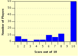
Score Distribution

quiz
Quiz Answer Key and Fun Facts
1. It is 102 kilometers between London and Sarnia, ending at the Blue Water Bridge to the United States on this highway.

Answer: Highway 402

Highway 402 runs in a near straight line from London to Sarnia so the construction of the highway would not disrupt any farm plots. The Blue Water Bridge was built in 1938, a divided highway link to London came in the years following the Second World War, but the connection to Highway 401 was not completed until 1982.

Originally a four lane highway, it has been expanded to six lanes in Sarnia due to traffic caused by the American border crossing. Across the bridge into Michigan, the highway intersects with Interstates 69 and 94.
2. Ontario's longest highway and part of the Trans Canada Highway, stretching 1964 km from the Manitoba border to Arnprior.

Answer: Highway 17

Public sentiment was high in the 1920s for a trans-Canada highway, and planning was soon done to route it through northern Ontario. The federal government established highway camps as part of the Great Depression relief plan to construct these highways through these isolated areas.

The project lost funding due to conflict, and the outbreak of World War II moved attention elsewhere. A 500 kilometre gap in the highway, known as "The Gap" was filled in in the 1950s. In Arnprior, the route becomes Highway 417, a divided lane highway into Ottawa and then on towards the Quebec border and Montreal.
3. This north-south highway provides the link between Toronto and the area collectively known as "cottage country".

Answer: Highway 400

Highway 400 was designated on Canada Day, 1952 as a four-lane divided highway from Toronto to Barrie. From Barrie, further extensions were built along Highway 69 to Port Severn and then Parry Sound. Highway 400 is the major thoroughfare to "cottage country", where much of the residents of Toronto and its suburbs have summer cottages, trailers or campsites. On Friday afternoons of summer weekends, the 400 tends to be congested with "cottage country traffic".
4. This route will take you from Toronto to Buffalo, and you can visit the Welland Canal and Niagara Falls along the way.

Answer: Queen Elizabeth Way

The QEW as it is known, runs 139 km around the western and southern edge of Lake Ontario. When it opened in 1937, it was the first inter-city divided highway in North America. The road was dedicated to Queen Elizabeth The Queen Mother, and was formerly done in 1939 when she toured Canada with her husband King George VI.

A trip down the highway includes trips over the large Burlington Skyway (over Hamilton Harbour) and Garden City Skyway (over the Welland Canal). One final bridge over the Niagara River from Fort Erie to Buffalo connects the southern terminus of the QEW to the United States.
5. This short (5.6 km) Toronto highway connects Highway 401 to Pearson International Airport.

Answer: Highway 409

Highway 409 serves as a spur route from Highway 401 through Etobicoke. Near Pearson Airport, the highway intersects with Highway 427. Original plans were for the Highway 409 to bypass the airport to the north and travel towards Brampton, but residents in Malton protested the move.

The Greater Toronto Airport Authority purchased the portion of the highway west of Highway 427 into the airport to adjust lanes into the airport. Despite the small length of the highway, the city crosses city boundaries, meaning it has two different speed limits and police forces patrolling the highway.
6. From this highway in downtown Toronto, you can easily see the CN Tower, Rogers Centre and over Exhibition Place.

Answer: Gardiner Expressway

Unlike the other highways in this quiz, the Gardiner Expressway is municipally owned by the City of Toronto. Much of the Gardiner is elevated above ground, with Highway 2 running parallel underneath. The highway is named after Frederick Gardiner, the first chair of Metropolitan Toronto (before it was the City of Toronto), who campaigned for it among other highways to be built.

The highway was built in the late 1950s and early 1960s, and has been the cause of safety concern for infrequent falls of concrete from the elevated surface to the city streets below.

The highway runs along the lakeshore of Toronto from the QEW/427 junction in the west to the Don Valley Parkway in the East.
7. The "General Brock Parkway" ends at the Queenston-Lewiston Bridge to the United States, north of Niagara Falls.

Answer: Highway 405

The highway is only 8.7 km long from the Queenston-Lewiston Bridge over the Niagara River back to the Queen Elizabeth Way. Only one interchange is available. The highway is named in commemoration of Sir Isaac Brock, who died in the Battle of Queenston Heights in the War of 1812. Both the bridge and the highway were built at the same time opening in 1962-63.

The bridge from Queenston, Ontario to Lewiston, New York is one of three bridges across the Niagara River along with the Fort Erie-Buffalo Peace Bridge and Niagara Falls-Niagara Falls Rainbow Bridge.
8. This highway can take you to Windsor, London, Kitchener, Oshawa, Kingston and Toronto just to name a few...

Answer: Highway 401

Highway 401 is the busiest highway corridor in North America. It runs 828 kilometers from the Ontario-Michigan border in Windsor to the Ontario-Quebec border just south of Montreal. At its largest point in Toronto, the highway has 18 lanes. The highway originated in Toronto and was constructed in stages, finalized in 1968.

The highway has been dedicated the Macdonald-Cartier Freeway, after John A Macdonald and George-Etienne Cartier, two Canadian Fathers of Confederation. Along the highway, 19 service centres are open offering fast food restaurants, coffee shops, gas stations and a place to stretch your legs while on a long drive.
9. A portion of this highway is named the Alexander Graham Bell Parkway as it passes by his long-time home (Wayne Gretzky's too!).

Answer: Highway 403

Highway 403 spans 125 kilometers from Mississauga to Woodstock, where it connects to the 401 at both ends. In Hamilton, the highway climbs the Niagara Escarpment. In 2016, the stretch of the highway from Burlington to Woodstock was dedicated in honour of Alexander Graham Bell, the inventor of the telephone. Bell moved to Canada at the age of 23, and did much of the work in inventing the telephone from his own home in Brantford.

The highway also passes the Square One Shopping Centre in Mississauga, which is Canada's second largest shopping mall.
10. This cross-town Ottawa expressway will take you over the famed Rideau Canal.

Answer: Highway 417

The Queensway, as the 417 is also referred to, was part of the Grenier Plan for rearranging Ottawa's street and rail network after World War II. The road was constructed and opened in stages, with the final portion opening in 1966. In preparation of the 1976 Montreal Summer Olympics, the highways is extended to the east to the Quebec border. Ottawa is connected to the rest of the 400-series network by the 416, which runs south from Ottawa to the 401. Highway 417 has been extended along Highway 17 to the east in stages, prompting some discussion.

The Queensway is no longer used on any signage to describe the highway.
Source: Author George95

This quiz was reviewed by FunTrivia editor stedman before going online.
Any errors found in FunTrivia content are routinely corrected through our feedback system.
Related Quizzes
This quiz is part of series FT Amazing Race 3:

Here is a list of the quizzes written by my team, Last Ones In, for the third edition of FT's legendary quiz authoring race.

  1. Ode to a Boogeyman Average
  2. 'Amazing' Songs Average
  3. Cheeses of the World, Unite! Easier
  4. Flora Prima Donnas Easier
  5. The Prized Scallop Average
  6. The Gargantuan Gaur Average
  7. It Was the Best of Rhymes Average
  8. Canada In the 1960s Average
  9. The Battles of Ancient Greece Easier
  10. The Hustle Bustle of 2016 Average
  11. Word Marathon Very Easy
  12. Sarong Feels So Right Easier

12/21/2024, Copyright 2024 FunTrivia, Inc. - Report an Error / Contact Us