FREE! Click here to Join FunTrivia. Thousands of games, quizzes, and lots more!
Quiz about Vietnam War Places

Vietnam War Places Trivia Quiz


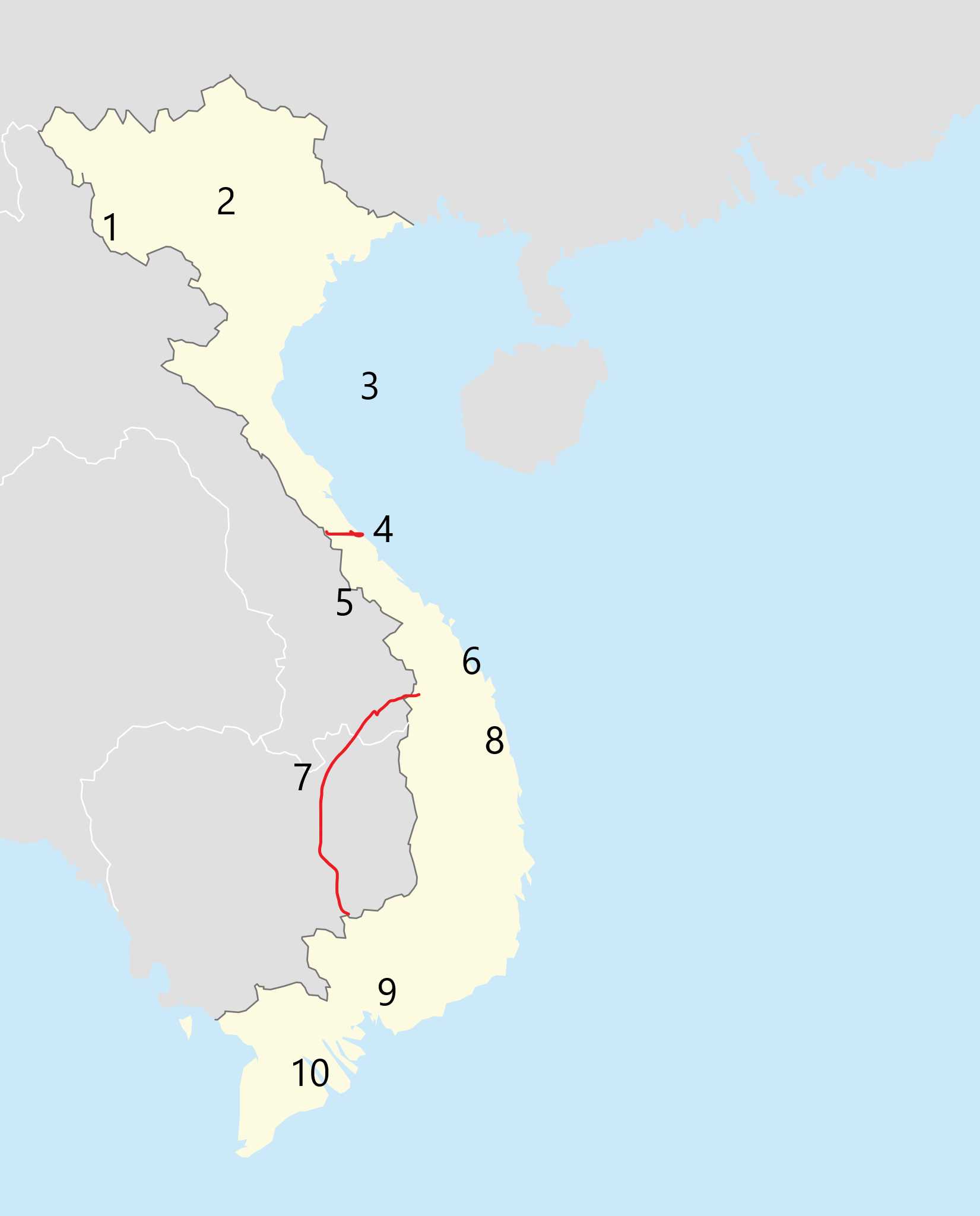
If you watched the nightly news, or read the newspapers, in the 1960s and '70s, many of these place names will be familiar. But do you know where they are?
This is a renovated/adopted version of an old quiz by author ion

A label quiz by looney_tunes. Estimated time: 3 mins.
  1. Home
  2. »
  3. Quizzes
  4. »
  5. Geography Trivia
  6. »
  7. Asia
  8. »
  9. Vietnam

Author
looney_tunes
Time
3 mins
Type
Label Quiz
Quiz #
14,622
Updated
Dec 23 23
# Qns
10
Difficulty
Average
Avg Score
8 / 10
Plays
236
Awards
Top 20% Quiz
Last 3 plays: magijoh1 (8/10), scottm (10/10), Guest 14 (8/10).
Click on image to zoom
Dien Bien Phu Khe Sanh Ho Chi Minh Trail (portion) Da Nang DMZ Saigon My Lai Mekong Delta Hanoi Gulf of Tonkin
* Drag / drop or click on the choices above to move them to the answer list.
1.   
2.   
3.   
4.   
5.   
6.   
7.   
8.   
9.   
10.   

Most Recent Scores
Dec 23 2024 : magijoh1: 8/10
Dec 21 2024 : scottm: 10/10
Dec 07 2024 : Guest 14: 8/10
Nov 25 2024 : Guest 136: 10/10
Nov 14 2024 : Guest 193: 10/10
Nov 12 2024 : Guest 91: 10/10
Nov 10 2024 : Guest 45: 10/10
Nov 07 2024 : Guest 91: 10/10

Quiz Answer Key and Fun Facts
1. Dien Bien Phu

Dien Biên Phu was the site of the battle in 1954 which led to the end of the First Indochina War, and the signing of the 1954 Geneva Accords which split Vietnam into two separate countries. Ho Chi Minh, leader of the Viet Minh forces, took control of the northern part (the Democratic Republic of Vietnam), while the southern part (the State of Vietnam) was declared to be ruled by the emperor. While the First Indochina War was ostensibly between the French colonial rulers and the Vietnamese people who wanted to control their own destiny, it was also steeped in Cold War politics, with the United States providing significant support (military and financial) to the French, while the Soviet Union and the People's Republic of China supported the Viet Minh.

Dien Biên Phu is located in the extreme northwest of the country of Vietnam, and its distance from logistical support centres was one of the decisive aspects of the 1954 battle. In the 1950s, the region was known as a source of opium (good for French income, which made it a key spot for them) and rice.
2. Hanoi

After the partition of Vietnam, the city of Hanoi (Vietnam's second-largest city) became the capital of the Democratic Republic of Vietnam, more commonly referred to as North Vietnam. The city is located on the Red River Delta, about 100 km from the coastal port of Haiphong.

The name Hanoi, meaning "inside the rivers" was made official in 1831; previously it had a number of other names, such as Long Dho (Dragon's Belly), Dai La (Big Net), and Dông Kinh (Eastern Capital).
3. Gulf of Tonkin

The Gulf of Tonkin got its name from one of the titles given to Hanoi, Dông Kinh, meaning Eastern Capital. This arm of the South China Sea borders the east coast of Vietnam north of Ḥn La Island, and is bounded on the north and east by Chinese territories. It forms an important maritime link between the northern part of Vietnam and the rest of the world.

The Gulf of Tonkin became a household name following the Gulf of Tonkin Incident in 1964. This was a confrontation between covert American forces and the North Vietnamese. The Americans blamed the North Vietnamese for it, although it later became clear that they had actually invaded territorial waters (and another later incident never actually happened). The publicity helped gain public support for a larger, and more visible, presence of American troops in the region, and the subsequent Gulf of Tonkin Resolution gave President Johnson the authority to use American troops to support any country in southeast Asia which was threatened by communism. And the escalation began.
4. DMZ

When the Geneva Accords established a border between the northern and southern parts of Vietnam at the 17th parallel, a zone about five miles wide was set up as a Demilitarized Zone (DMZ), providing a buffer between the two states. The DMZ is actually somewhat south of the parallel for most of its length, because natural features that made sense were used. Starting at the border with Laos, it ran roughly east until it picked up the course of the Ben Hai River, following that to its mouth on the coast at the 17th parallel.

While the DMZ was in theory free of combatants, in practice there was a lot of infiltration by both sides. When Vietnam was reestablished as a single nation in 1976, the DMZ ceased to exist (unlike the Korean DMZ, which was established in 1953, and still separated the two antagonistic parts of that country 70 years later).
5. Khe Sanh

Khe Sanh Combat Base, located north of the city of that name, was established as a base for the US Marines in 1962, with the purpose of monitoring for incursions from North Vietnamese troops across the DMZ. Being close to the border, it was a regular target for attacks, including the 1968 Battle of Khe Sanh, which occurred between 21 January and 9 July.

Although the siege was broken (so claimed as a success by the Americans), the base was abandoned shortly afterwards, leading to the North Vietnamese to also claim it as a victory. There is also disagreement about the relationship of this battle with the Tet Offensive at the same time; US General Westmoreland held that the Tet Offensive was intended to distract attention and troops from Khe Sanh, while most historians now consider that Khe Sanh was placed under siege to keep US forces from noticing the buildup of North Vietnamese troops near Saigon.
6. Da Nang

Da Nang is an important port city near the centre of Vietnam (roughly midway between Hanoi and Ho Chi Minh City), first established at the mouth of the Hàn River when the region was part of the Champa empire that occupied most of southern and central Vietnam from around 200 CE until they were conquered by the Vietnamese in 1832, ending a long-running conflict. It was the point from which the French established French Indochina in the middle of the 19th century. In June of 1965, following the Gulf of Tonkin Resolution, US troops arrived in Da Nang to defend the air base there. By December there were 200,000 troops, and Da Nang had become a major air base.

The air base was massively busy moving troops and armaments, handling thousands of flights a day at its peak. The withdrawal of a residual force from the base on 13 August 1972 marked the end of US ground combat in Vietnam, although they continued to provide logistical assistance to the South Vietnamese. (This means there were soldiers there, but technically offering advice and training, not fighting.)
7. Ho Chi Minh Trail (portion)

This was not actually a single entity, but a network of roads, tunnels and trails used to transport people and equipment between North and South Vietnam during the war. It ran through neighbouring Laos and Cambodia. Consolidation of older transport routes began in 1959, when Ho Chi Minh's troops invaded Laos. Use of this network allowed the North Vietnamese to dispatch and support troops in the southern part of Vietnam without having to fight their way past the South Vietnamese army.

In an effort to curtail movement along the trail, US forces conducted extensive bombing raids, and sprayed the ground with Agent Orange, a defoliant that was hoped to remove cover that sheltered those using the network. Despite some success, the movement of troops and equipment along the Ho Chi Minh Trail played a significant role in the fall of Saigon in 1975, which marked the end of the conflict.
8. My Lai

My Lai was one of a number of small villages that were virtually unknown (aside from those who lived there) before US soldiers, frustrated at trying to eliminate enemy troops who were moving freely in the region, and hiding in the villages, decided to destroy the villages to remove the concealment they were providing. What followed became known as the My Lai Massacre, one of the most notorious war crimes committed by US troops during the 20th century.

The savage killing of villagers, on the pretext that if they weren't the enemy, they were helping the enemy, was photographed and seen around the world. The armed forces initially attempted to cover it up, saying that a few civilians had been caught in a military action, but the full scope of the massacre eventually became clear, and a number of the perpetrators faced a court martial. Only one man was convicted, a result which many saw as confirming suspicion that US soldiers were not being discouraged from killing civilians; there may well have been many more massacres that did not receive the same notoriety as My Lai.
9. Saigon

Because this quiz is about Vietnam War sites, I have used the name that was then used for Vietnam's largest city, now known as Ho Chi Minh City. Saigon was the capital of French Indochina from 1945 until 1954, at which time it became the capital of South Vietnam. In 1975, with the fall of Saigon Vietnam once more became a single country, and the city was renamed in honour of the man who had inspired the Vietnamese to rise against the French colonial rule, and led the struggle to reunite the nation. Locals still refer to the centre of the city as Saigon.

Saigon's location traffic routes connecting Vietnam, Cambodia and Thailand (known as Siam when the city was growing) and its selection to be the site of the royal palace for the Nguyen dynasty in the 18th century led to its development as a major settlement. It grew further from the mid-19th century under French control - their architectural legacy can still be seen.
10. Mekong Delta

A large part of the land region of what was known as South Vietnam between 1955 and 1975 is occupied by the Mekong Delta. The Mekong River is the third-longest Asian river, running generally southwards from the Tibetan Plateau through China, Myanmar, Laos, Thailand and Cambodia before entering southern Vietnam and reaching the South China Sea.

Most of the wide-fanning delta is in Vietnam, and its fertility has made it one of the most intensively farmed regions in the country. As such, it has been fought over by neighbouring powers through much of the time since it was first settled, at least as long ago as the fourth century BCE.

During the Vietnam War, the Mekong Delta was the site for a number of battles between Viet Cong and US troops. 1975 saw it used to launch the invasion leading to the fall of Saigon.
Source: Author looney_tunes

This quiz was reviewed by FunTrivia editor agony before going online.
Any errors found in FunTrivia content are routinely corrected through our feedback system.
12/25/2024, Copyright 2024 FunTrivia, Inc. - Report an Error / Contact Us