FREE! Click here to Join FunTrivia. Thousands of games, quizzes, and lots more!
Quiz about Canadian Provinces for Kids

Canadian Provinces for Kids Trivia Quiz


Canada has ten provinces and three territories. This quiz will ask questions about only the provinces, starting with the one that is furthest west and heading to the one that is furthest east. Photo clues are given.

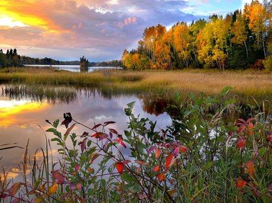
A photo quiz by Trivia_Fan54. Estimated time: 2 mins.
  1. Home
  2. »
  3. Quizzes
  4. »
  5. For Children Trivia
  6. »
  7. Our World for Kids
  8. »
  9. Canadian Geography for Kids

Author
Trivia_Fan54
Time
2 mins
Type
Photo Quiz
Quiz #
408,230
Updated
Feb 23 22
# Qns
10
Difficulty
Very Easy
Avg Score
9 / 10
Plays
573
Last 3 plays: Guest 208 (9/10), kented (9/10), lones78 (9/10).
-
Question 1 of 10
1. The capital of British Columbia (BC) is Victoria, located on Vancouver Island. How do you get your car to or from the island? Hint


Question 2 of 10
2. Alberta is one of Canada's prairie provinces. What is the landscape like in most of the prairies? Hint


Question 3 of 10
3. Where did the name "Saskatchewan" come from?


Question 4 of 10
4. How many lakes are there in the province of Manitoba? There are probably many, many more than you think! Hint


Question 5 of 10
5. What city in Ontario has the beautiful Horseshoe Falls? Hint


Question 6 of 10
6. The province of Quebec lies on the Canadian Shield. What is the Canadian Shield mostly made of? Hint


Question 7 of 10
7. The Reversing Falls is in New Brunswick where the falls flow up and down in two different directions each day. What causes this? Hint


Question 8 of 10
8. Cape Breton is part of Nova Scotia. Is it a large island?


Question 9 of 10
9. What colour is the sand on many beaches in Prince Edward Island? Hint


Question 10 of 10
10. What shape is the island of Newfoundland most like? Hint


Most Recent Scores
Jan 18 2025 : Guest 208: 9/10
Jan 16 2025 : kented: 9/10
Jan 15 2025 : lones78: 9/10
Jan 07 2025 : marianjoy: 8/10
Jan 06 2025 : Guest 208: 7/10
Dec 27 2024 : shvdotr: 9/10
Dec 13 2024 : Guest 99: 8/10
Dec 12 2024 : glenjue: 9/10
Dec 11 2024 : Guest 24: 7/10

Quiz Answer Key and Fun Facts
1. The capital of British Columbia (BC) is Victoria, located on Vancouver Island. How do you get your car to or from the island?

Answer: By ferry

British Columbia (BC) has a lot of ferries. Most of them travel between Vancouver Island and the mainland in southern BC, but there are also some that service smaller islands in the north. The Strait of Juan de Fuca lies between the southern portion of Vancouver Island and mainland Canada and the United States. Ferries are used to carry vehicles across the strait each day. Travellers simply drive onto the lower decks of the boats so that they are facing their destination. The ferry then takes them across the water where they simply drive off because they are headed in the right direction. The process is then reversed to travel back in the other direction.

Victoria is the capital of BC, but it is not the largest city. That is Vancouver, BC that sits across the strait from the island. Having two large and important cities across from one another may explain why the BC ferries are very busy each day.
2. Alberta is one of Canada's prairie provinces. What is the landscape like in most of the prairies?

Answer: Flat

Alberta is a province that changes from mountains on its far western edge, to foothills, then very quickly into prairie land. Most of the province is made up of prairie land. The prairies are mostly flat with very few trees. Farming is very popular in Alberta where ranchers have beef cattle, and farmers grow crops like wheat, barley, oats, and canola.
3. Where did the name "Saskatchewan" come from?

Answer: An indigenous word

The province of Saskatchewan has a major river that runs through it from west to east called the Saskatchewan River. It is about 1,939 kilometres (1,205 miles) long and stretches across the Canadian prairies. The Cree native people of the prairies named it "Kisiskatchewanisipi" or "swift-flowing river".

It was noted on a map from 1760 as the "Kish-stock-ewen" river. That sounded like "Saskatchewan", which is the name that was chosen for the area in 1895. When the area became an official province in 1905, the name became the official name of the province.
4. How many lakes are there in the province of Manitoba? There are probably many, many more than you think!

Answer: Over 110,000

Manitoba is in the centre of Canada. It is the easternmost prairie province, and is home to over 110,000 freshwater lakes! The lakes in Manitoba cover about 15.6% of the surface area of the province. The largest lake in the province is Lake Winnipeg, which is the sixth largest freshwater lake in Canada.
5. What city in Ontario has the beautiful Horseshoe Falls?

Answer: Niagara Falls

The city of Niagara Falls, Ontario shares the Horseshoe Falls with the state of New York in the United States (US). The falls were formed at the end of the last ice age as the glaciers melted. There are actually three falls that make up Niagara Falls - the Horseshoe Falls (pictured), and the American and Bridal Veil Falls, both of which lie in the US.

The Horseshoe Falls are the most powerful falls in North America as measured by the amount of water that passes from them at their base.
6. The province of Quebec lies on the Canadian Shield. What is the Canadian Shield mostly made of?

Answer: Rocks

Over 95% of the province of Quebec lies in the Canadian Shield. The Canadian Shield covers a huge area and extends from Greenland in the east, to northeastern Alberta in the west, and Canada's northern territories in the north, down to parts of the northern US in the south.

The Canadian Shield is over 3.96 billion years old, and is made up of hard rocks that were exposed by the glaciers during the ice age. Now, the rocks form rolling hills that are covered with thin layers of dirt that can support some plants in the north, as well as some trees in the south.
7. The Reversing Falls is in New Brunswick where the falls flow up and down in two different directions each day. What causes this?

Answer: The high tides in the Bay of Fundy

The St. John River travels through New Brunswick (NB) and empties into the Bay of Fundy. The Bay of Fundy has the highest tides in the world, with tides that can reach 16 meters, or 53 feet. The Reversing Falls is actually a series of rapids on the river in the city of St. John, NB.

When the tide is low, the flow of the river is out toward the bay. However when the tide is high, the water is forced up the river from the Bay of Fundy into the river. This causes the flow of the river to be reversed in the other direction.

When the reversed water travels over the rapids, the falls go from flowing down in one direction to flowing down in the other direction.
8. Cape Breton is part of Nova Scotia. Is it a large island?

Answer: Yes

Cape Breton is a large island on the east end of the province of Nova Scotia. It is about 100 km wide and 150 km long. This means that it is over 10,300 square kilometres (3,900 sq mi). To get to Cape Breton Island from the mainland part of Nova Scotia, drivers travel along a causeway. The causeway is a road that is built on top of a pile of rocks that is 1,385 m (4,544 ft) long.
9. What colour is the sand on many beaches in Prince Edward Island?

Answer: Red

Prince Edward Island is the smallest province in Canada. It can be found north of Nova Scotia and east of New Brunswick. Much of the soil on the island has a very high iron content. When the damp iron in the soil is exposed to the air, it rusts and causes the soil to turn red. This happens both inland, and on beaches where the sand is damp much of the time.
10. What shape is the island of Newfoundland most like?

Answer: Triangle

The province of Newfoundland and Labrador is Canada's easternmost province. Labrador is the portion of the province that is on the mainland of Canada, east of Quebec. Newfoundland is the island portion of the province. It is roughly shaped like a triangle, with the sides each being about 500 km (310 mi) long.

The entire area of Newfoundland takes up 111,390 square kilometres (43,010 sq mi). The Strait of Belle Isle lies between Newfoundland and Labrador. It ranges from 15 km (9.3 mi) to 60 km (37.3 mi) wide, and can only be crossed by ferries and other boats.

There are no bridges or tunnels between Newfoundland and the mainland.
Source: Author Trivia_Fan54

This quiz was reviewed by FunTrivia editor MotherGoose before going online.
Any errors found in FunTrivia content are routinely corrected through our feedback system.
Related Quizzes
1. "O Canada" or "No Canada"? Very Easy
2. The Country of Canada for Kids Easier
3. A Very Canadian Quiz Easier
4. Down Your Way Average
5. Canadian Cities Easier
6. Cool Canada Easier
7. A Quiz About Canada Average
8. That's South America! Easier
9. Red, Yellow, or White? Average
10. Let's Travel! Very Easy
11. Earth Quiz for Kids Very Easy
12. A Journey Around the World Easier

1/22/2025, Copyright 2025 FunTrivia, Inc. - Report an Error / Contact Us