FREE! Click here to Join FunTrivia. Thousands of games, quizzes, and lots more!
Quiz about Famous Lines not quotes actual lines in history

Famous Lines (not quotes, actual lines in history) Quiz


This is a quiz about lines that have historical and/or geographic significance.

A multiple-choice quiz by malidog. Estimated time: 4 mins.
  1. Home
  2. »
  3. Quizzes
  4. »
  5. History Trivia
  6. »
  7. Mixed Bag
  8. »
  9. Random History Mix

Author
malidog
Time
4 mins
Type
Multiple Choice
Quiz #
385,560
Updated
Dec 03 21
# Qns
10
Difficulty
Average
Avg Score
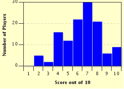
7 / 10
Plays
621
Awards
Top 20% Quiz
Last 3 plays: Johnmcmanners (10/10), Guest 76 (6/10), jr43 (3/10).
- -
Question 1 of 10
1. In which war was there a key defensive position known as the Maginot Line? Hint


Question 2 of 10
2. "Fifty-four Forty or Fight!" was a political slogan in the mid 19th century, demanding that the Pacific Northwest of the United States continue up to the 54th parallel (or line of latitude). Did the contiguous U.S. end up including all the land up to the 54th parallel? Hint


Question 3 of 10
3. Which of the following has NOT been referred to as the "Green Line"? Hint


Question 4 of 10
4. The Mason-Dixon line was an important line in 19th century U.S., marking the line between north and south. Most of the Mason-Dixon line forms the border between which two U.S. states? Hint


Question 5 of 10
5. The Treaty of Tordesillas signed in 1494 established what important line in history? Hint


Question 6 of 10
6. There are a series of lines that are approximately 2,000 years old, carved in various shapes in the high plateau in southern Peru. What are they called? Hint


Question 7 of 10
7. The Prime or Greenwich Meridian (0 degrees longitude) is a line that passes through all of the following countries except which one? Hint


Question 8 of 10
8. There are a number of islands in the world that have a line down the middle of them, splitting them into two separate countries? Which of the following islands is NOT split? Hint


Question 9 of 10
9. During the Cold War, which German city was split in two, with a line down the middle of it? Hint


Question 10 of 10
10. Following the D-Day invasion at Normandy in WWII, the allies quickly advanced up to a line that ran north/south, roughly along the Roer River. A surprise German offensive in late 1944 created a protrusion in this line, and this protrusion ultimately gave the battle its name. What was the name of this battle? Hint


(Optional) Create a Free FunTrivia ID to save the points you are about to earn:

arrow Select a User ID:
arrow Choose a Password:
arrow Your Email:


Most Recent Scores
Today : Johnmcmanners: 10/10
Jan 14 2025 : Guest 76: 6/10
Jan 09 2025 : jr43: 3/10
Dec 31 2024 : Guest 173: 9/10
Dec 18 2024 : konamomholly: 6/10
Dec 08 2024 : Vrijdag2012: 5/10

Score Distribution

quiz
Quiz Answer Key and Fun Facts
1. In which war was there a key defensive position known as the Maginot Line?

Answer: WW II

Named after the French Minister of War, André Maginot, the Maginot Line was a line of concrete fortifications, obstacles and weapon installations that France constructed on the French side of its borders with Switzerland, Germany and Luxembourg during the 1930s.

It was a classic example of "fighting the last war", since it was designed in anticipation of the kind of defensive, trench warfare that marked WWI. What it didn't anticipate was the extensive use of the tank and aircraft in warfare that marked WWI. German tanks sped around, and over, the Maginot line, and German aircraft simply flew over it.
2. "Fifty-four Forty or Fight!" was a political slogan in the mid 19th century, demanding that the Pacific Northwest of the United States continue up to the 54th parallel (or line of latitude). Did the contiguous U.S. end up including all the land up to the 54th parallel?

Answer: No, just to the 49th parallel

In the mid 19th century, expansion of the U.S. to the Pacific, and as far north as possible, was very politically popular. It was the belief that it was the "manifest destiny" of the U.S. to dominate North America. In the 1844 election of James Polk, "54 40 or fight" was a key campaign slogan.

But the outbreak of the Mexican American War in 1846 quickly took focus off the Pacific Northwest, and the border was reset to the 49th parallel.
3. Which of the following has NOT been referred to as the "Green Line"?

Answer: A pest-exclusion fence separating northern Namibia from the rest of the country

The pest exclusion fence in Namibia is called the Red Line. It separates commercial farms in the south mostly owned by whites, with more communal farmland in the north where livestock is not constrained by fences and often ventures onto roads. The red line is a highly guarded line and has roadblocks to check every vehicle which passes. All the other choices were, in fact, called the "Green Line".
4. The Mason-Dixon line was an important line in 19th century U.S., marking the line between north and south. Most of the Mason-Dixon line forms the border between which two U.S. states?

Answer: Maryland and Pennsylvania

The history of the Mason-Dixon line goes back before the American revolution. There was a border dispute between the colonies of Maryland and Pennsylvania, which could have possibly ended up with Philadelphia becoming part of Maryland. This dispute led to Cresap's War in the 1730s between Maryland and Pennsylvania. Two surveyors - Charles Mason and Jeremiah Dixon - resolved the border dispute and the line now forms parts of the borders between Maryland, Pennsylvania, West Virginia, and Delaware. I always found it interesting that while the line places Maryland in "the South", Maryland was a free state and firmly with the Union side during the Civil War.
5. The Treaty of Tordesillas signed in 1494 established what important line in history?

Answer: The line of demarcation between Spanish and Portuguese lands

Once Columbus claimed land in the New World for Spain, a dispute arose with Portugal as to territorial claims for newly discovered lands. The resulting negotiation, and the participation of the Pope in this dispute between two Catholic countries, resulted in drawing a line of demarcation between any future Portuguese and Spanish lands.

This line is the reason why most of South America was colonized by Spain, while Brazil is the only part that was held by Portugal.
6. There are a series of lines that are approximately 2,000 years old, carved in various shapes in the high plateau in southern Peru. What are they called?

Answer: The Nazca Lines

The lines were created by the Nazca culture by carving trenches into the hard desert plateau. The remarkable thing about these lines is how large and extensive they are - the Nazca lines cover an area of 450 sq km or 170 sq mi, and the largest figures can span nearly 1,200 ft (370 m).

The figures include trees, animals and some various geometric shapes. They have remained intact for so long because the desert has a climate that varies very little of the course of the year, is very dry, and virtually windless.
7. The Prime or Greenwich Meridian (0 degrees longitude) is a line that passes through all of the following countries except which one?

Answer: Morocco

The line just misses Morocco, passing through Algeria, just to the east of Morocco. The prime meridian was selected as a global standard in 1884 at a conference in Washington D.C., held at the request of U.S. President Chester A. Arthur. It was necessitated in large part because of the explosion of rail travel, and the need to standardize times between cities. France initially held out and didn't accept the Greenwich meridian at the U.K. Royal Observatory, desiring a more "neutral" location. They did not want one placed in, and named after, their historic rival.
8. There are a number of islands in the world that have a line down the middle of them, splitting them into two separate countries? Which of the following islands is NOT split?

Answer: Crete

Crete is all part of Greece. Hispaniola is separated into Haiti and the Dominican Republic. Tierra del Fuego is actually several islands, at the southern tip of South America, split between Chile and Argentina. Cyprus is a complicated story. While nominally all governed by the Republic of Cyprus, a separate Turkish Cypriot state was established in the north eastern part of the island in 1983.

This continues to be controversial, with Turkey alone recognizing this separate state. But in reality, the island is split.
9. During the Cold War, which German city was split in two, with a line down the middle of it?

Answer: Berlin

When WWII ended and Germany was partitioned into four zones, Berlin had a special status. Though located geographically in the Soviet Zone, it was divided into four sectors, run by France, U.K., the U.S., and the Soviet Union respectively. But in 1948, the Soviet Union blocked movement between East and West Berlin, ultimately dividing it with the Berlin Wall in 1961.

In 1989 the Berlin Wall came down and Berlin, as well as all Germany, were reunited.
10. Following the D-Day invasion at Normandy in WWII, the allies quickly advanced up to a line that ran north/south, roughly along the Roer River. A surprise German offensive in late 1944 created a protrusion in this line, and this protrusion ultimately gave the battle its name. What was the name of this battle?

Answer: The Battle of the Bulge

Hitler tried one last offensive against the Western Allies, hoping to get them to accept a separate peace that would allow him to refocus his efforts on the Soviet Union. The initial German assault was very successful, pushing through the center of the allied line, creating a large "bulge" in the center.

The phrase "Battle of the Bulge" was coined by commentators in newsreels, to describe the bulge in Allied front lines shown on wartime news maps. It was the last major German offensive of the war, and only slowed the subsequent German defeat.

Interesting fact - because of troop shortages during the Battle of the Bulge, it was the first time American black soldiers were used in integrated units in combat positions.
Source: Author malidog

This quiz was reviewed by FunTrivia editor bloomsby before going online.
Any errors found in FunTrivia content are routinely corrected through our feedback system.
1/21/2025, Copyright 2025 FunTrivia, Inc. - Report an Error / Contact Us