FREE! Click here to Join FunTrivia. Thousands of games, quizzes, and lots more!
Quiz about Hiking around Britain

Hiking around Britain Trivia Quiz


Not literally - that would a long way! Instead let's have some questions about going out for a walk in the country whether it be a gentle stroll in a park or climbing a mountain.

A multiple-choice quiz by colpeakbagger. Estimated time: 4 mins.
  1. Home
  2. »
  3. Quizzes
  4. »
  5. Hobbies Trivia
  6. »
  7. Outdoor Activities

Time
4 mins
Type
Multiple Choice
Quiz #
337,303
Updated
Dec 03 21
# Qns
10
Difficulty
Average
Avg Score
7 / 10
Plays
785
Last 3 plays: colbymanram (10/10), Guest 85 (9/10), Guest 104 (9/10).
- -
Question 1 of 10
1. Regular walking can reduce the risk of coronary heart disease, diabetes, stroke, high blood pressure, cancer, osteoporosis and arthritis. It can help you to deal with anxiety and stress, and may reduce the risk of Alzheimer's disease?


Question 2 of 10
2. If you are going out for a longer walk, perhaps in the hills or away from the crowds and busy towns as well as suitable footwear what is recommended that you take with you as a minimum? Hint


Question 3 of 10
3. If you walked from Overton Hill in Wiltshire to Ivinghoe Beacon in Buckinghamshire, you would have just completed which National Trail? Hint


Question 4 of 10
4. Many people go "peakbagging" or set out to climb a particular group of mountains. What is the name given to the group of Scottish mountains that are over 3,000 feet high? Hint


Question 5 of 10
5. England and Wales have 14 National Trails. What symbol do they use on their signage to show you are going the right way? Hint


Question 6 of 10
6. You are walking along an English bridleway. A cyclist is coming towards you. What is the correct protocol? Hint


Question 7 of 10
7. It's important that you take a detailed map (or equivalent electronic device) with you when you go out and about. The national mapping agency for Great Britain is called what? Hint


Question 8 of 10
8. This sugary mint cake is thought of as part of the staple diet of walkers. Which Cumbrian town is it associated with?

Answer: (One Word ( _____ mint cake))
Question 9 of 10
9. If you were looking at an Ordnance Survey map and saw a symbol that looked like a + sign, what would it mean? Hint


Question 10 of 10
10. A traditional walk that is usually done in aid of charity is? Hint


(Optional) Create a Free FunTrivia ID to save the points you are about to earn:

arrow Select a User ID:
arrow Choose a Password:
arrow Your Email:


Most Recent Scores
Dec 04 2024 : colbymanram: 10/10
Nov 30 2024 : Guest 85: 9/10
Nov 24 2024 : Guest 104: 9/10
Nov 17 2024 : Guest 44: 5/10
Nov 13 2024 : bermalt: 6/10
Nov 10 2024 : robbonz: 5/10
Oct 29 2024 : Guest 145: 5/10
Oct 23 2024 : Guest 217: 9/10

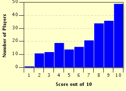
Score Distribution

quiz
Quiz Answer Key and Fun Facts
1. Regular walking can reduce the risk of coronary heart disease, diabetes, stroke, high blood pressure, cancer, osteoporosis and arthritis. It can help you to deal with anxiety and stress, and may reduce the risk of Alzheimer's disease?

Answer: True

According to studies walking just 10,000 steps a day can decrease incidents of major diseases and illnesses. It can also help mental health and release endorphins into the brain to make you feel good.
2. If you are going out for a longer walk, perhaps in the hills or away from the crowds and busy towns as well as suitable footwear what is recommended that you take with you as a minimum?

Answer: a navigation aid, waterproofs and some food/drink

It's a good idea to take as a minimum a map or GPS (it's very easy to get lost, especially if the weather changes, it's also a good idea to know how to use it!), waterproofs (as you get cold very quickly if you get wet - even in the summer) and some food (it keeps your energy up and if you do get lost then you could be out for a lot longer than expected).
All the other stuff you can take with you but should be seen as optional extras.
3. If you walked from Overton Hill in Wiltshire to Ivinghoe Beacon in Buckinghamshire, you would have just completed which National Trail?

Answer: The Ridgeway

The 87 mile long trail follows the line of an ancient trackway across the crest of a chalk ridge. It has been described as Britain's oldest road and passes countless prehistoric burial mounds, the stone circles at Avebury, the Uffington White Horse and several iron age hill forts.
4. Many people go "peakbagging" or set out to climb a particular group of mountains. What is the name given to the group of Scottish mountains that are over 3,000 feet high?

Answer: Munros

Peakbagging involves climbing every hill in a certain set. For example all the mountains above 3,000 feet in Scotland would be a Munro Bagger. If you aimed to climb all of the lake district hills mentioned in Alfred Wainwright's guide books you would be a Wainwright Bagger, etc. Other groups could be all the county high points, the Welsh 3,000 footers, there are loads of possibilities.
5. England and Wales have 14 National Trails. What symbol do they use on their signage to show you are going the right way?

Answer: An acorn

Britain's 14 National Trails have a combined length of around 4,000 miles. In Scotland, they have 4 Long Distance Routes, the symbol for which is a thistle in a hexagon.
6. You are walking along an English bridleway. A cyclist is coming towards you. What is the correct protocol?

Answer: He should give way to you

It is perfectly legal to cycle on a bridleway, however, cyclists should give way to other users. As the name suggests, bridleways can also be used by horse riders.

Footpaths are purely for pedestrians.
7. It's important that you take a detailed map (or equivalent electronic device) with you when you go out and about. The national mapping agency for Great Britain is called what?

Answer: The Ordnance Survey

The ordnance survey got its name from the fact that it was originally set up to provide accurate maps of the country during the Napoleonic Wars when the government was worried about the possibility of a French invasion of Britain. The first map produced was of Kent in 1801.
8. This sugary mint cake is thought of as part of the staple diet of walkers. Which Cumbrian town is it associated with?

Answer: Kendal

Kendal mint cake is made from sugar, water and peppermint oil (sometimes it is covered in chocolate). It is standard kit in the Irish Defense Force's 24 hour ration kit and was taken on expeditions by Edmund Hillary and Ernest Shackleton. The general public seem to think of it as being inextricably linked to walkers and hikers although personally I can't stand it (sorry Kendal Mint cake but you are just too sugary for me).
9. If you were looking at an Ordnance Survey map and saw a symbol that looked like a + sign, what would it mean?

Answer: a church with neither steeple nor tower

Maps are works of art and I could look at them for hours (I do and I know I am very sad). Anyway, by looking at detailed maps before you set out and during the walk you can get a very good idea of the lie of the land; contour lines show the shape and steepness of hills, symbols show buildings, rivers, roads, etc. Among the most useful of the symbols are ones for churches. If you are sat on top of a hill and can see several villages one of the best ways of working out which is which is from the amount and type of churches. Churches with steeples have a different symbol from those with towers and so can be identified easily.
10. A traditional walk that is usually done in aid of charity is?

Answer: Land's End to John O' Groats

Land's End to John O' Groats is a traditional charity walk. The distance covered is around 1,200 miles. John O' Groats is usually cited as being the most northernly tip of Scotland (although Dunnet Head is actually the most northernly point about 2 miles further on), Land's End is thought to be the most southwesterly point of the British mainland.
Source: Author colpeakbagger

This quiz was reviewed by FunTrivia editor WesleyCrusher before going online.
Any errors found in FunTrivia content are routinely corrected through our feedback system.
12/21/2024, Copyright 2024 FunTrivia, Inc. - Report an Error / Contact Us